
Lock Haven is the county seat of Clinton County, in the U.S. state of Pennsylvania. Located near the confluence of the West Branch Susquehanna River and Bald Eagle Creek, it is the principal city of the Lock Haven Micropolitan Statistical Area, itself part of the Williamsport–Lock Haven combined statistical area. At the 2010 census, Lock Haven's population was 9,772.
The Miami and Erie Canal was a 274-mile (441 km) canal that ran from Cincinnati to Toledo, Ohio, creating a water route between the Ohio River and Lake Erie. Construction on the canal began in 1825 and was completed in 1845 at a cost to the state government of $8,062,680.07. At its peak, it included 19 aqueducts, three guard locks, 103 canal locks, multiple feeder canals, and a few man-made water reservoirs. The canal climbed 395 feet (120 m) above Lake Erie and 513 feet (156 m) above the Ohio River to reach a topographical peak called the Loramie Summit, which extended 19 miles (31 km) between New Bremen, Ohio to lock 1-S in Lockington, north of Piqua, Ohio. Boats up to 80 feet long were towed along the canal by mules, horses, or oxen walking on a prepared towpath along the bank, at a rate of four to five miles per hour.

The Patowmack Canal, sometimes called the Potomac Canal, is a series of five inoperative canals located in Maryland and Virginia, United States, that was designed to bypass rapids in the Potomac River upstream of the present Washington, D.C., area. The most well known of them is the Great Falls skirting canal, whose remains are managed by the National Park Service since it is within Great Falls Park, an integral part of the George Washington Memorial Parkway.

The Ohio and Erie Canal was a canal constructed during the 1820s and early 1830s in Ohio. It connected Akron with the Cuyahoga River near its outlet on Lake Erie in Cleveland, and a few years later, with the Ohio River near Portsmouth. It also had connections to other canal systems in Pennsylvania.

The James River and Kanawha Canal was a partially built canal in Virginia intended to facilitate shipments of passengers and freight by water between the western counties of Virginia and the coast. Ultimately its towpath became the roadbed for a rail line following the same course.

The National Register of Historic Places in the United States is a register including buildings, sites, structures, districts, and objects. The Register automatically includes all National Historic Landmarks as well as all historic areas administered by the U.S. National Park Service. Since its introduction in 1966, more than 90,000 separate listings have been added to the register.
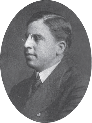
John Eugene Harding was a businessman and one-term member of the United States House of Representatives from Ohio from 1907 to 1909.
The Whitewater Canal, which was built between 1836 and 1847, spanned a distance of 76 miles (122 km) and stretched from Lawrenceburg, Indiana on the Ohio River to Hagerstown, Indiana near the West Fork of the White River.
Miami–Erie Canal Site Historic District is a registered historic district on the Miami and Erie Canal near West Chester, Ohio. The district consists of Lock #38 on the canal, the house used by the lock's gatekeeper, and several foundation sites from demolished canal-related buildings. The limestone lock was built in 1825-26 as part of the original construction of the canal, which connected the Ohio River to Lake Erie. The gatekeeper's house, the second built at the lock, was constructed in 1870; the first house's foundation is still present as well. A mill race connects the lock to the former Friend and Fox Paper Company, which opened a paper mill on the canal in 1866. The paper mill was destroyed by a fire in 1932, though its foundations and retaining walls are still part of the site.

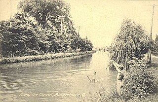
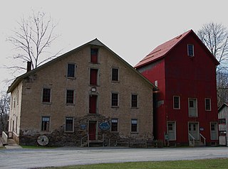
Excello is an unincorporated community in central Lemon Township, Butler County, Ohio, United States, on the south side of Middletown. It comprises roughly the area south of Oxford State Road and State Route 73, west of State Route 4, and east of the Great Miami River. The Excello Lock was a canal lock on the Miami and Erie Canal. Remnants of the lock remain as public property owned by the MCD. Also in Excello was former Harding-Jones Paper Company plant, which is now closed but is on the National Register of Historic Places.

The Cumberland and Oxford Canal was opened in 1832 to connect the largest lakes of southern Maine with the seaport of Portland, Maine. The canal followed the Presumpscot River from Sebago Lake through the towns of Standish, Windham, Gorham, and Westbrook. The Canal diverged from the river at Westbrook to reach the navigable Fore River estuary and Portland Harbor. The canal required 27 locks to reach Sebago Lake at an elevation of 267 feet (81 m) above sea level. One additional lock was constructed in the Songo River to provide 5 feet (1.5 m) of additional elevation to reach Long Lake from Sebago Lake. Total navigable distance was approximately 38 miles (61 km) from Portland to Harrison at the north end of Long Lake. A proposed extension from Harrison to Bear Pond and Tom Pond in Waterford would have required three more locks on the Bear River, but they were never built.
The Jaite Mill Historic District, also known as Jaite, is a nationally recognized historic district in Cuyahoga and Summit counties in the U.S. state of Ohio. The Cuyahoga County portion of the district is located in the city of Brecksville, while the Summit County portion is located in Sagamore Hills Township. Built in 1903 as the Jaite Company Paper Mill, its center is at the intersection of Vaughn and Riverview roads, north of the crossing of Interstates 80 and 271.
Prallsville is an unincorporated community located along New Jersey Route 29 by the border of Stockton and Delaware Township in Hunterdon County, New Jersey. The Delaware River and Wickecheoke Creek border the community. The Prallsville District was listed on the National Register of Historic Places in 1979.
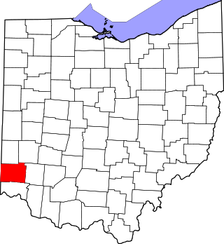
This is a list of the National Register of Historic Places listings in Butler County, Ohio.

The Kent Industrial District is a historic district in Kent, Ohio, United States, listed on the National Register of Historic Places. The district covers around 4.3 acres (1.7 ha) of downtown Kent on either side of the Cuyahoga River and is roughly bounded by West Main Street on the north, River Street to the west, Franklin Avenue to the east and Haymaker Parkway to the south. Within the district are three buildings and two stone structures of historical significance. It was listed on the National Register of Historic Places in 1974. Kent namesake Marvin Kent was involved in several aspects of the district's development and the area would play a key role in the development of Kent during much of the 19th century. The earliest structures in the district date to the 1830s with the most recent historic structure, the livery and carriage shop building, dating to 1910. The area today is occupied mostly by the city of Kent's Franklin Mills Riveredge Park, Heritage Park, and various private landowners.

The Cascade Locks Historic District is a historic district located in Akron, Ohio. It was added to the National Register of Historic Places in 1992.

Gaston's Mill-Lock No. 36, Sandy and Beaver Canal District, is a historic district listed in the National Register of Historic Places. The district is located within Beaver Creek State Park, approximately 1 mile south of Clarkson, Ohio. Gaston's Mill was constructed in 1837 and was powered by Little Beaver Creek. Lock 36 was one of 90 locks on the Sandy and Beaver Canal. Construction of this canal began in 1834 but was not completed until 1848.

Peninsula Village Historic District is a historic district located on both sides of Ohio State Route 303 in Peninsula, Ohio. The district encompasses the historic core of Peninsula, which is situated inside of Cuyahoga Valley National Park. Peninsula was settled by Hermon Bronson in 1824 and platted in 1837; in its early years, it was a stop along the Ohio and Erie Canal and home to a mill on the Cuyahoga River. Canal traffic and the construction of the Valley Railway in 1875 spurred the village's continued economic growth through the nineteenth century. The district includes examples of Greek Revival, Federal style, and Italianate architecture, all of which were popular nineteenth century styles. Significant buildings in the district include the Town Hall, a railroad depot, Peninsula High School, the G.A.R. Hall, and three churches.

Seneca Aqueduct — or Aqueduct No. 1 — is a naviduct that carries the Chesapeake and Ohio Canal (C&O) over Seneca Creek in Montgomery County, Maryland. The C&O built eleven aqueducts along its 184.5 miles (296.9 km) length. Seneca Aqueduct is a unique structure, not only being the first built, but also the only red sandstone aqueduct on the C&O−and the only aqueduct that is also a lock. It is located at the end of Riley's Lock Road in Seneca, Maryland.

Riley's Lock (Lock 24) and lock house are part of the 184.5-mile (296.9 km) Chesapeake and Ohio Canal that operated in the United States along the Potomac River from the 1830s through 1923. They are located at towpath mile-marker 22.7 adjacent to Seneca Creek, in Montgomery County, Maryland. The lock is sometimes identified as Seneca because of the Seneca Aqueduct that carried the canal over the creek to the lift lock. The name Riley comes from John C. Riley, who was lock keeper from 1892 until the canal closed permanently in 1924.


