
A henge loosely describes one of three related types of Neolithic earthwork. The essential characteristic of all three is that they feature a ring-shaped bank and ditch, with the ditch inside the bank. Because the internal ditches would have served defensive purposes poorly, henges are not considered to have been defensive constructions. The three henge types are as follows, with the figure in brackets being the approximate diameter of the central flat area:
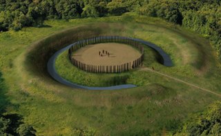
- Henge. The word henge refers to a particular type of earthwork of the Neolithic period, typically consisting of a roughly circular or oval-shaped bank with an internal ditch surrounding a central flat area of more than 20 m (66 ft) in diameter. There is typically little if any evidence of occupation in a henge, although they may contain ritual structures such as stone circles, timber circles and coves. Henge monument is sometimes used as a synonym for henge. Henges sometimes, but by no means always, featured stone or timber circles, and circle henge is sometimes used to describe these structures. The three largest stone circles in Britain are each within a henge. Examples of henges without significant internal monuments are the three henges of Thornborough Henges. Although having given its name to the word henge, Stonehenge is atypical in that the ditch is outside the main earthwork bank.
- Hengiform monument. Like an ordinary henge, except the central flat area is between 5 and 20 m (16–66 ft) in diameter, they comprise a modest earthwork with a fairly wide outer bank. The terms mini-henge or Dorchester henge are sometimes used as synonyms for hengiform monument. An example is the Neolithic site at Wormy Hillock Henge.
- Henge enclosure. A Neolithic ring earthwork with the ditch inside the bank, with the central flat area having abundant evidence of occupation and usually being more than 300 m (980 ft) in diameter. Some true henges are as large as this, but lack evidence of domestic occupation. Super-henge or superhenge is sometimes used as a synonym for a henge enclosure. However, sometimes the term is used to indicate size alone rather than use, e.g. "Marden henge ... is the least understood of the four British 'superhenges' ".

A causewayed enclosure is a type of large prehistoric earthwork common to the early Neolithic in Europe. It is an enclosure marked out by ditches and banks, with a number of causeways crossing the ditches. More than 100 examples are recorded in France and 70 in Southern England and Wales, while further sites are known in Scandinavia, Belgium, Germany, Italy, Ireland and Slovakia.

Windmill Hill is a Neolithic causewayed enclosure in the English county of Wiltshire, part of the Avebury World Heritage Site, about 1 mile (2 km) northwest of Avebury. Enclosing an area of 21 acres (8.5 ha), it is the largest known causewayed enclosure in Britain. The site was first occupied around 3800 BC, although the only evidence is a series of pits apparently dug by an agrarian society using Hembury pottery.
Combe Hill is a causewayed enclosure, near Eastbourne in East Sussex, on the northern edge of the South Downs. It consists of an inner circuit of ditches and banks, incomplete where it meets a steep slope on its north side, and the remains of an outer circuit. Causewayed enclosures were built in England from shortly before 3700 BC until at least 3500 BC; they are characterized by the full or partial enclosure of an area with ditches that are interrupted by gaps, or causeways. Their purpose is not known; they may have been settlements, meeting places, or ritual sites. The historian Hadrian Allcroft included the site in his 1908 book Earthwork of England, and in 1930 E. Cecil Curwen listed it as a possible Neolithic site in a paper which attempted to provide the first list of all the causewayed enclosures in England.
Hambledon Hill is a prehistoric hill fort in Dorset, England, in the Blackmore Vale five miles northwest of Blandford Forum. The hill itself is a chalk outcrop, on the southwestern corner of Cranborne Chase, separated from the Dorset Downs by the River Stour. It is owned by the National Trust.

Flagstones is a late Neolithic interrupted ditch enclosure on the outskirts of Dorchester, Dorset, England. It derives its name from having been discovered beneath the site of the demolished Flagstones House. Half of it was excavated in the 1980s when the Dorchester by-pass was built; the rest of it still exists under the grounds of Max Gate, Thomas Hardy's house.
In archaeology, a ring ditch is a trench of circular or penannular plan, cut into bedrock. They are usually identified through aerial photography either as soil marks or cropmarks. When excavated, ring ditches are usually found to be the ploughed‐out remains of a round barrow where the barrow mound has completely disappeared, leaving only the infilled former quarry ditch. Both Neolithic and Bronze Age ring ditches have been discovered.
Robin Hood’s Ball is a Neolithic causewayed enclosure on Salisbury Plain in Wiltshire, England, approximately 5 miles (8 km) northwest of the town of Amesbury, and 2+1⁄2 miles (4.0 km) northwest of Stonehenge. The site was designated as a scheduled monument in 1965.

Figsbury Ring is an 11.2 hectare biological Site of Special Scientific Interest in Wiltshire, England, notified in 1975. It is owned and managed by the National Trust.
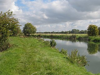
Chimney is a hamlet and former civil parish, now in the parish of Aston, Cote, Shifford and Chimney, in the West Oxfordshire district, in the county of Oxfordshire, England. It is on the River Thames near Shifford Lock, 6 miles (9.7 km) south of Witney. Chimney Meadows 620 acres (250 ha) is the largest nature reserve managed by the Berkshire, Buckinghamshire and Oxfordshire Wildlife Trust.

Priddy Circles are a linear arrangement of four circular earthwork enclosures near the village of Priddy on the Mendip Hills in Somerset, England. The circles have been listed as Scheduled Ancient Monuments, and described as 'probable Neolithic ritual or ceremonial monuments similar to a henge'.

The Trundle is an Iron Age hillfort on St Roche's Hill about 4 miles (6 km) north of Chichester, West Sussex, England. It was built on the site of a causewayed enclosure, a form of early Neolithic earthwork found in northwestern Europe. Causewayed enclosures were built in England from shortly before 3700 BC until at least 3500 BC; they are characterized by the full or partial enclosure of an area with ditches that are interrupted by gaps, or causeways. Their purpose is not known; they may have been settlements, meeting places, or ritual sites. Hillforts were built as early as 1000 BC, in the Late Bronze Age, and continued to be built through the Iron Age until shortly before the Roman occupation.
The Mount Horeb Earthworks Complex is an Adena culture group of earthworks in Lexington, Kentucky. It consists of two major components, the Mount Horeb Site 1 and the Peter Village enclosure, and several smaller features including the Grimes Village site, Tarleton Mound, and Fisher Mound. The Peter Village and Grimes Village enclosures were mapped by Rafinesque and featured in Squier and Davis's landmark publication Ancient Monuments of the Mississippi Valley in 1848 as Plate XIV Figures 3 and 4.

Whitehawk Camp is the remains of a causewayed enclosure on Whitehawk Hill near Brighton, East Sussex, England. Causewayed enclosures are a form of early Neolithic earthwork that were built in England from shortly before 3700 BC until at least 3500 BC, characterized by the full or partial enclosure of an area with ditches that are interrupted by gaps, or causeways. Their purpose is not known; they may have been settlements, or meeting places, or ritual sites. The Whitehawk site consists of four roughly concentric circular ditches, with banks of earth along the interior of the ditches evident in some places. There may have been a timber palisade on top of the banks. Outside the outermost circuit there are at least two more ditches, one of which is thought from radiocarbon evidence to date to the Bronze Age, about two thousand years after the earliest dated activity at the site.

Knap Hill lies on the northern rim of the Vale of Pewsey, in northern Wiltshire, England, about a mile north of the village of Alton Priors. At the top of the hill is a causewayed enclosure, a form of Neolithic earthwork that was constructed in England from about 3700 BC onwards, characterized by the full or partial enclosure of an area with ditches that are interrupted by gaps, or causeways. Their purpose is not known: they may have been settlements, or meeting places, or ritual sites of some kind. The site has been scheduled as an ancient monument.

Beacon Hill, also known as Harting Beacon, is a hillfort on the South Downs, in the county of West Sussex in southern England. The hillfort is located in the parish of Elsted and Treyford, in Chichester District. It is a Scheduled Ancient Monument with a list entry identification number of 1015915. The hilltop enclosure is dated to the Late Bronze Age, from the 8th to 6th centuries BC. The hillfort defences were renewed during the Late Iron Age.

Castle Goff is an enclosure about 1.5 miles (2.4 km) south-west of Camelford, in Cornwall, England. It is a scheduled monument.

Buzbury Rings is an Iron Age hillfort about 2 miles (3.2 km) east of Blandford Forum and 1 mile (1.6 km) northwest of the village of Tarrant Keyneston, in Dorset, England.
Barkhale Camp is a Neolithic causewayed enclosure, an archaeological site on Bignor Hill, on the South Downs in West Sussex, England. Causewayed enclosures were built in England from shortly before 3700 BC until at least 3500 BC; they are characterized by the full or partial enclosure of an area with ditches that are interrupted by gaps, or causeways. Their purpose is not known; they may have been settlements, meeting places, or ritual sites. The Barkhale Camp enclosure was first identified in 1929, by John Ryle, and was surveyed the following year by E. Cecil Curwen, who listed it as a possible Neolithic site in a 1930 paper which was the first attempt to list all the causewayed enclosures in England.

Offham Hill is a causewayed enclosure near Lewes, East Sussex, England. Causewayed enclosures were built in England from shortly before 3700 BC until about 3300 BC; they are characterized by the full or partial enclosure of an area with ditches that are interrupted by gaps, or causeways. Their purpose is not known; they may have been settlements, meeting places, or ritual sites. The site was identified as a possible causewayed enclosure in 1964 by a member of the Sussex Archaeological Society. The Ordnance Survey inspected the site in 1972 and recommended an excavation, which was carried out in 1976 by Peter Drewett.