Chardon, Ohio

Last updated

Chardon, Ohio
BrewWorks & Eatery P7010567.jpg
Motto: 
"Home of the Geauga County Maple Festival"
OHMap-doton-Chardon.png
Location of Chardon, Ohio
Map of Geauga County Ohio Highlighting Chardon City.png
Location of Chardon in Geauga County
Coordinates: 41°34′47″N81°12′25″W / 41.57972°N 81.20694°W / 41.57972; -81.20694 [1]
Country United States
State Ohio
County Geauga
Government
  Type Council-manager
  MayorChristopher Grau [2]
  Vice MayorHeather Means [3]
Area
[4]
  Total4.42 sq mi (11.46 km2)
  Land4.39 sq mi (11.37 km2)
  Water0.03 sq mi (0.09 km2)
Elevation
[1]
1,240 ft (380 m)
Population
 (2020)
  Total5,242
  Density1,193.81/sq mi (460.93/km2)
Time zone UTC-5 (Eastern (EST))
  Summer (DST) UTC-4 (EDT)
ZIP code
44024
Area code(s) 440 and 436
FIPS code 39-13554 [5]
GNIS feature ID2397604 [1]
Website Chardon.cc

Chardon is a city in and the county seat of Geauga County, Ohio, United States. [6] [7] The population was 5,242 at the 2020 census. [8] It is the only incorporated city in Geauga County, and includes land that was once part of Chardon, Hambden and Munson townships. [9] It is located about 10 miles south of Lake Erie and within the "snow belt" of the Great Lakes and is part of the Cleveland metropolitan area.

Contents

History

Main Street after the fire of 1868 Geauga County Fire of 1868.jpg
Main Street after the fire of 1868

Chardon is named after Peter Chardon Brooks, who donated land to build the historic Chardon Square. [8] Chardon Township celebrates its incorporation in 1812, and thus the City of Chardon does the same. [10]

On July 24–25, 1868, a massive fire totally destroyed the center of uptown, the area now known as Chardon Square. The fire originated in the Parlin Parkin's grocery store, and spread rapidly. By the time the fire was contained, the courthouse, post office, and many stores on the square were destroyed. Damage was estimated at around $120,000. [11] Chardon Square was quickly rebuilt following the fire. A new county courthouse, which still stands today, was completed in 1869. Many other buildings that were constructed after the fire also survive and are used today. [8]

School shooting

On February 27, 2012, a student from Lake Academy in Willoughby, Ohio opened fire at the Chardon High School cafeteria, killing three and injuring two students. Daniel Parmertor, 16 years old, was killed at the time of the shooting. Two other victims, Demetrius Hewlin and Russell King, Jr., were pronounced dead on February 28. [12] The shooter was taken into custody by police and was charged with three counts of aggravated murder. He was sentenced to three consecutive life terms in prison without parole. [13] [14]

Geography

Chardon is located on U.S. Route 6 about 15 miles (24 km) east of Cleveland. According to the United States Census Bureau, the city has a total area of 4.62 square miles (11.97 km2), of which 4.58 square miles (11.86 km2) is land and 0.04 square miles (0.10 km2) or about 25 acres (10 ha) is water. [15]

Climate

With an average annual snowfall of 107 inches (272 cm), [16] [17] Chardon is notable for being the snowiest city in Ohio. [18] This is mainly due to its location on a 730-foot (223 m) ridge approximately 10 miles (16 km) inland from Lake Erie, creating the perfect conditions for orographic lift and its associated heavy snowfall when winter winds blow across the lake.[ citation needed ]

In 1996, from November 9 through November 13, a storm dropped over 70 inches (178 cm) of lake-effect snow in the city over a period of six days. [19] [20] Governor George Voinovich declared a state of emergency as a result, and the Ohio National Guard was brought in to assist with the cleanup. [21]

Chardon has a humid continental climate (Dfb). Summer days are warm to hot while nights remain cool. Summer is also the rainiest time of the year. Winters are moderately long, cold, and very snowy. Precipitation peaks during the month of August.

Climate data for Chardon, Ohio, 1991–2020 normals, extremes 1945present
MonthJanFebMarAprMayJunJulAugSepOctNovDecYear
Record high °F (°C)70
(21)
73
(23)
82
(28)
88
(31)
92
(33)
100
(38)
98
(37)
97
(36)
98
(37)
87
(31)
80
(27)
73
(23)
100
(38)
Mean maximum °F (°C)56.6
(13.7)
58.2
(14.6)
69.0
(20.6)
79.7
(26.5)
85.5
(29.7)
90.0
(32.2)
90.9
(32.7)
89.7
(32.1)
87.1
(30.6)
78.3
(25.7)
67.9
(19.9)
58.4
(14.7)
92.2
(33.4)
Mean daily maximum °F (°C)32.5
(0.3)
35.0
(1.7)
43.8
(6.6)
57.6
(14.2)
68.7
(20.4)
77.2
(25.1)
81.0
(27.2)
79.5
(26.4)
73.0
(22.8)
60.8
(16.0)
48.3
(9.1)
37.6
(3.1)
57.9
(14.4)
Daily mean °F (°C)24.6
(−4.1)
25.8
(−3.4)
34.0
(1.1)
46.2
(7.9)
57.2
(14.0)
66.2
(19.0)
70.0
(21.1)
68.4
(20.2)
61.9
(16.6)
50.7
(10.4)
40.1
(4.5)
30.8
(−0.7)
48.0
(8.9)
Mean daily minimum °F (°C)16.8
(−8.4)
16.5
(−8.6)
24.2
(−4.3)
34.8
(1.6)
45.7
(7.6)
55.1
(12.8)
59.1
(15.1)
57.3
(14.1)
50.8
(10.4)
40.6
(4.8)
31.9
(−0.1)
24.0
(−4.4)
38.1
(3.4)
Mean minimum °F (°C)−5.9
(−21.1)
−4.8
(−20.4)
3.1
(−16.1)
21.6
(−5.8)
31.2
(−0.4)
40.3
(4.6)
47.7
(8.7)
46.3
(7.9)
38.0
(3.3)
28.3
(−2.1)
17.4
(−8.1)
5.6
(−14.7)
−9.7
(−23.2)
Record low °F (°C)−23
(−31)
−29
(−34)
−18
(−28)
5
(−15)
22
(−6)
30
(−1)
38
(3)
33
(1)
25
(−4)
15
(−9)
−2
(−19)
−21
(−29)
−29
(−34)
Average precipitation inches (mm)4.19
(106)
3.14
(80)
3.69
(94)
4.29
(109)
4.41
(112)
4.55
(116)
4.72
(120)
4.13
(105)
4.52
(115)
4.47
(114)
4.29
(109)
4.31
(109)
50.71
(1,289)
Average snowfall inches (cm)34.4
(87)
23.4
(59)
16.5
(42)
4.0
(10)
0.0
(0.0)
0.0
(0.0)
0.0
(0.0)
0.0
(0.0)
0.0
(0.0)
0.6
(1.5)
9.3
(24)
25.5
(65)
113.7
(288.5)
Average extreme snow depth inches (cm)13.4
(34)
12.2
(31)
8.7
(22)
2.1
(5.3)
0.0
(0.0)
0.0
(0.0)
0.0
(0.0)
0.0
(0.0)
0.0
(0.0)
0.6
(1.5)
5.6
(14)
9.8
(25)
18.6
(47)
Average precipitation days (≥ 0.01 in)20.015.613.814.314.112.711.410.711.213.814.917.6170.1
Average snowy days (≥ 0.1 in)15.010.96.01.70.00.00.00.00.00.33.89.847.5
Source: NOAA [22] [23]

Demographics

Historical population
CensusPop.Note
1830 381
1840 44617.1%
1850 54622.4%
1860 5826.6%
1870 88552.1%
1880 1,08122.1%
1890 1,0840.3%
1900 1,36025.5%
1910 1,54213.4%
1920 1,5661.6%
1930 1,81816.1%
1940 2,00110.1%
1950 2,47823.8%
1960 3,15427.3%
1970 3,99126.5%
1980 4,43411.1%
1990 4,4460.3%
2000 5,15616.0%
2010 5,148−0.2%
2020 5,2421.8%
Sources: [24] [25] [26] [27] [28] [29] [5]

[30] As of the census [5] of 2000, there were 5,156 people, 2,147 households, and 1,344 families residing in the city. The population density was 1,120.1 inhabitants per square mile (432.5/km2). There were 2,271 housing units at an average density of 493.3 per square mile (190.5/km2). The racial makeup of the city was 97.77% White, 0.43% African American, 0.02% Native American, 0.45% Asian, 0.02% Pacific Islander, 0.10% from other races, and 1.22% from two or more races. Hispanic or Latino of any race were 0.47% of the population.

There were 2,147 households, out of which 30.5% had children under the age of 18 living with them, 49.7% were married couples living together, 9.9% had a female householder with no husband present, and 37.4% were non-families. 32.9% of all households were made up of individuals, and 13.7% had someone living alone who was 65 years of age or older. The average household size was 2.35 and the average family size was 3.02.

In the city the population was spread out, with 24.9% under the age of 18, 6.9% from 18 to 24, 29.9% from 25 to 44, 22.5% from 45 to 64, and 15.8% who were 65 years of age or older. The median age was 37 years. For every 100 females, there were 84.9 males. For every 100 females age 18 and over, there were 79.3 males.

The median income for a household in the city was $54,063, and the median income for a family was $57,845. Males had a median income of $44,071 versus $23,750 for females. The per capita income for the city was $21,845. About 1.3% of families and 3.8% of the population were below the poverty line, including 0.6% of those under age 18 and 7.8% of those age 65 or over.

2010 census

As of the census [31] of 2010, there were 5,148 people, 2,285 households, and 1,331 families residing in the city. The population density was 1,124.0 inhabitants per square mile (434.0/km2). There were 2,457 housing units at an average density of 536.5 per square mile (207.1/km2). The racial makeup of the city was 96.9% White, 0.8% Black, 0.2% Native American, 0.6% Asian, 0.2% from other races, and 1.3% from two or more races. Hispanic or Latino of any race were 1.5% of the population.

There were 2,285 households, of which 29.1% had children under the age of 18 living with them, 42.1% were married couples living together, 12.2% had a female householder with no husband present, 3.9% had a male householder with no wife present, and 41.8% were non-families. 37.4% of all households were made up of individuals, and 15.8% had someone living alone who was 65 years of age or older. The average household size was 2.21 and the average family size was 2.94.

The median age in the city was 41.1 years. 23.5% of residents were under the age of 18; 7.4% were between the ages of 18 and 24; 24.8% were from 25 to 44; 26.5% were from 45 to 64; and 17.7% were 65 years of age or older. The gender makeup of the city was 45.1% male and 54.9% female.

Culture

Bathtub races at the 2018 Geauga County Maple Festival BathTub races.jpg
Bathtub races at the 2018 Geauga County Maple Festival

Chardon is known for its maple syrup industry. Celebration of the syrup season begins at Tapping Sunday in March, when the sap is at prime thawing temperature. The annual Geauga County Maple Festival [32] is a four-day celebration that takes place on the Chardon Square the last weekend in April. The festival has been rescheduled numerous times because of snowstorms in April due to Chardon's location in the “snow belt” of the Great Lakes; it receives a large amount of snowfall every year.

Chardon has an active performance art community. The Geauga Lyric Theater Guild is housed in the renovated Geauga Theater building, which was constructed in 1939 as an Art Deco movie house. The theater is also being used again to show first-run movies. [33] [34]

Greater Chardon features numerous parks and golf courses. Chardon Lakes Golf Course is located in the heart of Chardon, two minutes from the square. Sand Ridge Golf Club in nearby Munson Township is also an excellent course. Chardon has an abundance of park space. Due to the area's varying weather conditions, sports activities are available for every season.

Education

Chardon and the area surrounding the city are served by the Chardon Local School District. The district contains Chardon High School, as well as one middle school, and two elementary schools: Park and Munson. Hambden and Maple were no longer elementary schools starting in the 2018–2019 school year. Hambden and Munson elementary are not within the city limits. [35] As of the 2011–2012 school year, the district had received an "Excellent" rating from the State of Ohio Board of Education for eleven consecutive years. [36]

Chardon has a public library, a branch of the Geauga County Public Library. [37]

Notable people

Musical artists & groups

Related Research Articles

<span class="mw-page-title-main">Lake County, Ohio</span> County in Ohio, United States

Lake County is a county in the U.S. state of Ohio. As of the 2020 census, the population was 232,603. Its county seat is Painesville, and its largest city is Mentor.

<span class="mw-page-title-main">Geauga County, Ohio</span> County in Ohio, United States

Geauga County is a county in the U.S. state of Ohio. As of the 2020 census, the population was 95,397. The county seat and largest city is Chardon.

<span class="mw-page-title-main">Erie County, Ohio</span> County in Ohio, United States

Erie County is a county located in the northern portion of the U.S. state of Ohio. As of the 2020 census, the population was 75,622. Its county seat and largest city is Sandusky. The county is named for the Erie tribe, whose name was their word for "wildcat". It was formed in 1838 from the northern third of Huron County and a portion of Sandusky County.

<span class="mw-page-title-main">Ashtabula County, Ohio</span> County in Ohio, United States

Ashtabula County is the northeasternmost county in the U.S. state of Ohio. As of the 2020 census, the population was 97,574. The county seat is Jefferson, while its largest city is Ashtabula. The county was created in 1808 and later organized in 1811. The name Ashtabula derives from the Lenape language phrase ashte-pihële, which translates to 'always enough (fish) to go around, to be given away' and is a contraction of apchi ('always') + tepi ('enough') + hële. Ashtabula County is part of the Cleveland, OH Metropolitan Statistical Area.

<span class="mw-page-title-main">Geneva-on-the-Lake, Ohio</span> Village in Ohio, United States

Geneva-on-the-Lake is a village in northwestern Ashtabula County, Ohio, United States, along the southern shore of Lake Erie. A small resort town, the population was 916 at the 2020 census. It is part of the Ashtabula micropolitan area, 46 miles (74 km) northeast of Cleveland.

<span class="mw-page-title-main">Euclid, Ohio</span> City in Ohio, United States

Euclid is a city in Cuyahoga County, Ohio, United States. Located on the southern shore of Lake Erie, it is an inner ring suburb of Cleveland. The population was 49,692 at the 2020 census, making it the fourth largest city in Cuyahoga County.

<span class="mw-page-title-main">Burton, Ohio</span> Village in Ohio, United States

Burton is a village in Geauga County, Ohio, United States. The population was 1,407 at the 2020 census. It is part of the Cleveland metropolitan area. Burton is the location of Century Village, run by the Geauga Historical Society. The museum village is composed of 19th-century buildings moved there from other locations. Many special events are held there each year, as well as at the Geauga County Fairgrounds, also in Burton.

<span class="mw-page-title-main">Chesterland, Ohio</span> Census-designated place in Ohio, United States

Chesterland is a census-designated place (CDP) in Geauga County, Ohio, United States. As of the 2020 census, the CDP had a population of 7,074.

<span class="mw-page-title-main">Middlefield, Ohio</span> Village in Ohio, United States

Middlefield is a village in Geauga County, Ohio, United States. The population was 2,748 at the 2020 census. It is part of the Cleveland metropolitan area. Middlefield is known for being the center of the world's fourth largest Amish settlement, and its significant manufacturing base, which includes Gold Key Processing, Inc., Duncan Toys and KraftMaid. Because of its central location, home of the areas' public schools and prominent business and retail presence, Middlefield village is considered the hub community for Huntsburg, Parkman, and Middlefield Townships.

<span class="mw-page-title-main">South Russell, Ohio</span> Village in Ohio, United States

South Russell is a village in Geauga County, Ohio, United States. The population was 3,972 at the 2020 census. It is part of the Cleveland metropolitan area.

<span class="mw-page-title-main">Eastlake, Ohio</span> City in Ohio, United States

Eastlake is a city in Lake County, Ohio, United States. It takes its name from its location northeast of Cleveland, following along the shore of Lake Erie. The population was 17,670 at the 2020 census. The 2003 North America blackout stemmed from an Eastlake generating station going offline.

<span class="mw-page-title-main">Kirtland, Ohio</span> City in Ohio, United States

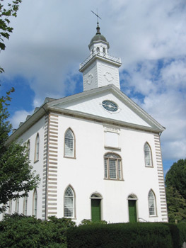
Kirtland is a city in Lake County, Ohio, United States. The population was 6,937 at the 2020 census. Kirtland is known for being the early headquarters of the Latter Day Saint movement from 1831 to 1837 and the site of the movement's first temple, the Kirtland Temple, completed in 1836. The Kirtland Temple and nearby Historic Kirtland Village are maintained as historic sites highlighting that era. The city is also the location for multiple parks in the Lake Metroparks system, as well as the Holden Arboretum.

<span class="mw-page-title-main">Painesville, Ohio</span> City in Ohio, United States

Painesville is a city in and the county seat of Lake County, Ohio, United States, located along the Grand River 27 miles (43 km) It is a northeast suburb of Cleveland. Its population was 20,312 at the 2020 census. Painesville is part of the Greater Cleveland Metropolitan Area and is included in the Cleveland-Akron-Canton, Ohio Consolidated Metropolitan Statistical Area.

<span class="mw-page-title-main">North Ridgeville, Ohio</span> City in Ohio, United States

North Ridgeville is a city located along the eastern border of Lorain County, Ohio, United States. The city's population was 35,280 as of the 2020 census. A part of the Cleveland metropolitan area, North Ridgeville is the fastest-growing city in northern Ohio. It has been ranked the 13th safest city in the United States and the safest in Ohio.

<span class="mw-page-title-main">Aurora, Ohio</span> City in Ohio, United States

Aurora is a city in northwestern Portage County, Ohio, United States. A suburb in between Akron and Cleveland, the population was 17,239 at the 2020 census. It is part of the Akron metropolitan area.

Bainbridge is a census-designated place (CDP) in Bainbridge Township, Geauga County, Ohio, United States. As of the 2020 census, the CDP had a population of 9,242.

<span class="mw-page-title-main">Munson Township, Geauga County, Ohio</span> Township in Ohio, United States

Munson Township is one of the sixteen townships of Geauga County, Ohio, United States. As of the 2020 census the population was 7,087.

<span class="mw-page-title-main">Claridon Township, Geauga County, Ohio</span> Township in Ohio, United States

Claridon Township is one of the sixteen townships of Geauga County, Ohio, United States. As of the 2020 census the population was 3,103, of whom 2,865 lived in the unincorporated portions of the township.

<span class="mw-page-title-main">Chardon Township, Ohio</span> Township in Ohio, United States

Chardon Township is one of the sixteen townships of Geauga County, Ohio, United States. As of the 2020 census the population was 4,494.

<span class="mw-page-title-main">Hambden Township, Geauga County, Ohio</span> Township in Ohio, United States

Hambden Township is one of the sixteen townships of Geauga County, Ohio, United States. As of the 2020 census the population was 4,676, up from 4,024 at the 2000 census.

References

  1. 1 2 3 U.S. Geological Survey Geographic Names Information System: Chardon, Ohio
  2. "City Council". Chardon, OH - Official Website. Retrieved March 12, 2024.
  3. "City Council". Chardon, OH - Official Website. Retrieved March 12, 2024.
  4. "ArcGIS REST Services Directory". United States Census Bureau. Retrieved September 20, 2022.
  5. 1 2 3 "U.S. Census website". United States Census Bureau . Retrieved January 31, 2008.
  6. "Find a County". National Association of Counties. Archived from the original on May 31, 2011. Retrieved June 7, 2011.
  7. "Chardon: United States, name, administrative division, geographic coordinates and map". Geographical Names. Retrieved February 4, 2015.
  8. 1 2 3 City of Chardon - History Archived August 30, 2011, at the Wayback Machine .
  9. File:Map of Geauga County Ohio With Municipal and Township Labels.PNG.
  10. "Chardon's Bicentennial Celebration! Home". Archived from the original on August 11, 2012. Retrieved May 5, 2012..
  11. Terrible Conflagration.; The Entire Business Portion of Chardon, Ohio, in Ashes-Loss Over $100,000. The New York Times , August 1, 1868.
  12. "Chardon High School Shootings: 3rd Student is Dead". Fox8 Cleveland. February 28, 2012.
  13. "FBI, hospitals, say 5 students injured when classmate opens fire at Ohio high school". The Washington Post . February 27, 2012. Archived from the original on February 28, 2012. Retrieved February 27, 2012.
  14. "T.J. Lane wears 'Killer' shirt at sentencing; judge sends him to life in prison without parole (gallery, videos)". The Plain Dealer . March 19, 2013. Retrieved March 19, 2013.
  15. "US Gazetteer files 2010". United States Census Bureau. Archived from the original on January 25, 2012. Retrieved January 6, 2013.
  16. Schmidlin, Thomas W. (September 1989). "Climatic Summary of Snowfall and Snow Depth in the Ohio Snowbelt at Chardon". The Ohio Journal of Science. 89 (4): 101–108. hdl:1811/23329.
  17. City of Chardon - Snowfall Archived March 16, 2011, at the Wayback Machine
  18. Chardon ranks as one of the snowiest cities
  19. Data and Analyses, November 9-14, 1996 in the Great Lakes - WW2010 Archives, University of Illinois.
  20. National Agricultural Summary, November 11-17, 1996 - National Agricultural Statistics Service, United States Department of Agriculture.
  21. Albrecht, Brian E (November 17, 1996). "So much, so soon; Snowfall will have place among stories of survival in Cleveland weatherlore". The Plain Dealer . Retrieved March 5, 2008.
  22. "NOAA NCEI U.S. Climate Normals Quick Access". NOAA. Retrieved January 11, 2023.
  23. "NOAA Online Weather Data – NWS Cleveland". National Weather Service. Retrieved January 27, 2023.
  24. "Population of Civil Divisions Less than Counties" (PDF). Statistics of the Population of the United States at the Ninth Census. U.S. Census Bureau. 1870. Retrieved April 24, 2020.
  25. "Population of Civil Divisions Less than Counties" (PDF). Statistics of the Population of the United States at the Tenth Census. U.S. Census Bureau. 1880. Retrieved November 28, 2013.
  26. "Population: Ohio" (PDF). 1910 U.S. Census. U.S. Census Bureau. Retrieved November 28, 2013.
  27. "Population: Ohio" (PDF). 1930 US Census. U.S. Census Bureau. Retrieved November 28, 2013.
  28. "Number of Inhabitants: Ohio" (PDF). 18th Census of the United States. U.S. Census Bureau. 1960. Retrieved April 24, 2020.
  29. "Ohio: Population and Housing Unit Counts" (PDF). U.S. Census Bureau. Retrieved November 22, 2013.
  30. https://www.census.gov/quickfacts/fact/table/chardoncityohio/PST045219 [ dead link ]
  31. "U.S. Census website". United States Census Bureau . Retrieved January 6, 2013.
  32. Geauga County Maple Festival official site
  33. "Guild restores murals that set the tone for Chardon's 1939, art deco cinema", The Plain Dealer , February 5, 2001.
  34. Movies for 4 Archived February 2, 2009, at the Wayback Machine - Geauga Lyric Theater Guild website.
  35. "Our Schools".
  36. About the District. Retrieved from http://www.chardon.k12.oh.us/AbouttheDistrict.aspx.
  37. "Locations". Geauga County Public Library. Archived from the original on February 25, 2018. Retrieved February 25, 2018.