"},"elevation_ft":{"wt":"1063"},"postal_code_type":{"wt":"Zip code"},"postal_code":{"wt":"45133"},"area_code":{"wt":"[[Area codes 937 and 326|937, 326]]"},"website":{"wt":"{{URL|http://hillsboroohio.net}}"},"blank_name":{"wt":"[[Federal Information Processing Standard|FIPS code]]"},"blank_info":{"wt":"39-35560{{cite web|url=https://www.census.gov|publisher=[[United States Census Bureau]]|access-date=2008-01-31|title=U.S. Census website}}"},"blank1_name":{"wt":"[[Geographic Names Information System|GNIS]] feature ID"},"blank1_info":{"wt":"2394385{{GNIS|2394385}}"},"footnotes":{"wt":""},"unit_pref":{"wt":"Imperial"}},"i":0}}]}" id="mwBQ">City in Ohio, United States
Hillsboro, Ohio | |
---|---|
High Street; the tall structure is the Bell Opera House | |
Motto: "Where Pride Rings True..." | |
![]() Location in Highland County, Ohio | |
Coordinates: 39°12′28″N83°37′10″W / 39.20778°N 83.61944°W | |
Country | United States |
State | Ohio |
County | Highland |
Government | |
• Mayor | Justin Harsha[ citation needed ] |
Area | |
• Total | 5.47 sq mi (14.18 km2) |
• Land | 5.47 sq mi (14.18 km2) |
• Water | 0.00 sq mi (0.00 km2) 0% |
Elevation | 1,063 ft (324 m) |
Population (2020) | |
• Total | 6,481 |
6,617 | |
• Density | 1,183.74/sq mi (457.07/km2) |
Time zone | UTC-4 (EST) |
• Summer (DST) | UTC-4 (EDT) |
Zip code | 45133 |
Area code(s) | 937, 326 |
FIPS code | 39-35560 [4] |
GNIS feature ID | 2394385 [2] |
Website | hillsboroohio |
Hillsboro is a city in and the county seat of Highland County, Ohio, United States, [5] approximately 35 miles (56 km) west of Chillicothe and 50 miles (80 km) east of Cincinnati. The population was 6,481 at the 2020 census.
Hillsboro was platted in 1807, and most likely named for the hills near the original town site. [6] One of the late 19th century's largest reform organizations, the Woman's Christian Temperance Union that went on to play important roles in achieving women's suffrage and prohibition, was founded in Hillsboro in 1873.
According to the United States Census Bureau, the city has a total area of 5.43 square miles (14.06 km2), all land. [7]
Hillsboro is located at the junction of U.S. Routes 50 and 62 and State Routes 73, 124, 138, and 247.
Climate data for Hillsboro, Ohio, 1991–2020 normals, extremes 1893–present | |||||||||||||
---|---|---|---|---|---|---|---|---|---|---|---|---|---|
Month | Jan | Feb | Mar | Apr | May | Jun | Jul | Aug | Sep | Oct | Nov | Dec | Year |
Record high °F (°C) | 76 (24) | 77 (25) | 85 (29) | 94 (34) | 99 (37) | 103 (39) | 105 (41) | 103 (39) | 105 (41) | 95 (35) | 85 (29) | 76 (24) | 105 (41) |
Mean maximum °F (°C) | 61.6 (16.4) | 64.2 (17.9) | 73.1 (22.8) | 79.7 (26.5) | 85.0 (29.4) | 89.4 (31.9) | 91.0 (32.8) | 90.2 (32.3) | 88.0 (31.1) | 81.7 (27.6) | 71.1 (21.7) | 62.6 (17.0) | 92.1 (33.4) |
Mean daily maximum °F (°C) | 38.8 (3.8) | 42.5 (5.8) | 52.5 (11.4) | 64.7 (18.2) | 73.6 (23.1) | 81.5 (27.5) | 84.6 (29.2) | 83.4 (28.6) | 78.0 (25.6) | 66.7 (19.3) | 53.8 (12.1) | 43.1 (6.2) | 63.6 (17.6) |
Daily mean °F (°C) | 29.1 (−1.6) | 32.0 (0.0) | 40.9 (4.9) | 52.0 (11.1) | 61.8 (16.6) | 70.0 (21.1) | 73.2 (22.9) | 71.8 (22.1) | 65.5 (18.6) | 54.3 (12.4) | 42.7 (5.9) | 33.8 (1.0) | 52.3 (11.3) |
Mean daily minimum °F (°C) | 19.4 (−7.0) | 21.5 (−5.8) | 29.4 (−1.4) | 39.2 (4.0) | 49.9 (9.9) | 58.5 (14.7) | 61.8 (16.6) | 60.2 (15.7) | 53.0 (11.7) | 41.8 (5.4) | 31.6 (−0.2) | 24.6 (−4.1) | 40.9 (5.0) |
Mean minimum °F (°C) | 0.2 (−17.7) | 3.6 (−15.8) | 13.5 (−10.3) | 25.2 (−3.8) | 36.8 (2.7) | 47.6 (8.7) | 54.0 (12.2) | 51.4 (10.8) | 41.2 (5.1) | 29.5 (−1.4) | 19.0 (−7.2) | 9.8 (−12.3) | −3.2 (−19.6) |
Record low °F (°C) | −23 (−31) | −30 (−34) | −10 (−23) | 11 (−12) | 23 (−5) | 37 (3) | 41 (5) | 38 (3) | 25 (−4) | 11 (−12) | −1 (−18) | −23 (−31) | −30 (−34) |
Average precipitation inches (mm) | 3.44 (87) | 3.26 (83) | 4.20 (107) | 4.85 (123) | 5.06 (129) | 4.82 (122) | 4.25 (108) | 3.72 (94) | 3.17 (81) | 3.19 (81) | 3.10 (79) | 3.62 (92) | 46.68 (1,186) |
Average snowfall inches (cm) | 6.9 (18) | 5.0 (13) | 3.4 (8.6) | 0.2 (0.51) | 0.0 (0.0) | 0.0 (0.0) | 0.0 (0.0) | 0.0 (0.0) | 0.0 (0.0) | 0.2 (0.51) | 0.2 (0.51) | 2.2 (5.6) | 18.1 (46.73) |
Average precipitation days (≥ 0.01 in) | 12.7 | 11.7 | 13.1 | 13.3 | 13.9 | 12.3 | 11.4 | 9.8 | 9.4 | 9.8 | 10.5 | 12.6 | 140.5 |
Average snowy days (≥ 0.1 in) | 3.6 | 3.2 | 1.6 | 0.3 | 0.0 | 0.0 | 0.0 | 0.0 | 0.0 | 0.1 | 0.4 | 1.5 | 10.7 |
Source 1: NOAA [8] | |||||||||||||
Source 2: National Weather Service [9] |
Census | Pop. | Note | %± |
---|---|---|---|
1810 | 220 | — | |
1820 | 508 | 130.9% | |
1830 | 566 | 11.4% | |
1840 | 1,021 | 80.4% | |
1850 | 1,392 | 36.3% | |
1860 | 2,171 | 56.0% | |
1870 | 2,818 | 29.8% | |
1880 | 3,234 | 14.8% | |
1890 | 3,620 | 11.9% | |
1900 | 4,535 | 25.3% | |
1910 | 4,296 | −5.3% | |
1920 | 4,356 | 1.4% | |
1930 | 4,040 | −7.3% | |
1940 | 4,713 | 16.7% | |
1950 | 5,126 | 8.8% | |
1960 | 5,474 | 6.8% | |
1970 | 5,584 | 2.0% | |
1980 | 6,356 | 13.8% | |
1990 | 6,235 | −1.9% | |
2000 | 6,368 | 2.1% | |
2010 | 6,605 | 3.7% | |
2020 | 6,481 | −1.9% | |
2023 (est.) | 6,617 | [3] | 2.1% |
Sources: [4] [10] [11] [12] [13] [14] [15] [16] |
As of the census [17] of 2010, there were 6,605 people, 2,755 households, and 1,612 families living in the city. The population density was 1,216.4 inhabitants per square mile (469.7/km2). There were 3,181 housing units at an average density of 585.8 per square mile (226.2/km2). The racial makeup of the city was 90.0% White, 5.8% African American, 0.3% Native American, 0.8% Asian, 0.2% from other races, and 2.9% from two or more races. Hispanic or Latino of any race were 1.3% of the population.
There were 2,755 households, of which 30.5% had children under the age of 18 living with them, 37.7% were married couples living together, 16.5% had a female householder with no husband present, 4.3% had a male householder with no wife present, and 41.5% were non-families. 37.1% of all households were made up of individuals, and 18.2% had someone living alone who was 65 years of age or older. The average household size was 2.28 and the average family size was 2.97.
The median age in the city was 38.7 years. 24.3% of residents were under the age of 18; 9.1% were between the ages of 18 and 24; 24.1% were from 25 to 44; 22.4% were from 45 to 64; and 20.1% were 65 years of age or older. The gender makeup of the city was 44.9% male and 55.1% female.
As of the census [4] of 2000, there were 6,368 people, 2,686 households, and 1,633 families living in the city. The population density was 1,227.1 inhabitants per square mile (473.8/km2). There were 2,971 housing units at an average density of 572.5 per square mile (221.0/km2). The racial makeup of the city was 90.58% White, 6.39% African American, 0.20% Native American, 1.07% Asian, 0.03% Pacific Islander, 0.38% from other races, and 1.35% from two or more races. Hispanic or Latino of any race were 0.94% of the population.
There were 2,686 households, out of which 28.6% had children under the age of 18 living with them, 43.8% were married couples living together, 13.6% had a female householder with no husband present, and 39.2% were non-families. 35.8% of all households were made up of individuals, and 18.2% had someone living alone who was 65 years of age or older. The average household size was 2.26 and the average family size was 2.93.
In the city, the population was spread out, with 24.2% under the age of 18, 9.9% from 18 to 24, 23.9% from 25 to 44, 20.7% from 45 to 64, and 21.3% who were 65 years of age or older. The median age was 39 years. For every 100 females, there were 82.8 males. For every 100 females age 18 and over, there were 75.9 males.
The median income for a household in the city was $25,998, and the median income for a family was $34,750. Males had a median income of $30,984 versus $22,665 for females. The per capita income for the city was $15,400. About 13.5% of families and 18.1% of the population were below the poverty line, including 27.6% of those under age 18 and 11.7% of those age 65 or over.
Hillsboro has produced steel alloy bells, which were shipped around the world. [18]
Since 1976 the city hosts the "Festival of the Bells" during the fourth of July weekend.
Hillsboro has a public library, a branch of the Highland County District Library. [19]
Hillsboro City Schools operates two public elementary schools, one middle school, and Hillsboro High School. [20] Parochial schools in Hillsboro include Hillsboro Christian Academy [21] and St. Mary Catholic Elementary School. [22]
The Central Campus of Southern State Community College is located within the city. [23]
Clinton County is a county located in the U.S. state of Ohio. As of the 2020 census, the population was 42,018. Its county seat and largest city is Wilmington. The county is named for former U.S. Vice President George Clinton. Clinton County comprises the Wilmington, Ohio Micropolitan Statistical Area, which is also included in the Cincinnati-Wilmington-Maysville, OH-KY-IN Combined Statistical Area.
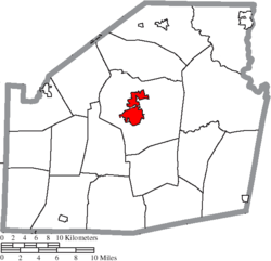
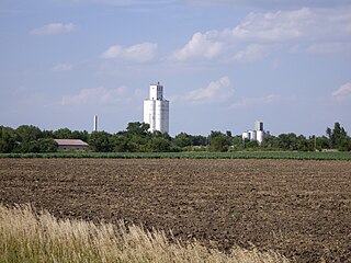
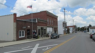
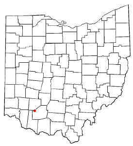
Highland County is a county located in the U.S. state of Ohio. As of the 2020 census, the population was 43,317. Its county seat is Hillsboro. The county is named for the topography which is hilly and divides the watersheds of the Little Miami and Scioto Rivers. Highland County was created on May 1, 1805, from land taken from Ross, Adams, and Clermont counties.
Hillsboro is a city in Henry County, Iowa, United States. The population was 163 at the time of the 2020 census.
Hillsboro is a city in Marion County, Kansas, United States. As of the 2020 census, the population of the city was 2,732. The city was named after John Hill, who homesteaded in the area in 1871. Hillsboro is home of Tabor College.
Lehigh is a city in Marion County, Kansas, United States. As of the 2020 census, the population of the city was 161. It is located between Hillsboro and Canton on the north side of U.S. Route 56.
Hillsboro is a city and county seat of Jefferson County, Missouri, United States. The population was 3,473 at the 2020 census, up from 2,821 in 2010.
St. Clairsville or Saint Clairsville is a city in and the county seat of Belmont County, Ohio, United States. The population was 5,096 at the 2020 census. It is part of the Wheeling metropolitan area.
Highland Heights is a city in Cuyahoga County, Ohio, United States. The city's population was 8,719 as of the 2020 census. An eastern suburb of Cleveland, it is part of the Cleveland metropolitan area.
Richmond Heights is a city in Cuyahoga County, Ohio, United States. The population was 10,801 at the 2020 census. A suburb of Cleveland, it is part of the Cleveland metropolitan area.
Deer Park is a city in Hamilton County, Ohio, United States. It is a suburb of Cincinnati. The population was 5,432 at the 2020 census.
Harrison is a city in western Hamilton County, Ohio, United States. The population was 12,563 at the 2020 census. It is part of the Cincinnati metropolitan area.
Cadiz is a village in and the county seat of Harrison County, Ohio, United States. The population was 3,051 at the 2020 census.
Highland is a village in Fairfield Township, Highland County, Ohio, United States. The population was 232 at the 2020 census.
Leesburg is a village in Highland County, Ohio, United States. The population was 1,273 at the 2020 census.
Sinking Spring is a village in Highland County, Ohio, United States. The population was 118 at the 2020 census.
Mingo Junction is a village in eastern Jefferson County, Ohio, United States, along the Ohio River. The population was 3,347 at the 2020 census. It is part of the Weirton–Steubenville metropolitan area.
Willoughby Hills is a city in Lake County, Ohio, United States, along the Chagrin River. The population was 10,019 at the 2020 census. A suburb of Cleveland, it is part of the Cleveland metropolitan area.
Hillsboro is a town in Pocahontas County, West Virginia, United States. The population was 232 at the 2020 census.
Lynchburg is a village in Clinton and Highland counties in the U.S. state of Ohio. The population was 1,510 at the 2020 census.
Hillsboro is a city in Vernon County, Wisconsin, United States. The population was 1,397 at the 2020 Census. The city is located within the Town of Hillsboro. Hillsboro is known as the Czech Capital of Wisconsin.