Buford, Ohio

Last updated

Buford, Ohio
OHMap-doton-Buford.png
Location of Buford, Ohio
Coordinates: 39°04′19″N83°50′21″W / 39.07194°N 83.83917°W / 39.07194; -83.83917
Country United States
State Ohio
County Highland
Township Clay
Area
[1]
  Total1.48 sq mi (3.84 km2)
  Land1.48 sq mi (3.84 km2)
  Water0.00 sq mi (0.00 km2)
Elevation
[2]
965 ft (294 m)
Population
 (2020)
  Total306
  Density206.34/sq mi (79.66/km2)
Time zone UTC-5 (Eastern (EST))
  Summer (DST) UTC-4 (EDT)
ZIP code
45171
Area code(s) 937, 326
FIPS code 39-10156 [3]
GNIS feature ID2628870 [2]

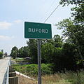
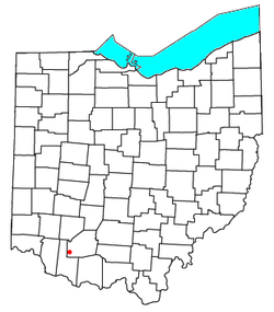
Buford is an unincorporated community and census-designated place in central Clay Township, Highland County, Ohio, United States. [2] The population was 306 at the 2020 census. It once had a post office, with the ZIP code 45110. [4] The current ZIP code 45171 is for nearby Sardinia.

Contents

History

Buford was platted in 1834, and named after the maiden name of the wife of a first settler. [5]

Geography

Buford lies in southwestern Highland County at the intersection of State Routes 134, 138, and 321. Route 134 leads north 12 miles (19 km) to Lynchburg and south 5 miles (8 km) to Sardinia. Route 138 leads northeast 15 miles (24 km) to Hillsboro, the Highland county seat, while Route 321 leads southeast 6 miles (10 km) to Mowrystown.

According to the United States Census Bureau, the Buford CDP has a total area of 1.48 square miles (3.84 km2), all of it recorded as land. [3]

Demographics

Historical population
CensusPop.Note
2020 306
U.S. Decennial Census [6]

Notable people

Related Research Articles

<span class="mw-page-title-main">Chesterland, Ohio</span> Census-designated place in Ohio, United States

Chesterland is a census-designated place (CDP) in Geauga County, Ohio, United States. As of the 2020 census, the CDP had a population of 7,074.

<span class="mw-page-title-main">East Liberty, Ohio</span> Census-designated place in Ohio, United States

East Liberty is an unincorporated community and census-designated place (CDP) located in Perry Township, Logan County, Ohio, United States. As of the 2020 census, it had a population of 371. It is located just off U.S. Route 33, 10 miles (16 km) east of Bellefontaine and 46 miles (74 km) northwest of Columbus. It has a post office with the ZIP code 43319.

<span class="mw-page-title-main">Lewistown, Ohio</span> Census-designated place in Ohio, United States

Lewistown is an unincorporated community and census-designated place (CDP) in central Washington Township, Logan County, Ohio, United States. As of the 2020 census, the population was 202.

<span class="mw-page-title-main">New Tripoli, Pennsylvania</span> Census-designated place in Pennsylvania, United States

New Tripoli is an unincorporated community and census-designated place (CDP) in Lynn Township in Lehigh County, Pennsylvania. As of the 2020 census, the population was 840. New Tripoli is part of the Lehigh Valley, which had a population of 861,899 and was the 68th-most populous metropolitan area in the U.S. as of the 2020 census.

Hopeland is a small unincorporated hamlet and census-designated place (CDP) that is located in Lancaster County in the south of the U.S. state of Pennsylvania in the United States. The hamlet's ZIP code is 17533.

<span class="mw-page-title-main">Georgetown, Lancaster County, Pennsylvania</span> Census-designated place in Pennsylvania, United States

Georgetown is an unincorporated community and census-designated place (CDP) in Bart Township, Lancaster County, Pennsylvania, United States. As of the 2010 census, the population was 1,022. Georgetown has a post office for P.O. boxes that is called Bart and has the ZIP code of 17503. Otherwise, the CDP is divided into three ZIP code areas for more distant communities.

<span class="mw-page-title-main">Tippecanoe, Ohio</span> Census-designated place in Ohio, United States

Tippecanoe is an unincorporated community and census-designated place (CDP) in central Washington Township, Harrison County, Ohio, United States. It is located along State Route 800 in the valley of Stillwater Creek, a north-flowing tributary of the Tuscarawas River. It had a post office until 2011 with the ZIP code 44699. The population was 83 at the 2020 census.

<span class="mw-page-title-main">New Haven, Huron County, Ohio</span> Census-designated place in Ohio, United States

New Haven is an unincorporated community and census-designated place (CDP) in central New Haven Township, Huron County, Ohio, United States. As of the 2020 census the population was 356. It has a post office with the ZIP code 44850. It lies at the intersection of U.S. Route 224 with State Routes 61 and 598.

<span class="mw-page-title-main">Collins, Ohio</span> Census-designated place in Ohio, United States

Collins is a census-designated place (CDP) in central Townsend Township, Huron County, Ohio, United States. As of the 2020 census the population of the CDP was 628. The CDP includes the unincorporated communities of Collins and East Townsend. Collins has a post office, with the ZIP code of 44826.

<span class="mw-page-title-main">Ridgeville Corners, Ohio</span> Census-designated place in Ohio, United States

Ridgeville Corners is an unincorporated community and census-designated place (CDP) in southern Ridgeville Township, Henry County, Ohio, United States. It has a post office with the ZIP code 43555. The population was 416 at the 2020 census.

<span class="mw-page-title-main">Miamitown, Ohio</span> Census-designated place in Ohio, United States

Miamitown is a census-designated place (CDP) in western Whitewater Township, Hamilton County, Ohio, United States. The population was 1,256 at the 2020 census. It has a post office with the ZIP code 45041.

<span class="mw-page-title-main">Camp Dennison, Ohio</span> Census-designated place in Ohio, United States

Camp Dennison is a census-designated place (CDP) just outside Indian Hill in southern Symmes Township, Hamilton County, Ohio, United States. It has a post office with the ZIP code 45111. The population was 384 at the 2020 census.

<span class="mw-page-title-main">East Rochester, Ohio</span> Census-designated place in Ohio, United States

East Rochester is an unincorporated community and census-designated place (CDP) in southern West Township, Columbiana County, Ohio, United States. The population was 224 as of the 2020 census. It lies along U.S. Route 30, and has a post office with the ZIP code 44625. It is a part of the Salem micropolitan area, about 20 miles (32 km) east of Canton.

<span class="mw-page-title-main">Sardis, Ohio</span> Census-designated place in Ohio, United States

Sardis is a census-designated place (CDP) in southeastern Lee Township, Monroe County, Ohio, United States. It is unincorporated, but has a post office with the ZIP code of 43946. As of the 2020 census, it had a population of 522.

<span class="mw-page-title-main">Smoketown, Pennsylvania</span> Census-designated place in Pennsylvania, United States

Smoketown is an unincorporated village and census-designated place (CDP) in East Lampeter Township, Lancaster County, Pennsylvania, United States. Also known as Smoke Town, it is served by the Smoketown Airport. As of the 2010 census, it had a population of 357.

Wakefield is an unincorporated community and census-designated place (CDP) within Fulton Township, Lancaster County, Pennsylvania, United States. As of the 2010 census, the population was 609. It is the largest community within the "Peach Bottom" ZIP code, with the area post office on Pennsylvania Route 272, just north of town.

<span class="mw-page-title-main">New Trenton, Indiana</span> Census-designated place in Indiana, United States

New Trenton is an unincorporated community and census-designated place (CDP) in Whitewater Township, Franklin County, Indiana. As of the 2010 census it had a population of 252. It has a ZIP code 47035.

<span class="mw-page-title-main">Nittany, Pennsylvania</span> Census designated place in Pennsylvania, United States

Nittany is an unincorporated community and census-designated place in Walker Township, Centre County, Pennsylvania, United States. As of the 2010 census, the population was 658.

<span class="mw-page-title-main">Marianne, Pennsylvania</span> Census designated place in Pennsylvania, United States

Marianne is a census-designated place located in Paint Township and Elk Township, Clarion County, in the U.S. state of Pennsylvania. The community is located at the intersections of Pennsylvania Route 66 and U.S. Route 322, approximately 1 mile (1.6 km) east of the borough of Shippenville and 3 miles (5 km) northwest of Clarion, the county seat. As of the 2010 census the population of Marianne was 1,167.

<span class="mw-page-title-main">Ohio State Route 321</span> State highway in Highland County, Ohio, US

State Route 321 is a short 9.07-mile (14.60 km) long state highway in southwestern Highland County, Ohio. The route connects SR 134 in Buford and US 62 with the village of Mowrystown.

References

  1. "ArcGIS REST Services Directory". United States Census Bureau. Retrieved September 20, 2022.
  2. 1 2 3 U.S. Geological Survey Geographic Names Information System: Buford, Ohio
  3. 1 2 "Geographic Identifiers: 2010 Census Summary File 1 (G001): Buford CDP, Ohio". American Factfinder. U.S. Census Bureau. Archived from the original on February 13, 2020. Retrieved January 3, 2018.
  4. USPS – Cities by ZIP Code Archived October 8, 2007, at the Wayback Machine
  5. Overman, William Daniel (1958). Ohio Town Names. Akron, OH: Atlantic Press. p. 21.
  6. "Census of Population and Housing". Census.gov. Retrieved June 4, 2016.
  7. Association of Graduates of the United States Military Academy (June 11, 1937). Sixty-Eighth Annual Report. Newburgh, NY: The Moore Printing Company. p. 145 via United States Military Academy Library.