Hunting Valley, Ohio

Last updated

Hunting Valley, Ohio
Shaker Boulevard near Chagrin River Road.jpg
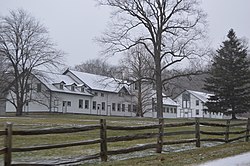
Halfred Farms, the former estate of Windsor T. White
Cuyahoga County Ohio incorporated and unincorporated areas Hunting Valley highlighted.svg
Location in Cuyahoga County and the state of Ohio.
Coordinates: 41°29′24″N81°24′44″W / 41.49000°N 81.41222°W / 41.49000; -81.41222
Country United States
State Ohio
Counties Cuyahoga, Geauga
Government
  MayorBruce Mavec (R) [1]
Area
[2]
  Total8.01 sq mi (20.75 km2)
  Land7.89 sq mi (20.44 km2)
  Water0.12 sq mi (0.31 km2)
Elevation
[3]
965 ft (294 m)
Population
 (2020)
  Total763
  Density96.68/sq mi (37.33/km2)
Time zone UTC-5 (Eastern (EST))
  Summer (DST) UTC-4 (EDT)
ZIP code
44022, 44040
Area code(s) 440, 216
FIPS code 39-36918 [4]
GNIS feature ID1085973 [3]
Website huntingvalley.net

Hunting Valley is a village in Cuyahoga and Geauga counties in the U.S. state of Ohio. The population was 763 as of the 2020 census. An eastern suburb of Cleveland, it is part of the Cleveland metropolitan area. In 2000, Hunting Valley was ranked the 6th highest-income place in the United States. It was the 17th highest-income place in 2010, but still the wealthiest locale in Ohio.[ citation needed ]

Contents

History

Hunting Valley is one of the five municipalities, along with Moreland Hills, Orange Village, Pepper Pike and Woodmere, that originally formed Orange Township, established in 1820. Orange Township was the birthplace of President James A. Garfield in 1831.

Roundwood Manor was built in 1923 by the railway barons the Van Sweringen brothers. [5] In 1924, Hunting Valley was incorporated as a village encompassing the northeast quadrant of the original Orange Township. Hunting Valley is also part of the Connecticut Western Reserve.

Geography

According to the United States Census Bureau, the village has a total area of 8.01 square miles (20.75 km2), of which 7.89 square miles (20.44 km2) is land and 0.12 square miles (0.31 km2) is water. [6] The village is almost entirely within Cuyahoga County limits, the exception being a small fraction on its easternmost edge, which is in neighboring Geauga County.

Demographics

Historical population
CensusPop.Note
1930 401
1940 374−6.7%
1950 47727.5%
1960 62931.9%
1970 79726.7%
1980 786−1.4%
1990 7991.7%
2000 735−8.0%
2010 707−3.8%
2020 7637.9%
U.S. Decennial Census [7]

2010 census

At the 2010 census there were 707 people, 277 households, and 216 families living in the village. The population density was 89.4 inhabitants per square mile (34.5/km2). There were 322 housing units at an average density of 40.8 per square mile (15.8/km2). The racial makeup of the village was 97.0% White, 0.6% African American, 1.1% Asian, 0.3% from other races, and 1.0% from two or more races. Hispanic or Latino of any race were 2.7%. [8]

Of the 277 households 26.7% had children under the age of 18 living with them, 72.9% were married couples living together, 2.2% had a female householder with no husband present, 2.9% had a male householder with no wife present, and 22.0% were non-families. 19.9% of households were one person and 12.3% were one person aged 65 or older. The average household size was 2.55 and the average family size was 2.90.

The median age in the village was 50.3 years. 23.1% of residents were under the age of 18; 5.8% were between the ages of 18 and 24; 11.4% were from 25 to 44; 33.5% were from 45 to 64; and 26.4% were 65 or older. The gender makeup of the village was 49.2% male and 50.8% female.

2000 census

At the 2000 census there were 735 people, 284 households, and 241 families living in the village. The population density was 92.1 inhabitants per square mile (35.6/km2). Of the 735 people, 728 of them are white. There were 317 housing units at an average density of 39.7 per square mile (15.3/km2). The racial makeup of the village was 99.05% White, 0.14% African American, 0.68% Asian, and 0.14% from two or more races. Hispanic or Latino of any race were 0.54%. [4] 17.4% were of English, 17.1% German, 11.0% Irish, 9.0% Italian, 5.7% American and 5.6% Russian ancestry according to Census 2000.

Of the 284 households 27.8% had children under the age of 18 living with them, 77.8% were married couples living together, 4.9% had a female householder with no husband present, and 15.1% were non-families. 13.7% of households were one person and 6.0% were one person aged 65 or older. The average household size was 2.59 and the average family size was 2.80.

The age distribution was 21.6% under the age of 18, 4.4% from 18 to 24, 14.4% from 25 to 44, 35.9% from 45 to 64, and 23.7% 65 or older. The median age was 51 years. For every 100 females there were 99.2 males. For every 100 females age 18 and over, there were 91.4 males.

The median household income was in excess of $200,000, as is the median family income . Males had a median income of over $100,000 versus $42,083 for females. The per capita income for the village was $144,281. About 2.1% of families and 2.3% of the population were below the poverty line, including 0.6% of those under age 18 and none of those age 65 or over.
Schools

Hunting Valley is served by the Orange City School System.

Hunting Valley is also home to the upper school campus of the college preparatory University School, and is a nearby community for other private schools.

Squire Valley View Farm, a research and recreational property belonging to Case Western Reserve University, is situated on 381 acres of land bequeathed to the school by the locally renowned Squire and Wade families in the early and mid 20th century.

Related Research Articles

<span class="mw-page-title-main">Trout Valley, Illinois</span> Village in Illinois, United States

Trout Valley is a village in McHenry County, Illinois, United States. It was incorporated as a village on March 19, 1996. Per the 2020 census, the population was 515.

<span class="mw-page-title-main">Maurice, Iowa</span> City in Iowa, United States

Maurice is a city in Sioux County, Iowa, United States, along the West Branch of the Floyd River. The population was 265 at the time of the 2020 census. It is home to the "Famous Maurice Fire Escape Slide" in the town park.

<span class="mw-page-title-main">Weston, Nebraska</span> Village in Saunder County, Nebraska, United States

Weston is a village in Saunders County, Nebraska, United States. The population was 250 at the 2020 census.

<span class="mw-page-title-main">Arcadia, Nebraska</span> Village in Valley County, Nebraska, United States

Arcadia is a village in Valley County, Nebraska, United States. The population was 311 at the 2010 census.

<span class="mw-page-title-main">Washington, Nebraska</span> Village in Washington County, Nebraska, United States

Washington is a village in Washington County, Nebraska, United States. The population was 129 at the 2020 census.

<span class="mw-page-title-main">Indian Point, Missouri</span> Village in Missouri, United States

Indian Point is a village in Stone County, Missouri, United States. The population was 550 at the 2020 census. It is part of the Branson, Missouri Micropolitan Statistical Area.

<span class="mw-page-title-main">Moreland Hills, Ohio</span> Village in Ohio, United States

Moreland Hills is a village in eastern Cuyahoga County, Ohio, United States. The population was 3,466 at the 2020 census. An eastern suburb of Cleveland, it is part of the Cleveland metropolitan area.

<span class="mw-page-title-main">Orange, Ohio</span> Village in Ohio, United States

Orange is a village in eastern Cuyahoga County, Ohio, United States. The population was 3,421 at the 2020 census. An affluent eastern suburb of Cleveland, it is part of the Cleveland metropolitan area.

<span class="mw-page-title-main">Valley View, Ohio</span> Village in Ohio, United States

Valley View is a village in Cuyahoga County, Ohio, United States. The population was 1,897 at the 2020 census. A suburb of Cleveland, it is a part of the Cleveland metropolitan area.

<span class="mw-page-title-main">Woodmere, Ohio</span> Village in Ohio, United States

Woodmere is a village in Cuyahoga County, Ohio, United States. As of the 2020 census, Woodmere had a population of 641 residents. An eastern suburb of Cleveland, it is part of the Cleveland metropolitan area.

<span class="mw-page-title-main">Spring Valley, Ohio</span> Village in Ohio, United States

Spring Valley is a village in Greene County, Ohio, United States. The population was 415 at the 2020 census. It is part of the Dayton Metropolitan Statistical Area.

<span class="mw-page-title-main">Pleasant City, Ohio</span> Village in Ohio, United States

Pleasant City is a village in Guernsey County, Ohio, United States. The population was 400 at the 2020 census.

<span class="mw-page-title-main">Indian Hill, Ohio</span> City in Ohio, United States

The Village of Indian Hill is a city in Hamilton County, Ohio, United States, and a suburb of the Greater Cincinnati area. The population was 6,087 at the 2020 census. Prior to 1970, Indian Hill was incorporated as a village, but under Ohio law became designated as a city once its population was verified as exceeding 5,000. The municipality then changed its name to add "Village", and legally it is known as "The City of The Village of Indian Hill". The Village of Indian Hill is served by the Indian Hill Exempted Village School District.

<span class="mw-page-title-main">Valley Hi, Ohio</span> Village in Ohio, United States

Valley Hi is a village in Logan County, Ohio, United States. The population was 228 at the 2020 census. The village is located nearby U.S. Route 33 and is about an hour northwest of Columbus. The village lies mostly in Jefferson Township, but its southernmost portion extends into Monroe Township.

<span class="mw-page-title-main">Thornville, Ohio</span> Village in Ohio, United States

Thornville is a village in Perry County, Ohio, United States. It is 20 miles (32 km) north of the county seat of New Lexington. The village had a population of 1,087 as of the 2020 census.

<span class="mw-page-title-main">Bainbridge, Ross County, Ohio</span> Village in Ohio, United States

Bainbridge is a village in Ross County, Ohio, United States, along Paint Creek. The population was 765 at the 2020 census.

<span class="mw-page-title-main">Orangeville, Ohio</span> Village in Ohio, United States

Orangeville is a village in eastern Trumbull County, Ohio, United States, along the state line with Pennsylvania. The population was 174 at the 2020 census. It is part of the Youngstown–Warren metropolitan area.

<span class="mw-page-title-main">Wilkesville, Ohio</span> Village in Ohio, United States

Wilkesville is a village in Vinton County, Ohio, United States. The population was 116 at the 2020 census.

<span class="mw-page-title-main">Valley Grove, West Virginia</span> Village in West Virginia, United States

Valley Grove is a village in Ohio County, West Virginia, United States. It is part of the Wheeling, West Virginia Metropolitan Statistical Area. The population was 275 at the 2020 census. The village was named from a nearby recreational area at a grove in a valley.

<span class="mw-page-title-main">Spring Valley, Wisconsin</span> Village in Wisconsin, United States

Spring Valley is a village in Pierce and St. Croix counties in Wisconsin, United States. The population was 1,401 at the 2020 census. Of those, 1,390 were in Pierce County and 11 in St. Croix County. The village is mostly within the Town of Spring Lake in Pierce County. Small parts also lie in the Town of Gilman, also in Pierce County, and the Town of Cady in St. Croix County.

References

  1. "2024 Elected Officials" . Retrieved August 1, 2024.
  2. "ArcGIS REST Services Directory". United States Census Bureau. Retrieved September 20, 2022.
  3. 1 2 U.S. Geological Survey Geographic Names Information System: Hunting Valley, Ohio
  4. 1 2 "U.S. Census website". United States Census Bureau . Retrieved January 31, 2008.
  5. ROUNDWOOD MANOR IN DAISY HILL
  6. "US Gazetteer files 2010". United States Census Bureau. Archived from the original on January 12, 2012. Retrieved January 6, 2013.
  7. "Census of Population and Housing". Census.gov. Retrieved June 4, 2015.
  8. "U.S. Census website". United States Census Bureau . Retrieved January 6, 2013.