Mayfield Heights, Ohio

Last updated

Mayfield Heights, Ohio
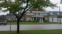
Mayfield City Hall - panoramio.jpg
Mayfield Heights City Hall
Motto: 
"A Vibrant Community"
Cuyahoga County Ohio incorporated and unincorporated areas Mayfield Heights highlighted.svg
Location in Cuyahoga County and the state of Ohio
Coordinates: 41°31′3″N81°27′21″W / 41.51750°N 81.45583°W / 41.51750; -81.45583
Country United States
State Ohio
County Cuyahoga
Founded1920
Incorporated1950
Government
   Mayor Anthony DiCicco (R) [1] [2]
Area
[3]
  Total4.18 sq mi (10.82 km2)
  Land4.17 sq mi (10.80 km2)
  Water0.01 sq mi (0.02 km2)
Elevation
[4]
1,086 ft (331 m)
Population
 (2020)
  Total20,351
  Density4,881.51/sq mi (1,884.87/km2)
Time zone UTC-5 (EST)
  Summer (DST) UTC-4 (EDT)
Zip code
44124 and 44143
Area code 440
FIPS code 39-48482 [5]
GNIS feature ID1056413 [4]
Website www.mayfieldheights.org

Mayfield Heights is a city in Cuyahoga County, Ohio, United States. The population was 20,351 at the 2020 census. An eastern suburb of Cleveland, it is part of the Cleveland metropolitan area.

Contents

History

Mausoleum at Knollwood Cemetery Mausoleum - Knollwood Cemetery.jpg
Mausoleum at Knollwood Cemetery

Mayfield Heights was initially built up as a streetcar suburb of Cleveland. [6] It was incorporated as a village in 1925 and as a city in 1951. [7] The city derives its name from Mayfield Township, now defunct. [8] One location in the city, the W.A. Thorp House, was listed on the National Register of Historic Places in 1978. [9]

The city has a large community of Italian Americans, including newly-arrived immigrants and those who migrated eastward along Mayfield Road from Little Italy on Cleveland's East Side. [10] Since the dissolution of the USSR in 1991, they have been joined by a significant number of immigrants from Russia and other former Soviet republics. [11] [12]

Geography

Mayfield Heights is located at 41°31′03″N81°27′21″W / 41.517402°N 81.455889°W / 41.517402; -81.455889 . [13]

According to the United States Census Bureau, the city has a total area of 4.18 square miles (10.83 km2), of which 4.17 square miles (10.80 km2) is land and 0.01 square miles (0.03 km2) is water. [14]

Demographics

Historical population
CensusPop.Note
1930 2,612
1940 2,6963.2%
1950 5,807115.4%
1960 13,478132.1%
1970 22,13964.3%
1980 21,550−2.7%
1990 19,847−7.9%
2000 19,386−2.3%
2010 19,155−1.2%
2020 20,3516.2%
2021 (est.)20,044−1.5%
Sources: [5] [15] [16] [17]

23.9% were of Italian, 14.5% German, 11.9% Irish, 7.4% Polish, 6.8% Russian, and 6.4% English ancestries. [18]

Languages

81.0% spoke English, 7.11% Russian, 4.10% Italian, and 1.03% Arabic as their first language. [19]

2010 census

As of the census [20] of 2010, there were 19,155 people, 9,662 households, and 4,884 families living in the city. The population density was 4,593.5 inhabitants per square mile (1,773.6/km2). There were 10,538 housing units at an average density of 2,527.1 per square mile (975.7/km2). The racial makeup of the city was 80.4% White, 10.3% African American, 0.1% Native American, 7.0% Asian, 0.5% from other races, and 1.7% from two or more races. Hispanic or Latino people of any race were 2.0% of the population.

There were 9,662 households, of which 21.2% had children under the age of 18 living with them, 36.0% were married couples living together, 11.2% had a female householder with no husband present, 3.3% had a male householder with no wife present, and 49.5% were non-families. 44.2% of all households were made up of individuals, and 20.5% had someone living alone who was 65 years of age or older. The average household size was 1.97 and the average family size was 2.75.

The median age in the city was 42.9 years. 17.6% of residents were under the age of 18; 7.2% were between the ages of 18 and 24; 27.6% were from 25 to 44; 23.9% were from 45 to 64; and 23.8% were 65 years of age or older. The gender makeup of the city was 45.3% male and 54.7% female.

Of the city's population over the age of 25, 38.3% hold a bachelor's degree or higher. [21]

2000 census

As of the census [5] of 2000, there were 19,386 people, 9,848 households, and 5,042 families living in the city. The population density was 4,596.1 inhabitants per square mile (1,774.6/km2). There were 10,461 housing units at an average density of 2,480.1 per square mile (957.6/km2). The racial makeup of the city was 91.85% White, 2.98% African American, 0.03% Native American, 4.03% Asian, 0.01% Pacific Islander, 0.18% from other races, and 0.93% from two or more races. Hispanic or Latino people of any race were 1.04% of the population.

There were 9,848 households, out of which 17.9% had children under the age of 18 living with them, 40.1% were married couples living together, 8.2% had a female householder with no husband present, and 48.8% were non-families. 44.5% of all households were made up of individuals, and 22.5% had someone living alone who was 65 years of age or older. The average household size was 1.95 and the average family size was 2.75.

In the city the population was spread out, with 16.1% under the age of 18, 6.6% from 18 to 24, 28.9% from 25 to 44, 20.8% from 45 to 64, and 27.6% who were 65 years of age or older. The median age was 44 years. For every 100 females, there were 82.2 males. For every 100 females age 18 and over, there were 78.9 males.

The median income for a household in the city was $37,236, and the median income for a family was $51,132. Males had a median income of $37,358 versus $29,118 for females. The per capita income for the city was $24,392. About 4.6% of families and 6.3% of the population were below the poverty line, including 6.3% of those under age 18 and 9.1% of those age 65 or over.

Schools

Mayfield Heights is a part of the Mayfield City School District, along with Highland Heights, Mayfield Village, and Gates Mills.

Notable people

Related Research Articles

<span class="mw-page-title-main">Bedford Heights, Ohio</span> City in Ohio, United States

Bedford Heights is a city in Cuyahoga County, Ohio, United States. The population was 11,020 at the 2020 census. A suburb of Cleveland, it is a part of the Cleveland metropolitan area.

<span class="mw-page-title-main">Brooklyn Heights, Ohio</span> Village in Ohio, United States

Brooklyn Heights is a village in Cuyahoga County, Ohio, United States. The population was 1,519 at the 2020 census. A suburb of Cleveland, it is a part of the Cleveland metropolitan area.

<span class="mw-page-title-main">Cleveland Heights, Ohio</span> City in Ohio, United States

Cleveland Heights is a city in Cuyahoga County, Ohio, United States. The population was 45,312 at the 2020 census. One of Cleveland's historical streetcar suburbs, it was founded as a village in 1903 and a city in 1921.

<span class="mw-page-title-main">Cuyahoga Heights, Ohio</span> Village in Ohio, United States

Cuyahoga Heights is a village in Cuyahoga County, Ohio, United States. The population was 573 at the 2020 census. A suburb of Cleveland, it is a part of the Cleveland metropolitan area.

<span class="mw-page-title-main">Garfield Heights, Ohio</span> City in Ohio, United States

Garfield Heights is a city in Cuyahoga County, Ohio, United States. The population was 29,781 at the time of the 2020 census. A suburb of Cleveland, it is a part of the Cleveland metropolitan area.

<span class="mw-page-title-main">Gates Mills, Ohio</span> Village in Ohio, United States

Gates Mills is a village in eastern Cuyahoga County, Ohio, United States. A suburb of Cleveland, it is part of the Cleveland metropolitan area. The population was 2,264 at the 2020 census.

<span class="mw-page-title-main">Highland Heights, Ohio</span> City in Ohio, United States

Highland Heights is a city in Cuyahoga County, Ohio, United States. The city's population was 8,719 as of the 2020 census. An eastern suburb of Cleveland, it is part of the Cleveland metropolitan area.

<span class="mw-page-title-main">Independence, Ohio</span> City in Ohio, United States

Independence is a city in Cuyahoga County, Ohio. As of the 2020 census, the city population was 7,584. A suburb of Cleveland, it is a part of the Cleveland metropolitan area.

<span class="mw-page-title-main">Lyndhurst, Ohio</span> City in Ohio, United States

Lyndhurst is a city in Cuyahoga County, Ohio, United States, and an eastern suburb of Cleveland. The population was 14,050 at the 2020 census. A small part of Lyndhurst was originally part of Mayfield Township.

<span class="mw-page-title-main">Maple Heights, Ohio</span> City in Ohio, United States

Maple Heights is a city in Cuyahoga County, Ohio, United States. It is a suburb of Cleveland. The population was 23,701 at the 2020 census.

<span class="mw-page-title-main">Mayfield, Ohio</span> Village in Ohio, United States

Mayfield is a village in eastern Cuyahoga County, Ohio, United States. A suburb of Cleveland, it is part of the Cleveland metropolitan area. The population was 3,356 at the 2020 census.

<span class="mw-page-title-main">Middleburg Heights, Ohio</span> City in Ohio, United States

Middleburg Heights is a city in Cuyahoga County, Ohio, United States. It is a suburb about 11 miles (18 km) southwest of downtown Cleveland. The population was 16,004 at the 2020 census.

<span class="mw-page-title-main">North Royalton, Ohio</span> City in Ohio, United States

North Royalton is a city in Cuyahoga County, Ohio, United States. It is a suburb of Cleveland. The population was 31,322 as of the 2020 Census. Originally incorporated as a village in 1927, it achieved the status of city in 1961.

<span class="mw-page-title-main">Parma Heights, Ohio</span> City in Ohio, United States

Parma Heights is a city in Cuyahoga County, Ohio, United States. The city's population was 20,863 as of the 2020 census. A suburb of Cleveland, it is a part of the Cleveland metropolitan area. Parma Heights is surrounded on the north, east and south by the larger city of Parma. The cities of Brook Park and Middleburg Heights form most of the western border.

<span class="mw-page-title-main">Pepper Pike, Ohio</span> City in Ohio, United States

Pepper Pike is a city in eastern Cuyahoga County, Ohio, United States. The population was 6,796 as of the 2020 census. A suburb of Cleveland, it is a part of the Cleveland metropolitan area.

<span class="mw-page-title-main">Richmond Heights, Ohio</span> City in Ohio, United States

Richmond Heights is a city in Cuyahoga County, Ohio, United States. The population was 10,801 at the 2020 census. A suburb of Cleveland, it is part of the Cleveland metropolitan area.

<span class="mw-page-title-main">University Heights, Ohio</span> City in Ohio, United States

University Heights is a city in Cuyahoga County, Ohio, United States. The population was 13,914 as of the 2020 Census. Located 8 miles (13 km) from downtown Cleveland, it is a suburb of the Cleveland metropolitan area.

<span class="mw-page-title-main">Warrensville Heights, Ohio</span> City in Ohio, United States

Warrensville Heights is a city in Cuyahoga County, Ohio, United States. It is an eastern suburb of Cleveland. The population was 13,789 at the 2020 census.

<span class="mw-page-title-main">Willoughby Hills, Ohio</span> City in Ohio, United States

Willoughby Hills is a city in Lake County, Ohio, United States, along the Chagrin River. The population was 10,019 at the 2020 census. A suburb of Cleveland, it is part of the Cleveland metropolitan area.

<span class="mw-page-title-main">Cuyahoga Falls, Ohio</span> City in Ohio, United States

Cuyahoga Falls is a city in Summit County, Ohio, United States. As of the 2020 census, the city population was 51,114. The second-largest city in Summit County, it is located directly north of Akron and is a suburb of the Akron metropolitan area. The city was founded in 1812 by William Wetmore and was originally named Manchester, but renamed for the Cuyahoga River and the series of waterfalls that run along the southern boundary of the city.

References

  1. Exner, Rich (November 16, 2013). "Democrats outnumber Republicans as mayors in Cuyahoga County, 39-14". Cleveland.com . Retrieved January 31, 2016.
  2. "Anthony DiCicco is new Mayfield Heights mayor". February 6, 2013. Retrieved September 5, 2016.
  3. "ArcGIS REST Services Directory". United States Census Bureau. Retrieved September 20, 2022.
  4. 1 2 U.S. Geological Survey Geographic Names Information System: Mayfield Heights, Ohio
  5. 1 2 3 "U.S. Census website". United States Census Bureau . Retrieved January 31, 2008.
  6. Morton, Marian J. (2005). Cleveland Heights. Arcadia Publishing. p. 7. ISBN   9780738533889.
  7. "History". City of Mayfield Heights. Archived from the original on October 14, 2011. Retrieved April 4, 2014.
  8. Overman, William Daniel (1958). Ohio Town Names. Akron, OH: Atlantic Press. p. 85.
  9. "National Register Information System". National Register of Historic Places . National Park Service. July 9, 2010.
  10. "Mayfield Heights". The Encyclopedia of Cleveland History. Case Western Reserve University . Retrieved May 14, 2020.
  11. "Russians". The Encyclopedia of Cleveland History. Case Western Reserve University . Retrieved January 18, 2020.
  12. "Soviet and Post-Soviet Immigration". The Encyclopedia of Cleveland History. Case Western Reserve University. October 7, 2019. Retrieved January 18, 2020.
  13. "US Gazetteer files: 2010, 2000, and 1990". United States Census Bureau. February 12, 2011. Retrieved April 23, 2011.
  14. "US Gazetteer files 2010". United States Census Bureau. Archived from the original on July 2, 2012. Retrieved January 6, 2013.
  15. "Number of Inhabitants: Ohio" (PDF). 18th Census of the United States. U.S. Census Bureau. 1960. Retrieved May 17, 2020.
  16. "Ohio: Population and Housing Unit Counts" (PDF). U.S. Census Bureau. Retrieved November 22, 2013.
  17. "Mayfield Heights city, Ohio". census.gov. Retrieved July 5, 2022.
  18. United States Census
  19. "Data Center Results". Archived from the original on June 19, 2006. Retrieved August 10, 2013.
  20. "U.S. Census website". United States Census Bureau . Retrieved January 6, 2013.
  21. "Population estimates, July 1, 2015, (V2015)". Archived from the original on September 5, 2015. Retrieved September 5, 2016.
  22. "Spotlight on Matt Prater". The Denver Post. October 1, 2009. Retrieved February 6, 2022.
  23. "Underwood, Lauren". History, Art & Archives. United States House of Representatives. Retrieved February 6, 2022. born in Mayfield Heights, Cuyahoga County, Ohio, October 4, 1986