Kermit, Texas

Last updated

Kermit, Texas
City
City of Kermit
County courthouse for Winkler County, near the New Mexico line in far-west Texas LCCN2014630676.tif
Winkler County Courthouse in Kermit
Nickname: 
K-Town [ citation needed ]
TXMap-doton-Kermit.PNG
Location of Kermit, Texas
Winkler County Kermit.svg
Coordinates: 31°51′14″N103°5′32″W / 31.85389°N 103.09222°W / 31.85389; -103.09222
CountryUnited States
State Texas
County Winkler
Incorporated1938
Government
  MayorDavid Holbrook [1]
  City ManagerFrankie Davis [2]
  City SecretaryDiana Franco [3]
  Chief of PoliceJaime Ramos [4]
Area
[5]
  Total2.52 sq mi (6.52 km2)
  Land2.52 sq mi (6.52 km2)
  Water0.00 sq mi (0.00 km2)
Elevation
2,861 ft (872 m)
Population
 (2020)
  Total6,267
  Density2,486.90/sq mi (995.26/km2)
Time zone UTC−6 (Central (CST))
  Summer (DST) UTC−5 (CDT)
ZIP code
79745
Area code 432
FIPS code 48-39004 [6]
GNIS feature ID1360598 [7]
Website www.kermittexas.us

Kermit is a city in and the county seat of Winkler County, Texas, United States. [8] The population was 6,267 at the 2020 census. [9] The city was named after Kermit Roosevelt following a visit by his father, President Theodore Roosevelt, to the county.

Contents

History

Old Winkler County Courthouse in Kermit, c. 1910 Winkler County Courthouse 1910.jpg
Old Winkler County Courthouse in Kermit, c. 1910

Establishment

Kermit began as a convenient supply center for the scattered ranches of the area and became the seat of Winkler County when the county was organized in 1910. The first public school and the post office opened the same year. The town's namesake, Kermit Roosevelt, once visited the T Bar Ranch in northern Winkler County to hunt antelope a few months before the town was named. In 1916, the county suffered a drought. Many homesteaders and ranchers were forced to leave. In 1924, only Ern Baird's family remained in the town. Only one student attended school in the county for five months of 1924. Only three houses and the courthouse were in use by 1926.

Discovery of oil

On July 16, 1926, however, oil was discovered in Hendrick oilfield, near Kermit, and the town experienced a boom. In 1927, a population of 1,000 was reported; by 1929 that number increased to 1,500. On March 4, 1929, the Texas-New Mexico Railway reached the town.

Great Depression and incorporation

The Great Depression had little effect on the city throughout much of the 1930s, but the population decreased significantly in the early 1930s, and both population and business figures rose at the end of the 1930s, when 2,700 residents and 180 businesses were listed. On February 15, 1938, residents voted to incorporate. During the 1940s, the oil boom caused real estate prices to double. Housing was scarce, and some people lived in tents. A bank was opened by 1945. The grade school had to be enlarged, and a hospital was built.
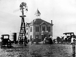
Oil boom days

View of Kermit Kermit Watertowers.jpg
View of Kermit

In the 1950s, the town continued to grow; housing additions were built. By 1960, the city had a population of 10,465 and 260 businesses, and additional growth estimated to be over 12,000 during the decade. Flooding became a problem because of the flat terrain, so new crown streets were constructed to solve the flooding problem, and more housing additions were built. The town moved the last working wooden derrick in the Permian Basin from Loving County to Pioneer Park in Kermit in 1966 as a symbol of the importance of the oil industry to the economy of Kermit and Winkler County. In the 1970s and 1980s, the population of Kermit bounced between 8,500 and 6,912, and the number of businesses moved between 200 and 116. Improvements were made in city services, and more housing additions were built.

On June 3, 1980, a 9-ft-wide (3 m) sinkhole opened on the property of Atlantic Richfield Company and got progressively larger. Within four days, it had become a tourist attraction, with a crater measuring 400 by 200 ft (122 by 61 m), and as much as 30 ft (9.1 m) deep. [11] The 1990 United States census set the population of Kermit at 6,875.

Geography

Kermit is located at 31°51′14″N103°5′32″W / 31.85389°N 103.09222°W / 31.85389; -103.09222 (31.853995, 103.092336). According to the United States Census Bureau, the city has a total area of 2.5 square miles (6.5 km2), all land. [12] The city is located in a semiarid region of the Permian Basin.

Climate

This area has a large amount of sunshine year round due to its stable descending air and high pressure. According to the Köppen climate classification system, Kermit has a hot arid climate, BWh on climate maps, [13] slightly too warm to be a cool arid climate (BWk) and slightly too dry for semi-arid classification.

Climate data for Winkler County Airport
MonthJanFebMarAprMayJunJulAugSepOctNovDecYear
Record high °F (°C)88
(31)
92
(33)
97
(36)
105
(41)
112
(44)
117
(47)
114
(46)
114
(46)
109
(43)
105
(41)
94
(34)
87
(31)
117
(47)
Average high °F (°C)59.6
(15.3)
64.9
(18.3)
73.1
(22.8)
82.2
(27.9)
90.0
(32.2)
96.9
(36.1)
96.9
(36.1)
95.8
(35.4)
89.4
(31.9)
80.5
(26.9)
68.5
(20.3)
61.1
(16.2)
80.1
(26.7)
Average low °F (°C)29.0
(−1.7)
33.1
(0.6)
40.5
(4.7)
49.5
(9.7)
59.0
(15.0)
68.0
(20.0)
70.8
(21.6)
69.5
(20.8)
62.7
(17.1)
51.0
(10.6)
37.5
(3.1)
30.0
(−1.1)
50.2
(10.1)
Record low °F (°C)−14
(−26)
−6
(−21)
9
(−13)
20
(−7)
29
(−2)
45
(7)
52
(11)
56
(13)
33
(1)
22
(−6)
0
(−18)
2
(−17)
−14
(−26)
Average precipitation inches (mm)0.47
(12)
0.40
(10)
0.49
(12)
0.64
(16)
1.31
(33)
1.47
(37)
1.68
(43)
1.43
(36)
1.62
(41)
1.50
(38)
0.45
(11)
0.44
(11)
11.71
(297)
Average snowfall inches (cm)1.3
(3.3)
0.5
(1.3)
0.3
(0.76)
0.4
(1.0)
0.0
(0.0)
0.0
(0.0)
0.0
(0.0)
0.3
(0.76)
0.4
(1.0)
3.1
(7.9)
Source: [14]

Demographics

Historical population
CensusPop.Note
1940 2,584
1950 6,912167.5%
1960 10,46551.4%
1970 7,884−24.7%
1980 8,0151.7%
1990 6,875−14.2%
2000 5,714−16.9%
2010 5,708−0.1%
2020 6,2679.8%

2020 census

Kermit racial composition [15]
(NH = Non-Hispanic) [lower-alpha 1]
RaceNumberPercentage
White (NH)1,82529.12%
Black or African American (NH)1151.84%
Native American or Alaska Native (NH)350.56%
Asian (NH)651.04%
Some Other Race (NH)60.1%
Mixed/Multi-Racial (NH)661.05%
Hispanic or Latino 4,15566.3%
Total6,267

As of the 2020 United States census, there were 6,267 people, 2,096 households, and 1,493 families residing in the city.

2010 census

At the 2010 census, 5,690 people resided in the city. At the 2000 census, [6] 5,714 people, 2,097 households and 1,585 families resided in the city. The population density was 2,288.3 inhabitants per square mile (883.5/km2). The 2,592 housing units averaged of 1,038.0 per square mile (400.3/km2). The racial makeup of the city was 72.65% White, 2.05% African American, 0.47% Native American, 0.25% Asian, 22.52% from other races, and 2.07% from two or more races. Hispanics or Latinos of any race were 47.83% of the population.

Of the 2,097 households, 38.7% had children under the age of 18 living with them, 61.3% were married couples living together, 10.0% had a female householder with no husband present, and 24.4% were not families. About 22.3% of all households were made up of individuals, and 12.0% had someone living alone who was 65 years of age or older. The average household size was 2.71 and the average family size was 3.18.

Age distribution was 29.9% under the age of 18, 8.9% from 18 to 24, 25.3% from 25 to 44, 20.7% from 45 to 64, and 15.2% who were 65 years of age or older. The median age was 35 years. For every 100 females, there were 95.0 males. For every 100 females age 18 and over, there were 91.2 males.

The median household income was $38,825, as opposed to $29,143 in 2000, and the median family income was $31,690. Males had a median income of $29,596 versus $18,380 for females. The per capita income for the city was $12,949. About 15.7% of families and 20.4% of the population were below the poverty line, including 27.8% of those under age 18 and 16.7% of those age 65 or over.

Education

Libraries

Schools

The City of Kermit is served by the Kermit Independent School District, [18] established in 1928, in a consolidation of two area school districts. [19] The district now has three campuses: Kermit Elementary (grades K–4), Kermit Junior High (grades 5–8), and Kermit High School (grades 9–12).

All of Winkler County is zoned to Odessa College. [20]

Newspapers

Hazardous waste site

In July, 2017, the U.S. Environmental Protection Agency gave Kermit a federal Superfund designation, marking it as one of the most hazardous waste sites in the country. The EPA said in a statement that a portion of the Santa Rosa Aquifer in Kermit has been added to the Superfund program's National Priorities List. The aquifer in the city west of Odessa has a contaminated groundwater plume a mile long and 1.5 miles wide. [21]

Notable people

Related Research Articles

<span class="mw-page-title-main">Winkler County, Texas</span> County in Texas, United States

Winkler County is a county in the U.S. state of Texas. As of the 2020 census, its population was 7,791. Its county seat is Kermit. The county was created in 1887 and organized in 1910. It is named for Clinton McKamy Winkler, a colonel in the Confederate Army.

<span class="mw-page-title-main">Reagan County, Texas</span> County in Texas, United States

Reagan County is a county on the Edwards Plateau in the U.S. state of Texas. As of the 2020 census, its population was 5,264. The county seat is Big Lake. The county is named after John Henninger Reagan (1818–1905), who was the postmaster general of the Confederate States and also a U.S. senator, U.S. representative, and first chairman of the Railroad Commission of Texas.

<span class="mw-page-title-main">Ector County, Texas</span> County in Texas, United States

Ector County is a county located in the U.S. state of Texas. In the 2020 census, its population was 165,171. Its county seat is Odessa. The county was founded in 1887 and organized in 1891. It is named for Matthew Ector, a Confederate general in the American Civil War.

<span class="mw-page-title-main">Crane County, Texas</span> County in Texas, United States

Crane County is a county located in the U.S. state of Texas. As of the 2020 census, its population was 4,675. The county seat is Crane. The county was created in 1887 and later organized in 1927. It was named for William Carey Crane, a president of Southern Baptist-affiliated Baylor University in Waco, Texas.

<span class="mw-page-title-main">Andrews County, Texas</span> County in Texas, United States

Andrews County is a county in the U.S. state of Texas. It is in West Texas and its county seat is Andrews.

<span class="mw-page-title-main">Andrews, Texas</span> City in Texas, United States

Andrews is the county seat of Andrews County in the Permian Basin of West Texas. Andrews sits to the far southwest within the Texas Panhandle's plains, about 30 miles east of New Mexico.

<span class="mw-page-title-main">Seymour, Texas</span> City in Texas, United States

Seymour is a city in and the county seat of Baylor County, Texas, United States. Its population was 2,575 as of the 2020 Census.

<span class="mw-page-title-main">Crane, Texas</span> City in Texas, United States

Crane is a city in and the county seat of Crane County, Texas, United States. Its population is about 3,680 as of 2018. An oil boomtown since the 1920s, Crane is still in the center of a prominent oil-producing region. It is the only significant town in sparsely populated Crane County, and contains the only post office in the county.

<span class="mw-page-title-main">Lamesa, Texas</span> City in Texas, United States

Lamesa is a city in and the county seat of Dawson County, Texas, United States. The population was 8,674 at the 2020 census, down from 9,952 at the 2000 census. Located south of Lubbock on the Llano Estacado, Lamesa was founded in 1903. Most of its economy is based on cotton farming. The Preston E. Smith prison unit, named for the former governor of Texas, is located just outside Lamesa.

<span class="mw-page-title-main">Sunray, Texas</span> City in Texas, United States

Sunray is a city in northeastern Moore County, Texas, United States. The population was 1,926 at the 2010 census.

<span class="mw-page-title-main">Iraan, Texas</span> City in Texas, United States

Iraan is a city in Pecos County, Texas, United States. Its population was 1,055 at the 2020 census. The city's name is an amalgamation of the first names of Ira and Ann Yates, owners of the ranch land upon which the town was built.

<span class="mw-page-title-main">Big Lake, Texas</span> City in Texas, United States

Big Lake is a small rural city in Reagan County, Texas, United States. As of the 2010 Census, the city population was 2,936. It is the county seat of Reagan County.

<span class="mw-page-title-main">Refugio, Texas</span> Town in Texas, United States

Refugio is a town in Refugio County, of which it is the county seat, in the U.S. state of Texas. The population was 2,890 as of the 2010 Census. Refugio is the birthplace of Baseball Hall of Fame member Nolan Ryan.

<span class="mw-page-title-main">Rankin, Texas</span> City in Texas, United States

Rankin is a city in Upton County, Texas, United States. Its population was 778 at the 2010 census. It is named after F.E. Rankin, a local rancher. It is the county seat of the thinly populated county; in 2010, only 3,355 people lived in the entire county, and McCamey was the only larger town. During the early 20th century, the town grew due to the discovery of oil in the nearby Yates Oil Field. However, following a second oil boom in the '80s the town saw a decline in its economy and population.

<span class="mw-page-title-main">Wink, Texas</span> City in Texas, United States

Wink is a city in Winkler County, Texas, United States. The population was 940 at the 2010 census. Wink was a temporary childhood home to singer and songwriter Roy Orbison, although he was born in Vernon, Texas. Orbison later described the major components of life in Wink as "football, oil fields, oil, grease and sand", and in later years expressed relief that he was able to leave the desolate town.

<span class="mw-page-title-main">Ackerly, Texas</span> City in Texas, United States

Ackerly is a city in Dawson and Martin Counties in the U.S. state of Texas. As of the 2020 Census, the population was 264. The Martin county portion of Ackerly is part of the Midland-Odessa metropolitan area.

<span class="mw-page-title-main">Odessa, Texas</span> City in Texas

Odessa is a city in and the county seat of Ector County, Texas, United States. It is located primarily in Ector County, although a small section of the city extends into Midland County.

<span class="mw-page-title-main">Happy, Texas</span> Town in Texas, United States

Happy is a town in Randall and Swisher Counties in the U.S. state of Texas. The population was 678 at the 2010 census. The Randall County portion of Happy is part of the Amarillo, Texas Metropolitan Statistical Area.

<span class="mw-page-title-main">Monahans, Texas</span> City in Texas, United States

Monahans is a city in and the county seat of Ward County, Texas, United States. A very small portion of the city extends into Winkler County. The population was 6,953 at the 2010 census. In 2018, the population was estimated at 7,669.

<span class="mw-page-title-main">Midland–Odessa</span> Metropolitan area in West Texas

Midland–Odessa is a metropolitan area located in The Texas Plains approximately half-way between El Paso and Fort Worth, Texas. This combined statistical area (CSA) is made up of two metropolitan statistical areas, and comprises three counties: Martin, Midland and Ector counties. The Midland–Odessa CSA is informally known as The Petroplex.

References

  1. City of Kermit Website Retrieved 2013-08-09
  2. City of Kermit Website Retrieved 2013-08-09
  3. City of Kermit Website Retrieved 2013-08-09
  4. City of Kermit Website Retrieved 2013-08-09
  5. "2019 U.S. Gazetteer Files". United States Census Bureau. Retrieved August 7, 2020.
  6. 1 2 "U.S. Census website". United States Census Bureau . Retrieved January 31, 2008.
  7. "US Board on Geographic Names". United States Geological Survey. October 25, 2007. Retrieved January 31, 2008.
  8. "Find a County". National Association of Counties. Archived from the original on May 31, 2011. Retrieved June 7, 2011.
  9. American Fact Finder [ dead link ]Retrieved 2011-02-26
  10. Wylene Kirk, "Early Post Offices and Towns in the Permian Basin Area", Texas Permian Historical Annual 1 (August 1961). Roger M. and Diana Davids Olien, Oil Booms (Lincoln: University of Nebraska Press, 1982). A History of Winkler County (Kermit, Texas: Winkler County Historical Commission, 1984). Julia Cauble Smith. Retrieved 2009-12-21
  11. "W. Texas Sinkhole Still Growing; Some Are Amused, Some Scared", Miami Herald, June 8, 1980, p3
  12. "US Gazetteer Files 2016-Places-Texas". US Census. Archived from the original on August 1, 2019. Retrieved January 7, 2017.
  13. "Climate Summary for Kermit, Texas". Weatehrbase.
  14. "NOWData — NOAA Online Weather Data". NOAA. Retrieved August 30, 2016.
  15. "Explore Census Data". data.census.gov. Retrieved May 19, 2022.
  16. https://www.census.gov/ [ not specific enough to verify ]
  17. "About the Hispanic Population and its Origin". www.census.gov. Retrieved May 18, 2022.
  18. "Kermit ISD Website". Archived from the original on September 7, 2008. Retrieved December 27, 2009.
  19. February 4, 1954 Article found in Winkler County News. Written by Ida Belle Riggins Retrieved 2011-02-27
  20. "Sec. 130.193. ODESSA COLLEGE DISTRICT SERVICE AREA".
  21. West Texas Groundwater Site Added to Federal Superfund List
  22. Texas Rodeo Hall of Fame Archived 2011-07-16 at the Wayback Machine Retrieved 2011-2-22
  23. The Internet Movie Database Retrieved 2011-2-21
  1. Note: the US Census treats Hispanic/Latino as an ethnic category. This table excludes Latinos from the racial categories and assigns them to a separate category. Hispanics/Latinos can be of any race. [16] [17]