The East Texas Yamboree is an annual event held in Gilmer.
History
Founded in 1846, the city's namesake is former Secretary of the NavyThomas Walker Gilmer. Gilmer is located on the Old Cherokee Trace, a trail used by the Cherokee Indians in their travels. To this day, arrowheads and other Native American artifacts can be found with little to no digging. Sam Houston, when he lived with the Cherokee, traveled the trace through here. The location of Gilmer was determined by a flood on Little Cypress Creek. First located near the creek, residents decided to change locations because of frequent floods.
In 1919, Chilton Jennings, a 28-year-old African American man, was lynched in Gilmer’s town square by a mob of about 1,000 White residents.[5][6]
As of the 2020 United States census, 4,843 people, 1,778 households, and 987 families were residing in the city.
As of the census[3] of 2000, 4,799 people, 1,926 households, and 1,300 families resided in the city. The population density was 1,038.5 inhabitants per square mile (401.0/km2). The 2,214 housing units averaged 479.1 per mi2 (185.0/km2). The racial makeup of the city was 75.91% White, 20.23% African American, 0.35% Native American, 0.08% Asian, 0.02% Pacific Islander, 1.90% from other races, and 1.50% from two or more races. Hispanics or Latinos of any race were 4.42% of the population.
Of the 1,926 households, 30.1% had children under 18 living with them, 46.2% were married couples living together, 17.7% had a female householder with no husband present, and 32.5% were not families. About 29.9% of all households were made up of individuals, and 17.3% had someone living alone who was 65 or older. The average household size was 2.37, and the average family size was 2.93.
In the city, the population was distributed as 25.3% under 18, 7.8% from 18 to 24, 23.5% from 25 to 44, 21.6% from 45 to 64, and 21.8% who were 65 or older. The median age was 40 years. For every 100 females, there were 83.4 males. For every 100 females 18 and over, there were 76.3 males.
The median income for a household in the city was $28,487 and for a family was $39,688. Males had a median income of $32,437 versus $17,910 for females. The per capita income for the city was $16,823. About 15.9% of families and 19.1% of the population were below the poverty line, including 26.5% of those under the age of 18 and 21.0% of those 65 and older.
Arts and culture
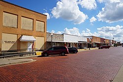
US-271 is the main highway in GilmerDowntown Gilmer
Annual events
The East Texas Yamboree is a celebration of the sweet potato, locally known as the yam. Established in 1935, it is one of the oldest continuous festivals in Texas, attracting over 100,000 visitors each year.[14][15] Events include a pageant, carnival, parades, a dance, livestock shows, a car show, and contests.[14][16]
The Upshur County Juneteenth celebration has featured a parade, live music, a car and tractor show, soul food contests, children's activities, vendor booths, and community unity programming.[17][18]
Charles F. Baird, a former justice of the Texas Court of Criminal Appeals and former judge, Travis County District Court, he is the only judge in Texas history to preside over the exoneration of a deceased individual; he was longtime criminal-justice reform advocate.
The Michelle Shocked song "Memories of East Texas" recalls her experiences growing up in Gilmer.[21]
Notes
↑Note: the US Census treats Hispanic/Latino as an ethnic category. This table excludes Latinos from the racial categories and assigns them to a separate category. Hispanics/Latinos can be of any race.[12][13]
↑"Find a County". National Association of Counties. Archived from the original on May 31, 2011. Retrieved June 7, 2011.
↑"Lynching of Chilton Jennings". Lynching in Texas. Texas After Violence Project. February 14, 2018. Archived from the original on November 14, 2023. Retrieved September 24, 2024.
This page is based on this Wikipedia article Text is available under the CC BY-SA 4.0 license; additional terms may apply. Images, videos and audio are available under their respective licenses.