Ore City, Texas

Last updated

Ore City, Texas
Nickname: 
"City on the Iron Hill"
TXMap-doton-OreCity.PNG
Upshur County OreCity.svg
Coordinates: 32°48′3″N94°43′3″W / 32.80083°N 94.71750°W / 32.80083; -94.71750
Country United States
State Texas
County Upshur
Government
  MayorGale Weir
Area
[1]
  Total2.18 sq mi (5.65 km2)
  Land2.16 sq mi (5.59 km2)
  Water0.02 sq mi (0.06 km2)
Elevation
328 ft (100 m)
Population
 (2020)
  Total1,108
  Density568.52/sq mi (219.56/km2)
Time zone Central (CST)
ZIP code
75683
Area code(s) 430, 903
FIPS code 48-54216 [2]
GNIS feature ID1343313 [3]

Ore City is a city in Upshur County, Texas, United States. The population was 1,108 at the 2020 census.

Contents

Geography

Ore City is located at 32°48′3″N94°43′3″W / 32.80083°N 94.71750°W / 32.80083; -94.71750 (32.800770, –94.717446). [4] It is situated about 13 miles northeast of Gilmer at the junction of U.S. Highway 259 and FM 450. [5]

According to the United States Census Bureau, the city has a total area of 2.3 mi2 (5.9 km2), of which 2.3 mi2 (5.9 km2) are land and 0.04 mi2 (0.1 km2) (0.88%) is water.

History

Originally part of the William Murray League, the area was first settled in the early 1850s by a group from Haywood County, Tennessee. [6] They immediately started The Murray League Methodist Episcopal Church, South as well as the Murray League Institute. After the Civil War, rich iron ore deposits were discovered in the area and ore was mined sporadically from the 1860s through 1900. [5]

Around 1910, a commercial company led by Colonel L.P. Featherstone was formed to mine ore in the area. He persuaded the Santa Fe line to finance a rail link with Port Bolivar. [7] Land for a new city was purchased and platted into streets and lots around 1911. The town was given the name Ore City and a post office was established soon after. By 1914, 30 miles of the line known as the Port Bolivar Iron Ore Railway had been built, connecting Ore City with Longview. The newly founded community had an estimated population of 400. Further construction on the railroad line was halted by the outbreak of World War I. Colonel Featherstone's company went into bankruptcy and the rail line was abandoned in 1927. [5] Ore City survived and by 1936, around 500 people lived in the community. During World War II, the federal government built a steel plant 10 miles north of Ore City to mine the same ore that previously brought Colonel Featherstone to the area. The plant was completed just as the war ended and was sold to a Texas group as surplus property. They operated it as the Lone Star Steel Company. [7]

Ore City was incorporated in the early 1950s. At that time, the number of residents had fallen to 385. [5] [7] Growth resumed in the mid-1960s and by 1976, Ore City had a population of 900, with 34 businesses operating in the city. More than 1,000 people lived in the city by 2000.

Demographics

Historical population
CensusPop.Note
1960 819
1970 8301.3%
1980 1,05026.5%
1990 898−14.5%
2000 1,10623.2%
2010 1,1443.4%
2020 1,108−3.1%
U.S. Decennial Census [8]
Ore City racial composition as of 2020 [9]
(NH = Non-Hispanic) [lower-alpha 1]
RaceNumberPercentage
White (NH)75868.41%
Black or African American (NH)676.05%
Native American or Alaska Native (NH)201.81%
Asian (NH)60.54%
Mixed/Multi-Racial (NH)665.96%
Hispanic or Latino 19117.24%
Total1,108

As of the 2020 United States census, there were 1,106 people, 350 households, and 252 families residing in the city.

Twenty years earlier, in the census [2] of 2000, 1,106 people, 403 households, and 295 families resided there. At that time the population density was 490.4 inhabitants per square mile (189.3/km2). The 432 housing units averaged 191.5 per square mile (73.8/km2). Of the 403 households, 37.2% had children under the age of 18 living with them, 57.3% were married couples living together, 13.4% had a female householder with no husband present, and 26.6% were not families. About 22.6% of all households were made up of individuals, and 10.9% had someone living alone who was 65 years of age or older. The average household size was 2.74 and the average family size was 3.23. In the city, the population was distributed as 31.8% under the age of 18, 8.7% from 18 to 24, 28.0% from 25 to 44, 18.1% from 45 to 64, and 13.4% who were 65 years of age or older. The median age was 32 years. For every 100 females, there were 89.1 males. For every 100 females age 18 and over, there were 86.6 males. The median income for a household in the city was $33,542, and for a family was $37,750. Males had a median income of $28,250 versus $18,333 for females. The per capita income for the city was $15,997. About 17.2% of families and 22.4% of the population were below the poverty line, including 32.5% of those under age 18 and 18.0% of those age 65 or over.

Education

Ore City is served by the Ore City Independent School District.

Notable people

Related Research Articles

<span class="mw-page-title-main">Upshur County, West Virginia</span> County in West Virginia, United States

Upshur County is a county in the U.S. state of West Virginia. As of the 2020 census, the population was 23,816. Its county seat is Buckhannon. The county was formed in 1851 from Randolph, Barbour, and Lewis counties and named for Abel Parker Upshur, a distinguished statesman and jurist of Virginia. Upshur served as United States Secretary of State and Secretary of the Navy under President John Tyler.

<span class="mw-page-title-main">Upshur County, Texas</span> County in Texas, United States

Upshur County is a county located in the eastern part of the U.S. state of Texas. As of the 2020 census, the population was 40,892. The county seat is Gilmer. The county is named for Abel P. Upshur, who was U.S. Secretary of State during President John Tyler's administration.

<span class="mw-page-title-main">Rusk County, Texas</span> County in Texas, United States

Rusk County is a county located in Texas. As of the 2020 census, its population was 52,214. Its county seat is Henderson. The county is named for Thomas Jefferson Rusk, a secretary of war of the Republic of Texas.

<span class="mw-page-title-main">Hopkins County, Texas</span> County in Texas, United States

Hopkins County is a county located in the U.S. state of Texas. As of the 2020 census, its population was 36,787. Its county seat is Sulphur Springs. Hopkins County is named for the family of David Hopkins, an early settler in the area. Hopkins County comprises the Sulphur Springs, TX Micropolitan Statistical Area. Hopkins County was once known as the Dairy Capital of Texas. Although dairy farms declined in the area in the late 1990s there are still a number of these located there. The Southwest Dairy Museum is located in Sulphur Springs.

<span class="mw-page-title-main">Harrison County, Texas</span> County in Texas, United States

Harrison County is a county on the eastern border of the U.S. state of Texas. As of the 2020 United States census, its population was 68,839. The county seat is Marshall. The county was created in 1839 and organized in 1842. It is named for Jonas Harrison, a lawyer and Texas revolutionary.

<span class="mw-page-title-main">Gregg County, Texas</span> County in Texas, United States

Gregg County is a county located in the eastern part of the U.S. state of Texas. As of the 2020 census, its population was 124,239. Its county seat is Longview. The county is named after John Gregg, a Confederate general killed in action during the American Civil War.

<span class="mw-page-title-main">Highfill, Arkansas</span> Town in Arkansas, United States

Highfill is a town in Benton County, Arkansas, United States. The population was 1,587 as of the 2020 census. It is home to the Northwest Arkansas National Airport, which serves all of the Northwest Arkansas region. In September 2023, officials of the airport voted to detach itself from the city over taxing and public service disputes.

<span class="mw-page-title-main">Ogden, Arkansas</span> City in Arkansas, United States

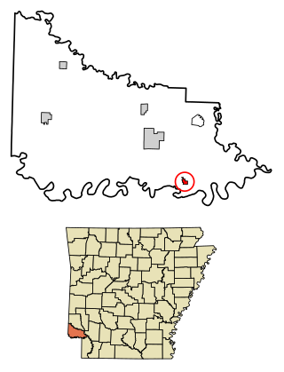
Ogden is a city in Little River County, Arkansas, United States. The population was 180 at the 2010 census, down from 214 at the 2000 census.

<span class="mw-page-title-main">Winton, Minnesota</span> City in Minnesota, United States

Winton is a city in Saint Louis County, Minnesota, United States. The population was 172 at the 2010 census. The city is home to a small hydroelectric dam on the edge of Garden Lake, one of 11 stations owned by Minnesota Power.

<span class="mw-page-title-main">Shark River Hills, New Jersey</span> Populated place in Monmouth County, New Jersey, US

Shark River Hills is an unincorporated community and census-designated place (CDP) within Neptune Township, in Monmouth County, in the U.S. state of New Jersey. As of the 2010 United States Census, the CDP's population was 3,697.

<span class="mw-page-title-main">Rotan, Texas</span> City in Texas, United States

Rotan is a city in Fisher County, Texas, United States. The population was 1,508 at the 2010 census, down from 1,611 at the 2000 census.

<span class="mw-page-title-main">Liberty City, Texas</span> Census-designated place in Texas, United States

Liberty City is a census-designated place (CDP) in Gregg County, Texas, United States. The population was 2,721 at the 2020 census, an increase over the figure of 2,351 tabulated in 2010.

<span class="mw-page-title-main">Agua Dulce, Nueces County, Texas</span> City in Texas, United States

Agua Dulce is a city in Nueces County, in the U.S. state of Texas. It is located on the Texas Mexican Railway at the intersection of State Highway 44 and Farm to Market Road 70 in west-central Nueces County. The name, Spanish for "sweet water", refers to a nearby creek. A town in Texas, Sweetwater in Nolan County in West Texas, uses the English name.

<span class="mw-page-title-main">East Mountain, Texas</span> City in Texas, United States

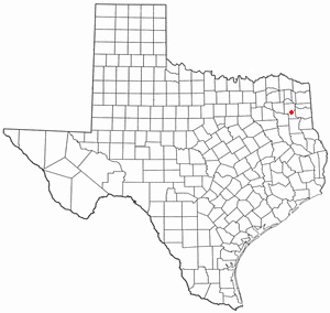
East Mountain is a city in Upshur and Gregg counties, Texas, United States. The population was 899 at the 2020 census, an increase over the figure of 797 tabulated in 2010.

<span class="mw-page-title-main">Gilmer, Texas</span> City in Texas, United States

Gilmer is a city in, and the county seat of, Upshur County, Texas, United States. It is best known for being the home of the East Texas Yamboree and the birthplace of popular music singers Don Henley of the Eagles band and Johnny Mathis, as well as blues musician Freddie King. Its population was 4,843 at the 2020 census.

<span class="mw-page-title-main">Union Grove, Texas</span> City in Texas, United States

Union Grove is a city in Upshur County, Texas, United States. The population was 357 at the 2010 census.

<span class="mw-page-title-main">Little Suamico, Wisconsin</span> Town in Wisconsin, United States

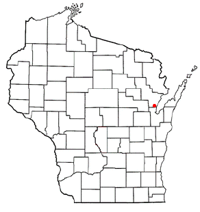
Little Suamico is a town in Oconto County, Wisconsin, United States. The population was 5536 at the 2020 census.

<span class="mw-page-title-main">Clarksville City, Texas</span> City in Texas, United States

Clarksville City is a city in Gregg and Upshur counties in the U.S. state of Texas. The population was 780 at the 2020 census.

<span class="mw-page-title-main">Gladewater, Texas</span> City in Texas, United States

Gladewater is a city in Gregg and Upshur counties in the U.S. state of Texas with a 2020 census population of 6,134.

<span class="mw-page-title-main">Warren City, Texas</span> City in Texas, United States

Warren City is a city in Gregg and Upshur counties in the U.S. state of Texas. The population was 319 at the 2020 U.S. census.

References

  1. "2019 U.S. Gazetteer Files". United States Census Bureau. Retrieved August 7, 2020.
  2. 1 2 "U.S. Census website". United States Census Bureau . Retrieved January 31, 2008.
  3. "US Board on Geographic Names". United States Geological Survey. October 25, 2007. Retrieved January 31, 2008.
  4. "US Gazetteer files: 2010, 2000, and 1990". United States Census Bureau. February 12, 2011. Retrieved April 23, 2011.
  5. 1 2 3 4 "Ore City, Texas". The Handbook of Texas online. Retrieved July 12, 2009.
  6. "Ore City Cemetery Index". Upshur County, TXGenWeb Project. Retrieved July 12, 2009.
  7. 1 2 3 "Brief History of Murray League and Ore City". David Williamson. Retrieved July 12, 2009.
  8. "Census of Population and Housing". Census.gov. Retrieved June 4, 2015.
  9. "Explore Census Data". data.census.gov. Retrieved May 25, 2022.
  10. https://www.census.gov/ [ not specific enough to verify ]
  11. "About the Hispanic Population and its Origin". www.census.gov. Retrieved May 18, 2022.
  12. Ziobro, Melissa. "Dr. Walter McAfee: Camp Evans Mathematician, Scholar, and Scientist". This Day in Monmouth County History. Monmouth Timeline. Retrieved February 22, 2022.
  1. Note: the US Census treats Hispanic/Latino as an ethnic category. This table excludes Latinos from the racial categories and assigns them to a separate category. Hispanics/Latinos can be of any race. [10] [11]