Holly Grove is a city in Monroe County, Arkansas, United States. As of the 2020 census, the city population was 460, down from 602 in 2010.

Haskell is a city in Saline County, Arkansas, United States. The population was 3,990 at the 2010 census. It is part of the Little Rock–North Little Rock–Conway Metropolitan Statistical Area.
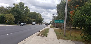
Spring Grove is a town in Wayne Township, Wayne County, in the U.S. state of Indiana. The population was 344 at the 2010 census.

Buck Grove is a city in Crawford County, Iowa, United States. The population was 34 at the 2020 census.

Thor is a town in Norway Township, Humboldt County, Iowa, United States. The population was 181 at the time of the 2020 census.

Council Grove is a city and county seat in Morris County, Kansas, United States. As of the 2020 census, the population of the city was 2,140. It was named after an agreement between American settlers and the Osage Nation allowing settlers' wagon trains to pass westward through the area on the Santa Fe Trail. Pioneers gathered at a grove of trees so that wagons could band together for their trip west.

Clarks Grove is a city in Freeborn County, Minnesota, United States. The population was 706 at the 2010 census.

Pilot Grove is a city in the Pilot Grove Township in northern Cooper County, Missouri, United States. The population was 768 at the 2010 census.

Meire Grove is a city in Stearns County, Minnesota, United States. The population was 179 at the 2010 census. It is part of the St. Cloud Metropolitan Statistical Area.

East Union Township is a township in Schuylkill County, Pennsylvania, United States. The population was 1,648 at the 2020 census.

Orange Grove is a city in Jim Wells County, Texas, United States. The population was 1,165 at the 2020 census.

Westdale is a census-designated place (CDP) in Jim Wells County, Texas, United States. The population was 325 at the 2020 census, up from 372 at the 2010 census.

Oak Grove is a town in Kaufman County, Texas, United States. The population was 617 at the 2020 census.

Plum Grove is a city in Liberty County, Texas, United States. The population was 1,245 at the 2020 census.

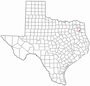
Barry is a city in Navarro County, in the U.S. state of Texas. The population was 220 at the 2020 census.
East Mountain is a city in Upshur and Gregg counties, Texas, United States. The population was 899 at the 2020 census, an increase over the figure of 797 tabulated in 2010.

Valley Grove is a village in Ohio County, West Virginia, United States. It is part of the Wheeling, West Virginia Metropolitan Statistical Area. The population was 275 at the 2020 census. The village was named from a nearby recreational area at a grove in a valley.

Pine Grove is a town in Wetzel County, West Virginia, United States. The population was 363 at the 2020 census. The community was named for a grove of pine trees near the original town site.

Blooming Grove is a town in Dane County, Wisconsin, United States. The population was 1,768 at the 2000 census. The unincorporated community of Hope is located partially within Blooming Grove. Although once much larger, currently the town of Blooming Grove consists of a few scattered neighborhoods and individual properties broken into discontinuous sections by the cities of Madison and Monona. Blooming Grove is set to be dissolved and annexed into the city of Madison by 2027.

Union Grove is a village in Racine County, Wisconsin, United States. The population was 4,806 at the 2020 census.