Brady, Texas

Last updated

Brady, Texas
Brady Texas City Hall 2019.jpg
Brady City Hall
Nickname: 
The Heart of Texas
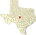
McCulloch County Brady.svg
Location of Brady, Texas
Coordinates: 31°7′56″N99°20′29″W / 31.13222°N 99.34139°W / 31.13222; -99.34139
Country United States
State Texas
County McCulloch
Area
[1]
  Total11.44 sq mi (29.63 km2)
  Land8.94 sq mi (23.16 km2)
  Water2.50 sq mi (6.47 km2)
Elevation
1,677 ft (511 m)
Population
 (2020)
  Total5,118
Time zone UTC-6 (Central (CST))
  Summer (DST) UTC-5 (CDT)
ZIP code
76825
Area code 325
FIPS code 48-09916 [2]
GNIS feature ID1352814 [3]
Website www.bradytx.us

Brady is a city in McCulloch County, Texas, United States. Brady refers to itself as the "Heart of Texas", as it is the city closest to the geographical center of the state, which is about 15 miles northeast of Brady. [4] Its population was 5,118 at the 2020 census. It is the county seat of McCulloch County. [5]

Contents

Geography

According to the United States Census Bureau, Brady has a total area of 11.5 square miles (30 km2), of which 9.2 sq mi (24 km2) are land and 2.3 sq mi (6.0 km2) (20.16%) are covered by water.

Major highways

Climate

The climate in this area is characterized by hot, humid summers and generally mild to cool winters. According to the Köppen climate classification, Brady has a humid subtropical climate, Cfa on climate maps. [6]

Climate data for Brady, Texas (1991–2020 normals, extremes 1893–1897, 1911–1913, 1937–present)
MonthJanFebMarAprMayJunJulAugSepOctNovDecYear
Record high °F (°C)91
(33)
99
(37)
97
(36)
102
(39)
107
(42)
110
(43)
110
(43)
108
(42)
109
(43)
103
(39)
92
(33)
91
(33)
110
(43)
Mean daily maximum °F (°C)58.4
(14.7)
62.4
(16.9)
69.7
(20.9)
77.2
(25.1)
83.6
(28.7)
90.0
(32.2)
93.2
(34.0)
93.7
(34.3)
86.8
(30.4)
78.4
(25.8)
67.4
(19.7)
59.6
(15.3)
76.7
(24.8)
Daily mean °F (°C)46.9
(8.3)
50.6
(10.3)
58.0
(14.4)
65.2
(18.4)
73.1
(22.8)
79.6
(26.4)
82.5
(28.1)
82.7
(28.2)
76.0
(24.4)
66.5
(19.2)
56.1
(13.4)
48.2
(9.0)
65.5
(18.6)
Mean daily minimum °F (°C)35.3
(1.8)
38.9
(3.8)
46.3
(7.9)
53.1
(11.7)
62.6
(17.0)
69.2
(20.7)
71.8
(22.1)
71.6
(22.0)
65.2
(18.4)
54.6
(12.6)
44.7
(7.1)
36.8
(2.7)
54.2
(12.3)
Record low °F (°C)0
(−18)
1
(−17)
7
(−14)
26
(−3)
37
(3)
47
(8)
54
(12)
50
(10)
33
(1)
23
(−5)
10
(−12)
−2
(−19)
−2
(−19)
Average precipitation inches (mm)1.33
(34)
1.71
(43)
2.33
(59)
2.05
(52)
3.79
(96)
2.88
(73)
2.11
(54)
2.21
(56)
2.76
(70)
2.71
(69)
1.87
(47)
1.63
(41)
27.38
(695)
Average snowfall inches (cm)0.0
(0.0)
0.1
(0.25)
0.0
(0.0)
0.0
(0.0)
0.0
(0.0)
0.0
(0.0)
0.0
(0.0)
0.0
(0.0)
0.0
(0.0)
0.0
(0.0)
0.1
(0.25)
0.1
(0.25)
0.3
(0.76)
Average precipitation days (≥ 0.01 in)5.85.66.25.47.65.74.55.25.76.05.66.169.4
Average snowy days (≥ 0.1 in)0.00.10.00.00.00.00.00.00.00.00.10.10.3
Source: NOAA [7] [8]

Demographics

Historical population
CensusPop.Note
1880 115
1890 560387.0%
1910 2,669
1920 2,197−17.7%
1930 3,98381.3%
1940 5,00225.6%
1950 5,94418.8%
1960 5,338−10.2%
1970 5,5574.1%
1980 5,9697.4%
1990 5,946−0.4%
2000 5,523−7.1%
2010 5,5280.1%
2020 5,118−7.4%
U.S. Decennial Census [9]

2020 census

Brady racial composition [10]
(NH = Non-Hispanic) [lower-alpha 1]
RaceNumberPercentage
White (NH)2,93057.25%
Black or African American (NH)841.64%
Native American or Alaska Native (NH)70.14%
Asian (NH)370.72%
Some Other Race (NH)90.18%
Mixed/Multi-Racial (NH)1242.42%
Hispanic or Latino 1,92737.65%
Total5,118

As of the 2020 United States census, there were 5,118 people, 1,978 households, and 1,225 families residing in the city.

2000 census

As of the census [2] of 2000, 5,523 people, 2,181 households, and 1,448 families resided in the city. The population density was 601.1 inhabitants per square mile (232.1/km2). The 2,603 housing units averaged 283.3 per square mile (109.4/km2). The racial makeup of the city was 59.6% White, 2.2% Black, 0.3% Native American, 0.4% Asian, 0.1% from other races, and 0.6% from two or more races. Hispanics or Latinos of any race were 36.7% of the population.

Of the 2,181 households, 32.6% had children under the age of 18 living with them, 50.7% were married couples living together, 12.2% had a female householder with no husband present, and 33.6% were not families. About 31.3% of all households were made up of individuals, and 17.7% had someone living alone who was 65 years of age or older. The average household size was 2.48 and the average family size was 3.11.

In the city, the population was distributed as 28.4% under the age of 18, 7.6% from 18 to 24, 23.5% from 25 to 44, 21.2% from 45 to 64, and 19.3% who were 65 years of age or older. The median age was 37 years. For every 100 females, there were 85.0 males. For every 100 females age 18 and over, there were 80.2 males.

The median income for a household in the city was $22,961, and for a family was $28,701. Males had a median income of $25,498 versus $17,289 for females. The per capita income for the city was $12,607. About 18.7% of families and 23.5% of the population were below the poverty line, including 27.7% of those under age 18 and 22.1% of those age 65 or over.

History

When the area was settled in the 1870s, the community was named Brady City after Brady Creek, which runs through town. The name was shortened to Brady when the town was incorporated in 1906. In 1787–1788, Spanish explorer José Mares crossed the creek near the site of present Brady. Henry and Nancy Fulcher, the first settlers on Brady Creek, donated land for the townsite in the mid-1870s. Allison Ogden and his father-in-law, Ben Henton, built a store in 1875. A post office opened in 1876. After residents of McCulloch County chose Brady as county seat on May 15, 1876, the town grew fairly quickly. Brady had approximately 50 residents in 1877, and a stone courthouse was completed in 1878.

Thomas Maples began weekly publication of The Brady Sentinel in 1880; by 1884, Brady had two churches, a district school, three stores, two hotels, and 300 residents.

Stock raising was the primary occupation in the Brady area before 1900. In the 1870s and 1880s, local ranchers drove their cattle to markets in Kansas. Most other trade was with Brownwood and Lampasas. The number of farms and fences increased with the influx of immigrants in the late 1880s and 1890s. Poultry, sheep, goats, cotton, and pecans joined cattle as important sources of income for area residents.

When the Fort Worth and Rio Grande Railway arrived in 1903, Brady became a principal shipping point for Central Texas. The Gulf, Colorado and Santa Fe came to Brady in 1912. By 1914, the town had grown to include four churches, two schools, two banks, several processing plants, manufacturing and supply outlets, and 2,669 residents.

In 1926, Brady residents celebrated the building of 42-acre Richards Park by holding a two-day barbecue on the Fourth of July weekend; it was such a success that the celebration was labeled the "July Jubilee" and became an annual event.

Curtis Field opened just north of Brady in 1942 as a pilot-training school. Also during World War II, a German prisoner-of-war camp was built three miles east of the town; it housed more than 300 Germans, most of them members of Rommel's Afrika Korps.

Brady grew slowly from the 1920s through the 1950s, with population estimates reaching a peak of 6,800 in 1958. In 1959, the Gulf, Colorado and Santa Fe Railway abandoned the section of track between Brownwood and Brady, thereby reducing Brady's access to outside markets. The population fell to 5,338 by 1961, and subsequently stabilized. Brady Reservoir was completed in 1963 for flood control, municipal and industrial water needs, and recreation. The Atchison, Topeka and Santa Fe abandoned the track between Brady and Eden in 1972, leaving the town with only a branch track to connect it with the main line at Lometa, in Lampasas County.

Brady had 5,925 residents and 142 businesses in 1988. It was principally a farming and ranching community. Its industry included a mohair-combing plant and sand-mining operations. The Francis King Art Gallery and Museum houses works by King, a painter and sculptor, and a collection of restored antique cars. The stone courthouse, built in 1900, was renovated in 2009. A horse racetrack, G. Rollie White Downs, opened in 1989 and closed in 1990. Brady's population in 1990 was 5,946, but dropped to 5,528 in 2010. [12]

Notable people

Education

Around 1,200 students in Brady and Melvin attend Brady Independent School District schools. Brady Elementary consists of kindergarten-grade 5 and the principal is Christy Finn. Brady Middle School consists of grades 6–8 and the principal is Shona Moore. Brady High School consists of grades 9–12 with Russell Baldwin as principal. Hector Martinez serves as superintendent.

Brady High School is a Texas Education Agency "Recognized" campus.

Government and infrastructure

Heart of Texas Healthcare System is the primary hospital serving Brady. Heart of Texas Healthcare System Brady Texas.jpg
Heart of Texas Healthcare System is the primary hospital serving Brady.
The Brady National Bank is located about the courthouse square. Brady National Bank, Brady, TX IMG 2021.JPG
The Brady National Bank is located about the courthouse square.

In 1947, the state of Texas opened the Brady State School for Negro Girls on a former prisoner-of-war camp in McCulloch County, near Brady, leased from the federal government of the United States. In 1950, the state replaced the Brady facility with the Crockett State School. [13]

Regarding drinking water for the community of Brady, changes are being made to reduce radionuclides. [14]

See also

Related Research Articles

<span class="mw-page-title-main">Schleicher County, Texas</span> County in Texas, United States

Schleicher County is a county located on the Edwards Plateau in the U.S. state of Texas. As of the 2020 census, its population was 2,451. Its county seat is Eldorado. The county was created in 1887 and organized in 1901. It is named for Gustav Schleicher, a German immigrant who became a surveyor and politician.

<span class="mw-page-title-main">McCulloch County, Texas</span> County in Texas, United States

McCulloch County is a county located on the Edwards Plateau in the U.S. state of Texas. At the 2020 census, its population was 7,630. Its county seat is Brady. The county was created in 1856 and later organized in 1876. It is named for Benjamin McCulloch, a famous Texas Ranger and Confederate general.

<span class="mw-page-title-main">Hamilton County, Texas</span> County in Texas, United States

Hamilton County is a county located on the Edwards Plateau in the U.S. state of Texas. As of the 2020 census, its population was 8,222. The county seat is Hamilton. The county was created in 1858. It is named for James Hamilton Jr., a former governor of South Carolina who gave financial aid to the Republic of Texas.

<span class="mw-page-title-main">Coryell County, Texas</span> County in Texas, United States

Coryell County is a county located on the Edwards Plateau in the U.S. state of Texas. As of the 2020 census, its population was 83,093. The county seat is Gatesville. The county is named for James Coryell, a frontiersman and Texas Ranger who was killed by Caddo Indians.

<span class="mw-page-title-main">Brown County, Texas</span> County in Texas, United States

Brown County is a county in west-central Texas. As of the 2020 census, the population was 38,095. Its county seat is Brownwood. The county was founded in 1856 and organized in 1858. It is named for Henry Stevenson Brown, a commander at the Battle of Velasco, an early conflict between Texians and Mexicans.

<span class="mw-page-title-main">Aransas County, Texas</span> County in Texas, United States

Aransas County is a county located in the U.S. state of Texas. It is in South Texas and its county seat is Rockport.

<span class="mw-page-title-main">New Boston, Texas</span> City in Texas, United States

New Boston is a city in Bowie County, Texas, United States. Boston was named for an early storekeeper in the settlement, W.J. Boston. The coming of the railroads led to the location of two more Bostons. A depot was built approximately four miles north of Boston and was named New Boston. The original Boston then became Old Boston. The courthouse was moved to Texarkana in the early 1880s, but a later election carried to move the courthouse back to the geographic center of the county. This location was between the Bostons. The Post Office Department named this location Boston, so Bowie County has claim to three Bostons: New Boston, Boston, and Old Boston. The population was 4,550 at the 2010 census, and 4,612 in 2020.

<span class="mw-page-title-main">Brownwood, Texas</span> City in Texas, United States

Brownwood is a city in and the county seat of Brown County, Texas, United States. The population was 18,862 as of the 2020 census. Brownwood is located in the Northern Texas Hill Country and is home to Howard Payne University, which was founded in 1889.

<span class="mw-page-title-main">Caldwell, Texas</span> City in Texas, United States

Caldwell is a city in and the county seat of Burleson County, Texas, United States. The population was 3,993 at the 2020 census. It is part of the Bryan-College Station metropolitan area.

<span class="mw-page-title-main">Burnet, Texas</span> City in Texas, United States

Burnet is a city in and the county seat of Burnet County, Texas, United States. Its population was 6,436 at the 2020 census.

<span class="mw-page-title-main">Coleman, Texas</span> City in Texas, United States

Coleman is a town in and the county seat of Coleman County, Texas, United States. As of the 2010 census, its population was 4,709.

<span class="mw-page-title-main">Santa Anna, Texas</span> Town in Texas, United States

Santa Anna is a town in Coleman County in Central Texas, United States. Its population was 1,099 at the 2010 census.

<span class="mw-page-title-main">Paducah, Texas</span> Town in Texas, United States

Paducah is a town in Cottle County, Texas, United States. The population was 1,186 at the 2010 census, down from 1,498 in 2000. It is the county seat of Cottle County. It is just south of the Texas Panhandle and east of the Llano Estacado.

<span class="mw-page-title-main">Hamilton, Texas</span> City in Texas, United States

Hamilton is a city in and the county seat of Hamilton County, Texas, United States, located in the state's central region. Its population was 3,096 at the 2010 census.

<span class="mw-page-title-main">Jacksboro, Texas</span> Town in Texas, United States

Jacksboro is a city in Jack County, Texas, in the United States. Its population was 4,511 at the 2010 census. U.S. Highways 281 and 380, and Texas State Highways 114 and 199 intersect at Jacksboro, which is the county seat of Jack County.

<span class="mw-page-title-main">Benjamin, Texas</span> City in Texas, United States

Benjamin is a city in and the county seat of Knox County, Texas, United States. Its population was 258 at the 2010 census.

<span class="mw-page-title-main">Lampasas, Texas</span> Place in Texas, United States

Lampasas is a city in Lampasas County, Texas, United States. Its population was 7,291 at the 2020 census. It is the seat of Lampasas County.

<span class="mw-page-title-main">Lometa, Texas</span> City in Texas, United States

Lometa is a city in Lampasas County, Texas, United States. The population was 856 at the 2010 census. It is part of the Killeen–Temple–Fort Hood metropolitan statistical area.

<span class="mw-page-title-main">Milano, Texas</span> Town in Texas, United States

Milano is a city in Milam County, Texas, United States, located at the intersection of U.S. Route 79 and State Highway 36, twelve miles southeast of Cameron, the county seat. Its population was 390 at the 2020 census.

<span class="mw-page-title-main">Glen Rose, Texas</span> City in Texas, United States

Glen Rose is a city in and the county seat of Somervell County, Texas, United States. As of the 2020 census, the city population was 2,659.

References

  1. "2019 U.S. Gazetteer Files". United States Census Bureau. Retrieved August 7, 2020.
  2. 1 2 "U.S. Census website". United States Census Bureau . Retrieved January 31, 2008.
  3. "US Board on Geographic Names". United States Geological Survey. October 25, 2007. Retrieved January 31, 2008.
  4. "Where Is the Geographical Center of Texas?". WorldAtlas. Retrieved October 3, 2019.
  5. "Find a County". National Association of Counties. Archived from the original on May 31, 2011. Retrieved June 7, 2011.
  6. "Brady, Texas Köppen Climate Classification (Weatherbase)". Weatherbase. Retrieved August 1, 2019.
  7. "NOWData - NOAA Online Weather Data". National Oceanic and Atmospheric Administration. Retrieved January 1, 2024.
  8. "Summary of Monthly Normals 1991-2020". National Oceanic and Atmospheric Administration. Retrieved January 1, 2024.
  9. "Census of Population and Housing". Census.gov. Retrieved June 4, 2015.
  10. "Explore Census Data". data.census.gov. Retrieved May 20, 2022.
  11. "About the Hispanic Population and its Origin". www.census.gov. Retrieved May 18, 2022.
  12. Smyrl, Vivian Elizabeth (June 12, 2010). "Brady, TX". Texas State Historical Association. Retrieved November 23, 2013.
  13. Smyrl, Vivian Elizabeth (June 12, 2010). "Crockett State School". Texas State Historical Association. Retrieved August 8, 2010.
  14. Public Drinking Water Notice | PWS/1540001/CO | Public Drinking Water Notices | Archive Center | Brady, TX
  1. Note: the US Census treats Hispanic/Latino as an ethnic category. This table excludes Latinos from the racial categories and assigns them to a separate category. Hispanics/Latinos can be of any race. [11]