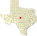
Salt Gap, Texas | |
---|---|
Coordinates: 31°18′14″N99°35′57″W / 31.30389°N 99.59917°W | |
Country | United States |
State | Texas |
County | McCulloch |
Elevation | 1,670 ft (510 m) |
Time zone | UTC-6 (Central (CST)) |
• Summer (DST) | UTC-5 (CDT) |
Area code | 325 |
GNIS feature ID | 1380482 [1] |
Salt Gap is an unincorporated community in McCulloch County, Texas, United States. Salt Gap is located at the junction of FMs 503 and 504 in western McCulloch County. The community had a post office from 1905 to 1913 and from 1924 to after 1930. Its population was 25 as of 2000. [2]
McCulloch County is a county located on the Edwards Plateau in the U.S. state of Texas. At the 2020 census, its population was 7,630. Its county seat is Brady. The county was created in 1856 and later organized in 1876. It is named for Benjamin McCulloch, a famous Texas Ranger and Confederate general.
Brady is a city in McCulloch County, Texas, United States. Brady refers to itself as the "Heart of Texas", as it is the city closest to the geographical center of the state, which is about 15 miles northeast of Brady. Its population was 5,118 at the 2020 census. It is the county seat of McCulloch County.
Brigadier-General Benjamin McCulloch was a soldier in the Texas Revolution, a Texas Ranger, a major-general in the Texas militia and thereafter a major in the United States Army during the Mexican–American War, sheriff of Sacramento County, a U.S. marshal, and a brigadier-general in the army of the Confederate States during the American Civil War. He owned at least 91 slaves.
Henry Eustace McCulloch was a soldier in the Texas Revolution, a Texas Ranger, and a brigadier general in the army of the Confederate States during the American Civil War.
North American area code 325 is a state of Texas area code for telephone numbers in the Abilene and San Angelo areas. It was created, along with area code 432, on April 5, 2003, in a split from area code 915.
The geography of Texas is diverse and large. Occupying about 7% of the total water and land area of the U.S., it is the second largest state after Alaska, and is the southernmost part of the Great Plains, which end in the south against the folded Sierra Madre Oriental of Mexico. Texas is in the South Central United States of America, and is considered to form part of the U.S. South and also part of the U.S. Southwest.
Rochelle is an unincorporated community in McCulloch County, Texas, United States. According to the Handbook of Texas, the community had an estimated population of 163 in 2000.
Lohn is an unincorporated community in McCulloch County, Texas, United States. According to the Handbook of Texas, the community had an estimated population of 149 in 2000.
The Lohn Independent School District is a public school district based in the community of Lohn, Texas, United States.
The San Elizario Salt War, also known as the Salinero Revolt or the El Paso Salt War, was an extended and complex range war of the mid-19th century that revolved around the ownership and control of immense salt lakes at the base of the Guadalupe Mountains in West Texas. What began in 1866 as a political and legal struggle among Anglo Texan politicians and capitalists gave rise in 1877 to an armed struggle by ethnic Mexican and Tejano inhabitants living on both sides of the Rio Grande near El Paso against a leading politician, who was supported by the Texas Rangers. The struggle reached its climax with the siege and surrender of 20 Texas Rangers to a popular army of perhaps 500 men in the town of San Elizario, Texas. The arrival of the African-American 9th Cavalry and a sheriff's posse of New Mexico mercenaries caused hundreds of Tejanos to flee to Mexico, some in permanent exile. The right of individuals to own the salt lakes, which had previously been held as a community asset, was established by force of arms.
Calf Creek is a small community located in southern McCulloch County, Texas on Farm to Market Road 1311 approximately 15 miles (24 km) southwest of Brady.
Doole is an unincorporated community in McCulloch County, Texas, United States. The community had an estimated population of 74 in 1990.
Mercury is an unincorporated community in McCulloch County, Texas, United States. According to the Handbook of Texas, the community had an estimated population of 166 in 2000.
Voca is an unincorporated community in McCulloch County, Texas, United States. According to the Handbook of Texas, the community had an estimated population of 56 in 2000.
Pear Valley is an unincorporated community in McCulloch County, Texas, United States. According to the Handbook of Texas, the community had an estimated population of 37 in 2000.
Fife is an unincorporated community in McCulloch County, Texas, United States. According to the Handbook of Texas, the community had an estimated population of 32 in 2000 and was established by Robert Kaye Finlay.
The Old McCulloch County Jail is located in Brady, McCulloch County, in the U.S. state of Texas. It was added to the National Register of Historic Places listings in McCulloch County, Texas in 1975, and became a Recorded Texas Historic Landmark in 1976. In 1963, the Texas Historical Commission designated the geographical center of Texas as being located 5 miles (8.0 km) northwest of Brady. The old jail became the Heart of Texas Historical Museum in 1974. A granite monument to the center of Texas can be found on the grounds of the McCulloch County Courthouse.
The McCulloch County Courthouse is located in Brady, McCulloch County, in the U.S. state of Texas. It was added to the National Register of Historic Places listings in McCulloch County, Texas in 1977, and became a Recorded Texas Historic Landmark in 1967.
This is a list of the National Register of Historic Places listings in McCulloch County, Texas.
The 1996 United States presidential election in Texas took place on November 5, 1996. All fifty states, and the District of Columbia, took part in the 1996 United States presidential election. State voters chose 32 electors to the Electoral College, which selected the president and vice president.