
Upton County is a county located on the Edwards Plateau in the U.S. state of Texas. As of the 2020 census, its population was 3,308. Its county seat is Rankin. The county was created in 1887 and later organized in 1910. It is named for two brothers: John C. and William F. Upton, both colonels in the Confederate Army.

Terry County is a county located in the U.S. state of Texas. As of the 2020 census, its population was 11,831. Its county seat is Brownfield. The county was demarked in 1876 and organized in 1904. It is named for Benjamin Franklin Terry, a colonel in the Confederate Army. Terry County was one of 46 dry counties in the state of Texas, but is now a moist county. Terry County is one of the most productive pumpkin producing counties in the United States.

Midland County is a county located in the U.S. state of Texas. As of 2020, the population was 169,983. The county seat is Midland. The county is so named for being halfway (midway) between Fort Worth and El Paso on the Texas and Pacific Railway. Midland County is included in the Midland, TX Metropolitan Statistical Area as well as the Midland–Odessa Combined Statistical Area.

Ector County is a county located in the U.S. state of Texas. In the 2020 census, its population was 165,171. Its county seat is Odessa. The county was founded in 1887 and organized in 1891. It is named for Matthew Ector, a Confederate general in the American Civil War.

Crane County is a county located in the U.S. state of Texas. As of the 2020 census, its population was 4,675. The county seat is Crane. The county was created in 1887 and later organized in 1927. It was named for William Carey Crane, a president of Southern Baptist-affiliated Baylor University in Waco, Texas.

Salem is a census-designated place (CDP) in Saline County, Arkansas, United States. Per the 2020 census, the population was 2,544. It is part of the Little Rock–North Little Rock–Conway Metropolitan Statistical Area.
Springfield is a city in Bay County, Florida, United States, east of Panama City. It is part of the Panama City–Panama City Beach, Florida Metropolitan Statistical Area. Springfield was incorporated on February 12, 1935. The population was 8,075 at the 2020 census, down from 8,903 at the 2010 census.
Alford is a town in Jackson County, Florida, United States. The Town of Alford is located on the Florida Panhandle near Marianna, in North Florida. The population was 484 at the 2020 census.
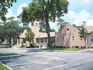
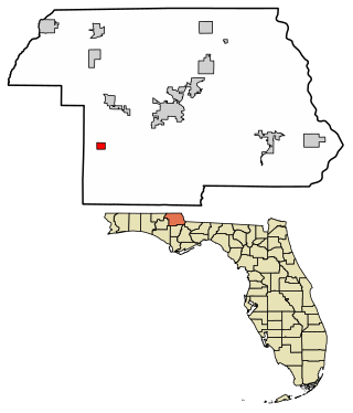
Belleview is a city in Marion County, Florida, United States. The population was 5,413 at the 2020 census, up from 4,492 in 2010. It is part of the Ocala Metropolitan Statistical Area. The city's name comes from the French words belle and vue, meaning "beautiful view". "City with Small Town Charm" is the city's motto.

Dunnellon is a city in Marion County, Florida, United States. The population was 1,928 at the 2020 census, up from 1,733 in 2010. It is part of the Ocala Metropolitan Statistical Area.

Gruver is a city in Emmet County, Iowa, United States. The population was 63 at the time of the 2020 census.

Parshall is a city lying within the jurisdictional boundaries of the Mandan, Hidatsa, and Arikara Nation. It is located on the Fort Berthold Indian Reservation in Mountrail County, North Dakota, United States. The population was 949 at the 2020 census. Parshall was founded in 1914 by George Parshall, and is the home of the Paul Broste Rock Museum.
Andrews is the county seat of Andrews County in the Permian Basin of West Texas. Andrews sits to the far southwest within the Texas Panhandle's plains, about 30 miles east of New Mexico.
Whiteface is a town in Cochran County, Texas, United States. The population was 449 at the 2010 census.
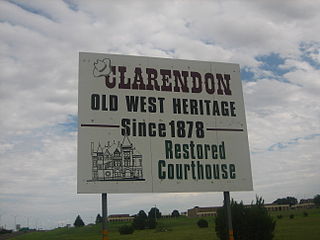
Clarendon is a city in Donley County, Texas, United States. Its population was 1,877 at the 2020 census. The county seat of Donley County, Clarendon is located on U.S. Highway 287 in the Texas Panhandle, 60 miles (97 km) east of Amarillo.
Ranger is a city in Eastland County, Texas, United States. Its population was 2,300 at the 2020 census. Ranger College, a community college, is the second-largest employer in the community.

Sour Lake is a city in Hardin County, Texas, United States. The population was 1,773 at the 2020 census. It was originally named "Sour Lake Springs", after the sulphurous spring water that flowed into the nearby lake. The city is part of the Beaumont–Port Arthur Metropolitan Statistical Area. Sour Lake is the oldest surviving town in Hardin County. It is called by some the "Gateway to the Big Thicket".

Iraan is a city in Pecos County, Texas, United States. Its population was 1,055 at the 2020 census. The city's name is an amalgamation of the first names of Ira and Ann Yates, owners of the ranch land upon which the town was built.

McCamey is a city in Upton County, Texas, United States. Its population was 1,831 at the 2020 census. The Texas legislature has declared McCamey "the Wind Energy Capital of Texas" because of the many wind farms that have been built in the area. Its history, however, is primarily that of an oil boomtown.

Newark is a city in Tarrant and Wise counties in the U.S. state of Texas. The population was 1,096 in 2020.


