McCamey, Texas

Last updated

McCamey, Texas
McCamey, TX, City Hall DSCN1379.JPG
McCamey City Hall at 207 E. 6th St.
TXMap-doton-McCamey.PNG
Location of McCamey, Texas
Upton County McCamey.svg
Coordinates: 31°7′56″N102°13′20″W / 31.13222°N 102.22222°W / 31.13222; -102.22222
Country United States
State Texas
County Upton
Area
[1]
  Total2.03 sq mi (5.25 km2)
  Land2.03 sq mi (5.25 km2)
  Water0.00 sq mi (0.00 km2)
Elevation
2,467 ft (752 m)
Population
 (2010)
  Total1,887
  Estimate 
(2019) [2]
2,060
  Density1,016.28/sq mi (392.43/km2)
Time zone UTC-6 (Central (CST))
  Summer (DST) UTC-5 (CDT)
ZIP code
79752
Area code 432
FIPS code 48-45432 [3]
GNIS feature ID1362369 [4]
Website Official website

McCamey is a city in Upton County, Texas, United States. Its population was 1,887 at the 2010 census. [5] The Texas legislature has declared McCamey "the Wind Energy Capital of Texas" because of the many wind farms that have been built in the area. Its history, however, is primarily that of an oil boomtown.

Contents

Geography

McCamey is located at 31°7′56″N102°13′20″W / 31.13222°N 102.22222°W / 31.13222; -102.22222 (31.132300, –102.222106). [6] The town is approximately five miles (8 km) east of the Pecos River along U.S. Route 67.

According to the United States Census Bureau, the city has a total area of 2.0 square miles (5.2 km2), all land.

Climate

According to the Köppen Climate Classification system, McCamey has a hot semi-arid climate, abbreviated "BSh" on climate maps. The hottest temperature recorded in McCamey was 113 °F (45.0 °C) on June 20, 1934, August 12, 1936 and June 27, 1994, while the coldest temperature recorded was −2 °F (−18.9 °C) on January 11, 1962. [7]

Climate data for McCamey, Texas, 1991–2020 normals, extremes 1932–present
MonthJanFebMarAprMayJunJulAugSepOctNovDecYear
Record high °F (°C)88
(31)
94
(34)
99
(37)
105
(41)
109
(43)
113
(45)
112
(44)
113
(45)
108
(42)
103
(39)
93
(34)
91
(33)
113
(45)
Mean maximum °F (°C)79.9
(26.6)
84.3
(29.1)
90.9
(32.7)
96.2
(35.7)
102.3
(39.1)
105.3
(40.7)
104.2
(40.1)
102.6
(39.2)
99.5
(37.5)
94.8
(34.9)
84.9
(29.4)
79.4
(26.3)
107.2
(41.8)
Average high °F (°C)60.5
(15.8)
65.8
(18.8)
74.2
(23.4)
82.3
(27.9)
89.8
(32.1)
95.5
(35.3)
96.3
(35.7)
95.9
(35.5)
89.5
(31.9)
80.8
(27.1)
69.6
(20.9)
61.4
(16.3)
80.1
(26.7)
Daily mean °F (°C)46.7
(8.2)
51.5
(10.8)
59.4
(15.2)
67.6
(19.8)
76.3
(24.6)
83.2
(28.4)
84.8
(29.3)
84.3
(29.1)
77.6
(25.3)
68.1
(20.1)
56.0
(13.3)
47.8
(8.8)
66.9
(19.4)
Average low °F (°C)32.8
(0.4)
37.2
(2.9)
44.6
(7.0)
53.0
(11.7)
62.8
(17.1)
70.9
(21.6)
73.3
(22.9)
72.7
(22.6)
65.7
(18.7)
55.3
(12.9)
42.5
(5.8)
34.1
(1.2)
53.7
(12.1)
Mean minimum °F (°C)20.7
(−6.3)
24.1
(−4.4)
29.2
(−1.6)
36.6
(2.6)
47.5
(8.6)
61.9
(16.6)
66.8
(19.3)
65.4
(18.6)
53.1
(11.7)
37.6
(3.1)
26.5
(−3.1)
21.0
(−6.1)
16.8
(−8.4)
Record low °F (°C)−2
(−19)
−1
(−18)
12
(−11)
26
(−3)
33
(1)
44
(7)
60
(16)
55
(13)
38
(3)
22
(−6)
12
(−11)
6
(−14)
−2
(−19)
Average precipitation inches (mm)0.69
(18)
0.55
(14)
0.86
(22)
1.08
(27)
1.26
(32)
2.11
(54)
1.69
(43)
1.88
(48)
1.81
(46)
1.42
(36)
0.82
(21)
0.65
(17)
14.82
(378)
Average snowfall inches (cm)0.2
(0.51)
0.0
(0.0)
0.0
(0.0)
0.0
(0.0)
0.0
(0.0)
0.0
(0.0)
0.0
(0.0)
0.0
(0.0)
0.0
(0.0)
0.0
(0.0)
0.3
(0.76)
0.6
(1.5)
1.1
(2.77)
Average precipitation days (≥ 0.01 in)3.22.62.92.34.03.23.74.24.03.32.12.538.0
Average snowy days (≥ 0.1 in)0.20.00.00.00.00.00.00.00.00.00.10.10.4
Source 1: NOAA [8]
Source 2: National Weather Service [7]

History

Downtown McCamey McCamey, TX DSCN1382.JPG
Downtown McCamey

McCamey is named for George B. McCamey, whose 1925 wildcat well brought about the oil boom in the region. He brought in a real estate developer from Corpus Christi, to lay out a townsite near the oil field and along the Kansas City, Mexico and Orient Railway capable of housing 10,000 people. The town was initially a jumble of tents and frame shacks; order came slowly, replacing the lawlessness of the early boomtown environment. A post office was built in 1926, and the town was incorporated near the end of that year. In 1927, the McCamey Independent School District was formed, and an enterprising newspaperman printed the first issue of the Tri-County Record, the first town newspaper. [9]

Water supply was a problem in the early years of McCamey, as the nearby water sources were not drinkable. Water came in by train from Alpine, almost 100 miles (160 km) away, at a cost of $1 a barrel. A potable water supply was found in a geologic unit only 17 miles (27 km) distant, and pipes were built to transport it to town in 1929. [10]

McCamey was the location of a Humble Oil Company Refinery, one of the first built in West Texas. Humble Oil & Refining Company was a corporate predecessor of Exxon Company. An early experiment by Shell Oil Company in massive oil storage in McCamey proved a failure; local oilmen built a reservoir to hold up to one million barrels of oil in an earthen tank, but the limestone formation underneath the tank cracked under the weight of the crude, allowing much of it to leak into the subsurface. [9]

The population of the town declined during the Great Depression along with the price of oil, and as the discovery of large oil fields elsewhere pulled workers away. In 1940, 2,600 people were in McCamey; in 1980, 2,436; and the 2000 census showed the population had shrunk to 1,805. [9]

Demographics

Historical population
CensusPop.Note
1930 3,446
1940 2,595−24.7%
1950 3,12120.3%
1960 3,3758.1%
1970 2,647−21.6%
1980 2,436−8.0%
1990 2,4932.3%
2000 1,805−27.6%
2010 1,8874.5%
2019 (est.)2,060 [2] 9.2%
U.S. Decennial Census [11]

2020 census

McCamey racial composition [12]
(NH = Non-Hispanic) [lower-alpha 1]
RaceNumberPercentage
White (NH)49827.2%
Black or African American (NH)432.35%
Native American or Alaska Native (NH)10.05%
Asian (NH)20.11%
Some Other Race (NH)10.05%
Mixed/Multi-Racial (NH)442.4%
Hispanic or Latino 1,24267.83%
Total1,831

As of the 2020 United States census, there were 1,831 people, 693 households, and 425 families residing in the city.

2000 census

As of the census [3] of 2000, 1,805 people, 676 households, and 494 families resided in the city. The population density was 900.4 inhabitants per square mile (347.6/km2). The 854 housing units averaged 426.0/sq mi (164.9/km2). The racial makeup of the city was 72.30% White, 1.55% African American, 1.27% Native American, 23.82% from other races, and 1.05% from two or more races. Hispanics or Latinos of any race were 52.30% of the population.

Of the 676 households, 35.7% had children under the age of 18 living with them, 58.1% were married couples living together, 10.9% had a female householder with no husband present, and 26.9% were not families. About 24.9% of all households were made up of individuals, and 12.4% had someone living alone who was 65 years of age or older. The average household size was 2.67 and the average family size was 3.20.

In the city, the age distribution was 30.3% under the age of 18, 8.0% from 18 to 24, 24.7% from 25 to 44, 22.6% from 45 to 64, and 14.4% who were 65 years of age or older. The median age was 36 years. For every 100 females, there were 95.1 males. For every 100 females age 18 and over, there were 91.2 males.

The median income for a household in the city was $25,233, and for a family was $28,906. Males had a median income of $31,513 versus $16,724 for females. The per capita income for the city was $12,171. About 23.2% of families and 24.7% of the population were below the poverty line, including 30.6% of those under age 18 and 16.6% of those age 65 or over.

Education

The City of McCamey is served by the McCamey Independent School District.

Notable people

Climate

According to the Köppen climate classification, McCamey has a semiarid climate, BSk on climate maps. [16]

Related Research Articles

<span class="mw-page-title-main">Upton County, Texas</span> County in Texas, United States

Upton County is a county located on the Edwards Plateau in the U.S. state of Texas. As of the 2020 census, its population was 3,308. Its county seat is Rankin. The county was created in 1887 and later organized in 1910. It is named for two brothers: John C. and William F. Upton, both colonels in the Confederate Army.

<span class="mw-page-title-main">Seymour, Texas</span> City in Texas, United States

Seymour is a city in and the county seat of Baylor County, Texas, United States. Its population was 2,575 as of the 2020 Census.

<span class="mw-page-title-main">Hart, Texas</span> City in Texas, United States

Hart is a city in Castro County, Texas, United States. The population was 1,114 at the 2010 census.

<span class="mw-page-title-main">Whiteface, Texas</span> Community in Texas, United States

Whiteface is a town in Cochran County, Texas, United States. The population was 449 at the 2010 census.

<span class="mw-page-title-main">Crane, Texas</span> City in Texas, United States

Crane is a city in and the county seat of Crane County, Texas, United States. Its population is about 3,680 as of 2018. An oil boomtown since the 1920s, Crane is still in the center of a prominent oil-producing region. It is the only significant town in sparsely populated Crane County, and contains the only post office in the county.

<span class="mw-page-title-main">Ranger, Texas</span> City in Texas, United States

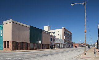
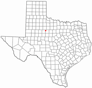
Ranger is a city in Eastland County, Texas, United States. Its population was 2,468 at the 2010 census. Ranger College, a community college, is the second-largest employer in the community.

<span class="mw-page-title-main">Pearsall, Texas</span> City in Texas, United States

Pearsall is a city in and the county seat of Frio County, Texas, United States. The population was 9,146 at the 2010 census, up from 7,157 at the 2000 census.

<span class="mw-page-title-main">Grapeland, Texas</span> City in Texas, United States

Grapeland is a city in Houston County, Texas, United States. Its population was 1,465 as of the 2020 census.

<span class="mw-page-title-main">Olton, Texas</span> City in Texas, United States

Olton is a city in Lamb County, Texas, United States. The population was 2,215 at the 2010 census.

<span class="mw-page-title-main">Sunray, Texas</span> City in Texas, United States

Sunray is a city in northeastern Moore County, Texas, United States. The population was 1,926 at the 2010 census.

<span class="mw-page-title-main">Vega, Texas</span> City in Texas, United States

Vega is a city and county seat of Oldham County, Texas, United States. The population was 884 at the 2010 census, down from 936 at the 2000 census.

<span class="mw-page-title-main">Friona, Texas</span> City in Texas, United States

Friona is a city in Parmer County, Texas, United States. The population was 4,123 at the 2010 census. Friona was established as a small community in 1898 by XIT Ranch, originally called Frio, which is also the word for "cold" in Spanish.

<span class="mw-page-title-main">Iraan, Texas</span> City in Texas, United States

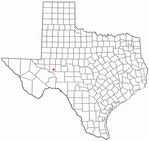
Iraan is a city in Pecos County, Texas, United States. Its population was 1,055 at the 2020 census. The city's name is an amalgamation of the first names of Ira and Ann Yates, owners of the ranch land upon which the town was built.

<span class="mw-page-title-main">Refugio, Texas</span> Town in Texas, United States

Refugio is a town in Refugio County, of which it is the county seat, in the U.S. state of Texas. The population was 2,890 as of the 2010 Census. Refugio is the birthplace of Baseball Hall of Fame member Nolan Ryan.

<span class="mw-page-title-main">Taft, Texas</span> City in Texas, United States

Taft is a city in San Patricio County, Texas, United States. The population was 3,048 at the 2010 census.

<span class="mw-page-title-main">Rankin, Texas</span> City in Texas, United States

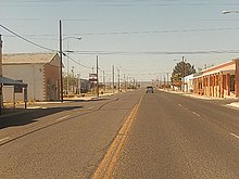
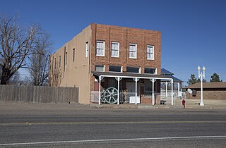
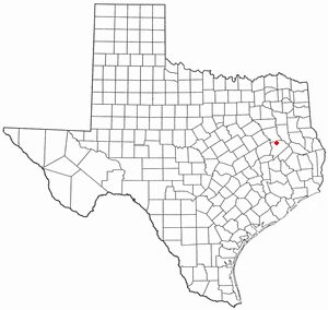
Rankin is a city in Upton County, Texas, United States. Its population was 778 at the 2010 census. It is named after F.E. Rankin, a local rancher. It is the county seat of the thinly populated county; in 2010, only 3,355 people lived in the entire county, and McCamey was the only larger town. During the early 20th century, the town grew due to the discovery of oil in the nearby Yates Oil Field. However, following a second oil boom in the '80s the town saw a decline in its economy and population.

<span class="mw-page-title-main">Grandfalls, Texas</span> Town in Texas, United States

Grandfalls is a town in Ward County, Texas, United States. It was named for its location near the "grand falls" of the Pecos River, located roughly 3 miles (4.8 km) to the west. Early settlers were attracted to the Grandfalls area in the late 1880s by the steady supply of water flowing in the Pecos River. Its population was 360 at the 2010 census.

<span class="mw-page-title-main">Wheeler, Texas</span> City in Texas, United States

Wheeler is a city, and the county seat of Wheeler County, Texas, United States, located on the eastern border of the Texas Panhandle. The population was last reported at 1,592 in the 2010 census.

<span class="mw-page-title-main">Plains, Texas</span> Town in Texas, United States

Plains is a town and the county seat of Yoakum County of western Texas, United States, particularly the south (inner) half of the panhandle's plains. The city's population was 1,481 at the 2010 census. Plains is in the Texas High Plains Wine country.

<span class="mw-page-title-main">Hamlin, Texas</span> City in Texas, United States

Hamlin is a city in Jones and Fisher Counties in the U.S. state of Texas. The population was 2,124 at the 2010 census, and in 2018, the estimated population was 1,997. The Jones County portion of Hamlin is part of the Abilene, Texas metropolitan area.

References

  1. "2019 U.S. Gazetteer Files". United States Census Bureau. Retrieved August 7, 2020.
  2. 1 2 "Population and Housing Unit Estimates". United States Census Bureau. May 24, 2020. Retrieved May 27, 2020.
  3. 1 2 "U.S. Census website". United States Census Bureau . Retrieved January 31, 2008.
  4. "US Board on Geographic Names". United States Geological Survey. October 25, 2007. Retrieved January 31, 2008.
  5. "Population and Housing Unit Counts, 2010 Census of Population and Housing" (PDF). Texas: 2010. Retrieved January 2, 2017.
  6. "US Gazetteer files: 2010, 2000, and 1990". United States Census Bureau. February 12, 2011. Retrieved April 23, 2011.
  7. 1 2 "NOAA Online Weather Data – NWS Midland". National Weather Service. Retrieved November 29, 2023.
  8. "U.S. Climate Normals Quick Access – Station: McCamey, TX". National Oceanic and Atmospheric Administration. Retrieved November 29, 2023.
  9. 1 2 3 McCamey, Texas, in the Handbook of Texas Online
  10. Upton County history from Handbook of Texas Online
  11. "Census of Population and Housing". Census.gov. Retrieved June 4, 2015.
  12. "Explore Census Data". data.census.gov. Retrieved May 19, 2022.
  13. https://www.census.gov/ [ not specific enough to verify ]
  14. "About the Hispanic Population and its Origin". www.census.gov. Retrieved May 18, 2022.
  15. "William R. "Bill" Keffer". votesmart.org. Retrieved September 26, 2013.
  16. Climate Summary for McCamey, Texas
  1. Note: the US Census treats Hispanic/Latino as an ethnic category. This table excludes Latinos from the racial categories and assigns them to a separate category. Hispanics/Latinos can be of any race. [13] [14]