Lodi, Texas

Last updated

Lodi
LodiTexasPostOffice1.jpg
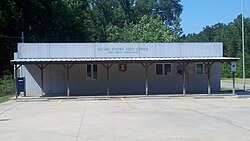
Lodi Post Office, May 2011
USA Texas location map.svg
Red pog.svg
Lodi
Location within the state of Texas
Usa edcp location map.svg
Red pog.svg
Lodi
Lodi (the United States)
Coordinates: 32°52′28″N94°16′48″W / 32.87444°N 94.28000°W / 32.87444; -94.28000
Country United States
State Texas
County Marion
Elevation
[1]
253 ft (77 m)
Time zone UTC-6 (Central (CST))
  Summer (DST) UTC-5 (CDT)
ZIP codes
75564
Area code(s) 903, 430
GNIS feature ID1378592 [1]

Lodi is an unincorporated community in northern Marion County, Texas, United States. [2] Its elevation is 253 feet (77 m). [3] It has a post office with the ZIP code 75564. The only business in Lodi, Texas is Lodi Drilling & Service Company Inc. [4]

Contents

The settlement is named for Lodi, Italy.

Methodist church in Lodei, May 2011 LodiChurch1.jpg
Methodist church in Lodei, May 2011

See also

Flag of Texas.svg Texasportal

Related Research Articles

Wellington is an unincorporated town in southwestern Lyon County, Nevada, United States. It lies along State Route 208, southwest of the city of Yerington, the county seat of Lyon County. Wellington has a post office with the ZIP code 89444,

Rio Frio is an unincorporated community in southeastern Real County, Texas, United States. It lies just off U.S. Route 83, south of the city of Leakey, the county seat of Real County. Its elevation is 1,483 feet (452 m). It has a post office, with the ZIP code 78879. The town is named after the Frio River, on which it is situated.

<span class="mw-page-title-main">Griffithsville, West Virginia</span> Unincorporated community in West Virginia, United States

Griffithsville is an unincorporated community in eastern Lincoln County, West Virginia, United States. It has a population of 1,101. It lies along West Virginia Route 3 southeast of the town of Hamlin, the county seat of Lincoln County. Its elevation is 659 feet (201 m). It has a post office with the ZIP code 25521.

Galloway is a census-designated place (CDP) and coal town in northwestern Barbour County, West Virginia, United States. It lies along West Virginia Route 76 northwest of the city of Philippi, the county seat of Barbour County. Its elevation is 1,073 feet (327 m). It has a post office with the ZIP code 26349. As of the 2010 census, its population is 143.

West Grove is an unincorporated community in western Davis County, Iowa, United States. It lies along Iowa Highway 2 west of the city of Bloomfield, the county seat of Davis County. Its elevation is 942 feet (287 m).

Donie is an unincorporated community in southern Freestone County, Texas, United States. It lies along State Highway 164 south of the city of Fairfield, the county seat of Freestone County. Its elevation is 489 feet (149 m). Although Donie is unincorporated, it has a post office, with the ZIP code of 75838.

Flint is an unincorporated community in southeastern Smith County, Texas, United States. It lies along FM 2493, south of the city of Tyler, the county seat of Smith County. Its elevation is 522 feet (159 m). Although Flint is unincorporated, it has a post office, with the ZIP code of 75762.

Doucette is an unincorporated community in central Tyler County, Texas, United States. It lies along U.S. Route 69, north of the town of Woodville, the county seat of Tyler County. Although Doucette is unincorporated, it has a post office, with the ZIP code of 75942.

Hillister is an unincorporated community in southern Tyler County, Texas, United States. It lies along the concurrent U.S. Routes 69 and 287, south of the town of Woodville, the county seat of Tyler County. Although Hillister is unincorporated, it has a post office, with the ZIP code of 77624.

Cookville is an unincorporated community in eastern Titus County, Texas, United States. It lies along U.S. Route 67, east of the city of Mount Pleasant, the county seat of Titus County. Although Cookville is unincorporated, it has a post office, with the ZIP code of 75558, located at the junction of US 67 and Farm to Market Road 1000.

<span class="mw-page-title-main">Lincoln, Texas</span> Unincorporated community in Texas, United States

Lincoln is an unincorporated community in central Lee County, Texas, United States. It lies along Highway 21, north of the city of Giddings, the county seat of Lee County. Although Lincoln is unincorporated, it has a post office, with the ZIP code of 78948.

Knott is an unincorporated community in northwestern Howard County, Texas, United States. It lies along FM 846 northwest of the city of Big Spring, the county seat of Howard County. Its elevation is 2,612 feet (796 m). Although Knott is unincorporated, it has a post office, with the ZIP code of 79748.

Prairie Hill is an unincorporated community in western Limestone County, Texas, United States. It lies along U.S. Route 84, northwest of the city of Groesbeck, the county seat of Limestone County. Its elevation is 594 feet (181 m). Although Prairie Hill is unincorporated, it has a post office, with the ZIP code of 76678.

<span class="mw-page-title-main">Knickerbocker, Texas</span> Unincorporated community in Tom Green County, Texas, United States

Knickerbocker is an unincorporated community in southwestern Tom Green County, Texas, United States. It lies along Farm to Market Road 2335, southwest of the city of San Angelo, the county seat of Tom Green County. Its elevation is 2,051 feet (625 m). Although Knickerbocker is unincorporated, it has a post office, with the ZIP code of 76939.

Aiken is an unincorporated community in western Floyd County, Texas, United States. It lies along U.S. Route 70 north of the city of Floydada, the county seat of Floyd County. Its elevation is 3,300 feet (1,006 m). Although Aiken is unincorporated, it has a post office, with the ZIP code of 79221.

Vancourt is an unincorporated community in eastern Tom Green County, Texas, United States. It lies along U.S. Route 87 east of the city of San Angelo, the county seat of Tom Green County. Its elevation is 1,867 feet (569 m). Although Vancourt is unincorporated, it has a post office, with the ZIP code of 76955; the ZCTA for ZIP Code 76955 had a population of 108 at the 2000 census.

Mereta is an unincorporated community in eastern Tom Green County, Texas, United States. It lies along local roads east of the city of San Angelo, the county seat of Tom Green County. Its elevation is 1,755 feet (535 m). Although Mereta is unincorporated, it has a post office, with the ZIP code of 76940; the ZCTA for ZIP Code 76940 had a population of 138 at the 2000 census.

<span class="mw-page-title-main">Waring, Texas</span> Unincorporated community in Texas, United States

Waring is an unincorporated community in northwestern Kendall County, Texas, United States. It lies along local roads and the Guadalupe River, northwest of the city of Boerne, the county seat of Kendall County. Its elevation is 1,345 feet (410 m). Although Waring is unincorporated, it has a post office, with the ZIP code of 78074; the ZCTA for ZIP Code 78074 had a population of 59 at the 2000 census. The community is part of the San Antonio Metropolitan Statistical Area.

<span class="mw-page-title-main">Kendalia, Texas</span> Unincorporated community in Kendall County, Texas

Kendalia is an unincorporated community in northeastern Kendall County, Texas, United States. It is part of the Texas-German belt.

<span class="mw-page-title-main">Thomaston, Texas</span> Unincorporated community in Texas, United States

Thomaston is an unincorporated community in southeastern DeWitt County, Texas, United States. It lies along U.S. Route 87, southeast of the city of Cuero, the county seat of DeWitt County. Its elevation is 161 feet (49 m). Although Thomaston is unincorporated, it has a post office, with the ZIP code of 77989.

References

  1. 1 2 U.S. Geological Survey Geographic Names Information System: Lodi, Texas
  2. Rand McNally. The Road Atlas '06. Chicago: Rand McNally, 2006, p. 101.
  3. U.S. Geological Survey Geographic Names Information System: Lodi, Texas, Geographic Names Information System, 1979-11-30. Accessed 2007-12-23.
  4. USPS – Cities by ZIP Code