
Stonewall County is a county located in the U.S. state of Texas. As of the 2020 census, its population was 1,245. Its county seat is Aspermont. The county was created in 1876 and organized in 1888. It is named for Stonewall Jackson, a general of the Confederate States Army.

Haskell County is a county located in the U.S. state of Texas. As of the 2020 census, its population was 5,416. The county seat is Haskell. The county was created in 1858 and later organized in 1885. It is named for Charles Ready Haskell, who was killed in the Goliad massacre.

The Brazos River, called the Río de los Brazos de Dios by early Spanish explorers, is the 14th-longest river in the United States at 1,280 miles (2,060 km) from its headwater source at the head of Blackwater Draw, Roosevelt County, New Mexico to its mouth at the Gulf of Mexico with a 45,000-square-mile (116,000 km2) drainage basin. Being one of the largest rivers in Texas, it is sometimes used to mark the boundary between East Texas and West Texas.
Fluvanna is an unincorporated community and census designated place (CDP) in Scurry County, Texas, United States. It lies just south of the Llano Estacado, high atop the caprock, where Farm to Market Road 1269 and Farm to Market Road 612 intersect.
The Salt Fork Red River is a sandy-braided stream about 311 km (193 mi) long, heading on the Llano Estacado of West Texas about 2.9 km (1.8 mi) north of Claude of Armstrong County, Texas, flowing east across the Texas Panhandle and Western Oklahoma to join the Red River about 21 km (13 mi) south of Altus of Jackson County, Oklahoma.

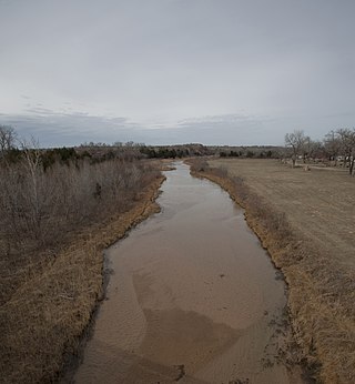
The Pease River is a river in Texas, United States. It is a tributary of the Red River that runs in an easterly direction through West Texas. It was discovered and mapped for the first time in 1856 by Jacob de Córdova, who found the river while surveying for the Galveston, Houston and Henderson Railroad Company; it was named after Texas Governor Elisha M. Pease. In December 1860, the Texas Rangers recaptured Cynthia Ann Parker, kidnapped by the Comanche Indians in 1836, and her daughter from the Comanche at an engagement along the river.

Clairemont is a ghost town in and the former county seat of Kent County, Texas, United States. It is at the intersection of U.S. Route 380 and Texas State Highway 208, 14 mi (23 km) southwest of Jayton and 43 mi (69 km) east of Post. Clairemont lies near the center of Kent County, and the estimated population as of the 2000 census was 15.

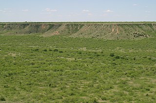
Double Mountains is the name of a pair of flat-topped buttes located 13 miles (21 km) southwest of Aspermont in Stonewall County, Texas. While the Handbook of Texas gives their elevation as either 2,000 ft (610 m) or 2,400 ft (732 m), United States Geological Survey maps give the elevation of the western mountain as 2,523 ft (769 m) and that of the eastern mountain as between 2,580 and 2,600 ft. Together, the mountains form part of the high ground dividing the watersheds of the Salt Fork and Double Mountain Fork Brazos River.
Jud is a ghost town in extreme western Haskell County, Texas, United States. It lies on FM 617, 7 miles (11 km) west of Rochester. The Double Mountain Fork and Salt Fork Brazos River merge approximately 3 miles (4.8 km) west of present-day Jud to form the Brazos River.

The Clear Fork Brazos River is the longest tributary of the Brazos River of Texas. It originates as a dry channel or draw in Scurry County about 2 mi (3.2 km) northeast of Hermleigh and runs for about 180 mi (290 km) through portions of Scurry, Fisher, Jones, Shackelford, and Throckmorton counties before joining the main stem of the Brazos River in Young County about 7.8 mi (12.6 km) south-southeast of Graham, Texas.
The White River is an intermittent stream in the South Plains of Texas and a tributary of the Brazos River of the United States. It rises 8 miles (13 km) west of Floydada in southwestern Floyd County at the confluence of Callahan and Runningwater Draws. From there, it runs southeast for 62 miles (100 km) to its mouth on the Salt Fork of the Brazos River in northwestern Kent County. Besides these two headwaters, which rise near Hale Center and in Curry County, New Mexico, respectively, other tributaries include Pete, Crawfish, and Davidson Creeks. The White River drains an area of 1,690 sq mi (4,377 km2).
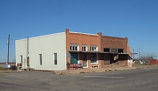
Old Glory is an unincorporated community in Stonewall County, Texas, United States. The community has an estimated population of 100.

Rhineland is an unincorporated community in Knox County, Texas, United States. According to the Handbook of Texas, the community had an estimated population of 100 in 2000.

Grassland is an unincorporated community in Lynn County, West Texas, United States. According to the Handbook of Texas, the community had an estimated population of 61 in 2000.

Peacock is an unincorporated community in Stonewall County, Texas, United States. According to the Handbook of Texas, the community had an estimated population of 125 in 2000.

The Double Mountain Fork Brazos River is an ephemeral, sandy-braided stream about 170 mi (280 km) long, heading on the Llano Estacado of West Texas about 11.5 mi (18.5 km) southeast of Tahoka, Texas, flowing east-northeast across the western Rolling Plains to join the Salt Fork, forming the Brazos River about 18 mi (29 km) west-northwest of Haskell, Texas.

The North Fork Double Mountain Fork Brazos River is an intermittent stream about 75 mi (121 km) long, heading at the junction of Blackwater Draw and Yellow House Draw in the city of Lubbock, flowing generally southeastward to its mouth on the Double Mountain Fork Brazos River in western Kent County. It crosses portions of Lubbock, Crosby, Garza, and Kent counties in West Texas.
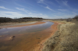
The Salt Fork Brazos River is a braided, highly intermittent stream about 150 mi (240 km) long, heading along the edge of the Llano Estacado about 26 mi (42 km) east-southeast of Lubbock, Texas. From its source, it flows generally east-southeastward to join the Double Mountain Fork to form the Brazos River about 18 mi (29 km) west-northwest of Haskell, Texas. The Salt Fork stretches across portions of Crosby, Garza, Kent, and Stonewall counties of West Texas.

Canyon Valley is a ghost town in southern Crosby County, Texas, United States. Today, only a few farms and ranches are scattered across the area.

Hobbs is an unincorporated community in west Fisher County, Texas, United States. It is located at the intersection of Farm to Market Roads 611 and 1614, about 20 mi (32 km) east of Snyder. It lies within the physiographic region known as the Rolling Plains in the valley of the Clear Fork Brazos River.


