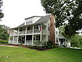
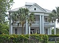
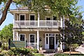
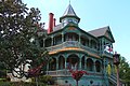
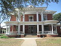
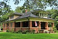
List of Recorded Texas Historic Landmarks (Trinity-Zavala)

Last updated

The following is a partial list of Recorded Texas Historic Landmarks (RTHLs) arranged by county as designated by the Texas Historical Commission and local county historical commissions in Texas. This page includes RTHLs in the following counties: Trinity, Tyler, Upshur, Upton, Uvalde, Val Verde, Van Zandt, Victoria, Walker, Waller, Ward, Washington, Webb, Wharton, Wheeler, Wichita, Wilbarger, Willacy, Williamson, Wilson, Winkler, Wise, Wood, Yoakum, Young, Zapata, and Zavala.

Contents

Recorded Texas Historic Landmarks listed by county
Anderson-CallahanCameron-DuvalEastland-GrayGrayson-HudspethHunt-MartinMason-RuskSabine-Travis • Trinity-Zavala

KEY

Landmarks with multiple historic designations are colored according to their highest designation within the following hierarchy.

⁕ Listed individually on the National Register of Historic Places (NRHP) as a National Historic Landmark
⁂ Listed on the NRHP as a contributing property of a National Historic Landmark District
Listed individually on the NRHP
Listed as a contributing property of an NRHP Historic District
§ Listed individually as or as part of a State Historic Site
# Listed individually as or as part of a State Antiquities Landmark

Trinity County

Registered Texas Historic LandmarkImageMarker numberPhysical addressNearest cityYear designatedDescription
I. N. Parker House 7963 304 N. Maple St.

30°56′50″N95°22′41″W / 30.94722°N 95.37806°W / 30.94722; -95.37806

Trinity 1996304 North Maple
John Henley Hill House 18373 2005 Pinecrest Rd.

30°55′4″N95°21′44″W / 30.91778°N 95.36222°W / 30.91778; -95.36222

Trinity 2016From the town of Trinity, go south on State Highway 19 to East Tatum Street, Turn left (east) go 2/10 mile to Pinecrest Road, turn right (south) and go 9/10 mile to driveway entrance on left.
Old Red Schoolhouse Old Red Schoolhouse full shot.jpg
Commons-logo.svg More images
15316 100 W. San Jacinto St.

30°56′34″N95°22′31″W / 30.94278°N 95.37528°W / 30.94278; -95.37528

Trinity 2004
Ranald McDonald House 7962 401 S. Maple St.

30°56′29″N95°22′38″W / 30.94139°N 95.37722°W / 30.94139; -95.37722

Trinity 1976Maple and San Jacinto
Trinity County Courthouse# Trinity county tx courthouse 2015.jpg 13075 162 W. First St.

31°3′21″N95°7′33″W / 31.05583°N 95.12583°W / 31.05583; -95.12583

Groveton 2004162 W First St

Tyler County

Registered Texas Historic LandmarkImageMarker numberPhysical addressNearest cityYear designatedDescription
Burch-Cauble House 11359 1936 FM 2097

30°56′54″N94°36′31″W / 30.94833°N 94.60861°W / 30.94833; -94.60861

Chester 1964N of Chester via US 287 E to FM 2097 N 5 mi to Peach Tree Village
Colmesneil, W.T., House 15459 106 S. Pitzer St.

30°54′23″N94°25′8″W / 30.90639°N 94.41889°W / 30.90639; -94.41889

Colmesneil 2008106 S. Pitzer
Cooper-Reid Home Cooper-Reid Home Woodville Wiki (1 of 1).jpg 11362 702 W. Bluff St.

30°46′33″N94°25′22″W / 30.77583°N 94.42278°W / 30.77583; -94.42278

Woodville 1968
David Curlee Enloe House 11365 FM 1745 E of CR 2836

30°56′5″N94°28′59″W / 30.93472°N 94.48306°W / 30.93472; -94.48306

Colmesneil 1967FM 1745 4.5 mi W of Colmesneil (east of CR 2836)
Early Law Office 11364 201 S. Beaver St.

30°46′27″N94°24′49″W / 30.77417°N 94.41361°W / 30.77417; -94.41361

Woodville 1968Structure has been torn down
James Barclay Place, 1842 11356 10 mi. SW of Woodville Woodville 1962
Pine Grove Missionary Baptist Church and School 16586 235 CR 2778

30°50′50″N94°28′12″W / 30.84722°N 94.47000°W / 30.84722; -94.47000

Dies 20100.14 mile N on CR 2778 from the intersection of CR 2778 and FM 1632
Tolar Kitchen 11456 157 Private Rd. 6000 at US 190 W

30°46′17″N94°26′39″W / 30.77139°N 94.44417°W / 30.77139; -94.44417

Woodville 1964Located 1.5 mi. W of Woodville at Heritage Museum
Tyler County Courthouse Tyler county tx courthouse 2014.jpg 12432 104 W. Bluff St.

30°46′30″N94°24′56″W / 30.77500°N 94.41556°W / 30.77500; -94.41556

Woodville 2000

Upshur County

Registered Texas Historic LandmarkImageMarker numberPhysical addressNearest cityYear designatedDescription
1925 Gilmer Post Office Gilmer September 2018 09 (Historic Upshur Museum - 1925 Gilmer Post Office).jpg 12254 119 Simpson St.

32°43′46″N94°56′37″W / 32.72944°N 94.94361°W / 32.72944; -94.94361

Gilmer 1998
Ben Phillips Place 11336 West Mountain Cemetery, 8100 US 271

32°36′55″N94°55′2″W / 32.61528°N 94.91722°W / 32.61528; -94.91722

Union Grove 1964?
Enon Baptist Church 11309 3063 FM 556

32°46′26″N95°2′19″W / 32.77389°N 95.03861°W / 32.77389; -95.03861

Gilmer 1966From Gilmer, take FM 852 5.2 mi NW to intersection w/FM 556, church is at intersection
John O'Byrne Home John and Eva O'Bryne House right side.JPG
Commons-logo.svg More images
11333 6488 FM 1844

32°35′3″N94°54′36″W / 32.58417°N 94.91000°W / 32.58417; -94.91000

Union Grove 1964
Lewis T. Mackey 11327 Union Grove Cemetery, 212 Union Grove Cemetery Rd.

32°33′59″N94°54′12″W / 32.56639°N 94.90333°W / 32.56639; -94.90333

Union Grove 1964
McDonald House 11328 1 mi. E on SH 154 Gilmer 1964
Old Alexander Cook Home 11304 12 mi. NW in Souls Chapel community Gilmer 196612 mi. NW of Gilmer
Old Hart Home 11317 1 mi. from Gilmer Gilmer 1966
Pritchett Normal Institute 11338 SH 155 at FM 1404

32°39′47″N95°0′58″W / 32.66306°N 95.01611°W / 32.66306; -95.01611

Gilmer 1967On SH 155, at intersection W/FM 1404, about 6 mi. SW of Gilmer
The Ashley Phelps Home 11335 107 N. Tyler St.

32°35′5″N95°6′32″W / 32.58472°N 95.10889°W / 32.58472; -95.10889

Big Sandy 1982
Warren-Futrell House Gilmer September 2018 21 (Warren-Futrell House).jpg 12574 303 Warren St.

32°43′25″N94°56′47″W / 32.72361°N 94.94639°W / 32.72361; -94.94639

Gilmer 2001

Upton County

Registered Texas Historic LandmarkImageMarker numberPhysical addressNearest cityYear designatedDescription
Adrian Building 90 S of E. 3rd. St. at Santa Fe St. in Santa Fe Park

31°8′15″N102°13′5″W / 31.13750°N 102.21806°W / 31.13750; -102.21806

McCamey 1965On US 67, Eastern edge of McCamey in Santa Fe Park
Bobcat Hills 444 FM 305 S. of Medical Dr.

31°6′45″N102°12′40″W / 31.11250°N 102.21111°W / 31.11250; -102.21111

McCamey 1967On FM 305, 7/10 mile S. of intersection w/ FM 1901 in McCamey.
Castle Mountain 755 US 385 7 mi. NW of McCamey

31°18′10″N102°17′29″W / 31.30278°N 102.29139°W / 31.30278; -102.29139

McCamey 1966US 385, 7 mi. NW of McCamey
Elliott Ranch 1460 100 W. 5th Ave.

31°13′15″N101°56′22″W / 31.22083°N 101.93944°W / 31.22083; -101.93944

Rankin 1965At the Yates Hotel (5th and Main Sts.) Rankin
Mendoza Trail McCamey, TX, Museum DSCN1101.JPG 3330 S of Santa Fe St. near E. 3rd St. in Santa Fe Park

31°8′15″N102°13′4″W / 31.13750°N 102.21778°W / 31.13750; -102.21778

McCamey 1967On US 67, Eastern edge of McCamey in Santa Fe Park
Rattlesnake Butte 4205 US 67 10 mi. E. of McCamey

31°9′11″N102°3′54″W / 31.15306°N 102.06500°W / 31.15306; -102.06500

McCamey 1967On US 67, about 10 miles E. of McCamey
The Little House on the Corner 5371 111 E. 11th St.

31°7′39″N102°13′14″W / 31.12750°N 102.22056°W / 31.12750; -102.22056

McCamey 1967111 E. 11th St. (corner of 11th and Burleson Sts.), McCamey
Yates Hotel 5924 100 W. 5th Ave.

31°13′15″N101°56′22″W / 31.22083°N 101.93944°W / 31.22083; -101.93944

Rankin 1964Corner of 5th and Main St., Rankin

Uvalde County

Registered Texas Historic LandmarkImageMarker numberPhysical addressNearest cityYear designatedDescription
Church of the Ascension Church of the ascension montell-tx.jpg 858 27318 SH 55

29°32′22″N100°0′44″W / 29.53944°N 100.01222°W / 29.53944; -100.01222

Montell 1965From Uvalde: Take SH 55 about 20 miles northwest to Montell; church on west side of 55.
Grand Opera House Uvalde grand opera house 2007.jpg
Commons-logo.svg More images
2249 104 W. North St.

29°12′37″N99°47′12″W / 29.21028°N 99.78667°W / 29.21028; -99.78667

Uvalde 1967104 North West Street - marker fronts Getty, Uvalde.
Habermacher Home 15528 US 90 3 mi. E of Sabinal

29°19′27″N99°25′9″W / 29.32417°N 99.41917°W / 29.32417; -99.41917

Sabinal 19633 mi E of Sabinal (Ross Kennedy home)
Home of Bertha Dalton 2526 543 N. Getty St.

29°13′6″N99°47′25″W / 29.21833°N 99.79028°W / 29.21833; -99.79028

Uvalde 1968Uvalde, 543 North Getty Street.
Joe A. Kelley Home 2759 W of RM 187 approx. 7 mi. S of Utopia

29°32′31″N99°31′42″W / 29.54194°N 99.52833°W / 29.54194; -99.52833

Utopia 1966From Utopia, take FM 187 S about 7 mile.
John Nance Garner Home# Garner house 2007.jpg
Commons-logo.svg More images
2795 332 N. Park St.

29°12′45″N99°47′33″W / 29.21250°N 99.79250°W / 29.21250; -99.79250

Uvalde 1962332 North Park Street, Uvalde.
Nicolas Street School NICHOLAS STREET SCHOOL, UVALDE COUNTY, TX.jpg 17070 332 Nicolas St.

29°12′8″N99°47′35″W / 29.20222°N 99.79306°W / 29.20222; -99.79306

Uvalde 2011322 Nicolas St., Uvalde, TX 78801
Old Binion Home 3690 2354 N. RM 187

29°20′17″N99°28′16″W / 29.33806°N 99.47111°W / 29.33806; -99.47111

Sabinal 1963from Sabinal, take FM 187 North about 1/2 mile to intersection of FM 187 & FM 127
Old Davenport Home 3719 FM 1051 NW of Uvalde

29°30′46″N99°31′25″W / 29.51278°N 99.52361°W / 29.51278; -99.52361

Uvalde 1967From Uvalde, take Hwy. 83 North about 19.5 miles then go NW on FM 1051 about 8 miles to Box 103 (west side of road) - Dry Frio Ranch
Old Patterson Home 15209 RM 187 3 mi. S of Sabinal

29°16′43″N99°27′35″W / 29.27861°N 99.45972°W / 29.27861; -99.45972

Sabinal 19656 mi from Sabinal (W. L. E. Shane Family home)
Old Post Office 3782 CR 363

29°35′52″N99°48′57″W / 29.59778°N 99.81583°W / 29.59778; -99.81583

Old Waresville 1963From Utopia, take FM 187, Old Waresville (westward).
Old Rock Store Utopia-tx(old-rock-store)2015.jpg 3800 232 Main St.

29°36′52″N99°31′37″W / 29.61444°N 99.52694°W / 29.61444; -99.52694

Utopia 1967East Main Street across from Post Office (Highway 187), Utopia
Old Waresville 3831 RM 187 1.5 mi. S of Utopia

29°36′18″N99°31′20″W / 29.60500°N 99.52222°W / 29.60500; -99.52222

Utopia 1966(Marker on Highway 187, 1–2 miles south of Utopia). From Utopia, take Highway 187 South about 1.5 mile to marker.
Schwartz House 12257 524 N. Getty St.

29°13′7″N99°47′22″W / 29.21861°N 99.78944°W / 29.21861; -99.78944

Uvalde 1997
Utopia Methodist Church 5618 119 Cypress St.

29°37′3″N99°31′39″W / 29.61750°N 99.52750°W / 29.61750; -99.52750

Utopia 1967At end of Cypress Street off (eastward) Highway 187, Utopia
Uvalde County Courthouse Uvalde courthouse.jpg
Commons-logo.svg More images
5620 100 N. Getty St.

29°12′36″N99°47′9″W / 29.21000°N 99.78583°W / 29.21000; -99.78583

Uvalde 1983Corner of Main (U.S. 90) and Getty: Uvalde town plaza, Uvalde

Val Verde County

Registered Texas Historic LandmarkImageMarker numberPhysical addressNearest cityYear designatedDescription
Brinkley Mansion 13015 512 Qualia Dr.

29°20′25″N100°54′7″W / 29.34028°N 100.90194°W / 29.34028; -100.90194

Del Rio 2003512 Qualia
Elks Lodge Hall 13163 330 Pecan St.

29°21′35″N100°53′51″W / 29.35972°N 100.89750°W / 29.35972; -100.89750

Del Rio 2003Del Rio, 330 Pecan
Glenn-Dowe House 2191 301 E. Garfield St.

29°21′44″N100°53′47″W / 29.36222°N 100.89639°W / 29.36222; -100.89639

Del Rio 1985Garfield on SE corner of intersection with Washington St., Del Rio
Jersey Lily Saloon Old langtry tx-edit.jpg
Commons-logo.svg More images
2749 Behind Judge Roy Bean Visitor Center on Loop 25 N. at Torres Ave.

29°48′33″N101°33′38″W / 29.80917°N 101.56056°W / 29.80917; -101.56056

Langtry 1965Inside Law West Museum walls in Langtry.
Old Perry Building 3777 1308 S. Main St.

29°21′6″N100°53′53″W / 29.35167°N 100.89806°W / 29.35167; -100.89806

Del Rio 1966Same location as Roy Bean and Semilole - Negro Scouts at Whitehead Memorial Museum, Main St., Del Rio.
Sacred Heart Catholic Church 4434 320 Mill St.

29°21′32″N100°53′46″W / 29.35889°N 100.89611°W / 29.35889; -100.89611

Del Rio 1978320 Mill St. where it crosses East Greenwood, Del Rio
San Felipe Springs 4534 San Felipe Springs Rd.

29°22′24″N100°52′58″W / 29.37333°N 100.88278°W / 29.37333; -100.88278

Del Rio 1966On San Felipe Springs Rd. - (off of US 90 W at 1 mile East of Del Rio), Del Rio
The Cassinelli Gin House 5300 NE corner Academy St. at Pecan St.

29°21′13″N100°53′48″W / 29.35361°N 100.89667°W / 29.35361; -100.89667

Del Rio 1981Front corner of Pecan and Academy Sts., Del Rio.

Van Zandt County

Registered Texas Historic LandmarkImageMarker numberPhysical addressNearest cityYear designatedDescription
Bennett Joseph Carter Home 16506 203 E. Pecan St.

32°41′48″N95°53′5″W / 32.69667°N 95.88472°W / 32.69667; -95.88472

Edgewood 2010203 E. Pecan, attached to home
Coltharp-Beall House 11388 FM 279 between CR 4819 and CR 2010

32°21′41″N95°30′15″W / 32.36139°N 95.50417°W / 32.36139; -95.50417

Edom 1964FM 279, Hamburg
Four Mile Lutheran Church 11412 460 CR 2607

32°29′31″N96°4′12″W / 32.49194°N 96.07000°W / 32.49194; -96.07000

Mabank 1964From Canton about 9 mi. W on FM 243 then S on SH 47 about 2.5 mi. then W on SH 90 about 3.5 mi. to CR 2607 about 3/10 mi.
McKain Family Home 11427 307 E. High St.

32°42′37″N96°0′18″W / 32.71028°N 96.00500°W / 32.71028; -96.00500

Wills Point 1968
Morton Salt Company Building 11431 801 SH 110

32°39′28″N95°42′19″W / 32.65778°N 95.70528°W / 32.65778; -95.70528

Grand Saline 19621 mi. S of Grand Saline on SH 110
Rose Fountain 16756 N. Main St. at North Commerce St.

32°42′29″N96°0′30″W / 32.70806°N 96.00833°W / 32.70806; -96.00833

Wills Point 2011Intersection of State Highway 47 and North Commerce Street
Roseland Plantation Home 11437 2591 SH 64

32°22′52″N95°30′51″W / 32.38111°N 95.51417°W / 32.38111; -95.51417

Edom 1966From Tyler about 11 mi. W on US 64 (on south side of road) - Burwell Hambrick / W. C. Windsor home, just west of Smith County line
T. Z. Woodhouse Residence 11449 904 Canton Ave.

32°42′7″N96°0′3″W / 32.70194°N 96.00083°W / 32.70194; -96.00083

Wills Point 1965
Van Zandt County Courthouse Vanzandt courthouse 2010.jpg
Commons-logo.svg More images
12270 121 E. Dallas St.

32°33′22″N95°51′47″W / 32.55611°N 95.86306°W / 32.55611; -95.86306

Canton 1999
William H. Humphries Home HumphriesHouse1.JPG 11421 201 S. Main St.

32°41′47″N95°53′11″W / 32.69639°N 95.88639°W / 32.69639; -95.88639

Edgewood 1976

Victoria County

Registered Texas Historic LandmarkImageMarker numberPhysical addressNearest cityYear designatedDescription
1892 Victoria County Courthouse# Old Victoria County Texas Courthouse South Elevation.jpg
Commons-logo.svg More images
6576 101 N. Bridge St.

28°47′59″N97°0′26″W / 28.79972°N 97.00722°W / 28.79972; -97.00722

Victoria 1961Replaced 1961 medallion and plate.
A. Goldman Home Historic American Buildings Survey, Harry L. Starnes, Photographer June 19, 1936 FRONT AND EAST SIDE ELEVATION. - A. Goldman House, Victoria, Victoria County, TX HABS TEX,235-VIC,1-1.tif 15266 107 S. Liberty St.

28°47′55″N97°0′20″W / 28.79861°N 97.00556°W / 28.79861; -97.00556

Victoria 1966
Abraham Levi House Levi-Welder House.JPG 6100 403 N. Main St.

28°48′9″N97°0′18″W / 28.80250°N 97.00500°W / 28.80250; -97.00500

Victoria 1965403 N. Main Street, Victoria.
Alexander Lowe House 6103 701 N. Washington St.

28°48′25″N97°0′39″W / 28.80694°N 97.01083°W / 28.80694; -97.01083

Victoria 1965701 N. Washington Street, Victoria.
B. F. Williams House B.F. Williams House - north facade.JPG
Commons-logo.svg More images
6581 401 E. Murray St.

28°47′37″N97°0′18″W / 28.79361°N 97.00500°W / 28.79361; -97.00500

Victoria 1987401 E. Murray St., Victoria
Band Stand DeLeon Plaza and Bandstand.jpg
Commons-logo.svg More images
289 N. Main St. at W. Constitution St. in DeLeon Plaza

28°47′59″N97°0′23″W / 28.79972°N 97.00639°W / 28.79972; -97.00639

Victoria 1965Constitution Square, Main & Constitution Sts., Victoria
Beck Ranch Headquarters 6535 412 Magruder Dr.

28°50′35″N97°0′10″W / 28.84306°N 97.00278°W / 28.84306; -97.00278

Victoria 1980
Billy Kyle Ranch House 6099 0.25 mi. NW on US 87; 0.25 mi. W on private ranch road

28°55′34″N97°6′32″W / 28.92611°N 97.10889°W / 28.92611; -97.10889

Nursery 1965From Nursery, take US 87 NW about 1/4 mile, go west at first cattleguard. Follow private road west about 1/4 mile (Private).
Callender Home Historic American Buildings Survey, Harry L. Starnes, Photographer June 18, 1936 FRONT ELEVATION. - William L. Callender House, 404 West Guadalupe Street, Victoria, Victoria HABS TEX,235-VIC,2-1.tif
Commons-logo.svg More images
635 404 W. Guadalupe St.

28°48′30″N97°0′26″W / 28.80833°N 97.00722°W / 28.80833; -97.00722

Victoria 1962404 W. Guadalupe St., Victoria
Early Victoria Home Proctor-Vandenberge House.JPG 14659 604 N. Craig St.

28°48′22″N97°0′36″W / 28.80611°N 97.01000°W / 28.80611; -97.01000

Victoria 1971Proctor-Vandenberg Home? Welder Home? Ledbetter-Phillips-Proctor-Austin-Welder Home?
Fleming-Welder House Fleming-Welder House.jpg 6258 607 N. Craig St.

28°48′22″N97°0′36″W / 28.80611°N 97.01000°W / 28.80611; -97.01000

Victoria 1996
Fossati's Delicatessen Fossati'sDeli.jpg
Commons-logo.svg More images
6547 302 S. Main St.

28°47′50″N97°0′24″W / 28.79722°N 97.00667°W / 28.79722; -97.00667

Victoria 1987302 Main St., Victoria
Friedrech and Margaretha Hiller House Hiller House.jpg 15994 3003 N. Vine St.

28°49′18″N97°0′33″W / 28.82167°N 97.00917°W / 28.82167; -97.00917

Victoria 20093003 N. Vine
George H. Hauschild Building George Hauschild Building Victoria Texas.jpg 14524 206 N. Liberty St.

28°48′1″N97°0′17″W / 28.80028°N 97.00472°W / 28.80028; -97.00472

Victoria 1990
Hill-O'Connor-Howard House Hill-Howard House.JPG 6551 802 W. Power Ave.

28°48′18″N97°0′42″W / 28.80500°N 97.01167°W / 28.80500; -97.01167

Victoria 1981802 W. Power St., Victoria
Infant Jesus of Prague Catholic Church 6552 FM 445

28°33′6″N97°0′41″W / 28.55167°N 97.01139°W / 28.55167; -97.01139

McFaddin 1990FM 445, McFaddin
J. Meredith Tatton House 16919 601 W. North St.

28°48′20″N97°0′33″W / 28.80556°N 97.00917°W / 28.80556; -97.00917

Victoria 2011Corner of North Street at Victoria
Jacob Fox House 708 West Power Street.JPG 6548 708 W. Power Ave.

28°48′18″N97°0′40″W / 28.80500°N 97.01111°W / 28.80500; -97.01111

Victoria 1985708 W. Power, Victoria
James A. McFaddin Home James McFaddin House.JPG 6554 207 W. Commercial St.

28°48′8″N97°0′25″W / 28.80222°N 97.00694°W / 28.80222; -97.00694

Victoria 1967
Joe F. and Amelia Jecker House Jecker House, Victoria, TX.jpg 13496 104 N. Liberty St.

28°47′57″N97°0′18″W / 28.79917°N 97.00500°W / 28.79917; -97.00500

Victoria 2005104 N. Liberty Street
Judge Alexander Phillips Home Judge Alexander H. Phillips House.JPG
Commons-logo.svg More images
14102 705 N. Craig St.

28°48′25″N97°0′36″W / 28.80694°N 97.01000°W / 28.80694; -97.01000

Victoria 1967
McFaddin Mercantile 3290 FM 445

28°33′12″N97°0′49″W / 28.55333°N 97.01361°W / 28.55333; -97.01361

McFaddin 1990FM 445, McFaddin
McFaddin Post Office 3291 FM 445

28°33′12″N97°0′48″W / 28.55333°N 97.01333°W / 28.55333; -97.01333

McFaddin 1990FM 445, (20 mi S. of Victoria on US 77)
McNamara House McNamara oconner house 2013.jpg 3306 502 N. Liberty St.

28°48′9″N97°0′12″W / 28.80250°N 97.00333°W / 28.80250; -97.00333

Victoria 1965502 N. Liberty, Victoria
Mundt Place 3534 103 S. Glass St.

28°47′58″N97°0′30″W / 28.79944°N 97.00833°W / 28.79944; -97.00833

Victoria 1966Continental Hotel / VFW 4146
Murphy Home 3539 US 87

28°55′10″N97°5′19″W / 28.91944°N 97.08861°W / 28.91944; -97.08861

Nursery 1966US 87, Nursery
O'Connor-Proctor Building OConner Proctor Building Victoria Texas.jpg
Commons-logo.svg More images
3629 202 N. Main St.

28°48′0″N97°0′20″W / 28.80000°N 97.00556°W / 28.80000; -97.00556

Victoria 1980
Old Federal Building Old Federal Building in Victoria, Texas.jpg 6546 210 E. Constitution St.

28°47′55″N97°0′15″W / 28.79861°N 97.00417°W / 28.79861; -97.00417

Victoria 1981210 E.Constitution St., Victoria
Old Grist Mill Victoria grist windmill 2008.jpg 14443 N. De Leon St. at E. Commercial St. in Memorial Park

28°48′3″N97°0′5″W / 28.80083°N 97.00139°W / 28.80083; -97.00139

Victoria 1962
Old L.D. Heaton Home 6550 307 S. Bridge St.

28°47′50″N97°0′30″W / 28.79722°N 97.00833°W / 28.79722; -97.00833

Victoria 1966307 S. Bridge St., Victoria
Pela House 309 East Santa Rosa Street.jpg 12277 309 E. Santa Rosa St.

28°47′50″N97°0′14″W / 28.79722°N 97.00389°W / 28.79722; -97.00389

Victoria 1998
Phillips-Sale House Phillips-Sale House -- Victoria Texas.jpg 6558 701 N. Craig St.

28°48′25″N97°0′37″W / 28.80694°N 97.01028°W / 28.80694; -97.01028

Victoria 1967
Power Home 13867 307 S. William St.

28°47′46″N97°0′20″W / 28.79611°N 97.00556°W / 28.79611; -97.00556

Victoria 1966
Proctor House Proctor House.JPG 4129 507 N. Glass St.

28°48′14″N97°0′23″W / 28.80389°N 97.00639°W / 28.80389; -97.00639

Victoria 1985
Regan House Regan House.JPG 4234 507 S. De Leon St.

28°47′39″N97°0′18″W / 28.79417°N 97.00500°W / 28.79417; -97.00500

Victoria 1996507 S. De Leon, Victoria
Robert H. and Pauline Clark House Robert Clark House.JPG 13050 317 N. Main St.

28°48′6″N97°0′19″W / 28.80167°N 97.00528°W / 28.80167; -97.00528

Victoria 2004317 N. Main
Robert L. Dabney House 17973 801 N. Craig St.

28°48′27″N97°0′34″W / 28.80750°N 97.00944°W / 28.80750; -97.00944

Victoria 2014
Sengele Home 14422 210 E. Forest St.

28°47′59″N97°0′15″W / 28.79972°N 97.00417°W / 28.79972; -97.00417

Victoria 1962
St. Mary's Catholic Church St Mary's Church, Catholic -- Victoria, Texas.jpg
Commons-logo.svg More images
6566 101 W. Church St.

28°47′48″N97°0′27″W / 28.79667°N 97.00750°W / 28.79667; -97.00750

Victoria 1964100 W. Church St., Victoria
The Woodhouse Home Woodhouse House Victoria Texas.jpg 5898 609 N. Wheeler St.

28°48′11″N97°0′1″W / 28.80306°N 97.00028°W / 28.80306; -97.00028

Victoria 1983609 N. Wheeler St., Victoria
Thurmond Building 6571 901 S. Bridge St.

28°47′33″N97°0′58″W / 28.79250°N 97.01611°W / 28.79250; -97.01611

Victoria 1980901 S. Bridge St., Victoria
Victoria Pumping Station Victoria Pumping Plant and Waterworks, Victoria, TX.jpg 16922 1201 W. Stayton Ave.

28°48′22″N97°0′1″W / 28.80611°N 97.00028°W / 28.80611; -97.00028

Victoria 2011

Walker County

Registered Texas Historic LandmarkImageMarker numberPhysical addressNearest cityYear designatedDescription
Angier Farm 18490 1556 Southwood Dr.

30°40′37″N95°29′4″W / 30.67694°N 95.48444°W / 30.67694; -95.48444

Huntsville 2016
Austin College Building# Austin hall huntsville tx 2014.jpg 8426 1700 Sam Houston Ave.

30°42′56″N95°33′0″W / 30.71556°N 95.55000°W / 30.71556; -95.55000

Huntsville 1964Near the intersection of 17th St. and University on the Sam Houston State University campus, Huntsville.
Boettcher House Boettcher House Huntsville WS (1 of 1).jpg 8431 2020 Ave. N12

30°42′42″N95°33′20″W / 30.71167°N 95.55556°W / 30.71167; -95.55556

Huntsville 19912020 Ave. N 1/2; Huntsville.
Eastham-Thomason House 8443 906 Ave. M

30°43′36″N95°33′14″W / 30.72667°N 95.55389°W / 30.72667; -95.55389

Huntsville 1989906 Ave. M; Huntsville.
Farris Chapel Methodist Church 8448 1651 FM 1791

30°36′17″N95°43′29″W / 30.60472°N 95.72472°W / 30.60472; -95.72472

Huntsville 1965From the intersection of SH 30 and IH-45 (Huntsville), take SH 30 W approximately 3 miles to FM 1791; then SW on FM 1791 approximately 10.5 miles. Old Richards Road southwest of Huntsville.
Gibbs-Powell House# Gibbs powell house huntsville tx 2014.jpg 8454 1228 11th St.

30°43′27″N95°33′10″W / 30.72417°N 95.55278°W / 30.72417; -95.55278

Huntsville 19891228 11th Street; Huntsville.
Jardine-Brown House 8460 4621 FM 1374

30°37′57″N95°36′1″W / 30.63250°N 95.60028°W / 30.63250; -95.60028

Huntsville 1968From the intersection of FM 1374 and IH-45 take FM 1374 SW approximately 5.3 miles.
Josey Boy Scouts Lodge Josey Boy Scout Lodge East Elevation 2018.jpg 16519 2201 Ave. M

30°42′33″N95°33′6″W / 30.70917°N 95.55167°W / 30.70917; -95.55167

Huntsville 2010Southwest corner of intersection of Sam Houston Avenue (Highway 75) and 22nd Street
Old Gibbs Store Old Gibbs Store Huntsville Texas 2022.jpg 8455 1116 11th St.

30°43′26″N95°33′5″W / 30.72389°N 95.55139°W / 30.72389; -95.55139

Huntsville 19641116 Cedar Street; Huntsville; 1114-18 11th St.
Peabody Library Building# Peabody library building huntsville tx 2014.jpg
Commons-logo.svg More images
8469 1700 Sam Houston Ave.

30°42′56″N95°32′58″W / 30.71556°N 95.54944°W / 30.71556; -95.54944

Huntsville 1990Near the corner of 12th and Avenue J, on the Sam Houston State University campus; Huntsville.
Powell Sanctuary Powell Sanctuary Huntsville Texas 2023.jpg 18181 700 blk. Ninth St. in Oakwood Cemetery

30°43′38″N95°32′43″W / 30.72722°N 95.54528°W / 30.72722; -95.54528

Huntsville 2015
Pritchett House Pritchett House Huntsville Texas 2023.jpg 12490 1322 Ave. O

30°43′15″N95°33′24″W / 30.72083°N 95.55667°W / 30.72083; -95.55667

Huntsville 2001
St. Joseph's Catholic Church St joseph catholic church new waverly tx.jpg 8472 101 Elmore St.

30°32′9″N95°28′52″W / 30.53583°N 95.48111°W / 30.53583; -95.48111

New Waverly 1975corner of Elmore and Walker streets
Steamboat House⁕# Steamboat house huntsville tx 2014.jpg 8474 1402 19th St.

30°42′52″N95°33′13″W / 30.71444°N 95.55361°W / 30.71444; -95.55361

Huntsville 1964Sam Houston Memorial Museum
Woodland, Home of Sam Houston# Woodland (Sam Houston's Home) in Huntsville, Texas.JPG
Commons-logo.svg More images
8482 1402 19th St.

30°42′53″N95°33′10″W / 30.71472°N 95.55278°W / 30.71472; -95.55278

Huntsville 1962On the Sam Houston Memorial Museum and Education Center grounds (in front of Sam Houston home); Huntsville.
Wynne House 14377 1428 11th St.

30°43′27″N95°33′20″W / 30.72417°N 95.55556°W / 30.72417; -95.55556

Huntsville 2007

Waller County

Registered Texas Historic LandmarkImageMarker numberPhysical addressNearest cityYear designatedDescription
Ahrenbeck-Urban Home Ahrenbeck Urban Home Hempstead Texas 2018.jpg 9373 1203 13th St.

30°5′37″N96°4′58″W / 30.09361°N 96.08278°W / 30.09361; -96.08278

Hempstead 1980corner of 13th St. & Lafayette, Hempstead
Donigan House 9379 906 Cooper St.

29°47′8″N95°57′13″W / 29.78556°N 95.95361°W / 29.78556; -95.95361

Brookshire 1985Northeast corner of 5th and Cooper, Brookshire. Waller County Historical Museum.
Frey-Benignus House 9384 W of Blinka Rd. 1 mi. N of Richard Frey Rd.

29°58′38″N95°58′38″W / 29.97722°N 95.97722°W / 29.97722; -95.97722

Brookshire vicinity1990From Brookshire take FM 362 north to Richard Frey, then west to Blinka Rd, then north 1 mile, Brookshire vicinity
Liendo Plantation Historic American Buildings Survey, James I. Campbell, Photographer March 10, 1934 FRONT ELEVATION (SOUTHEAST). - Liendo, Farm Road 1488 and Wyatt Chapel Road Vicinity, HABS TEX,239-HEMP.V,1-1.tif
Commons-logo.svg More images
9395 Wycliff Chapel Rd. E of FM 1488

30°5′47″N96°1′47″W / 30.09639°N 96.02972°W / 30.09639; -96.02972

Hempstead 19645 mi. N of Hempstead on FM 1488 to Wycliff Chapel Rd.
Pine Island Baptist Church 8106 36573 Brumlow Rd.

30°3′30″N96°0′39″W / 30.05833°N 96.01083°W / 30.05833; -96.01083

Hempstead 19654 miles east of Hempsted on 290, then south on Pine Island to junction with Brumlow
Reid's Prairie Baptist Church 8107 30414 FM 362

30°13′11″N95°56′28″W / 30.21972°N 95.94111°W / 30.21972; -95.94111

Waller 1965FM 362 15 miles north of Waller
St. Francis Episcopal Church 8108 204 Dooley St.

30°5′14″N95°59′34″W / 30.08722°N 95.99278°W / 30.08722; -95.99278

Prairie View 1962

Ward County

Registered Texas Historic LandmarkImageMarker numberPhysical addressNearest cityYear designatedDescription
Christ The King Catholic Church/Sands Art Center 844 1000 N. Main Ave.

31°36′8″N102°53′47″W / 31.60222°N 102.89639°W / 31.60222; -102.89639

Monahans 19921000 N. Main (also N SH 18 ) (at corner of Main and J Sts.) Monahans
Grandfalls Union Church 2252 103 Ave. D

31°20′23″N102°51′7″W / 31.33972°N 102.85194°W / 31.33972; -102.85194

Grandfalls 1966At the intersection of SH 18 and SH 329 in Grandfalls
Holman House 2510 Million Barrel Museum at 1500 E. Sealy Ave.

31°35′41″N102°52′42″W / 31.59472°N 102.87833°W / 31.59472; -102.87833

Monahans 1966Million Barrel Museum, 400 Museum Blvd off E. Sealy Avenue (US 80)
Old Railroad Section House 3788 PR 41 1.5 mi. N. of entrance to Monahans Sandhills State Park,
2500 I-20 E. Exit 86

31°38′5″N102°48′55″W / 31.63472°N 102.81528°W / 31.63472; -102.81528

Monahans 1965About 6 miles E. of Monahans on US 80/I-20 in Sandhills State Park. aka Sand Hills Section House.
Old Ward County Bank 3830 NE corner Mackey Ave. at San Marcos St.

31°27′34″N103°23′35″W / 31.45944°N 103.39306°W / 31.45944; -103.39306

Barstow 1962Mackey Ave., Barstow
Water Improvement District No. 2 Office 5724 SW corner Ave. D at 2nd St.

31°20′26″N102°51′11″W / 31.34056°N 102.85306°W / 31.34056; -102.85306

Grandfalls 1966On SH 18, near intersection of SH 18 and 2nd St. at the Chamber of commerce Grandfalls

Washington County

Registered Texas Historic LandmarkImageMarker numberPhysical addressNearest cityYear designatedDescription
Allcorn-Kokemoor Farmstead 16820 4625 Old Independence Rd.

30°13′22″N96°22′51″W / 30.22278°N 96.38083°W / 30.22278; -96.38083

Brenham 20114625 Old Independence Road, Brenham
Anson Jones Home§ Barrington Farm, residence of Dr. Anson Jones.jpg
Commons-logo.svg More images
15324 23400 PR 12

30°19′21″N96°9′0″W / 30.32250°N 96.15000°W / 30.32250; -96.15000

Brenham 1962(Barrington Farm, Washington-on-the-Brazos)
Applewhite House Isaac applewhite house 2008.jpg 8289 SE corner Church St. at Chestnut St.

30°8′35″N96°15′9″W / 30.14306°N 96.25250°W / 30.14306; -96.25250

Chappell Hill 1968At Church and Chesnut Streets, Chappell Hill.
Bassett and Bassett Banking House Bassett and Bassett Banking House.jpg
Commons-logo.svg More images
8297 222 E. Main St.

30°10′3″N96°23′46″W / 30.16750°N 96.39611°W / 30.16750; -96.39611

Brenham 1985222 E. Main, Brenham
Blinn College Main Building Old Main Building at Blinn College, Brenham, TX IMG 9221.JPG
Commons-logo.svg More images
8303 800 College Ave.

30°9′34″N96°24′18″W / 30.15944°N 96.40500°W / 30.15944; -96.40500

Brenham 1962800 block of College Ave., on old Main Bldg. Blinn College Campus, Brenham.
B'nai Abraham Synagogue B'nai Abraham Synagogue (Brenham, Texas) 2008.jpg 8293 302 N. Park St.

30°10′5″N96°23′53″W / 30.16806°N 96.39806°W / 30.16806; -96.39806

Brenham 1965302 N. Park Street, Brenham
Brown's Prairie School and Building 18124 20322 FM 1155

30°17′19″N96°9′57″W / 30.28861°N 96.16583°W / 30.28861; -96.16583

Washington 2015
Burton Cafe BurtonHistoricDistrict2 (1 of 1).jpg
Commons-logo.svg More images
8314 12513 Washington St.

30°10′55″N96°35′47″W / 30.18194°N 96.59639°W / 30.18194; -96.59639

Burton 1992Washington St. near intersection with Main, Burton.
Burton Depot Town of Burton4.JPG
Commons-logo.svg More images
8316 507 N. Railroad St.

30°10′53″N96°35′48″W / 30.18139°N 96.59667°W / 30.18139; -96.59667

Burton 1991Railroad St. (at Washington), Burton
Burton Farmers Gin Burton farmers gin 2013.jpg
Commons-logo.svg More images
8317 307 N. Main St.

30°10′40″N96°35′38″W / 30.17778°N 96.59389°W / 30.17778; -96.59389

Burton 1988On Main St. near intersection with Mulberry, Burton.
Burton High School Burtonhighschool1.JPG
Commons-logo.svg More images
17597 917 N. Main St.

30°11′2″N96°35′53″W / 30.18389°N 96.59806°W / 30.18389; -96.59806

Burton 2013Main Street at FM 390
Farmers State Bank and Reinstein Store ChappellHillMainStreet2.JPG
Commons-logo.svg More images
16205 5060 Main St.

30°8′32″N96°15′26″W / 30.14222°N 96.25722°W / 30.14222; -96.25722

Chappell Hill 2009
First Christian Church of Brenham First Christian Church Brenham Texas 2023.jpg 8333 306 Cottonwood St.

30°10′12″N96°23′44″W / 30.17000°N 96.39556°W / 30.17000; -96.39556

Brenham 1984306 Cottonwood, Brenham
First Public High School in Brenham BrenhamSchool1.JPG 8335 606 E. Alamo St.

30°10′3″N96°23′35″W / 30.16750°N 96.39306°W / 30.16750; -96.39306

Brenham 1969606 E. Alamo, Brenham. Marker may be missing.
Former Bank Building of Giddings & Giddings Giddings and giddings bank brenham tx.jpg 8338 116 S. Park St.

30°10′1″N96°23′54″W / 30.16694°N 96.39833°W / 30.16694; -96.39833

Brenham 1971116 S. Park St. (corner of S. Park and E. Alamo), Brenham.
Friedens Church of Washington, UCC§ 17883 20301 FM 1155 East

30°17′18.99″N96°10′0.01″W / 30.2886083°N 96.1666694°W / 30.2886083; -96.1666694

Washington-on-the-Brazos, Texas 2014
Fritz Paul and Emma Schroeder House South Elevation - Oct 2013.jpg 18028 9799 Palestine Rd.

30°16′51″N96°18′29″W / 30.28083°N 96.30806°W / 30.28083; -96.30806

Independence 20141 mile east of Sandy Hill Church on Palestine Road - property north of road.
Gantt-Jones House Gantt-Jones House near Burton, Texas.jpg 8336 FM 2780 on W side 1.1 mi. N of FM 1697

30°12′19″N96°37′4″W / 30.20528°N 96.61778°W / 30.20528; -96.61778

Burton 1976From intersection of FM 1697 and FM 2780 in Burton, go N on FM 2780 about 1.1 mile to home on W side of road.
George Clark Red Homestead 14253 FM 390

30°16′55″N96°27′27″W / 30.28194°N 96.45750°W / 30.28194; -96.45750

Gay Hill 1965
Giddings-Stone House GiddingsStoneHouse2.JPG 8339 204 E. Stone St.

30°8′57″N96°23′31″W / 30.14917°N 96.39194°W / 30.14917; -96.39194

Brenham 1991Just off E. Stone St., at the corner of Century Circle and Heritage Drive, Brenham.
Giddings-Wilkin House Giddings-WilkinHouse3.JPG
Commons-logo.svg More images
8340 805 Crockett St.

30°10′25″N96°23′29″W / 30.17361°N 96.39139°W / 30.17361; -96.39139

Brenham 1976805 Crockett St., Brenham
Hasskarl House-"Far View" 8346 1804 S. Park St.

30°9′9″N96°23′41″W / 30.15250°N 96.39472°W / 30.15250; -96.39472

Brenham 19941804 S. Park St., Brenham
Hatfield Plantation 15309 FM 912 near FM 1155

30°18′28″N96°10′34″W / 30.30778°N 96.17611°W / 30.30778; -96.17611

Washington 1966Off FM 912
Jacob Haller House 8345 4922 Main St.

30°8′39″N96°15′27″W / 30.14417°N 96.25750°W / 30.14417; -96.25750

Chappell Hill 1969N. Main St. (2 blocks N of Chesnut), Chappell Hill.
James Walker Log House 16819 4800 Old Chappell Hill Rd.

30°8′35″N96°15′12″W / 30.14306°N 96.25333°W / 30.14306; -96.25333

Brenham 20113 mi. E of Blue Bell Road on Chappell Hill Road
John Sterling Smith House John sterling smith house 2008.jpg 8397 Chestnut St. W of Church St.

30°8′35″N96°15′9″W / 30.14306°N 96.25250°W / 30.14306; -96.25250

Chappell Hill 1990On Chesnut St. near intersection with Church St., Chappell Hill.
Julius Yanch Home 8409 4925 Main St.

30°8′39″N96°15′25″W / 30.14417°N 96.25694°W / 30.14417; -96.25694

Chappell Hill 1968N. Main St. (2 blocks N of Chesnut), Chappell Hill.
Liberty Baptist Church Liberty baptist church independence tx.jpg 12996 10655 FM 50

30°19′22″N96°20′49″W / 30.32278°N 96.34694°W / 30.32278; -96.34694

Independence 200310655 FM 50
Lockhart Plantation 8366 FM 1371 W of US 290

30°7′58″N96°14′39″W / 30.13278°N 96.24417°W / 30.13278; -96.24417

Chappell Hill 1964On FM 1371, 1 mi. E of Chappell Hill.
Louis Lehmann House 14297 2470 S. Berlin Rd.

30°8′46″N96°27′53″W / 30.14611°N 96.46472°W / 30.14611; -96.46472

Brenham 20082470 S. Berlin Rd.
Margaret Lea Houston Home Mrs Sam Houston House Independence Wiki (1 of 1).jpg
Commons-logo.svg More images
8352 SE corner FM 390 at Hood Hotel Rd.

30°19′8″N96°20′41″W / 30.31889°N 96.34472°W / 30.31889; -96.34472

Independence 19651 block E of FM 50/FM 390 intersection, on S side of FM 390, Independence.
Methodist Church Chappell hill methodist episcopal church 2008.jpg 8370 5195 Church St.

30°8′29″N96°15′9″W / 30.14139°N 96.25250°W / 30.14139; -96.25250

Chappell Hill 1967On Church St. by Public School, Chappell Hill.
Mill Creek Farm 15148 11456 Old Mill Creek Rd.

30°10′26″N96°34′13″W / 30.17389°N 96.57028°W / 30.17389; -96.57028

Brenham 19667 mi W on US 290 (H. G. Nelms home)
Old Rock Store ChappellHillMainStreet1.JPG 8383 5070 Main St.

30°8′31″N96°15′26″W / 30.14194°N 96.25722°W / 30.14194; -96.25722

Chappell Hill 1971At Main and Cedar Streets (W side of road), Chappell Hill.
Pampell-Day Homestead Pampell day house brenham 2013.jpg 8376 409 W. Alamo St.

30°9′56″N96°24′10″W / 30.16556°N 96.40278°W / 30.16556; -96.40278

Brenham 1966409 W. Alamo St., Brenham
Permelia Haynie Home 8347 4890 Main St.

30°8′40″N96°15′27″W / 30.14444°N 96.25750°W / 30.14444; -96.25750

Chappell Hill 1970N. Main St. (2 blocks N of Chesnut St.), Chappell Hill.
Pleasant Hill School 18339 500 Pleasant Hill School Rd.

30°6′23″N96°23′38″W / 30.10639°N 96.39389°W / 30.10639; -96.39389

Brenham 20164 miles south of Brenham on Hwy 36; Right on Pleasant Hill School Road; 1/4 mile to site
Providence Baptist Church Providence Baptist Church Chappell Hill Texas 2021.jpg 8378 5175 Main St.

30°8′26″N96°15′25″W / 30.14056°N 96.25694°W / 30.14056; -96.25694

Chappell Hill 1967At Main and Providence Sts. (E side of road), Chappell Hill.
Reue-Eickenhorst House Reue-Eickenhorst1color.JPG 12991 0.5 mi. W of FM 50 on FM 2621

30°15′3″N96°21′20″W / 30.25083°N 96.35556°W / 30.25083; -96.35556

Brenham 2002Brenham, FM 2621, 0.5 mi. E of SH 50
Ross-Carroll House Eastbrenham3.JPG 8384 515 E. Main St.

30°10′7″N96°23′37″W / 30.16861°N 96.39361°W / 30.16861; -96.39361

Brenham 1992515 E. Main, Brenham
Sacred Heart Catholic Church 12286 Sawmill Rd. at Sacred Heart Rd.

30°4′28″N96°33′5″W / 30.07444°N 96.55139°W / 30.07444; -96.55139

Brenham 199912 mi. SW of Brenham on FM 389 to Latium; .9 mi. E on Sacred Heart Road
Schmid Bros. Building WashingtonCountySquare3.JPG
Commons-logo.svg More images
8392 107 W. Commerce St.

30°9′57″N96°23′53″W / 30.16583°N 96.39806°W / 30.16583; -96.39806

Brenham 1993103 W. Commerce, Brenham
Schuerenberg House F.W. Schuerenburg House.jpg
Commons-logo.svg More images
8393 503 W. Alamo St.

30°9′55″N96°24′12″W / 30.16528°N 96.40333°W / 30.16528; -96.40333

Brenham 1996503 W. Alamo St., Brenham
Seelhorst-Lehrmann House Seelhorstcolor.JPG 8394 702 Seelhorst St.

30°9′56″N96°23′28″W / 30.16556°N 96.39111°W / 30.16556; -96.39111

Brenham 1973402 Seelhorst St., Brenham.
Southern Pacific Freight Depot Southern Pacific Lines Building.JPG 14930 306 S. Market St.

30°9′57″N96°23′46″W / 30.16583°N 96.39611°W / 30.16583; -96.39611

Brenham 2003
St. Peter's Episcopal Church St Peters Episcopal Church Brenham Texas.jpg 8389 2310 Airline Dr.

30°8′47″N96°23′43″W / 30.14639°N 96.39528°W / 30.14639; -96.39528

Brenham 1965At the corner of Hillcrest and Airline Roads, Brenham. (Replica?)
Steiner & Dallmeyer Building Burton1.JPG
Commons-logo.svg More images
8398 600 N. Main St.

30°10′57″N96°35′46″W / 30.18250°N 96.59611°W / 30.18250; -96.59611

Burton 1989Corner of Main & Washington Sts., Burton.
The Brown-Woodlief Log House 14398 5000 Krueger Rd.

30°15′57″N96°11′16″W / 30.26583°N 96.18778°W / 30.26583; -96.18778

Washington 19733.5 mi. SW via Hwy 90 and FM 1155, then 1.2 mi on local road
The Hutchinson-Korth Home 15404 5000 Krueger Rd.

30°16′1″N96°11′14″W / 30.26694°N 96.18722°W / 30.26694; -96.18722

Washington 1972NE of Chappell Hill, 9.6 mi on FM 1155, then 1.2 mi on local road
The Wood-Hughes House WoodsHughesHouse3.JPG 8408 614 S. Austin St.

30°9′43″N96°23′56″W / 30.16194°N 96.39889°W / 30.16194; -96.39889

Brenham 1974614 S. Austin St., Brenham
W. W. Browning House William W. Browning House, Chappell Hill, Texas.jpg
Commons-logo.svg More images
8312 Private drive 0.5 mi. S of Browning St. near FM 1371

30°7′34″N96°15′27″W / 30.12611°N 96.25750°W / 30.12611; -96.25750

Chappell Hill 19831/2 mile S of US 290 via private drive, Chappell Hill.
Washington County Courthouse Washington county courthouse texas.jpg
Commons-logo.svg More images
8401 100 E. Main St.

30°10′1″N96°23′51″W / 30.16694°N 96.39750°W / 30.16694; -96.39750

Brenham 1985105 E. Main between S. Park and Baylor Sts., Brenham.
Waverly Waverly2.JPG 8395 E on FM 2447

30°8′42″N96°15′3″W / 30.14500°N 96.25083°W / 30.14500; -96.25083

Chappell Hill 1967On FM 2447, E of downtown Chappell Hill.
Wittbecker-Weiss House Wittbecker Weiss House Brenham Texas 2023.jpg 8406 600 Third St.

30°9′41″N96°24′13″W / 30.16139°N 96.40361°W / 30.16139; -96.40361

Brenham 1995600 W. Third St., Brenham
Witte-Williams House 8407 6007 Jaeger Rd.

30°5′53″N96°36′36″W / 30.09806°N 96.61000°W / 30.09806; -96.61000

Greenvine 1974From Greenvine, take CR 2 (Wickel Rd.) 2.3 mi. to Mayer Cem. Rd., go S about 1.6 mi. to Jaeger Rd., go W about 2/10 mi. to house on N side of road (128 Jaeger Rd.).

Webb County

Registered Texas Historic LandmarkImageMarker numberPhysical addressNearest cityYear designatedDescription
August C. and Julia Richter Mansion 234 1906 Houston St.

27°30′27″N99°30′52″W / 27.50750°N 99.51444°W / 27.50750; -99.51444

Laredo 19851906 Houston Street
Benavides-Herrera House 12387 802 Grant St.

27°30′10″N99°30′14″W / 27.50278°N 99.50389°W / 27.50278; -99.50389

Laredo 2000
Biggio-Kowalski-De La Garza House
Biggio-Kowalski-De La Garza House .jpg
405 1620 Farragut St.

27°30′21″N99°30′44″W / 27.50583°N 99.51222°W / 27.50583; -99.51222

Laredo 19961620 Farragut, Laredo
Capitol, Republic of the Rio Grande Rio Grande Republic Capitol.jpg
Commons-logo.svg More images
704 1001 Zaragoza St.

27°30′7″N99°30′21″W / 27.50194°N 99.50583°W / 27.50194; -99.50583

Laredo 19651000 Zaragoza St. on St. Augustin St. south side
Casa Ortiz 744 915 Zaragoza St.

27°30′8″N99°30′19″W / 27.50222°N 99.50528°W / 27.50222; -99.50528

Laredo 1964915 Zaragoza St
Casa Vidaurri 746 202 Flores Ave.

27°30′8″N99°30′24″W / 27.50222°N 99.50667°W / 27.50222; -99.50667

Laredo 1964202 Flores Ave. west side St. Augustine Sq.
Casa Zaragoza 14164 702 Zaragoza St.

27°30′8″N99°30′12″W / 27.50222°N 99.50333°W / 27.50222; -99.50333

Laredo 1963Property was demolished; state marker no longer remains.
Fort McIntosh Barracks 1997 Laredo Community College Fort McIntosh Campus

27°30′23″N99°31′10″W / 27.50639°N 99.51944°W / 27.50639; -99.51944

Laredo 1962on administration building
Juan Francisco Farías Residence 15800 409 San Bernardo Ave.

27°30′14″N99°30′16″W / 27.50389°N 99.50444°W / 27.50389; -99.50444

Laredo 2009
Leyendecker House 12290 204 Flores Ave.

27°30′9″N99°30′24″W / 27.50250°N 99.50667°W / 27.50250; -99.50667

Laredo 1999
San Augustine Cathedral Revised MVI 3111 St. Agustin Cathedral Laredo.jpg
Commons-logo.svg More images
5029 201 Agustin Ave.

27°30′9″N99°30′19″W / 27.50250°N 99.50528°W / 27.50250; -99.50528

Laredo 1963Laredo - on St. Augustine Square - east side
St. Augustine Parochial School Former parochial school building in Laredo, TX IMG 1771.JPG 12441 203 San Agustin Ave.

27°30′10″N99°30′19″W / 27.50278°N 99.50528°W / 27.50278; -99.50528

Laredo 2000
Zuniga House 5963 902 Market St.

27°30′15″N99°29′15″W / 27.50417°N 99.48750°W / 27.50417; -99.48750

Laredo 1996902 Market Street, Laredo

Wharton County

Registered Texas Historic LandmarkImageMarker numberPhysical addressNearest cityYear designatedDescription
Boling United Methodist Church 14496 607 Texas Ave.

29°15′46″N95°56′21″W / 29.26278°N 95.93917°W / 29.26278; -95.93917

Boling 2003
Captain W. E. Heard Home Egypt TX Heard Plantation.JPG 726 0.4 mi. E of FM 102 on FM 1161

29°24′11″N96°14′1″W / 29.40306°N 96.23361°W / 29.40306; -96.23361

Egypt 19624/10 mile E. of Egypt (and FM 102) on FM 1161, Egypt
El Campo Library Building 1408 201 W. Monseratte St.

29°11′42″N96°16′13″W / 29.19500°N 96.27028°W / 29.19500; -96.27028

El Campo 1990201 W. Monseratte, El Campo
G. C. and Clara Mick Home 2086 7 mi. SE on FM 1301

29°16′30″N95°57′39″W / 29.27500°N 95.96083°W / 29.27500; -95.96083

Wharton vicinity19657 miles SE of Wharton on FM 1301, in Iago.(on W Side of 1301)
Glen Flora Plantation 2189 FM 640 one mile N of FM 102

29°21′2″N96°10′24″W / 29.35056°N 96.17333°W / 29.35056; -96.17333

Wharton 19671 mile N. of Intersection of FM 102 & FM 640 on FM 640, Wharton
Joseph A. Hamilton House Joseph Andrew Hamilton House, Wharton, TX.jpg 2854 325 N. Richmond Rd.

29°18′53″N96°6′9″W / 29.31472°N 96.10250°W / 29.31472; -96.10250

Wharton 1984325 N. Richmond St., Wharton
Judge Edwin Hawes House Edwin Hawes House, Wharton, TX.jpg 2879 309 N. Resident St.

29°18′45″N96°5′50″W / 29.31250°N 96.09722°W / 29.31250; -96.09722

Wharton 1982309 N. Resident St., Wharton
Shanghai Pierce Ranch House 4658 Pierce Ranch SE of FM 526

29°14′16″N96°11′11″W / 29.23778°N 96.18639°W / 29.23778; -96.18639

Pierce 19671 mile S.E of Pierce on Pierce Ranch (entrance to ranch is on FM 526, across from Post Office)
Wharton County Courthouse Wharton county courthouse 2013.jpg
Commons-logo.svg More images
14041 100 S. Fulton St.

29°18′38″N96°6′3″W / 29.31056°N 96.10083°W / 29.31056; -96.10083

Wharton 2007100 E. Milam St.

Wheeler County

Registered Texas Historic LandmarkImageMarker numberPhysical addressNearest cityYear designatedDescription
Britt Rock House 14563 Private road 1.2 mi. E of FM 592, 2.4 mi. N of SH 152

35°28′29″N100°6′4″W / 35.47472°N 100.10111°W / 35.47472; -100.10111

Wheeler 1964northeast of Wheeler
Farmers and Merchants State Bank 15573 127 N. Main St.

35°12′55″N100°14′58″W / 35.21528°N 100.24944°W / 35.21528; -100.24944

Shamrock 1968southwest corner of Main and 2nd streets
Frye-Puryear Home 2076 E of CR 22, 1.5 mi. N of SH 152

35°28′46″N100°8′22″W / 35.47944°N 100.13944°W / 35.47944; -100.13944

Wheeler 1964From Wheeler, take S.H. 152 about 7.5 miles east; turn north onto county road 22 about 1.5 miles to private ranch driveway on east side of road
Old Rock House 1912 Private ranch road S of CR H 1 mi. W of SH 152

35°29′40″N100°25′22″W / 35.49444°N 100.42278°W / 35.49444; -100.42278

Mobeetie 1962From Wheeler, take S.H. 152 northwest about 11 miles to county road "H"; take road about 1 mile to private ranch entrance (Jim Fleming Ranch)
Old Wheeler County Jail 3834 W end Olaughlin St.

35°30′36″N100°26′33″W / 35.51000°N 100.44250°W / 35.51000; -100.44250

Mobeetie 1965In front of old jail in Old Mobeetie, south of S.H. 152
Rock Barn 3955 Stiles Ranch Rd. 2 mi. N of SH 152 10 mi. E of Wheeler

35°28′8″N100°4′46″W / 35.46889°N 100.07944°W / 35.46889; -100.07944

Wheeler 1967From Wheeler, take S.H. 152 east about 10 miles; turn north onto private drive to barn site, about 2 miles on private property (Patton Ranch)
Rock School 4319 On private road 0.5 mi. E of FM 592, 2 mi. N of SH 152

35°28′35″N100°6′40″W / 35.47639°N 100.11111°W / 35.47639; -100.11111

Wheeler 1964From Wheeler take SH 152 9 miles east, turn north on FM 592, continue about 2 miles to private drive onto ranch, head east about .5 miles to school.
Shamrock Water Tower 15350 101 S. Main St.

35°12′51″N100°14′58″W / 35.21417°N 100.24944°W / 35.21417; -100.24944

Shamrock 2008intersection of Main St. & E. Railroad Ave.
The Millie Porter House 3384 901 Main St.

35°26′23″N100°16′24″W / 35.43972°N 100.27333°W / 35.43972; -100.27333

Wheeler 1968901 Main Street-Wheeler
Tower Building U-Drop Inn.jpg
Commons-logo.svg More images
5513 101 E. 12th St.

35°13′36″N100°14′55″W / 35.22667°N 100.24861°W / 35.22667; -100.24861

Shamrock 1994101 E. 12th Street-Shamrock
Wheeler County Courthouse Wheeler County, TX, Courthouse IMG 6128.JPG 11970 401 Main St.

35°26′41″N100°16′22″W / 35.44472°N 100.27278°W / 35.44472; -100.27278

Wheeler 2000
Wheeler County Jail 5780 NW corner E. Texas Ave. at S. Alan L. Bean Blvd.

35°26′40″N100°16′21″W / 35.44444°N 100.27250°W / 35.44444; -100.27250

Wheeler 1965Intersection of Alan Bean & Texas Streets-Wheeler

Wichita County

Registered Texas Historic LandmarkImageMarker numberPhysical addressNearest cityYear designatedDescription
Electra State Bank ElectraTexasStateBank (1 of 1)ws.jpg 1447 101 W. Cleveland Ave.

34°1′48″N98°55′7″W / 34.03000°N 98.91861°W / 34.03000; -98.91861

Electra 1966101 West Cleveland Avenue, Electra
First Baptist Church of Wichita Falls First Baptist Church Wichita Falls, TX.JPG
Commons-logo.svg More images
1684 1200 Ninth St.

33°54′31″N98°29′47″W / 33.90861°N 98.49639°W / 33.90861; -98.49639

Wichita Falls 19821200 9th Street, Wichita Falls
First United Methodist Church of Wichita Falls Wichita Falls October 2015 44 (First United Methodist Church).jpg
Commons-logo.svg More images
1900 909 Tenth St.

33°54′31″N98°29′32″W / 33.90861°N 98.49222°W / 33.90861; -98.49222

Wichita Falls 1983909 Tenth Street, Wichita Falls
Frank Kell Home Kell House, Wichita Falls, TX IMG 6872.JPG
Commons-logo.svg More images
2049 900 Bluff St.

33°54′27″N98°29′49″W / 33.90750°N 98.49694°W / 33.90750; -98.49694

Wichita Falls 1980900 Bluff, Wichita Falls
Grand Theatre ElectraTexasGrandTheater7nw (1 of 1).jpg 13670 114 N. Waggoner St.

34°1′50″N98°55′8″W / 34.03056°N 98.91889°W / 34.03056; -98.91889

Electra 2006114 N. Waggoner
Hodges-Hardy House Wichita Falls October 2015 41 (Hodges-Hardy House).jpg
Commons-logo.svg More images
2506 1100 Travis St.

33°54′26″N98°28′12″W / 33.90722°N 98.47000°W / 33.90722; -98.47000

Wichita Falls 19841100 Travis, Wichita Falls
Home of Monroe Dodson 2541 403 N. Ave. E

34°6′2″N98°34′16″W / 34.10056°N 98.57111°W / 34.10056; -98.57111

Burkburnett 1970near East Main & 5th Street
J. A. Kemp Wholesale Grocery Building Wichita Falls October 2015 23 (J. A. Kemp Wholesale Grocery Building).jpg
Commons-logo.svg More images
12295 500 Eighth St.

33°54′50″N98°29′21″W / 33.91389°N 98.48917°W / 33.91389; -98.48917

Wichita Falls 1997
Joe and Lois Perkins Estate Joe and Lois Perkins House.JPG 18216 3301 Harrison St.

33°52′44″N98°30′45″W / 33.87889°N 98.51250°W / 33.87889; -98.51250

Wichita Falls 2015
Kell Field Air Terminal Kell Field Air Terminal Sheppard AFB 1.jpg
Commons-logo.svg More images
2911 1226 Heritage Way, Sheppard Air Force Base

33°59′6″N98°30′53″W / 33.98500°N 98.51472°W / 33.98500; -98.51472

Wichita Falls 1981Sheppard Air Force Base, Wichita Falls. Enter at main gate and continue on the road to Motor Pool Drive. This is an active military base.
The Anderson House 158 912 Burnett St.

33°54′27″N98°29′43″W / 33.90750°N 98.49528°W / 33.90750; -98.49528

Wichita Falls 1980912 Burnett, Wichita Falls
Tom Lloyd Burnett Home 5503 400 W. Alameda Ave.

33°57′21″N98°40′21″W / 33.95583°N 98.67250°W / 33.95583; -98.67250

Iowa Park 1983400 West Alameda, Lowa Park
Weeks Mansion 5741 2112 Kell Blvd.

33°53′29″N98°30′47″W / 33.89139°N 98.51306°W / 33.89139; -98.51306

Wichita Falls 1978Intersection of Harrison and Kell, Wichita Falls.
Wichita Falls Women's Forum 5808 2120 Speedway Ave.

33°53′18″N98°30′48″W / 33.88833°N 98.51333°W / 33.88833; -98.51333

Wichita Falls 19802120 Speedway, Wichita Falls

Wilbarger County

Registered Texas Historic LandmarkImageMarker numberPhysical addressNearest cityYear designatedDescription
Doans' Adobe Building 5323 FM 2916 at FM 924

34°20′38″N99°15′20″W / 34.34389°N 99.25556°W / 34.34389; -99.25556

Doan's Community 1962From Vernon, take US 283 North about 13 miles to FM 2916 and follow FM 2916 east to Doan's Community.
Vernon Drugstore 5643 1630 Main St.

34°9′14″N99°17′5″W / 34.15389°N 99.28472°W / 34.15389; -99.28472

Vernon 19661704 Main St., Vernon
W. D. Berry Home 5669 2429 Texas St.

34°9′15″N99°17′31″W / 34.15417°N 99.29194°W / 34.15417; -99.29194

Vernon 19812429 Texas St., Vernon
Waggoner-Hicks House 5702 2760 Paradise St.

34°9′4″N99°17′42″W / 34.15111°N 99.29500°W / 34.15111; -99.29500

Vernon 19882760 Paradise St., Vernon

Willacy County

Registered Texas Historic LandmarkImageMarker numberPhysical addressNearest cityYear designatedDescription
Old Lyford High School Building Old Lyford High School 2.JPG
Commons-logo.svg More images
3760 E side Simon Gomez Rd. N of High School Cir.

26°24′37″N97°47′48″W / 26.41028°N 97.79667°W / 26.41028; -97.79667

Lyford 1985Lyford, Simon Gomez Ave.
Willacy County Courthouse Willacy courthouse.jpg 18553 546 W. Hidalgo Ave.

26°28′57″N97°47′15″W / 26.48250°N 97.78750°W / 26.48250; -97.78750

Raymondville 2016Willacy County Courthouse grounds, southeast corner

Williamson County

Registered Texas Historic LandmarkImageMarker numberPhysical addressNearest cityYear designatedDescription
A. A. & Mary Spacek House A. A. & Mary Spacek House Granger Wiki-1.jpg 12308 204 S. Rio Grande St.

30°42′58″N97°26′44″W / 30.71611°N 97.44556°W / 30.71611; -97.44556

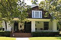
Granger 1999
A. J. and Carolina Anderson House 12591 602 E. Liberty Ave.

30°30′41″N97°40′25″W / 30.51139°N 97.67361°W / 30.51139; -97.67361

Round Rock 2001
A. M. Brown Cabin 9036 6 mi. W near RM 2243 in Garey Park Georgetown 1974FM 2243, 6 miles west of Georgetown
A.S. Mason House 13802 600 S. Bagdad Rd.

30°34′1″N97°51′58″W / 30.56694°N 97.86611°W / 30.56694; -97.86611

Leander 1983Bagdad Road, across from city park, S of FM 2243 and W of US 183
A. W. Sillure House AWSillure1.jpg 9338 1414 Ash St.

30°37′50″N97°40′23″W / 30.63056°N 97.67306°W / 30.63056; -97.67306

Georgetown 19901414 Ash St., Georgetown
Amos-Godbey House MartinAmosHouse1.jpg 15136 1408 Olive St.

30°37′53″N97°40′1″W / 30.63139°N 97.66694°W / 30.63139; -97.66694
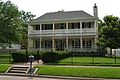
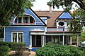
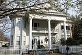
Georgetown 1988
Andrew J. Palm House Round-rock-tx2017-84(andrew-palm-house).jpg
Commons-logo.svg More images
9316 208 E. Main St.

30°30′34″N97°40′39″W / 30.50944°N 97.67750°W / 30.50944; -97.67750

Round Rock 1978Palm House Museum/Chamber of Commerce
Barker House 12298 1113 Ledbetter St.

30°30′52″N97°41′38″W / 30.51444°N 97.69389°W / 30.51444; -97.69389

Round Rock 1998
Booth House 9034 2112 W. Lake Dr.

30°34′38″N97°26′1″W / 30.57722°N 97.43361°W / 30.57722; -97.43361
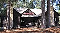
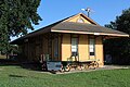
Taylor 19922112 Lake Drive, Taylor
Bryson Stagecoach Stop BrysonStageStop1.jpg 9038 SH 29, 1 mi. W

30°40′40″N97°56′37″W / 30.67778°N 97.94361°W / 30.67778; -97.94361

Liberty Hill 1981SH 29, 1 mi. W of Liberty Hill
Burcham House BurchamHouse1.jpg 9039 1310 S. College St.

30°37′54″N97°40′19″W / 30.63167°N 97.67194°W / 30.63167; -97.67194

Georgetown 19881310 College, Georgetown
C.B. and Lilburn Atkinson House AtkinsonHouse (1 of 1).jpg 13699 911 Walnut St.

30°38′8″N97°40′13″W / 30.63556°N 97.67028°W / 30.63556; -97.67028

Georgetown 2006911 S. Walnut St.
C.C. and Mattie Hughes Cody House CC and Mattie Hughes Cody House Georgetown Texas 2021.jpg 13444 304 E. University Ave.

30°37′58″N97°40′29″W / 30.63278°N 97.67472°W / 30.63278; -97.67472

Georgetown 2005304 E University
Cabin from Gabriel Mills Area Porch View Restored 1850s log cabins from Gabriel Mills, Texas.jpg 9097 3300 E. Palm Valley Blvd.

30°31′39″N97°38′4″W / 30.52750°N 97.63444°W / 30.52750; -97.63444

Round Rock 1976Building and marker moved 2005 to Old Settlers Park, Round Rock (formerly Austin Ave, Georgetown).
Caldwell-Palm House 9043 4307 Teravista Club Dr.

30°34′25″N97°40′17″W / 30.57361°N 97.67139°W / 30.57361; -97.67139
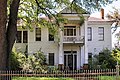
Round Rock 1965
Cooper Sansom House Cooper Sansom House Georgetown Texas 2022.jpg 14160 1252 S. Main St.

30°37′51″N97°40′38″W / 30.63083°N 97.67722°W / 30.63083; -97.67722

Georgetown 1988
David H. and Jerusha Dyches McFadin House McFadin House, Taylor, Texas.jpg
Commons-logo.svg More images
9306 FM 1331 E of SH 95

30°38′18″N97°25′33″W / 30.63833°N 97.42583°W / 30.63833; -97.42583

Circleville 1965On FM 1331, Circleville vicinity
Doak Home 9047 600 W. Seventh St.

30°34′24″N97°25′0″W / 30.57333°N 97.41667°W / 30.57333; -97.41667

Taylor 1967600 W. 7th St., Taylor
Dog Run Log Cabin 9048 S of CR 202 E of CR 207

30°43′55″N97°54′26″W / 30.73194°N 97.90722°W / 30.73194; -97.90722
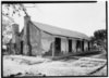
Liberty Hill 196810 mi. N of Liberty Hill via SH 29/US 183, off local road (Dr. Michael Collins property)
Early Church Early Church Florence Texas 2018.jpg 9084 100 Suttles St.

30°50′18″N97°47′21″W / 30.83833°N 97.78917°W / 30.83833; -97.78917
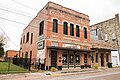
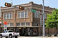
Florence 1970Primitive Baptist Church, Suttles Street, next to Florence Cemetery, Florence
Early Commercial Building Round-rock-tx2017-90(nelson-hardware).jpg
Commons-logo.svg More images
9085 203 E. Main St.

30°30′31″N97°40′39″W / 30.50861°N 97.67750°W / 30.50861; -97.67750

Round Rock 1970203 E. Main Street, Round Rock (Nelson Hardware Building)
Easley Home Easley house georgetown tx 2014.jpg 14218 1310 Olive St.

30°37′55″N97°40′2″W / 30.63194°N 97.66722°W / 30.63194; -97.66722

Georgetown 1984
Eikel-Prewitt Building 9086 316 N. Main St.

30°34′13″N97°24′34″W / 30.57028°N 97.40944°W / 30.57028; -97.40944
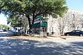
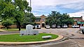
Taylor 1985316 N. Main Street, Taylor
El Milagro Historic American Buildings Survey, Arthur W. Stewart, Photographer September 10, 1936 SOUTH ELEVATION (FRONT). - Washington Anderson House, Texas Route 79 at Northeast edge of HABS TEX,246-ROURO,1-1.tif
Commons-logo.svg More images
14634 900 Heritage Center Cir.

30°30′59″N97°40′33″W / 30.51639°N 97.67583°W / 30.51639; -97.67583

Round Rock 1963Heritage Center Circle, S of US 79 and E of Mays St. Also known as the Washington Anderson House.
Farmers State Bank Building The Williamson Museum Georgetown Texas.jpg 13603 716 S. Austin Ave.

30°38′13″N97°40′42″W / 30.63694°N 97.67833°W / 30.63694; -97.67833

Georgetown 2006716 Austin Ave
First Christian Church of Taylor 9091 603 Talbot St.

30°34′22″N97°24′41″W / 30.57278°N 97.41139°W / 30.57278; -97.41139

Taylor 19706th & Talbot streets, Taylor
First Presbyterian Church 14860 703 S. Church St.

30°38′14″N97°40′33″W / 30.63722°N 97.67583°W / 30.63722; -97.67583

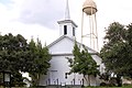
Georgetown 1962
First Presbyterian Church of Bartlett First Presbyterian Church Bartlett Wiki-1.jpg 9088 346 W. Pietzsch St.

30°47′44″N97°25′57″W / 30.79556°N 97.43250°W / 30.79556; -97.43250
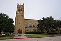
Bartlett 1970346 Pietzsch Street, Bartlett
First United Methodist Church of Georgetown FirstMethodistChurchGeorgetown.jpg 9090 410 E. University Ave.

30°37′58″N97°40′23″W / 30.63278°N 97.67306°W / 30.63278; -97.67306

Georgetown 1974University Ave. and Ash St.
George Irvine House George irvine house 2011.jpg 9111 409 E. University Ave.

30°38′0″N97°40′24″W / 30.63333°N 97.67333°W / 30.63333; -97.67333

Georgetown 1988409 E. University, Georgetown
Georgetown Fire House and Old City Hall 13918 816 S. Main St.

30°38′9″N97°40′38″W / 30.63583°N 97.67722°W / 30.63583; -97.67722

Georgetown 19849th and Main
Georgetown High School Building OldGeorgetownHighSchool1.jpg 9098 507 E. University Ave.

30°38′1″N97°40′20″W / 30.63361°N 97.67222°W / 30.63361; -97.67222
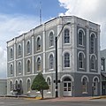
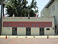
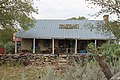
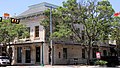
Georgetown 1988507 E. University Ave., Georgetown
Granger City Hall (Farmers State Bank) Granger Texas Former City Hall.jpg 9100 212 E. Davilla St.

30°43′2″N97°26′27″W / 30.71722°N 97.44083°W / 30.71722; -97.44083
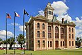
Granger 1994212 E. Davilla Street, Granger
Granger High School Granger Texas High School 2021.jpg 9101 300 N. Colorado St.

30°43′14″N97°26′13″W / 30.72056°N 97.43694°W / 30.72056; -97.43694

Granger 1991N. Colorado Street, Granger
H.C. Craig Building Georgetown Downtown 4.jpg 13874 115 W. Seventh St.

30°38′16″N97°40′40″W / 30.63778°N 97.67778°W / 30.63778; -97.67778

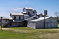
Georgetown 1990
Hall Ranch Home 14171 S of W. SH 29 beyond high school

30°40′42″N97°57′41″W / 30.67833°N 97.96139°W / 30.67833; -97.96139

Liberty Hill 1962W. of Liberty Hill on US 29, 808 Ranch
Heinatz Homestead 9104 301 N. Bagdad Rd.

30°34′30″N97°52′18″W / 30.57500°N 97.87167°W / 30.57500; -97.87167

Leander 19721 mi. W of Leander on FM 2243, 0.2 mi. S on Bagdad road
Home of A. J. Nelson 9305 N. A.W. Grimes Blvd. SE of University Blvd.

30°34′7″N97°38′45″W / 30.56861°N 97.64583°W / 30.56861; -97.64583
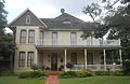
Round Rock 1965FM 1460, SE of Chandler Road (University)
J. A. McDougle Home J A McDougle Home Georgetown Texas 2021.jpg 9297 1312 Elm St.

30°37′55″N97°40′28″W / 30.63194°N 97.67444°W / 30.63194; -97.67444

Georgetown 19751312 Elm Street, Georgetown
Jesse Cooper House Jesse and Sara Cooper House.jpg
Commons-logo.svg More images
9042 Wilbarger Point, off SH 29, 1.5 mi. E

30°38′32″N97°38′48″W / 30.64222°N 97.64667°W / 30.64222; -97.64667

Georgetown 1988Wilbarger Point, north of SH 29, just west of NE Inner Loop
John G. Matthews House 9296 N of CR 263 E of Metrorail tracks

30°38′28″N97°52′51″W / 30.64111°N 97.88083°W / 30.64111; -97.88083

Liberty Hill 1976on private road 1 mile west of US 183, 3.5 miles southeast of Liberty Hill
Lesesne-Stone Building Lesesne Stone Building Georgetown Texas 2022.jpg 13916 102 W. Eighth St.

30°38′11″N97°40′38″W / 30.63639°N 97.67722°W / 30.63639; -97.67722

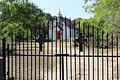
Georgetown 1983
Liberty Hill Masonic Hall Masonic Hall, Liberty Hill, Texas (8632756919).jpg
Commons-logo.svg More images
9291 927 Main St.

30°39′50″N97°55′20″W / 30.66389°N 97.92222°W / 30.66389; -97.92222
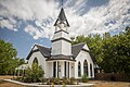
Liberty Hill 1976Main Street, Liberty Hill
Liberty Hill United Methodist Church 9292 101 Church St.

30°39′53″N97°55′8″W / 30.66472°N 97.91889°W / 30.66472; -97.91889

Liberty Hill 19621 block N of Main Street (Loop 332), Liberty Hill
M.B. Lockett Building M.B. Lockett Building, Georgetown, TX IMG 7115.JPG
Commons-logo.svg More images
13873 119 W. Seventh St.

30°38′16″N97°40′40″W / 30.63778°N 97.67778°W / 30.63778; -97.67778

Georgetown 1991
M.B. Norman House 16563 12500 FM 1660

30°30′0″N97°30′13″W / 30.50000°N 97.50361°W / 30.50000; -97.50361

Taylor 2010Norman's Crossing
Marsh F. Smith House Marsh F Smith House Georgetown Texas 2022.jpg 9340 1242 S. Austin Ave.

30°37′53″N97°40′42″W / 30.63139°N 97.67833°W / 30.63139; -97.67833
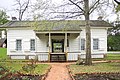
Georgetown 19881242 Austin Ave., Georgetown
Nelson-Crier House 9308 405 E. Main St.

30°30′33″N97°40′30″W / 30.50917°N 97.67500°W / 30.50917; -97.67500

Round Rock 1973405 E Main St
Old Broom Factory Building 9035 100 E. Main St.

30°30′32″N97°40′43″W / 30.50889°N 97.67861°W / 30.50889; -97.67861

Round Rock 1970corner of Mays & Main Streets, Round Rock
Old Dimmitt Building Old Dimmitt Building Georgetown Texas 2022.jpg 13920 801 S. Main St.

30°38′11″N97°40′36″W / 30.63639°N 97.67667°W / 30.63639; -97.67667

Georgetown 1965
Old Dimmitt Home John dimmitt house 2013.jpg 13921 921 W. University Ave.

30°38′5″N97°41′12″W / 30.63472°N 97.68667°W / 30.63472; -97.68667

Georgetown 1967921 W. University (SH 29)
Olson House 12913 808 E. Main St.

30°30′40″N97°40′15″W / 30.51111°N 97.67083°W / 30.51111; -97.67083

Round Rock 2000808 E. Main St.
Page-Decrow-Weir House Paige decrow weir house 2008.jpg 9370 1903 J.M. Page Ln.

30°37′24″N97°41′30″W / 30.62333°N 97.69167°W / 30.62333; -97.69167

Georgetown 1988N of FM 2243 (Leander Road) on W side of IH-35, Georgetown
Palm Valley Lutheran Church 9317 2500 E. Palm Valley Blvd.

30°31′20″N97°38′44″W / 30.52222°N 97.64556°W / 30.52222; -97.64556

Round Rock 19702500 Palm Valley Blvd
Pickle-Mason House 9321 11332 Hero Way W.

30°34′50″N97°51′40″W / 30.58056°N 97.86111°W / 30.58056; -97.86111

Leander 1988FM 2243, 0.4 mi. W of US 183
Pioneers' House 9323 N of San Gabriel Pkwy. E of 183A

30°35′53″N97°51′7″W / 30.59806°N 97.85194°W / 30.59806; -97.85194
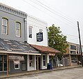
Leander 1970(Bryson Home)
Preslar-Hewitt Building Preslar hewitt building 2013.jpg 13070 321 N. Main St.

30°34′13″N97°24′35″W / 30.57028°N 97.40972°W / 30.57028; -97.40972

Taylor 2004321 N. Main Street
Shafer Saddlery Shafer Saddlery Georgetown Texas 2022.jpg 13882 711 S. Main St.

30°38′13″N97°40′36″W / 30.63694°N 97.67667°W / 30.63694; -97.67667

Georgetown 1971
Shiloh Baptist Church 9337 100 CR 481

30°29′30″N97°12′13″W / 30.49167°N 97.20361°W / 30.49167; -97.20361

Taylor vicinity1968On building on FM 112/CR 15, 15 miles southeast of Taylor
Sloan House 15507 13574 SH 29

30°38′10″N97°28′29″W / 30.63611°N 97.47472°W / 30.63611; -97.47472

Taylor 1965Hwy 29, 8 mi. NW of Taylor
Smart-McCormick Home 13803 1251 CR 208

30°48′19″N97°55′13″W / 30.80528°N 97.92028°W / 30.80528; -97.92028

Andice 19654.5 mi. NW of Andice
Southwestern University Administration Building Rutlo 3772831372 Southwestern.jpg
Commons-logo.svg More images
9342 1001 E. University Ave.

30°38′0″N97°40′1″W / 30.63333°N 97.66694°W / 30.63333; -97.66694
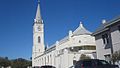
Georgetown 19621000 E. University Ave. (SH 29), Georgetown
St. James Church 9334 612 Davis St.

30°34′23″N97°24′53″W / 30.57306°N 97.41472°W / 30.57306; -97.41472

Taylor 1969corner of Davis and W 7th St
St. Peters United Church of Christ St-peters-united-church-of-christ(coupland-tx)2016-2.jpg
Commons-logo.svg More images
9335 108 Wathen St.

30°27′29″N97°23′28″W / 30.45806°N 97.39111°W / 30.45806; -97.39111

Coupland 1989Wathen and Broad Streets
Steele Store-Makemson Hotel Building Steele Store Makemson Hotel Building Georgetown Texas 2022.jpg 13881 802 S. Austin Ave.

30°38′11″N97°40′42″W / 30.63639°N 97.67833°W / 30.63639; -97.67833
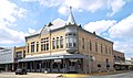
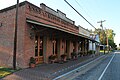
Georgetown 19888th and Austin Ave
Stubblefield Building Stubblefield Building, Liberty Hill, Texas (8636273076).jpg
Commons-logo.svg More images
12998 1002 Main St.

30°39′52″N97°55′20″W / 30.66444°N 97.92222°W / 30.66444; -97.92222

Liberty Hill 1976Main St. at Myrtle
Taylor National Bank Taylor national bank 2013.jpg 9354 200 N. Main St.

30°34′7″N97°24′33″W / 30.56861°N 97.40917°W / 30.56861; -97.40917

Taylor 1980
Taylor Post Office U.S. Post Office in Taylor, TX IMG 2228.JPG 9359 202 W. Fourth St.

30°34′15″N97°24′40″W / 30.57083°N 97.41111°W / 30.57083; -97.41111

Taylor 1992202 W. Fourth Street, Taylor
The David Love Store David Love Store Georgetown Texas 2022.jpg 13674 706 S. Austin Ave.

30°38′14″N97°40′42″W / 30.63722°N 97.67833°W / 30.63722; -97.67833
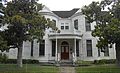
Georgetown 1988706 Austin Ave
The G. W. Riley House LaneRileyHouse1.jpg 9328 1302 S. College St.

30°37′55″N97°40′19″W / 30.63194°N 97.67194°W / 30.63194; -97.67194

Georgetown 19721302 College St
The Harrell-Stone House The Harrell Stone House Georgetown Texas 2021.jpg 9103 1404 Elm St.

30°37′53″N97°40′28″W / 30.63139°N 97.67444°W / 30.63139; -97.67444

Georgetown 19761404 Elm Street, Georgetown
Tucker-Smith House 9366 516 W. Seventh St.

30°34′24″N97°24′58″W / 30.57333°N 97.41611°W / 30.57333; -97.41611

Taylor 1991516 W. 7th Street, Taylor
United Methodist Church 15212 201 S. Granger St.

30°42′59″N97°26′30″W / 30.71639°N 97.44167°W / 30.71639; -97.44167

Granger 1970
W.C. Vaden House Vaden house georgetown tx 2014.jpg 13897 711 E. University Ave.

30°38′1″N97°40′13″W / 30.63361°N 97.67028°W / 30.63361; -97.67028

Georgetown 1992
W. Y. Penn Home W Y Penn Home Georgetown Texas 2021.jpg 9318 1304 Elm St.

30°37′56″N97°40′28″W / 30.63222°N 97.67444°W / 30.63222; -97.67444

Georgetown 19751304 Elm St
Washington Bower 9367 CR  479 W of CR 492

30°29′57″N97°13′54″W / 30.49917°N 97.23167°W / 30.49917; -97.23167

Taylor 197115 mi. SE of Taylor on FM 112 to CR 479
Wesley Chapel A.M.E. Church WesleyChapelAMEChurch.jpg 13895 508 W. Fourth St.

30°38′24″N97°40′53″W / 30.64000°N 97.68139°W / 30.64000; -97.68139

Georgetown 1984
Wessels, T. F., Home 14169 1002 N. Mays St.

30°30′59″N97°41′2″W / 30.51639°N 97.68389°W / 30.51639; -97.68389
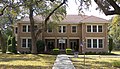
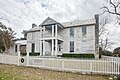
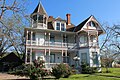
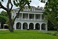
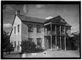
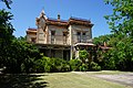
Round Rock 1963on campus of First United Methodist Church
William M. Owen House Complex William owen house 2008.jpg
Commons-logo.svg More images
9315 900 Chisholm Trail Rd.

30°30′55″N97°41′24″W / 30.51528°N 97.69000°W / 30.51528; -97.69000
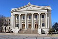
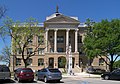
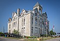
Round Rock 1982900 Chisholm Trail Rd
Williamson County Courthouse # Williamson county courthouse 2008.jpg
Commons-logo.svg More images
13880 710 S. Main St.

30°38′13″N97°40′39″W / 30.63694°N 97.67750°W / 30.63694; -97.67750
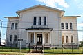
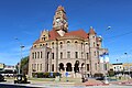
Georgetown 1988Williamson County Courthouse grounds
Williamson County Jail Williamson County Jail Georgetown Texas 2022.jpg 14481 312 S. Main St.

30°38′25″N97°40′39″W / 30.64028°N 97.67750°W / 30.64028; -97.67750

Georgetown 1965
Young House 9372 500 E. Davilla St.

30°43′1″N97°26′17″W / 30.71694°N 97.43806°W / 30.71694; -97.43806

Granger 1991532 E. Davilla, Granger

Wilson County

Registered Texas Historic LandmarkImageMarker numberPhysical addressNearest cityYear designatedDescription
Albert Kosub House 100 1230 Hill Top Ln.

29°24′39″N98°7′58″W / 29.41083°N 98.13278°W / 29.41083; -98.13278

LaVernia 1963From 1346 turn left at first gravel road, about 4 miles, take a right, go about 1/2 mile, go left until approach mailboxes, proceed straight up driveway/dirt road to home.
Barker-Huebinger House 14192 13309 FM 539

29°20′35″N98°3′38″W / 29.34306°N 98.06056°W / 29.34306; -98.06056

Sutherland Springs 2008
Brahan Lodge #226, A.F. & A.M. La-vernia-tx2016-13(brahan-lodge).jpg
Commons-logo.svg More images
487 121 Bluebonnet Dr.

29°21′14″N98°7′7″W / 29.35389°N 98.11861°W / 29.35389; -98.11861

LaVernia 1962FM 775, southwest of US 87
Bridge at McAlister Crossing (Mueller Bridge) (2/10 mi. SW) Bridge(mcalister-crossing)(mueller-bridge)2016-3.jpg
Commons-logo.svg More images
13258 FM 539, CR 337

29°21′5″N98°4′28″W / 29.35139°N 98.07444°W / 29.35139; -98.07444

LaVernia 2004SE of town at intersection of FM 539 and CR 337. Marker reported missing Mar. 2008.
Cemetery of Canary Islanders 701 700 Tenth St.

29°8′56″N98°9′31″W / 29.14889°N 98.15861°W / 29.14889; -98.15861

Floresville 1967Marker is at NE corner of 10th and Plum Streets, facing 10th Street (US 181). Cemetery is behind O'Reilly Auto Parts and AutoZone.
Charles Carl Winkler House 812 0.25 mi. from Bexar County line S of FM 1346

29°22′36″N98°11′0″W / 29.37667°N 98.18333°W / 29.37667; -98.18333

LaVernia 1963Take 1346 north out of La Vernia to the Carpenter Community located at Wilson/Bexar County Line. House is on left 1/4 mile from County Line. Located behind new Winkler family about 300 feet off highway.
King-Lorenz House 2953 303 S. Seventh St.

29°14′0″N97°57′42″W / 29.23333°N 97.96167°W / 29.23333; -97.96167

Stockdale 1984Located on 7th Street, 3 blocks south of Main Street, Stockdale.
White House Café and Saloon White House Floresville Texas (1 of 1).jpg 12828 1307 Third St.

29°8′3″N98°9′33″W / 29.13417°N 98.15917°W / 29.13417; -98.15917

Floresville 20021307 3rd St.
Whitehall DecembertripWhitehall1 (1 of 1).jpg
Commons-logo.svg More images
13807 FM 539

29°19′2″N98°3′28″W / 29.31722°N 98.05778°W / 29.31722; -98.05778

Sutherland Springs 1962three miles north of Sutherland Springs on FM 539 (Polley Mansion)
Wilson County Courthouse # Wilson County Courthouse RAW9238-S.jpg
Commons-logo.svg More images
5856 1420 Third St.

29°8′0″N98°9′27″W / 29.13333°N 98.15750°W / 29.13333; -98.15750

Floresville 19841420 Third Street, Floresville.
Yndo Ranch Historic American Buildings Survey, Arthur W. Stewart, Photographer March 20, 1936 NORTHEAST ELEVATION (NORTH FRONT AND EAST SIDE). - Miguel Yndo House, Farm Road 1303, HABS TEX,247- ,1-1.tif
Commons-logo.svg More images
4159 FM 1303 E of FM 775

29°11′40″N98°16′23″W / 29.19444°N 98.27306°W / 29.19444; -98.27306

Floresville 1964From Floresville, 3 mi. W on FM 536, then 7 mi. NW on FM 1303, near intersection with FM 775

Winkler County

Registered Texas Historic LandmarkImageMarker numberPhysical addressNearest cityYear designatedDescription
Kermit's Oldest Home 2928 2100 Tommy Thompson Rd.

31°51′24″N103°4′45″W / 31.85667°N 103.07917°W / 31.85667; -103.07917

Kermit 1964Pioneer Park, Tommy Thompson Rd., Kermit (Mosley House)
Texas Territorial Compromise of 1850 5274 SH 18 at New Mexico state line N of Kermit

31°59′58″N103°7′58″W / 31.99944°N 103.13278°W / 31.99944; -103.13278

Kermit 1966From Kermit, take SH 18 North then at State Line.
The Community Church 1005 302 S. Poplar St.

31°51′20″N103°5′34″W / 31.85556°N 103.09278°W / 31.85556; -103.09278

Kermit 1966302 South Poplar St., Kermit
The Sand Hills 4561 SH 115 beyond FM 874 NE of Kermit

31°57′43″N102°57′55″W / 31.96194°N 102.96528°W / 31.96194; -102.96528

Kermit 1967From Kermit, take SH 115 NE about 8 mile Junction N of FM 874.
Wink Junior High and High School 17754 200 N. Rosey Dodd Ave.

31°45′18″N103°9′8″W / 31.75500°N 103.15222°W / 31.75500; -103.15222

Wink 2012Wink's lone historical marker is soon to be recalled due to pending demolition of the historic structure passed by superintendent Scotty Carman and the WLISD school board.
Winkler County Courthouse County courthouse for Winkler County, near the New Mexico line in far-west Texas LCCN2014630676.tif 5867 110 E. Winkler St.

31°51′26″N103°5′37″W / 31.85722°N 103.09361°W / 31.85722; -103.09361

Kermit 1988110 E. Winkler St., Kermit

Wise County

Registered Texas Historic LandmarkImageMarker numberPhysical addressNearest cityYear designatedDescription
Decatur Baptist College Decatur Baptist College Wiki (1 of 1).jpg
Commons-logo.svg More images
1197 1602 S. Trinity St.

33°13′22″N97°35′11″W / 33.22278°N 97.58639°W / 33.22278; -97.58639

Decatur 1964At south end of Trinity Street, Decatur
El Castile (Old Waggoner Home) Decatur June 2018 20 (Waggoner Mansion).jpg
Commons-logo.svg More images
4 1003 E. Main St.

33°14′3″N97°34′37″W / 33.23417°N 97.57694°W / 33.23417; -97.57694

Decatur 19621000 E. Main St., Decatur
Episcopal Mission of the Ascension Decatur June 2018 25 (Episcopal Church of the Resurrection).jpg
Commons-logo.svg More images
1492 905 S. Church St.

33°13′42″N97°35′7″W / 33.22833°N 97.58528°W / 33.22833; -97.58528

Decatur 1968S. Church & Hale Streets, Decatur
Greenwood Masonic Lodge #779 Greenwood Masonic Lodge -779 Wiki (1 of 1).jpg 18394 147 CR 2640

33°22′49″N97°28′27″W / 33.38028°N 97.47417°W / 33.38028; -97.47417

Decatur 2016147 County Road 2640 {Corner of CR 2640 (old Main Street) and Farm to Market Road 1204} Decatur (Greewood), Texas 76234
Hanna-Robinson-Richey Drugstore Old Drugstore, Chico, Texas (8858809324).jpg
Commons-logo.svg More images
2364 104 Jacksboro St.

33°17′42″N97°47′52″W / 33.29500°N 97.79778°W / 33.29500; -97.79778

Chico 1976Jacksboro Street (near Buffalo Street, on public square), Chico
Masonic Lodge #479 3244 128 W. Rock Island Ave.

33°4′42″N97°33′58″W / 33.07833°N 97.56611°W / 33.07833; -97.56611

Boyd 1965S. Evans at W. Rock Island, Boyd
Old Stone Prison Decatur June 2018 14 (Old Stone Prison).jpg
Commons-logo.svg More images
3821 201 E. Pecan St.

33°14′0″N97°35′9″W / 33.23333°N 97.58583°W / 33.23333; -97.58583

Decatur 1968201 E. Pecan Street
Perrin Log Cabin 17690 Confluence of Center Creek with Martin Branch

33°11′24″N97°36′8″W / 33.19000°N 97.60222°W / 33.19000; -97.60222

Decatur 2013
R. C. Mount House R.C.Mount Chico Wiki (1 of 1).jpg 4151 1 mi. N on Mount St.

33°18′47″N97°47′31″W / 33.31306°N 97.79194°W / 33.31306; -97.79194

Chico 1975From Chico, take Mount Street 1 mile north.
S. W. Tilghman House Decatur June 2018 19 (S. W. Tilghman House).jpg
Commons-logo.svg More images
4404 309 E. Shoemaker St.

33°13′58″N97°35′2″W / 33.23278°N 97.58389°W / 33.23278; -97.58389

Decatur 1974309 E Shoemaker. Replaced 2007.
Sam Woody's Cabin Sam Woody's Cabin Wiki (1 of 1).jpg 4509 5 mi. S of US 81/US 287 on CR 4227

33°7′35″N97°31′28″W / 33.12639°N 97.52444°W / 33.12639; -97.52444

Decatur 1970From Decatur, take US 81/87 about 3 miles south to CR 4227; follow 4227 about 5 miles south to marker at cabin.
Texas Tourist Camp Complex Texas Tourist Camp (1 of 1).jpg
Commons-logo.svg More images
5275 900-904 S. US 81/US 287

33°13′42″N97°34′44″W / 33.22833°N 97.57889°W / 33.22833; -97.57889

Decatur 1994900-904 US 81/87 south -Decatur
Wise County Courthouse# Wise County Courthouse Decatur, TX.JPG
Commons-logo.svg More images
5874 101 N. Trinity St.

33°14′3″N97°35′13″W / 33.23417°N 97.58694°W / 33.23417; -97.58694

Decatur 1964Northwest entrance of Courthouse, State & Walnut Streets

Wood County

Registered Texas Historic LandmarkImageMarker numberPhysical addressNearest cityYear designatedDescription
Callaway House 16887 512 Sycamore St.

32°40′4″N95°29′31″W / 32.66778°N 95.49194°W / 32.66778; -95.49194

Mineola 2011
Carlock Home Carlockhouse1.jpg 8949 407 S. Main St.

32°57′13″N95°17′29″W / 32.95361°N 95.29139°W / 32.95361; -95.29139

Winnsboro 1966407 S. Main St., Winnsboro
Central Christian Church (Disciples of Christ) of Winnsboro 8950 110 Sage St.

32°57′38″N95°17′27″W / 32.96056°N 95.29083°W / 32.96056; -95.29083

Winnsboro 1980110 Sage Street, Winnsboro
Collins-Haines Home 8953 Horton St. SE of Nathan Dr.

32°47′10″N95°26′31″W / 32.78611°N 95.44194°W / 32.78611; -95.44194

Quitman 19651/2 mile SE of Quitman on FM 778 (Horton Street)
Corbitt Home 11670 13 mi. SE off FM 2088 Winnsboro 196213 mi. SE of Winnsboro, off FM 2088
First National Bank Building Mineola May 2018 20 (Mineola Chamber of Commerce).jpg 12771 101 E. Broad St.

32°39′50″N95°29′21″W / 32.66389°N 95.48917°W / 32.66389; -95.48917

Mineola 2001101 E. Broad
James Stephen Hogg's Early Home 8962 518 S. Main St.

32°47′28″N95°27′12″W / 32.79111°N 95.45333°W / 32.79111; -95.45333

Quitman 1962In Gov. Jim Hogg City Park
Lankford-Stinson House 8972 307 W. Elm St.

32°57′33″N95°17′36″W / 32.95917°N 95.29333°W / 32.95917; -95.29333

Winnsboro 1988307 W. Elm Street, Winnsboro
Lott House Mineola May 2018 10 (Howard L. and Vivian W. Lott House).jpg
Commons-logo.svg More images
8976 311 E. Kilpatrick St.

32°39′50″N95°29′9″W / 32.66389°N 95.48583°W / 32.66389; -95.48583

Mineola 1996311 E. Kilpatrick Street, Mineola
Mineola Post Office Mineola May 2018 07 (Mineola Historical Museum).jpg
Commons-logo.svg More images
11664 114 N. Pacific St.

32°39′50″N95°29′15″W / 32.66389°N 95.48750°W / 32.66389; -95.48750

Mineola 1999114 N. Pacific Street, Mineola
O. P. Pyle House 9019 123 N. Line St.

32°39′54″N95°29′25″W / 32.66500°N 95.49028°W / 32.66500; -95.49028

Mineola 1982123 N. Line Street, Mineola
Old Bailey Hotel 8948 111 E. Front St.

32°39′42″N95°29′21″W / 32.66167°N 95.48917°W / 32.66167; -95.48917

Mineola 1980111 Front St. BUILDING RAZED 2001, MARKER REMOVED
Reneau Building 17729 703 FM 1799

32°43′48″N95°33′41″W / 32.73000°N 95.56139°W / 32.73000; -95.56139

Golden 2013
The Cathey Buildings 17208 100 blk. W. Lipscomb St. at N. Stephens St.

32°47′47″N95°27′9″W / 32.79639°N 95.45250°W / 32.79639; -95.45250

Quitman 2012West end of the North side of the public square in Quitman
Williams Medical Clinic Building 17223 415 W. Kilpatrick St.

32°39′54″N95°29′35″W / 32.66500°N 95.49306°W / 32.66500; -95.49306

Mineola 2012
Wood County Courthouse Wood courthouse tx 2010.jpg 13752 100 S. Main St.

32°47′45″N95°27′8″W / 32.79583°N 95.45222°W / 32.79583; -95.45222

Quitman 2003Main Street

Yoakum County

Registered Texas Historic LandmarkImageMarker numberPhysical addressNearest cityYear designatedDescription
Bonus Shack 3325 1109 B Ave. H

33°11′14″N102°49′37″W / 33.18722°N 102.82694°W / 33.18722; -102.82694

Plains 19621109 B Avenue H, Plains

Young County

Registered Texas Historic LandmarkImageMarker numberPhysical addressNearest cityYear designatedDescription
A. B. Medlan Home Graham A.B. Medlan House (1 of 1).jpg 48 Lower Tonk Valley Rd.

33°2′18″N98°36′59″W / 33.03833°N 98.61639°W / 33.03833; -98.61639

Graham 1964Take SH 67 south about 5 miles then left on county road about 5 mi. (Private, no Access)
Dr. & Mrs. J.W. Gallaher House 16581 616 East St.

33°6′18″N98°35′5″W / 33.10500°N 98.58472°W / 33.10500; -98.58472

Graham 2010616 East Street
Early Church of Graham 1339 701 Grove St.

33°6′16″N98°35′34″W / 33.10444°N 98.59278°W / 33.10444; -98.59278

Graham 1971701 Grove St., Graham
Episcopal Parish Church 1493 3128 Park Road 36

32°53′17″N98°27′59″W / 32.88806°N 98.46639°W / 32.88806; -98.46639

Graham 1962South on Possum Kingdom Lake, Graham; (now the Holy Spirit Church of Graham)
Fort Belknap Fort Belknap Colonel Young.jpg
Commons-logo.svg More images
1959 3 mi. S of Newcastle W of FM 61

33°9′3″N98°44′29″W / 33.15083°N 98.74139°W / 33.15083; -98.74139

Newcastle 1962SH 251, from Newcastle, about 3 mi south
Graham Post Office GrahamPostOffice1.JPG 13743 510 Third St.

33°6′20″N98°35′27″W / 33.10556°N 98.59083°W / 33.10556; -98.59083

Graham 1999510 Third St.
Lewis Pinkney Brooks Home 3078 Pinkney Brooks Rd. 1 mi. W of SH 209

33°4′19″N98°43′42″W / 33.07194°N 98.72833°W / 33.07194; -98.72833

Graham 1965From Graham, take Hwy. 209 west about 8 mi (Loc. near old McCambridge) to Local road (Pinkey Brooks Rd), Follow one mi. to house.
Medlan Chapel Primitive Baptist Church Graham Medlan Chapel Primitive Baptist Church (1 of 1).jpg 3317 Medlan Chapel Rd. W of SH 67

33°4′31″N98°41′41″W / 33.07528°N 98.69472°W / 33.07528; -98.69472

Graham 1965From Graham, take SH 67 south about 3 mi then follow Canty Road west about 5 mi.
Old Fort Belknap Powder Magazine Fort Belknap Powder Magazine.jpg
Commons-logo.svg More images
3729 N of Fort Cir. W of FM 61

33°9′6″N98°44′27″W / 33.15167°N 98.74083°W / 33.15167; -98.74083

Newcastle 1962From Newcastle, take SH 251 south about 3 mi to Ft. Belknap
Ryus Store Building Downtown Graham Texas Ryus Store Building (1 of 1).jpg 4398 608 Oak St.

33°6′19″N98°35′30″W / 33.10528°N 98.59167°W / 33.10528; -98.59167

Graham 1974608 Oak St., Graham

Zapata County

Registered Texas Historic LandmarkImageMarker numberPhysical addressNearest cityYear designatedDescription
Jesus Trevino Home Jesus Trevino Fort.jpg
Commons-logo.svg More images
5556 Jct. Trevino St. and Uribe St.

27°2′42″N99°26′36″W / 27.04500°N 99.44333°W / 27.04500; -99.44333

San Ygnacio 1964At Trevino & Uribe Avenues, San Ygnacio.

Zavala County

Currently, no Recorded Texas Historic Landmarks are listed within the county.

See also

Recorded Texas Historic Landmarks listed by county
Anderson-CallahanCameron-DuvalEastland-GrayGrayson-HudspethHunt-MartinMason-RuskSabine-Travis • Trinity-Zavala

Related Research Articles

<span class="mw-page-title-main">National Register of Historic Places listings in Tom Green County, Texas</span>

The following properties are listed on the National Register of Historic Places in Tom Green County, Texas.

<span class="mw-page-title-main">National Register of Historic Places listings in Bexar County, Texas</span>

This is a list of the National Register of Historic Places listings in Bexar County, Texas.

<span class="mw-page-title-main">National Register of Historic Places listings in Tarrant County, Texas</span>

This is a list of the National Register of Historic Places listings in Tarrant County, Texas.

<span class="mw-page-title-main">National Register of Historic Places listings in Lamar County, Texas</span>

This is a list of the National Register of Historic Places listings in Lamar County, Texas.

<span class="mw-page-title-main">National Register of Historic Places listings in Robertson County, Texas</span>

This is a list of the National Register of Historic Places listings in Robertson County, Texas.

<span class="mw-page-title-main">National Register of Historic Places listings in Brown County, Texas</span>

This is a list of the National Register of Historic Places listings in Brown County, Texas.

<span class="mw-page-title-main">National Register of Historic Places listings in Hidalgo County, Texas</span>

This is a list of the National Register of Historic Places listings in Hidalgo County, Texas

<span class="mw-page-title-main">National Register of Historic Places listings in Medina County, Texas</span>

This is a list of the National Register of Historic Places listings in Medina County, Texas.

<span class="mw-page-title-main">National Register of Historic Places listings in Llano County, Texas</span>

This is a list of the National Register of Historic Places listings in Llano County, Texas.

<span class="mw-page-title-main">National Register of Historic Places listings in Walker County, Texas</span>

This is a list of the National Register of Historic Places listings in Walker County, Texas.

<span class="mw-page-title-main">National Register of Historic Places listings in Young County, Texas</span>

This is a list of the National Register of Historic Places listings in Young County, Texas.

<span class="mw-page-title-main">National Register of Historic Places listings in Parker County, Texas</span>

This is a list of the National Register of Historic Places listings in Parker County, Texas.

<span class="mw-page-title-main">National Register of Historic Places listings in Eastland County, Texas</span>

This is a list of the National Register of Historic Places listings in Eastland County, Texas.

References

    Commons-logo.svg Media related to Recorded Texas Historic Landmarks at Wikimedia Commons