Electra, Texas

Last updated

Electra, Texas
Daddy-Long-Legs (1919) - Liberty Theater, Electra, Texas.jpg
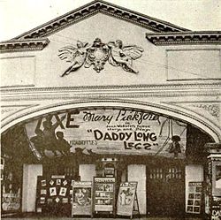
Liberty Theater, Electra, showing a Mary Pickford movie in 1919.
Motto: 
"Wichita County's Best Kept Secret"
TXMap-doton-Electra.PNG
Location of Electra, Texas
Wichita County Electra.svg
Coordinates: 34°01′57″N98°55′12″W / 34.03250°N 98.92000°W / 34.03250; -98.92000
Country United States
State Texas
County Wichita
Area
[1]
  Total3.08 sq mi (7.98 km2)
  Land3.08 sq mi (7.97 km2)
  Water0.00 sq mi (0.01 km2)
Elevation
[2]
1,227 ft (374 m)
Population
 (2010)
  Total2,791
  Estimate 
(2019) [3]
2,730
  Density887.23/sq mi (342.54/km2)
Time zone UTC-6 (Central (CST))
  Summer (DST) UTC-5 (CDT)
ZIP code
76360
Area code 940
FIPS code 48-22984 [4]
GNIS feature ID2410419 [2]
Website www.electratexas.org
55, 000 bbl Oil Tank struck by lightning. Aug. 5, 1912, Electra, Texas P. F. Co.'s 55, 000 Oil Tank struck by lightning Aug. 5, 1912, Electra, Texas (7489933702).jpg
55, 000 bbl Oil Tank struck by lightning. Aug. 5, 1912, Electra, Texas

Electra is a city in Wichita County, Texas, United States. It is part of the Wichita Falls metropolitan statistical area. The population was 2,791 at the 2010 census., [5] down from 3,168 in 2000. Electra claims the title of Pump Jack Capital of Texas, a title made official by the state in 2001, [6] and has celebrated an annual Pump Jack Festival since 2002. [7] It was named in honor of Electra Waggoner, an heiress to the Waggoner Ranch. [8] Electra is also known for its Grand Theatre which was refurbished and now a functioning theater.

Contents

History

Daniel Waggoner started a ranch in present-day Electra in 1852. Around 30 years later, the Fort Worth and Denver Railway was built, and its railroad tracks ran through the area. In 1885, Waggoner's son, William Thomas Waggoner, successfully lobbied railroad executives to build a railroad station at the site. By this time, the Waggoner ranch covered a half-million acres. Until this time, the town was called Waggoner, but following the building of the station and a post office in 1889, it was dubbed Beaver Switch, after the nearby Beaver Creek. The opening of 56,000 acres (230 km2) of land north of the railroad station brought more farmers to the area. The town was renamed again in 1907, this time after Waggoner's daughter, Electra Waggoner.

Water can be scarce in this region of Texas, so Waggoner started drilling for water for the town's new residents. Most of these drilling sites were befouled by crude oil, which made the water unfit for drinking. Three years later, a developer from Fort Worth named Solomon Williams bought the land from Waggoner. Soon thereafter, he annexed nearby land, subdivided the land, and placed advertisements in national media trying to increase the population. His efforts were successful, and the town grew from a population of 500 to 1,000 between 1907 and 1910. The Waggoner family still owns much of the same land they did in the beginning and still drills for oil there.

In 1911, the Electra Independent School District was created.

On 1 April 1911, the Clayco Oil gusher brought in an oil strike at a depth of 1,600 feet (490 m), producing 260 barrels of oil per day (BOPD). Word spread quickly, and the population increased to over 1,000, with many more oil workers commuting from Wichita Falls. The town soon had brick buildings, cement sidewalks, and a telephone exchange. [9]

In 1936, Electra had well over 6,000 residents, but by the 1960s, the population had decreased to just over 5,000. The Dallas-Fort Worth Metroplex was growing, and many people moved away. By 2000, Electra's population had fallen to about 3,000.

Geography

Electra is located at 34°1′51″N98°55′2″W / 34.03083°N 98.91722°W / 34.03083; -98.91722 (34.030809, –98.917281). [10] According to the United States Census Bureau, the city has a total area of 2.4 mi2 (6.3 km2), all land.

Demographics

Historical population
CensusPop.Note
1910 640
1920 4,744641.3%
1930 6,71241.5%
1940 5,588−16.7%
1950 4,970−11.1%
1960 4,759−4.2%
1970 3,895−18.2%
1980 3,755−3.6%
1990 3,113−17.1%
2000 3,1681.8%
2010 2,791−11.9%
2019 (est.)2,730 [3] −2.2%
U.S. Decennial Census [11]
Electra racial composition as of 2020 [12]
(NH = Non-Hispanic) [lower-alpha 1]
RaceNumberPercentage
White (NH)1,72275.13%
Black or African American (NH)1144.97%
Native American or Alaska Native (NH)120.52%
Asian (NH)110.48%
Some Other Race (NH)50.22%
Mixed/Multi-Racial (NH)1195.19%
Hispanic or Latino 30913.48%
Total2,292

As of the 2020 United States census, there were 2,292 people, 1,253 households, and 606 families residing in the city.

Education

The City of Electra is served by the Electra Independent School District, which is composed of 210 sq mi (540 km2).

The three public schools are: B.M. Dinsmore Elementary School, with 225 students enrolled in prekindergarten through fourth grade; Electra Junior High with 172 students in grades five through eight; and Electra High School with 149 students enrolled in ninth through 12th grades. Electra High School's athletic teams are called the Tigers. The student/teacher ratio at each of the schools is 14:1, 13:1, and 9:1, respectively.

Notable Persons

Climate

The climate in this area is characterized by hot, humid summers and generally mild to cool winters. According to the Köppen climate classification system, Electra has a humid subtropical climate, Cfa on climate maps. [17]

Utilities

Related Research Articles

<span class="mw-page-title-main">Winkler County, Texas</span> County in Texas, United States

Winkler County is a county in the U.S. state of Texas. As of the 2020 census, its population was 7,791. Its county seat is Kermit. The county was created in 1887 and organized in 1910. It is named for Clinton McKamy Winkler, a colonel in the Confederate Army.

<span class="mw-page-title-main">Reagan County, Texas</span> County in Texas, United States

Reagan County is a county on the Edwards Plateau in the U.S. state of Texas. As of the 2020 census, its population was 3,385. The county seat is Big Lake. The county is named after John Henninger Reagan (1818–1905), who was the postmaster general of the Confederate States and also a U.S. senator, U.S. representative, and first chairman of the Railroad Commission of Texas.

<span class="mw-page-title-main">Crockett County, Texas</span> County in Texas, United States

Crockett County is a county located on the Edwards Plateau in the U.S. state of Texas. As of the 2020 census, its population was 3,098. The county seat is Ozona. The county was founded in 1875 and later organized in 1891. It is named in honor of Davy Crockett, the legendary frontiersman who died at the Battle of the Alamo.

<span class="mw-page-title-main">Holliday, Texas</span> City in Texas, United States

Holliday is a city in Archer County, Texas, United States. It is part of the Wichita Falls, Texas Metropolitan Statistical Area. The population was 1,758 at the 2010 census. The town is named for nearby Holliday Creek, named in turn for John Holliday, a member of a Republic of Texas military expedition.

<span class="mw-page-title-main">Megargel, Texas</span> Town in Texas, United States

Megargel is a town in Archer County, Texas, United States. It is part of the Wichita Falls, Texas metropolitan statistical area. Its population was 203 at the 2010 census. The town is named for Roy C. Megargel, the president of the railroad that developed the town.

<span class="mw-page-title-main">Henrietta, Texas</span> City in Texas, United States

Henrietta is a city in and the county seat of Clay County, Texas, United States. It is part of the Wichita Falls metropolitan statistical area. The population was 3,141 at the 2010 census, a decline of 123 from the 2000 tabulation of 3,264.

<span class="mw-page-title-main">Ranger, Texas</span> City in Texas, United States

Ranger is a city in Eastland County, Texas, United States. Its population was 2,468 at the 2010 census. Ranger College, a community college, is the second-largest employer in the community.

<span class="mw-page-title-main">Westbrook, Texas</span> City in Texas, United States

Westbrook is a city in Mitchell County, Texas, United States. The population was 203 at the 2000 census.

<span class="mw-page-title-main">Nocona, Texas</span> City in Texas, United States

Nocona is a city along U.S. Highway 82 and State Highway 175 in Montague County, Texas, United States. The population was 3,033 at the 2010 census. The city, its lake, and its resurgence as a regional travel destination were featured in the June 2012 edition of Texas Highways magazine.

<span class="mw-page-title-main">Sunray, Texas</span> City in Texas, United States

Sunray is a city in northeastern Moore County, Texas, United States. The population was 1,926 at the 2010 census.

<span class="mw-page-title-main">Fort Stockton, Texas</span> City in Texas, United States

Fort Stockton is a city in and the county seat of Pecos County, Texas, United States. It is located on Interstate 10, future Interstate 14, U.S. Highways 67, 285, and 385, and the Santa Fe Railroad, 329 mi (529 km) northwest of San Antonio and 240 mi (390 km) southeast of El Paso. Its population was 8,283 at the 2010 census.

<span class="mw-page-title-main">Big Lake, Texas</span> City in Texas, United States

Big Lake is a small rural city in Reagan County, Texas, United States. As of the 2010 Census, the city population was 2,936. It is the county seat of Reagan County.

<span class="mw-page-title-main">Henderson, Texas</span> City in Texas, United States

Henderson is a city and the county seat of Rusk County, Texas, in Northeast Texas, United States. Its population was 13,271 at the 2020 census. Henderson is named for James Pinckney Henderson, the first governor of Texas.

<span class="mw-page-title-main">Breckenridge, Texas</span> City in Texas, United States

Breckenridge is a city in Stephens County, Texas, United States. The estimated population was 5,349 as of February 2021. It is the county seat of Stephens County. The mayor is Bob Sims.

<span class="mw-page-title-main">Burkburnett, Texas</span> City in Texas, United States

Burkburnett is a city in Wichita County, Texas, United States. It is part of the Wichita Falls, Texas metropolitan statistical area. Its population was 10,939 at the 2020 census.

<span class="mw-page-title-main">Vernon, Texas</span> City in Texas, United States

Vernon is a city and the county seat of Wilbarger County, Texas, United States. and as of the 2010 Census had a population of 11,002.

<span class="mw-page-title-main">Tomball, Texas</span> City in Texas, United States

Tomball is a city in Harris County in the U.S. state of Texas, a part of the Houston metropolitan area. The population was 12,341 at the 2020 U.S. census. In 1907, the community of Peck was renamed Tomball for local congressman Thomas Henry Ball, who had a major role in the development of the Port of Houston.

<span class="mw-page-title-main">Overton, Texas</span> City in Texas, United States

Overton is a city in Rusk and Smith counties in the U.S. state of Texas. Overton lies in two counties as well as two metropolitan areas. The Rusk County portion of the city is part of the Longview Metropolitan Statistical Area, while the Smith County portion is part of the Tyler Metropolitan Statistical Area.

<span class="mw-page-title-main">Masterson, Texas</span> Unincorporated community in Texas, United States

Masterson is an unincorporated community in southern Moore County, Texas, United States of the Texas Panhandle. It lies along the concurrent U.S. Routes 87 and 287, south of the city of Dumas, the county seat of Moore County.

The Waggoner Ranch is a historic north Texas ranch located 13 miles south of Vernon, Texas. The land was used primarily to raise crops, beef cattle and horses as well as for oil production. It was notable for being the largest ranch within one fence in the United States. It was originally established in 1852 near Vernon, Texas, by Daniel Waggoner under the name of Dan Waggoner & Son; his son being William Thomas Waggoner. It was acquired by Stan Kroenke, who is married to Ann Walton, in February 2016. At the time of acquisition, the ranch comprised 520,527 acres (210,650 ha), or 800 sq mi (2,100 km2) but additional acreage was included in the sale making the total closer to 535,000 acres (217,000 ha).

References

  1. "2019 U.S. Gazetteer Files". United States Census Bureau. Retrieved August 7, 2020.
  2. 1 2 U.S. Geological Survey Geographic Names Information System: Electra, Texas
  3. 1 2 "Population and Housing Unit Estimates". United States Census Bureau. May 24, 2020. Retrieved May 27, 2020.
  4. "U.S. Census website". United States Census Bureau . Retrieved January 31, 2008.
  5. "Population and Housing Unit Counts, 2010 Census of Population and Housing" (PDF). Texas: 2010. Retrieved January 5, 2017.
  6. Bernadette Pruitt."A fading town's liquid legacy: Once-thriving Electra hopes 'Pump Jack' title brings new fortune," The Dallas Morning News, September 23, 2001. Retrieved December 30, 2007.
  7. First Pump Jack Festival, photographs of the April 20, 2002, festival. Retrieved December 30, 2007.
  8. "Waggoner Ranch: History". Archived from the original on October 25, 2016. Retrieved March 13, 2018.
  9. Olien, Diana; Olien, Roger (2002). Oil in Texas, The Gusher Age, 1895-1945. Austin: University of Texas Press. p. 78. ISBN   0292760566.
  10. "US Gazetteer files: 2010, 2000, and 1990". United States Census Bureau. February 12, 2011. Retrieved April 23, 2011.
  11. "Census of Population and Housing". Census.gov. Retrieved June 4, 2015.
  12. "Explore Census Data". data.census.gov. Retrieved May 20, 2022.
  13. https://www.census.gov [ not specific enough to verify ]
  14. "About the Hispanic Population and its Origin". www.census.gov. Retrieved May 18, 2022.
  15. "Electra, Texas Köppen Climate Classification (Weatherbase)". Weatherbase. Retrieved March 13, 2018.
  1. Note: the US Census treats Hispanic/Latino as an ethnic category. This table excludes Latinos from the racial categories and assigns them to a separate category. Hispanics/Latinos can be of any race. [13] [14]

Further reading