
Wichita County is a county located in the U.S. state of Texas. As of the 2020 census, its population was 129,350. The county seat is Wichita Falls. The county was created in 1858 and organized in 1882. Wichita County is part of the Wichita Falls, Texas, TX metropolitan statistical area.

Anderson County is a county in the U.S. state of Texas. Located within East Texas, its county seat is Palestine. As of the 2020 United States census, the population of Anderson County was 57,922. Anderson County comprises the Palestine micropolitan statistical area. Anderson County was organized in 1846, and was named after Kenneth Lewis Anderson (1805-1845), the last vice president of the Republic of Texas.

Wichita is the most populous city in the U.S. state of Kansas and the county seat of Sedgwick County. As of the 2020 census, the population of the city was 397,532. The Wichita metro area had a population of 647,610 in 2020. It is located in south-central Kansas on the Arkansas River.

Mangum is a city in and county seat of Greer County, Oklahoma, United States. The population was 3,010 at the 2010 census. It was originally part of Old Greer County in the Texas panhandle. The community was named for A. S. Mangum, who owned the land on which the town was founded in 1882. It became part of the Oklahoma Territory in 1896, and thus part of the state of Oklahoma on November 16, 1907.

Henrietta is a city in and the county seat of Clay County, Texas, United States. It is part of the Wichita Falls metropolitan statistical area. The population was 3,141 at the 2010 census, a decline of 123 from the 2000 tabulation of 3,264.

Wellington is a city and county seat of Collingsworth County, Texas, United States. The population was 2,189 at the 2010 census.

Kemp is a city in Kaufman County, Texas, United States. The population was 1,129 in 2020.

Breckenridge is a city in Stephens County, Texas, United States. The estimated population was 5,349 as of February 2021. It is the county seat of Stephens County. The mayor is Bob Sims.

Burkburnett is a city in Wichita County, Texas, United States. It is part of the Wichita Falls, Texas metropolitan statistical area. Its population was 10,939 at the 2020 census.

Wichita Falls is a city in and the seat of government of Wichita County, Texas, United States. It is the principal city of the Wichita Falls metropolitan statistical area, which encompasses all of Archer, Clay, and Wichita Counties. According to the 2020 census, it had a population of 102,316, making it the 39th-most populous city in Texas.

Clarksville City is a city in Gregg and Upshur counties in the U.S. state of Texas. The population was 780 at the 2020 census.

Wichita Falls Regional Airport is a public and military use airport six miles north of Wichita Falls in Wichita County, Texas. Its runways and taxiways are shared with Sheppard Air Force Base; most operations are military, but American Eagle flies to Dallas/Fort Worth International Airport.

Cashion Community is a city in Wichita County, Texas, United States. It was incorporated in 2000 and had a population of 348 in 2010. Cashion Community is part of the Wichita Falls, Texas metropolitan statistical area.

The Wichita Falls metropolitan statistical area is a metropolitan area in North Texas that covers three counties – Archer, Clay, and Wichita. As of the 2010 census, the MSA had a population of 151,306.
Mabelle is an unincorporated community in Baylor County, Texas, United States. According to the Handbook of Texas, the community had a population of 9 in 2000.
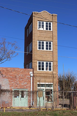
The Newby–McMahon Building, commonly referred to as the World's littlest skyscraper, is located at 511 7th Street in downtown Wichita Falls, Texas. It is a late Neoclassical style red brick and cast stone structure. It stands 40 ft (12 m) tall, and its exterior dimensions are 18 ft (5.5 m) deep and 10 ft (3.0 m) wide. Its interior dimensions are approximately 12 ft (3.7 m) by 9 ft (2.7 m), or approximately 108 sq ft (10.0 m2). Steep, narrow, internal stairways leading to the upper floors occupy roughly 25% of the interior area.
The exposed strata at the surface in and around Wichita Falls are the products of one ancient period of deposition with a modest amount of recent and modern alteration. In all cases, the strata are products of terrigenous (non-marine) environments dominated by fluvial depositional and erosional systems.
Dundee is an unincorporated community located in Archer County, Texas, United States. According to the Handbook of Texas, the community had a population of 12 in 2010. Dundee is located within the Wichita Falls Metropolitan Statistical Area.
Mankins is an unincorporated community located in Archer County, Texas, United States. According to the Handbook of Texas, the community had a population of 10 in 2000. Mankins is located within the Wichita Falls Metropolitan Statistical Area.
The following is a timeline of the history of the city of Wichita Falls, Texas, USA.


