Prairie View, Texas

Last updated • 4 min readFrom Wikipedia, The Free Encyclopedia

Prairie View
Prairie View Texas City Hall 2019.jpg
Prairie View City Hall
Waller County PrairieView.svg
Location of Prairie View, Texas
Coordinates: 30°4′56″N95°59′30″W / 30.08222°N 95.99167°W / 30.08222; -95.99167
Country United States
State Texas
County Waller
Government
  Type Council-Manager
  MayorRonald Leverett [1]
Area
[2]
  Total7.35 sq mi (19.03 km2)
  Land7.35 sq mi (19.03 km2)
  Water0.00 sq mi (0.00 km2)
Elevation
269 ft (82 m)
Population
 (2020)
  Total8,184
  Density946.24/sq mi (365.34/km2)
Time zone UTC-6 (Central (CST))
  Summer (DST) UTC-5 (CDT)
ZIP code
77446
Area code 936
FIPS code 48-59336 [3]
GNIS feature ID1344521 [4]
Website www.prairieviewtexas.gov

Prairie View is a city in Waller County, Texas, United States, situated on the northwestern edge of the Houston–The Woodlands–Sugar Land metropolitan area. The population was 8,184 at the 2020 census.

Contents

Prairie View A&M University, the second-oldest public university in Texas, is based in the city.

Geography

Prairie View is located at 30°4′56″N95°59′30″W / 30.08222°N 95.99167°W / 30.08222; -95.99167 (30.082131, –95.991788). [5]

According to the United States Census Bureau, the city has a total area of 7.2 square miles (18.7 km2), all land. The city is bisected by US 290 and is neighbored by Hempstead to the west, Waller to the east, and Pine Island to the south.

Demographics

Historical population
CensusPop.Note
1960 2,326
1970 3,79663.2%
1980 3,9935.2%
1990 4,0040.3%
2000 4,41010.1%
2010 5,57626.4%
2020 8,18446.8%
U.S. Decennial Census [6]
Prairie View racial composition as of 2020 [7]
(NH = Non-Hispanic) [lower-alpha 1]
RaceNumberPercentage
White (NH)1842.25%
Black or African American (NH)6,71282.01%
Native American or Alaska Native (NH)310.38%
Asian (NH)170.21%
Pacific Islander (NH)10.01%
Some Other Race (NH)1181.44%
Mixed/Multi-Racial (NH)510.62%
Hispanic or Latino 1,07013.07%
Total8,184

As of the 2020 United States census, there were 8,184 people, 1,031 households, and 353 families residing in the city.

As of the census [3] of 2000, there were 4,410 people, 694 households, and 360 families residing in the city. The population density was 611.0 inhabitants per square mile (235.9/km2). There were 834 housing units at an average density of 115.6 per square mile (44.6/km2). The racial makeup of the city was 3.47% White, 93.51% African American, 0.18% Native American, 0.43% Asian, 1.36% from other races, and 1.04% from two or more races. Hispanic or Latino of any race were 2.65% of the population.

There were 694 households, out of which 21.3% had children under the age of 18 living with them, 32.1% were married couples living together, 15.4% had a female householder with no husband present, and 48.0% were non-families. 32.3% of all households were made up of individuals, and 13.1% had someone living alone who was 65 years of age or older. The average household size was 2.42 and the average family size was 3.21.

In the city, the population was spread out, with 9.1% under the age of 18, 68.2% from 18 to 24, 10.3% from 25 to 44, 6.5% from 45 to 64, and 5.9% who were 65 years of age or older. The median age was 21 years. For every 100 females, there were 88.4 males. For every 100 females age 18 and over, there were 87.9 males.

The median income for a household in the city was $24,805, and the median income for a family was $36,071. Males had a median income of $25,882 versus $21,161 for females. The per capita income for the city was $8,219. About 13.2% of families and 24.4% of the population were below the poverty line, including 18.2% of those under age 18 and 14.9% of those age 65 or over.

Government and infrastructure

The City of Prairie View was established in 1969 with the motto: "Productive, United, Indomitable." The city is operated by a mayor-council government of the strong-mayor format. The format functions with the Mayor serving as both Chair of the City Council and Chief Executive of the city's administration.

At present the city's mayor is David Allen. [1] The city practices zoning to control land use and improve quality of life. The city has hired Butler Planning Services (BPS) to develop a Geographic Information System (GIS) which will aid the city staff in mapping the community. The city is also considering a partnership with BPS and another planning firm, IPS Group, to develop a new Comprehensive Plan.

County, state, and federal representation

The United States Postal Service Prairie View Post Office is located at 21212 Farm to Market Road 1098 Loop. [10]

Education

Colleges and universities

Evans Hall at Prairie View A&M University Annie Laurie Evans Hall.JPG
Evans Hall at Prairie View A&M University

Prairie View is home to Prairie View A&M University. The university was established in 1876 as a historically black college under the Morill Land-Grant Acts, making it the first public institution of higher learning in Texas to educate African-Americans. Prairie View A&M grants both graduate and undergraduate degrees in more than 50 majors and is classified as a Doctoral/Research University by the Carnegie Foundation. As of fall 2022, Prairie View A&M is the largest HBCU in the state and one of the largest in the country with nearly 9,500 students, approximately 83% Black/African-American. [11]

Blinn College is the designated community college for residents of the Waller Independent School District. [12] Blinn operates the Waller-Harris County Campus. [13]

Primary and secondary schools

The City of Prairie View is served by the Waller Independent School District. [14]

Schools serving Prairie View include:

Transportation

Greyhound Bus Lines serves the Prairie View Station at Unco Food Store. [17]

Parks and recreation

In September 2018 a cricket complex in Prairie View was scheduled to open. It was established by Pakistani American Tanweer Ahmed. [18]

Sister cities

Prairie View's sister cities are: [19]

Related Research Articles

<span class="mw-page-title-main">Washington County, Texas</span> County in Texas, United States

Washington County is a county in Texas. As of the 2020 census, the population was 35,805. Its county seat is Brenham, which is located along U.S. Highway 290, 72 miles northwest of Houston. The county was created in 1835 as a municipality of Mexico and organized as a county in 1837. It is named for George Washington, the first president of the United States.

<span class="mw-page-title-main">Waller County, Texas</span> County in Texas, United States

Waller County is a county in the U.S. state of Texas. As of the 2020 census, its population was 56,794. Its county seat is Hempstead. The county was named for Edwin Waller, a signer of the Texas Declaration of Independence and first mayor of Austin.

<span class="mw-page-title-main">Robertson County, Texas</span> County in Texas, United States

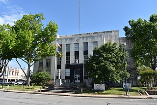
Robertson County is a county in the U.S. state of Texas. As of the 2020 census, its population was 16,757. Its county seat is Franklin. The county was created in 1837 and organized the following year. It is named for Sterling C. Robertson, an early settler who signed the Texas Declaration of Independence.

<span class="mw-page-title-main">Milam County, Texas</span> County in Texas, United States

Milam County is a county located in the U.S. state of Texas. As of the 2020 census, its population was 24,754. The county seat is Cameron. The county was created in 1834 as a municipality in Mexico and organized as a county in 1837. Milam County is named for Benjamin Rush Milam, an early settler and a soldier in the Texas Revolution.

<span class="mw-page-title-main">Madison County, Texas</span> County in Texas, United States

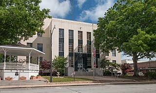
Madison County is a county located in the U.S. state of Texas. As of the 2020 census, its population was 13,455. Its seat is Madisonville. The county was created in 1853 and organized the next year. It is named for James Madison, the fourth President of the United States. In 1852, Hillary Mercer Crabb was elected to serve the unexpired term of State Representative F. L. Hatch. Among Crabb's accomplishments as a legislator was the introduction of a bill to create Madison County.

<span class="mw-page-title-main">Fayette County, Texas</span> County in Texas, United States

Fayette County is a county located in the U.S. state of Texas. As of the 2020 census, the population was 24,435. Its county seat is La Grange. The county was created in 1837 and organized the next year.

<span class="mw-page-title-main">Cooke County, Texas</span> County in Texas, United States

Cooke County is a county in the U.S. state of Texas. At the 2020 census, its population was 41,668. The county seat is Gainesville. The county was founded in 1848 and organized the next year. It is named for William Gordon Cooke, a soldier during the Texas Revolution. It is a part of the Texoma region.

<span class="mw-page-title-main">Burleson County, Texas</span> County in Texas, United States

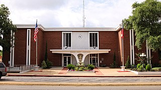
Burleson County is a county located in the U.S. state of Texas. As of the 2020 census, the population was 17,642. Its county seat is Caldwell. The county is named for Edward Burleson, a general and statesman of the Texas Revolution.

<span class="mw-page-title-main">Brazos County, Texas</span> County in Texas, United States

Brazos County is a county in the U.S. state of Texas. As of the 2020 census, its population was 233,849. The county seat is Bryan. Along with Brazoria County, the county is named for the Brazos River, which forms its western border. The county was formed in 1841 and organized in 1843.

<span class="mw-page-title-main">Austin County, Texas</span> County in Texas, United States

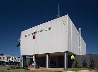
Austin County is a rural, agricultural dominated county in the U.S. state of Texas. As of the 2020 census, the population was 30,167. Its seat is Bellville. The county and region was settled primarily by German emigrants in the 1800s.

<span class="mw-page-title-main">Prairie View, Kansas</span> City in Phillips County, Kansas

Prairie View is a city in Phillips County, Kansas, United States. As of the 2020 census, the population of the city was 106.

<span class="mw-page-title-main">Magnolia, Texas</span> City in Texas, United States

Magnolia is a city in southwestern Montgomery County, Texas, United States within the Houston metropolitan area. It is named for the magnolia trees that grow in the area. The population was 2,359 at the 2020 United States Census.

<span class="mw-page-title-main">Panorama Village, Texas</span> City in Texas, United States

Panorama Village is a city in Montgomery County, Texas, United States.

<span class="mw-page-title-main">Franklin, Texas</span> City in Texas, United States

Franklin is a city in, and the county seat of, Robertson County, Texas, United States. It is within the Brazos Valley, on the cusp of the East and Central Texas regions. As of the 2020 census, the city population was 1,614. The original name of the town was Morgan and it was made county seat in 1879.

<span class="mw-page-title-main">Woodville, Texas</span> Town in and county seat of Tyler County, Texas, United States

Woodville is a town in and the county seat of Tyler County, Texas, United States. The town is intersected by three U.S. Numbered Highways: U.S. Route 69, U.S. Route 190, and U.S. Route 287. The population was 2,403 at the 2020 census. It is the county seat of Tyler County. The town was named after George Tyler Wood, governor of Texas from 1847 to 1849.

<span class="mw-page-title-main">Brookshire, Texas</span> City in Texas, United States

Brookshire is a city in Waller County, Texas, United States, with a population of 5,066 as of the 2020 census.

<span class="mw-page-title-main">Pattison, Texas</span> City in Texas, United States

Pattison is a city in Waller County, Texas, United States. As of the 2020 census, the population was 547.

<span class="mw-page-title-main">Pine Island, Texas</span> Town in Texas, United States

Pine Island is a town in Waller County, Texas, United States near the intersection of Farm to Market Road 359 and Farm to Market Road 3346. The population was 1,077 at the 2020 census. It is not affiliated with the uninhabited island of the same name in Lake Livingston.

<span class="mw-page-title-main">Brenham, Texas</span> City in Texas, United States

Brenham is a city in east-central Texas, United States, and the county seat of Washington County, with a population of 17,369 according to the 2020 U.S. census.

<span class="mw-page-title-main">Waller, Texas</span> City in Harris and Waller counties in Texas, United States

Waller is a city in Harris and Waller counties in Texas, United States, that is within the Houston–Cypress metropolitan area. Its population was 2,682 at the 2020 U.S. census. The Waller area is located along U.S. Route 290 41 miles (66 km) northwest of downtown Houston.

References

  1. 1 2 "Dr. Brian e. Rowland - Mayor".
  2. "2019 U.S. Gazetteer Files". United States Census Bureau. Retrieved August 7, 2020.
  3. 1 2 "U.S. Census website". United States Census Bureau . Retrieved January 31, 2008.
  4. "US Board on Geographic Names". United States Geological Survey. October 25, 2007. Retrieved January 31, 2008.
  5. "US Gazetteer files: 2010, 2000, and 1990". United States Census Bureau. February 12, 2011. Retrieved April 23, 2011.
  6. "Census of Population and Housing". Census.gov. Retrieved June 4, 2015.
  7. "Explore Census Data". data.census.gov. Retrieved May 23, 2022.
  8. https://www.census.gov/ [ not specific enough to verify ]
  9. "About the Hispanic Population and its Origin". www.census.gov. Retrieved May 18, 2022.
  10. "Post Office Location - PRAIRIE VIEW." United States Postal Service . Retrieved on December 6, 2008.
  11. "Are there any HBCUs in Texas? 8 Things About HBCU in Texas - AnanUniversity". October 5, 2022.
  12. Texas Education Code, Sec. 130.168. BLINN JUNIOR COLLEGE DISTRICT SERVICE AREA..
  13. "Waller-Harris County". Blinn College . Retrieved September 10, 2024.
  14. "2020 CENSUS - SCHOOL DISTRICT REFERENCE MAP: Waller County, TX" (PDF). U.S. Census Bureau . Retrieved September 9, 2024. - Text list
  15. "Junior High Schools Attendance Zone Map" (PDF). Waller Independent School District . Retrieved September 10, 2024.
  16. "2024-2025 Elementary School Attendance Zones Map (Detail View)" (PDF). Waller Independent School District . Retrieved September 10, 2024.
  17. "Prairie View, Texas." Greyhound Lines . Retrieved on December 6, 2008.
  18. Collette, Mark (July 18, 2018). "Major cricket complex in Prairie View is Houston man's field of dreams". Houston Chronicle . Retrieved December 28, 2019.
  19. "Sister Cities". City of Prairie View. Retrieved December 21, 2020.
  1. Note: the US Census treats Hispanic/Latino as an ethnic category. This table excludes Latinos from the racial categories and assigns them to a separate category. Hispanics/Latinos can be of any race. [8] [9]