Pine Island, Texas

Last updated

Pine Island, Texas
TXMap-doton-PineIsland.PNG
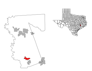
Location of Pine Island, Texas
Waller County PineIsland.svg
Coordinates: 30°3′48″N96°1′23″W / 30.06333°N 96.02306°W / 30.06333; -96.02306
Country United States
State Texas
County Waller
Area
[1]
  Total9.36 sq mi (24.24 km2)
  Land9.34 sq mi (24.20 km2)
  Water0.01 sq mi (0.04 km2)
Elevation
197 ft (60 m)
Population
 (2010)
  Total988
  Estimate 
(2019) [2]
1,159
  Density124.04/sq mi (47.89/km2)
Time zone UTC-6 (Central (CST))
  Summer (DST) UTC-5 (CDT)
ZIP code
77445
Area code 979
FIPS code 48-57615 [3]
GNIS feature ID1388558 [4]

Pine Island is a town in Waller County, Texas, United States near the intersection of Farm to Market Road 359 and Farm to Market Road 3346. The population was 988 at the 2010 census. [5] It is not affiliated with the uninhabited island of the same name in Lake Livingston.

Contents

Geography

Pine Island is located at 30°3′48″N96°1′23″W / 30.06333°N 96.02306°W / 30.06333; -96.02306 (30.063433, –96.022968). [6] According to the United States Census Bureau, the town has a total area of 9.3 square miles (24.2 km2), of which 9.3 square miles (24.2 km2) is land and 0.11% is water.

The western boundary of the town is formed by Clear Creek, which flows from north to south. U.S. Route 290 Business on either side of FM 359 is part of the northern town limit. Cochran Road from north of Brumlow Road south to Betka Road forms the eastern boundary. The southern boundary is formed by Betka Road and an irregular line running west to Clear Creek. [7]

Demographics

Historical population
CensusPop.Note
1990 571
2000 84948.7%
2010 98816.4%
2019 (est.)1,159 [2] 17.3%
U.S. Decennial Census [8]

As of the census [3] of 2000, there were 849 people, 295 households, and 225 families residing in the town. The population density was 91.0 inhabitants per square mile (35.1/km2). There were 333 housing units at an average density of 35.7 per square mile (13.8/km2). The racial makeup of the town was 73.14% White, 12.13% African American, 0.82% Native American, 0.59% Asian, 10.48% from other races, and 2.83% from two or more races. Hispanic or Latino of any race were 22.03% of the population.

There were 295 households, out of which 36.6% had children under the age of 18 living with them, 62.0% were married couples living together, 11.2% had a female householder with no husband present, and 23.4% were non-families. 15.6% of all households were made up of individuals, and 6.4% had someone living alone who was 65 years of age or older. The average household size was 2.88 and the average family size was 3.21.

In the town, the population was spread out, with 28.5% under the age of 18, 9.2% from 18 to 24, 28.0% from 25 to 44, 23.2% from 45 to 64, and 11.1% who were 65 years of age or older. The median age was 34 years. For every 100 females, there were 108.1 males. For every 100 females age 18 and over, there were 102.3 males.

The median income for a household in the town was $45,000, and the median income for a family was $50,714. Males had a median income of $34,167 versus $31,250 for females. The per capita income for the town was $18,597. About 4.7% of families and 7.2% of the population were below the poverty line, including 7.8% of those under age 18 and 4.8% of those age 65 or over.

Education

The Town of Pine Island is served by the Waller Independent School District.

Related Research Articles

<span class="mw-page-title-main">Pine Hill, Alabama</span> Town in Alabama, United States

Pine Hill is a town in Wilcox County, Alabama, United States. It incorporated in 1895. Per the 2020 census, the population was 758.

<span class="mw-page-title-main">Pine Lakes, Florida</span> Census-designated place in Florida

Pine Lakes is an unincorporated community and census-designated place (CDP) in Lake County, Florida, United States. The population was 862 at the 2010 census, up from 755 at the 2000 census. It is part of the Orlando–Kissimmee Metropolitan Statistical Area.

<span class="mw-page-title-main">Bokeelia, Florida</span> Census-designated place in Florida, United States

Bokeelia is an unincorporated community and census-designated place (CDP) located on Pine Island in Lee County, Florida, United States. As of the 2020 census, the CDP had a population of 1,855, up from 1,780 at the 2010 census. It is part of the Cape Coral-Fort Myers, Florida Metropolitan Statistical Area. Bokeelia is still home to one of Lee County's first pioneer families, the Padillas, who came by way of Cayo Costa.

<span class="mw-page-title-main">Matlacha, Florida</span> Census-designated place in Florida, United States

Matlacha is a census-designated place (CDP) in Lee County, Florida, United States. As of the 2020 census, the CDP had a population of 598. It is part of the Cape Coral-Fort Myers, Florida Metropolitan Statistical Area.

<span class="mw-page-title-main">Matlacha Isles-Matlacha Shores, Florida</span> Census-designated place in Florida, United States

Matlacha Isles-Matlacha Shores is an unincorporated community and census-designated place (CDP) in Lee County, Florida, United States. The population was 227 at the 2020 census, down from 229 at the 2010 census. It is part of the Cape Coral-Fort Myers, Florida Metropolitan Statistical Area.

<span class="mw-page-title-main">Pine Island Center, Florida</span> Census-designated place in Florida, United States

Pine Island Center is an unincorporated community and census-designated place (CDP) located on Pine Island in Lee County, Florida, United States. The population was 1,942 at the 2020 census. It is part of the Cape Coral-Fort Myers, Florida Metropolitan Statistical Area.

<span class="mw-page-title-main">St. James City, Florida</span> Census-designated place in Florida, United States

St. James City is an unincorporated community and census-designated place (CDP) on Pine Island in Lee County, Florida, United States. The population was 3,876 at the 2020 census, up from 3,784 at the 2010 census. It is part of the Cape Coral-Fort Myers, Florida Metropolitan Statistical Area.

<span class="mw-page-title-main">Town of Pines, Indiana</span> Town in Indiana, United States

Town of Pines is a town in Pine Township, Porter County, in the U.S. state of Indiana. The population was 708 at the 2010 census.

<span class="mw-page-title-main">Pine River, Minnesota</span> City in Minnesota, United States

Pine River is a city in Cass County, Minnesota, United States. The population was 911 at the 2020 census. It is part of the Brainerd Micropolitan Statistical Area.

<span class="mw-page-title-main">Rutledge, Minnesota</span> City in Minnesota, United States

Rutledge is a city in Pine County, Minnesota, United States, at the confluence of the Kettle and Pine Rivers. The population was 229 at the 2010 census.

<span class="mw-page-title-main">Pine Knoll Shores, North Carolina</span> Town in North Carolina, United States

Pine Knoll Shores is a coastal town in Carteret County, North Carolina, United States. The population was 1,388 at the 2020 census. One of North Carolina's state aquariums is located here.

<span class="mw-page-title-main">Seven Fields, Pennsylvania</span> Place in Pennsylvania, United States

Seven Fields is a borough in Butler County, Pennsylvania, United States. The population was 2,887 at the 2010 census, an increase from the figure of 1,986 tabulated in 2000.

<span class="mw-page-title-main">West Finley Township, Pennsylvania</span> Township in Pennsylvania, United States

West Finley Township is a township in Washington County, Pennsylvania, United States. The population was 813 at the 2020 census.

<span class="mw-page-title-main">Exeter, Rhode Island</span> Town in Rhode Island, United States

Exeter is a town in Washington County, Rhode Island, United States. Exeter extends east from the Connecticut border to the town of North Kingstown. It is bordered to the north by West Greenwich and East Greenwich, and to the south by Hopkinton, Richmond, and South Kingstown. Exeter's postal code is 02822, although small parts of the town have the mailing address West Kingston (02892) or Saunderstown (02874). The population was 6,460 at the 2020 census.

<span class="mw-page-title-main">Guys, Tennessee</span> Town in Tennessee, United States

Guys is a town in McNairy County, Tennessee. The population was 466 at the 2010 census.

<span class="mw-page-title-main">Arland, Wisconsin</span> Town in Wisconsin, United States

Arland is a town in Barron County in the U.S. state of Wisconsin. The population was 789 at the 2010 census. The unincorporated community of Twin Town is located partially in the town.

<span class="mw-page-title-main">Pine Haven, Wyoming</span> Town in Wyoming, United States

Pine Haven is a town in Crook County, Wyoming, United States. The population was 493 at the 2020 census.

<span class="mw-page-title-main">Pine Island, Minnesota</span> City in Minnesota, United States

Pine Island is a city in Goodhue and Olmsted counties in the U.S. state of Minnesota. Most of Pine Island is in Goodhue County, but a small part extends into Olmsted County, making that portion part of the Rochester metropolitan area. As of the 2020 census, the population was 3,769.

<span class="mw-page-title-main">Seven Springs, Pennsylvania</span> Borough in Pennsylvania, United States

Seven Springs is a borough in Somerset and Fayette counties in the U.S. state of Pennsylvania. The Fayette County portion of the borough and resort are part of the Pittsburgh metropolitan area, and the Somerset County portion is part of the Johnstown Metropolitan Area. The population of the borough was 26 as of the 2010 census, compared to 127 at the 2000 census. Fifteen of the residents in 2010 were in Fayette County, and 11 in Somerset County.

<span class="mw-page-title-main">Pine Plains (CDP), New York</span> Census-designated place in New York, United States

Pine Plains is a hamlet and census-designated place (CDP) in Dutchess County, New York, United States. The population was 1,142 at the 2020 census. It is part of the Poughkeepsie–Newburgh–Middletown, NY Metropolitan Statistical Area as well as the larger New York–Newark–Bridgeport, NY-NJ-CT-PA Combined Statistical Area.

References

  1. "2019 U.S. Gazetteer Files". United States Census Bureau. Retrieved August 7, 2020.
  2. 1 2 "Population and Housing Unit Estimates". United States Census Bureau. May 24, 2020. Retrieved May 27, 2020.
  3. 1 2 "U.S. Census website". United States Census Bureau . Retrieved January 31, 2008.
  4. "US Board on Geographic Names". United States Geological Survey. October 25, 2007. Retrieved January 31, 2008.
  5. "Population and Housing Unit Counts, 2010 Census of Population and Housing" (PDF). Texas: 2010. Retrieved January 2, 2017.
  6. "US Gazetteer files: 2010, 2000, and 1990". United States Census Bureau. February 12, 2011. Retrieved April 23, 2011.
  7. Google (February 17, 2013). "Pine Island, Texas" (Map). Google Maps . Google. Retrieved February 17, 2013.
  8. "Census of Population and Housing". Census.gov. Retrieved June 4, 2015.