Chester, Texas

Last updated

Chester, Texas
TXMap-doton-Chester.PNG
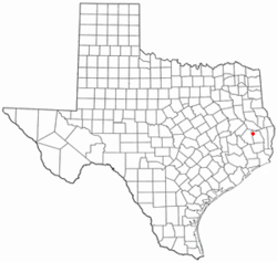
Location of Chester, Texas
Tyler County Chester.svg
Coordinates: 30°55′24″N94°35′57″W / 30.92333°N 94.59917°W / 30.92333; -94.59917
Country United States
State Texas
County Tyler
Area
[1]
  Total1.57 sq mi (4.08 km2)
  Land1.57 sq mi (4.08 km2)
  Water0.00 sq mi (0.00 km2)
Elevation
[2]
246 ft (75 m)
Population
 (2010)
  Total312
  Estimate 
(2019) [3]
311
  Density197.46/sq mi (76.25/km2)
Time zone UTC-6 (Central (CST))
  Summer (DST) UTC-5 (CDT)
ZIP code
75936
Area code 936
FIPS code 48-14584 [4]
GNIS feature ID1354374 [2]

Chester is a town in Tyler County, Texas, United States. The population was 312 at the 2010 census.

Contents

Geography

Chester is located at 30°55′24″N94°35′57″W / 30.92333°N 94.59917°W / 30.92333; -94.59917 (30.923401, –94.599131). [5]

According to the United States Census Bureau, the town has a total area of 1.6 square miles (4.1 km2), all of it land.

History

Chester, located in the northwest corner of the county, was named after President Chester A. Arthur. It formed in 1883 when the Trinity and Sabine Railway, which connected Colmesneil in the east to Trinity in the west, routed its new line just a few miles south and west of the earlier community of Peach Tree Village. The community moved the post office, Mount Hope Masonic Lodge, and several businesses to the area alongside the track. A. B. Green, postmaster of Peach Tree Village, became the first postmaster of the new postoffice named Chester. The town of Chester incorporated in 1968. [6] [7]

Demographics

Historical population
CensusPop.Note
1970 260
1980 30517.3%
1990 285−6.6%
2000 265−7.0%
2010 31217.7%
2019 (est.)311 [3] −0.3%
U.S. Decennial Census [8]

As of the census [4] of 2000, 265 people, 101 households, and 75 families resided in the town. The population density was 166.1 inhabitants per square mile (64.1/km2). The 128 housing units averaged 80.2 per square mile (30.9/km2). The racial makeup of the town was 97.74% White, 0.38% Asian, 1.13% from other races, and 0.75% from two or more races. Hispanics or Latino of any race were 3.40% of the population.

Of the 101 households, 32.7% had children under the age of 18 living with them, 63.4% were married couples living together, 6.9% had a female householder with no husband present, and 25.7% were not families. About 20.8% of all households were made up of individuals, and 10.9% had someone living alone who was 65 years of age or older. The average household size was 2.62 and the average family size was 3.08.

In the town, the population was distributed as 23.0% under the age of 18, 12.1% from 18 to 24, 29.8% from 25 to 44, 21.5% from 45 to 64, and 13.6% who were 65 years of age or older. The median age was 33 years. For every 100 females, there were 89.3 males. For every 100 females age 18 and over, there were 85.5 males.

The median income for a household in the town was $40,313, and for a family was $46,875. Males had a median income of $30,536 versus $14,750 for females. The per capita income for the town was $14,659. About 3.8% of families and 5.8% of the population were below the poverty line, including 3.0% of those under the age of 18 and 7.9% of those 65 or over.

Education

The Town of Chester is served by the Chester Independent School District.

Related Research Articles

<span class="mw-page-title-main">Tyler County, Texas</span> County in Texas, United States

Tyler County is a county located in the U.S. state of Texas. It is in East Texas and its seat is Woodville.

<span class="mw-page-title-main">Delhi, Minnesota</span> City in Minnesota, United States

Delhi is a city in Redwood County, Minnesota, United States. The population was 70 at the 2010 census. The city is also home to the legendary Delhi Man.

<span class="mw-page-title-main">Muddy, Montana</span> Census-designated place in Montana, United States

Muddy or Heóvonėheo'hé'e is a census-designated place (CDP) in Big Horn County, Montana, United States and home to the Heóvonėheo'hé'etaneo'o or Heóvonêheo'he'é-taneno Cheyenne people. The population was 617 at the 2010 census.

<span class="mw-page-title-main">Melstone, Montana</span> Town in Montana, United States

Melstone is a rural small town in far eastern Musselshell County, Montana, United States, along U.S. Route 12. The population was 126 at the 2020 census. The town was established in 1908 as a base for operating crews on the Chicago, Milwaukee, St. Paul and Pacific Railroad, then under construction in Montana. Although the railroad was abandoned in 1980, Melstone survives as a community center for farmers and ranchers in the lower Musselshell River valley. It has a K-12 school with a staff of 16, which in the Fall of 2017 successfully began a 4-day school week.

<span class="mw-page-title-main">Avon, Montana</span> CDP in Montana, United States

Avon is a census-designated place (CDP) in Powell County, Montana, United States. The population was 124 at the 2000 census. The town sits along the Little Blackfoot River, and serves as a gateway to the Beaverhead-Deerlodge National Forest.

<span class="mw-page-title-main">Walton Park, New York</span> CDP in New York, United States

Walton Park is a census-designated place (CDP) in Orange County, New York, United States. As of the 2020 census, the CDP had a total population of 3,907. Walton Park is on the town line separating the towns of Chester and Monroe. Street addresses within Walton Park are usually assigned to Monroe, not Chester.

<span class="mw-page-title-main">Highland, Ohio</span> Village in Ohio, United States

Highland is a village in Fairfield Township, Highland County, Ohio, United States. The population was 232 at the 2020 census.

<span class="mw-page-title-main">Clinton, Ohio</span> Village in Ohio, United States

Clinton is a village in southwestern Summit County, Ohio, United States. The population was 1,197 at the 2020 Census. It is part of the Akron metropolitan area.

<span class="mw-page-title-main">St. Stephen, South Carolina</span> Town in South Carolina, United States

St. Stephen is a town in Berkeley County, South Carolina, United States. The population was 1,697 at the 2010 census.

<span class="mw-page-title-main">Great Falls, South Carolina</span> Town in South Carolina, United States

Great Falls is a town in Chester County, South Carolina, United States and is located fourteen miles southwest of Lancaster, South Carolina. The population was 1,951 at the 2020 census.

<span class="mw-page-title-main">Burke, Texas</span> City in Texas, United States

Burke is a city in southwestern Angelina County, Texas, United States. The population was 737 at the 2010 census.

<span class="mw-page-title-main">Paint Rock, Texas</span> Town in Texas, United States

Paint Rock is a town in and the county seat of Concho County, Texas, United States. The population was 273 at the 2010 census, down from 320 at the 2000 census.

<span class="mw-page-title-main">Nordheim, Texas</span> City in Texas, United States

Nordheim is a city in DeWitt County, Texas, United States. The population was 336 at the 2020 census.

<span class="mw-page-title-main">Kenefick, Texas</span> Town in Texas, United States

Kenefick is a town in Liberty County, Texas, United States. The population was 563 at the 2010 census.

<span class="mw-page-title-main">Mount Enterprise, Texas</span> City in Texas, United States

Mount Enterprise is a city in Rusk County, Texas, United States. The population was 447 at the 2010 census.

<span class="mw-page-title-main">Shepherd, Texas</span> City in Texas, United States

Shepherd is a city in San Jacinto County, Texas, United States. The population was 2,105 at the 2020 census.

<span class="mw-page-title-main">Woodville, Texas</span> Town in Texas, United States

Woodville is a town in Tyler County, Texas, United States. The town is intersected by three U.S. highways: U.S. Highway 69, U.S. Highway 190, and U.S. Highway 287. The population was 2,403 at the 2020 census. It is the county seat of Tyler County. The town was named after George Tyler Wood, governor of Texas from 1847 to 1849.

<span class="mw-page-title-main">Burton, Texas</span> City in Texas, United States

Burton is a city in Washington County, Texas, United States. The population was 359 at the 2000 census. Prior to the 2010 census, Burton changed its status from a town to a city. The population was 300 at the 2010 census.

<span class="mw-page-title-main">Matewan, West Virginia</span> Town in West Virginia, United States

Matewan is a town in Mingo County, West Virginia, United States at the confluence of the Tug Fork River and Mate Creek. The population was 499 at the 2010 census. The Norfolk Southern Railway's Pocahontas District passes through the town. It was a key site of the Coal Wars and the location of the Battle of Matewan in 1920.

<span class="mw-page-title-main">Tower City, North Dakota</span> City in North Dakota, United States

Tower City is a city in Barnes and Cass counties in the State of North Dakota. The population was 268 at the 2020 census.

References

  1. "2019 U.S. Gazetteer Files". United States Census Bureau. Retrieved August 7, 2020.
  2. 1 2 U.S. Geological Survey Geographic Names Information System: Chester, Texas
  3. 1 2 "Population and Housing Unit Estimates". United States Census Bureau. May 24, 2020. Retrieved May 27, 2020.
  4. 1 2 "U.S. Census website". United States Census Bureau . Retrieved January 31, 2008.
  5. "US Gazetteer files: 2010, 2000, and 1990". United States Census Bureau. February 12, 2011. Retrieved April 23, 2011.
  6. Biesele, Megan. "Chester, TX". Handbook of Texas. Texas State Historical Association. Retrieved July 1, 2021.
  7. "Chester, Texas". TexasEscapes. Retrieved July 1, 2021.
  8. "Census of Population and Housing". Census.gov. Retrieved June 4, 2015.