Chappell Hill, Texas

Last updated

Chappell Hill, Texas
ChappellHillMainStreet10.JPG
Image-TXMap-doton-ChappellHill.png
Location of Chappell Hill, Texas
Coordinates: 30°08′34″N96°15′25″W / 30.14278°N 96.25694°W / 30.14278; -96.25694
Country United States
State Texas
County Washington
Area
  Water0.0 sq mi (0.0 km2)
Elevation
[1]
299 ft (91 m)
Population
 (2000)
  Total600
Time zone UTC-6 (Central (CST))
  Summer (DST) UTC-5 (CDT)
ZIP code
77426
Area code 979
GNIS feature ID1332674 [1]

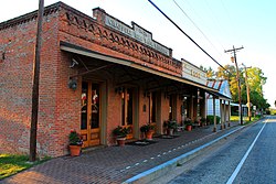
Chappell Hill is an unincorporated community in the eastern portion of Washington County, Texas, United States. It is located inside Stephen F. Austin's original colony, and the land is some of the oldest Anglo-settled in the state. According to the Handbook of Texas, the community had a population of 600 in 2000. It is located within the Greater Houston metropolitan area.

Contents

Geography

Chappell Hill is located at the junction of US Route 290 and Farm to Market Roads 1155 and 2447. Chappell Hill is located within the Brazos River watershed. The area is part of the Gulf Coastal Plain, and the terrain is rolling hills. The community is located 10 mi (16 km) east of Brenham, 98 mi (158 km) east of Austin, 12 mi (19 km) west of Hempstead, and 63 mi (101 km) northwest of Houston. [2]

History

19th century

The town was established in 1849 by Mary Elizabeth Haller, who founded the town on 100 acres (0.40 km2) of land she bought and having opened a post office two years earlier. She then named the town after her maternal grandfather Robert Wooding Chappell. [3] The area around the town was settled by planters from the Deep South and, thanks to the fertile soil of the Brazos River valley, cotton became the area's main crop.

Jacob Haller and Mary built in 1850 a large home that served as a boarding house and then became the Stage Coach Inn, which Mary or her mother Charlotte Hargrove operated until 1859, continuing under new ownership until 1871. Because the inn was about halfway between Houston and Austin, it was a convenient stopover for travelers along the two major stagecoach lines.

Before the Civil War, the population reached a maximum of about 3,000 people; at that time, San Antonio and Galveston were the largest towns at around 8,000 people. A sawmill, a railroad line, five churches, and a Masonic Lodge were built in the area. [4]

The town was incorporated in 1856. [3]

The men of Chappell Hill formed part of the First Texas Lancers cavalry regiment during the Civil War and fought in Missouri, Louisiana, and Arkansas. Men from Chappell Hill served in numerous renowned Confederate units, including the Texas Brigade and Terry's Texas Rangers, and saw action in most of the major engagements of the Civil War. In addition, the Soule University building was used as a field hospital.

In 1867, a yellow fever epidemic decimated the town and other southeast Texas towns. Many men who survived combat lost their lives just two years after the war's end. The town never recovered and faded into obscurity. Polish immigrants, mostly from the German partition, began to appear in the 1870s, and the area was re-settled, though it did not reach the status[?] of before. In 1889, Father Grabinger from Brenham's St. Mary's established St. Stanislaus Roman Catholic Church. Denizens of Polish ancestry can still be found in the area surrounding the church and throughout Washington and Austin counties.

20th and 21st centuries

In 1933, the Farmers Bank of Chappell Hill refused to close its doors when President Franklin Delano Roosevelt ordered a March 6 to March 10 banking freeze. The owner of the bank took out an ad in a Boston newspaper protesting the order.

Chappell Hill today has a tourist economy, attracting visitors with its restored homes, the Bluebonnet Festival, its own sausage company, its Independence Day parade, a Scarecrow Festival, and a museum Archived December 14, 2007, at the Wayback Machine . The Main Street Historic District is listed on the National Register of Historic Places. Chappell Hill remains one of the best historically preserved towns in Texas. In 1997, the Texas Legislature designated the Chappell Hill Bluebonnet Festival as the official "Bluebonnet Festival of Texas". [5]

On May 10, 2008, an election was held to incorporate Chappell Hill into its own town government. 201 ballots were cast out of a possible 297 eligible voters. Incorporation was rejected by almost 3 to 1 voters: 148 votes against and just 53 for. 90 votes were cast in the mayoral poll; Julie Edwards received 55 votes and Mary Tom Middlebrooks won 35. For the two unopposed council positions, Travis Bevers received 62 votes while Larry C. Wiese received 60. The results of these contests were immediately invalidated by the anti-incorporation outcome.

The Brenham Banner-Press occasionally covers the news in Chappell Hill. [6]

Buildings on the National Register of Historic Places

Demographics

As of the 2000 U.S. Census, approximately 600 people were living in the town of Chappell Hill itself. [3]

1,319 people, 532 households, and 377 families live in the Chappell Hill ZIP code area (77426). [7] Of the 1,319 people, 925 are white, 343 are black, and 34 are of another race. Most people are Roman Catholic, Methodist, or Southern Baptist in faith.

Education

Chappell Hill's first school was established in 1850.Today, the community is served by the Brenham Independent School District.[ page needed ]

Notable people

See also

Related Research Articles

<span class="mw-page-title-main">Washington County, Texas</span> County in Texas, United States

Washington County is a county in Texas. As of the 2020 census, the population was 35,805. Its county seat is Brenham, which is located along U.S. Highway 290, 72 miles northwest of Houston. The county was created in 1835 as a municipality of Mexico and organized as a county in 1837. It is named for George Washington, the first president of the United States.

<span class="mw-page-title-main">Austin County, Texas</span> County in Texas, United States

Austin County is a rural, agricultural dominated county in the U.S. state of Texas. As of the 2020 census, the population was 30,167. Its seat is Bellville. The county and region was settled primarily by German emigrants in the 1800s.

<span class="mw-page-title-main">Brenham, Texas</span> City in Texas, United States

Brenham is a city in east-central Texas, United States, and the county seat of Washington County, with a population of 17,369 according to the 2020 U.S. census.

<span class="mw-page-title-main">Washington-on-the-Brazos, Texas</span> Unincorporated community in Texas, United States

Washington-on-the-Brazos is an unincorporated community along the Brazos River in Washington County, Texas, United States. The town is best known for being the site of the Convention of 1836 and the signing of the Texas Declaration of Independence.

<span class="mw-page-title-main">U.S. Route 290</span> Highway in Texas

U.S. Route 290 is an east–west U.S. Highway located entirely within the state of Texas. Its western terminus is at Interstate 10 southeast of Segovia, and its eastern terminus is at Interstate 610 in northwest Houston. It is the main highway between Houston and Austin and is a cutoff for travelers wanting to bypass San Antonio on Interstate 10. Throughout its length west of Austin, US 290 cuts across mountainous hills comprising the Texas Hill Country and the Edwards Plateau; between Austin and Houston, the highway then travels through gradually hilly grasslands and pine forests comprising the Gulf Coastal Plains.

Independence is an unincorporated community in Washington County, Texas, United States. According to the Handbook of Texas, the community had a population of 140 in 2000. It is located about an hour northwest of the Greater Houston metropolitan area.

<span class="mw-page-title-main">Area code 979</span> Area code in Texas, United States

Area code 979 is a telephone area code in the North American Numbering Plan (NANP) for the U.S. state of Texas. The numbering plan area comprises the region generally following the Brazos River found between the Austin and Houston metro areas and its surrounding communities, stretching from just south of Waco to the Gulf Coast. It was created on February 13, 2000, in a split from area code 409.

<span class="mw-page-title-main">History of Austin, Texas</span>

After declaring its independence from Mexico in March, 1836, the Republic of Texas had numerous locations as its seat of government. This being seen as a problem attempts were made to select a permanent site for the capital. January, 1839, with Mirabeau B. Lamar as the newly elected president, a site selection commission of five commissioners was formed. Edward Burleson had surveyed the planned townsite of Waterloo, near the mouth of Shoal Creek on the Colorado River, in 1838; it was incorporated January 1839. By April of that year the site selection commission had selected Waterloo to be the new capital. A bill previously passed by Congress in May, 1838, specified that any site selected as the new capital would be named Austin, after the late Stephen F. Austin; hence Waterloo upon selection as the capital was renamed Austin. The first lots in Austin went on sale August 1839.

<span class="mw-page-title-main">Greater Austin</span> Metropolitan Statistical Area in Texas, United States

The Austin–Round Rock–San Marcos metropolitan statistical area, or Greater Austin, is a five-county metropolitan area in the U.S. state of Texas, as defined by the Office of Management and Budget. The metropolitan area is situated in Central Texas on the western edge of the American South and on the eastern edge of the American Southwest, and borders Greater San Antonio to the south.

Latium, is an unincorporated community in Washington County, Texas, United States. According to the Handbook of Texas, the community had a population of 30 in 2000. It is located within the Greater Houston metropolitan area.

The history of the Jews in Brenham, Texas; covers a period of over 140 years. As one of the first areas in Texas, outside of major population centers, to develop a sizable Jewish population, the community boasts many things of historical note. The Brenham community was formally organized in 1885.

<span class="mw-page-title-main">Downtown Austin</span> Neighborhood in Austin, Texas

Downtown Austin is the central business district of Austin, Texas, United States. The area of the district is bound by Lamar Boulevard to the west, Martin Luther King Jr. Boulevard to the north, Interstate 35 to the east, and Lady Bird Lake to the south.

<span class="mw-page-title-main">Kenney, Texas</span> Unincorporated community in Texas, United States

Kenney is an unincorporated community in northern Austin County, Texas, United States. According to the Handbook of Texas, the community had a population of 200 in 2000. It is located within the Greater Houston metropolitan area.

<span class="mw-page-title-main">Central Texas</span> Geographic region

Central Texas is a region in the U.S. state of Texas roughly bordered on the West by San Saba to the Southeast by Bryan and the South by San Marcos to the North by Hillsboro. Central Texas overlaps with and includes part of the Texas Hill Country and corresponds to a physiographic section designation within the Edwards Plateau, in a geographic context.

<span class="mw-page-title-main">Stagecoach Inn of Chappell Hill</span> United States historic place

The Stagecoach Inn of Chappell Hill is a historic stagecoach inn at Main and Chestnut Streets in Chappell Hill, Texas, United States.

<span class="mw-page-title-main">Robertson's Colony</span>

Robertson's Colony was an empresario colonization effort during the Mexican Texas period. It is named after Sterling C. Robertson, but had previously been known by other names. It has also been referred to as the Nashville Colony, after the Tennessee city where the effort originated, the Texas Association, the Upper Colony, and Leftwich's Grant, named after early colonizer Robert Leftwich. The eventual contract spread over an area that includes all or part of thirty present-day counties in Texas.

<span class="mw-page-title-main">Burleigh, Texas</span> Unincorporated community in Texas, United States

Burleigh is an unincorporated community in northeastern Austin County, in the U.S. state of Texas. According to the Handbook of Texas, its population was 69 from 1972 through 2000. It is located within the Greater Houston metropolitan area.

<span class="mw-page-title-main">Frydek, Texas</span> Unincorporated community in Texas, United States

Frydek is an unincorporated community in southeastern Austin County, Texas, United States. According to the Handbook of Texas, the community had a population of 150 from 1964 through 2000. It is located within the Greater Houston metropolitan area.

Chappell Hill Female College was a private college in Chappell Hill, a rural community in Washington County, Texas, United States. It was founded in 1850 as part of the coeducational school Chappell Hill Male and Female Institute. First chartered by the Texas Legislature in 1852 as a non-denominational preparatory school, the charter was amended to affiliate the school with the Methodist Church in 1854, and was rechartered as a women's college after the male department was spun off as Soule University in 1856. It was closed in 1912 and the building became a public school until a replacement was built in 1927 that preserves the college's bell. The site was added to the National Register of Historic Places in 1985.

Sandy Hill is an unincorporated community in Washington County, Texas, United States. According to the Handbook of Texas, the community had a population of 50 in 2000. It is located within the Greater Houston metropolitan area.

References

  1. 1 2 U.S. Geological Survey Geographic Names Information System: Chappell Hill, Texas
  2. "Chappell Hill, Texas". Texas Escapes Online Magazine. Retrieved June 12, 2023.
  3. 1 2 3 Handbook of Texas Online, Chappell Hill. https://tshaonline.org/handbook/online/articles/hlc21.
  4. Southwestern University Historical Page. http://www.southwestern.edu/library/how-we-remember/root-institutions/Soulerevised.htm Archived September 27, 2007, at the Wayback Machine
  5. Hatch, Rosie (Ed.) (2022). Texas Almanac 2022-2023. Austin, Texas: Texas State Historical Association. p. 21. ISBN   9781625110664.
  6. "Brenham Banner". The Portal to Texas History. Retrieved March 19, 2021.
  7. Census Factfinder, Zipcode 77426. (Link)
  8. Heart of San Antonio
  9. Martin Ruter
  10. "1938 NFL Draft Listing". Pro-Football-Reference.com. Retrieved March 25, 2023.
  11. (September 7, 1888). "Rev Hosea Garrett Obituary, Dallas Morning News, page 2.
  12. Rodney Brown at World Athletics