
Ward County is a county located in the U.S. state of Texas. As of the 2020 census, its population was 11,644. The county seat is Monahans. The county was created in 1887 and organized in 1892. It is named for Thomas W. Ward, a soldier in the Texas Revolution.

Pelham is a city in Shelby County, Alabama, United States. The population was 24,318 at the 2020 census, It incorporated on July 10, 1964 and is a suburb located in the Birmingham metropolitan area, Alabama which was home to nearly 1.2 million residents as of the 2020 census. It was named for Confederate Civil War officer John Pelham.

Progress Village is a census-designated place (CDP) in Hillsborough County, Florida, United States. Per the 2020 census, the population was 11,188.

Goldenrod is a census-designated place (CDP) in Orange and Seminole counties in the U.S. state of Florida. The population was 12,039 at the 2010 census. It is part of the Orlando–Kissimmee–Sanford, Florida Metropolitan Statistical Area.

Belleville is a city in and the county seat of Republic County, Kansas, United States. As of the 2020 census, the population of the city was 2,007.

Alden is a city in Rice County, Kansas, United States. As of the 2020 census, the population of the city was 122.

Argonia is a city in Sumner County, Kansas, United States. As of the 2020 census, the population of the city was 456.
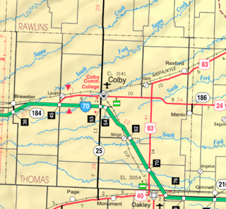
Gem is a city in Thomas County, Kansas, United States. As of the 2020 census, the population of the city was 98.

Rockwood is a city in southeastern Wayne County in the U.S. state of Michigan. The population was 3,289 at the 2010 census.

Northwoods is a city in St. Louis County, Missouri, United States. The population was 4,227 at the 2010 census.

Velda City is a city in St. Louis County, Missouri, United States. The population was 1,420 at the 2010 census.

Oak City, formerly known as Goose Nest, is a town in Martin County, North Carolina, United States. The population was 266 at the 2020 census.

Maddock is a city in Benson County, North Dakota, United States. The population was 402 at the 2020 census. Maddock was founded in 1901.

Urbancrest is a village in Franklin County, Ohio, United States. The population was 1,031 at the 2020 census. Urbancrest is in the South-Western City Schools District.

West Providence Township is a township in Bedford County, Pennsylvania, United States. The population was 3,078 at the 2020 census.
Shippenville is a borough in Clarion County, Pennsylvania, United States. The population was 446 at the 2020 census.

Mifflintown is a borough in and the county seat of Juniata County, Pennsylvania, United States. The population was 842 at the 2020 census.

Pennsburg is a borough in Montgomery County, Pennsylvania. Its population was 3,889 at the 2020 census. It is part of the Upper Perkiomen School District. It is also part of the strip of small towns that run together along Route 29: Red Hill, Pennsburg, and East Greenville. The towns are collectively referred to as Upper Perk.

Pecos is the largest city in and the county seat of Reeves County, Texas, United States. It is in the valley on the west bank of the Pecos River at the eastern edge of the Chihuahuan Desert, in the Trans-Pecos region of West Texas and just south of New Mexico's border. Its population was 12,916 at the 2020 census. On January 24, 2012, Pecos City appeared on the Forbes 400 as the second-fastest growing small town in the United States. The city is a regional commercial center for ranching, oil and gas production, and agriculture. The city is most recognized for its association with the local cultivation of cantaloupes. Pecos claims to be the site of the world's first rodeo on July 4, 1883.

Toyah is a town in Reeves County, Texas, United States. The population was 61 at the 2020 census.


