Adamsville, Texas

Last updated

Adamsville, Texas
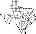
USA Texas location map.svg
Red pog.svg
Adamsville
Coordinates: 31°18′5″N98°10′8″W / 31.30139°N 98.16889°W / 31.30139; -98.16889
Country United States
State Texas
County Lampasas
Elevation
1,063 ft (324 m)
Time zone UTC-6 (Central (CST))
  Summer (DST) UTC-5 (CDT)
Area codes 512 and 737
GNIS feature ID1350883 [1]

Adamsville is an unincorporated community in Lampasas County, Texas, United States. [1] According to the Handbook of Texas, the community had a population of 41 in 2000. It is located within the Killeen-Temple-Fort Hood metropolitan area.

Contents

History

The area in what is known as Adamsville today was established around 1856. Joseph Leland Straley built one of the first houses in the area. Jasper and Perry Townsen also settled here. In the 1870s, the community hosted several cattle drives that were driven short distances to join larger cattle trails to the north. One of the Townsen brothers, Jasper, built a mill on Mill Branch near the intersection of the Lampasas River and Mill Branch, about two miles southeast of Adamsville. The mill originally sent cut lumber from Round Rock, but another mill that was used for wheat and corn was built. Both served the entire county. McCall Smith opened one of the first stores in the community and was also operated by a Presbyterian minister and a man named John Adams. Another store was located near the mills. A post office was established at Adamsville in 1876 in that store and was named Townsen Mills for Perry Townsen, the first postmaster. When people were surveying the land along Simms Creek in the 1870s, several Native American attacks occurred while they were working. A Cumberland Presbyterian church was the first church built in Adamsville in 1881. Perry Townsen died in an accident on New Year's Day, 1891. Jasper then asked for the post office to be relocated and was transferred to the other store in Adamsville. It was named after John Adams, who owned the store during that time. Jasper Townsen then sold the mill, which was transferred to Hamilton County. Several other mills were operating here as well. There were two churches, several stores, a cafe, and a locker plant in Adamsville in 1974. Its population ranged from 75 to 100 from the mid-1880s to the early-1930s. It dropped to 10 in 1933 but rose again in 1941. It went up from 150 to 200 in 1961 but declined again to 28 from 1972 through 1990. Its population rose to 41 in 2000. [2] The population went up to 45 in 2010. [3]

The John Patterson House in the community is on the National Register of Historic Places. [4]

Geography

Adamsville is located at the intersection of U.S. Route 281 and Farm to Market Road 581 on the Lampasas River, 16.5 mi (26.6 km) north of Lampasas in northern Lampasas County. [2]

Climate

The climate in this area is characterized by hot, humid summers and generally mild to cool winters. According to the Köppen Climate Classification system, Adamsville has a humid subtropical climate, abbreviated "Cfa" on climate maps. [5]

Education

Straley's School was the first school built in Adamsville in 1885 and also served as a church for Baptist and Presbyterian congregations. Another school was built in 1918 and burned to the ground on March 27, 1942. A school in nearby Mount View was moved to Adamsville sometime after World War II. [2] Today the community is served by the Lampasas Independent School District, with elementary-age kids going to Hanna Springs Elementary School.

Related Research Articles

<span class="mw-page-title-main">Mills County, Texas</span> County in Texas, United States


Mills County is a county located in Central Texas, United States. It was created on March 15, 1887, from parts of four existing counties—Brown, Comanche, Hamilton, and Lampasas. The 2020 census reported a population of 4,456. The county seat is Goldthwaite.

<span class="mw-page-title-main">Lampasas County, Texas</span> County in Texas, United States

Lampasas County is a county located on the Edwards Plateau in the U.S. state of Texas. As of the 2020 census, its population was 21,627. Its county seat is Lampasas. The county is named for the Lampasas River.

<span class="mw-page-title-main">Brady, Texas</span> City in Texas, United States

Brady is a city in McCulloch County, Texas, United States. Brady refers to itself as the "Heart of Texas", as it is the city closest to the geographical center of the state, which is about 15 miles northeast of Brady. Its population was 5,528 at the 2010 census. It is the county seat of McCulloch County.

Pollok is an unincorporated community in Angelina County, Texas, United States. According to the Handbook of Texas, the community had a population of 300 in 2000. It is located within the Lufkin, Texas micropolitan area.

Bend is an unincorporated community in Lampasas and San Saba counties in western Central Texas. Its population was 1,678 as of the 2010 census.

<span class="mw-page-title-main">Huckabay, Texas</span> Unincorporated community in Texas, United States

Huckabay is an unincorporated community located at the intersection of State Highway 108 and Farm to Market Road 219, ten miles northwest of Stephenville in Erath County, Texas, United States. It had a population of approximately 150 in 2000.

Forestburg is an unincorporated community in Montague County, Texas, United States. According to the Handbook of Texas, the community had a population of 50 in 2000.

Medina is an unincorporated community in Bandera County, Texas, United States. It is part of the San Antonio Metropolitan Statistical Area. Medina is famous for its apples. The community's population was estimated to be 515 in 2000.

<span class="mw-page-title-main">Maydelle, Texas</span> Unincorporated community in Texas, United States

Maydelle is a small unincorporated community in Cherokee County, Texas, United States. According to the Handbook of Texas, the community had a population of 250 in 2000. It is located within the Tyler-Jacksonville combined statistical area.

Pierce is an unincorporated community in Wharton County, Texas, United States. According to the Handbook of Texas, Pierce had an estimated population of 49 in 2000. It is located within the Greater Houston metropolitan area.

Oakalla is an unincorporated community in Burnet County, Texas, United States. According to the Handbook of Texas, the community had an estimated population of 45 in 2000.

Lake Victor is an unincorporated community in Burnet County, Texas, United States. According to the Handbook of Texas, the community had an estimated population of 215 in 2000.

Hainesville is an unincorporated community in Wood County, Texas, United States. According to the Handbook of Texas, the community had a population of 74 in 2000.

Rumley is an unincorporated community in Lampasas County, Texas, United States. According to the Handbook of Texas, the community had a population of eight in 2000. It is located within the Killeen-Temple-Fort Hood metropolitan area.

Hazel Dell, also spelled Hazeldell, is an unincorporated community located in Comanche County, in the U.S. state of Texas.

Youngsport is an unincorporated community in Bell County, in the U.S. state of Texas. According to the Handbook of Texas, the community had a population of 40 in 2000. It is located within the Killeen-Temple-Fort Hood metropolitan area.

Cypress Mill is an unincorporated community in Blanco County, in the U.S. state of Texas. According to the Handbook of Texas, the community had a population of 56 in 2000.

Izoro is an unincorporated community in Lampasas County, in the U.S. state of Texas. According to the Handbook of Texas, the community had a population of 17 in 2000. It is located within the Killeen-Temple-Fort Hood metropolitan area.

Moline is an unincorporated community in Lampasas and Mills counties in the U.S. state of Texas. According to the Handbook of Texas, the community had a population of 12 in 2000. It is located within the Killeen-Temple-Fort Hood metropolitan area.

Hurst Springs is an unincorporated community in Coryell County, in the U.S. state of Texas. According to the Handbook of Texas, the community had a population of 8 in 2000. It is located within the Killeen-Temple-Fort Hood metropolitan area.

References

  1. 1 2 "Adamsville". Geographic Names Information System . United States Geological Survey, United States Department of the Interior.
  2. 1 2 3 Rhoades, Alice J. "Adamsville, TX". tshaonline.org. Retrieved February 19, 2023.
  3. "Adamsville, Texas". Texas Escapes Online Magazine. Retrieved February 19, 2023.
  4. https://atlas.thc.state.tx.us/Details/5281002797
  5. Climate Summary for Adamsville, Texas