Nix, Texas

Last updated
Nix, Texas
Nix General Store, Nix, Texas.jpg
Nix General Store
Relief map of Texas.png
Red pog.svg
Nix
Usa edcp relief location map.png
Red pog.svg
Nix
Coordinates: 31°06′29″N98°22′01″W / 31.10806°N 98.36694°W / 31.10806; -98.36694
Country United States
State Texas
County Lampasas
Elevation
1,362 ft (415 m)
Time zone UTC-6 (Central (CST))
  Summer (DST) UTC-5 (CDT)
GNIS feature ID2034979 [1]

Nix is an unincorporated community in southwestern Lampasas County, Texas, United States. It was once a stop on a stagecoach route. According to the Handbook of Texas, it had a population of only six in 2000. It is located within the Killeen-Temple-Fort Hood metropolitan area.

Contents

History

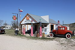
The Fort Phantom Hill Road, a Texas Fort Trail, ran through Nix in the 1850s. The community was settled in the early 1880s on the stagecoach and mail route that ran west from Lampasas. In 1883, David Coterell started a blacksmith shop, and Elizabeth Wallace opened a general store. Wallace was the first postmistress when she opened a post office in her store. The post office was discontinued in 1906. Nix had two mills and gins by 1892, and churches had been established by 1896. Considerable interest arose in drilling for gas and oil in the area during the 1920s and 1930s, though Nix was the site of the county's only dry test well.

By 1947, a combination church/school had been established west of the community. The population of Nix reached its peak of 27 in 1896. In 2000, six people were living in Nix. [2] A Texas historical marker was placed in front of the school in 2007.

Geography

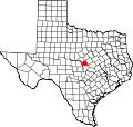
Nix is located on Farm to Market Road 580, 11.5 mi (18.5 km) west of Lampasas in southwestern Lampasas County. [2]

Education

Today the community is served by the Lampasas Independent School District, with elementary-age kids going to Hanna Springs Elementary School.

Related Research Articles

<span class="mw-page-title-main">Mills County, Texas</span> County in Texas, United States


Mills County is a county located in Central Texas, United States. It was created on March 15, 1887, from parts of four existing counties—Brown, Comanche, Hamilton, and Lampasas. The 2020 census reported a population of 4,456. The county seat is Goldthwaite.

Slanesville is an unincorporated community in northeastern Hampshire County in the U.S. state of West Virginia. Slanesville is located at the crossroads of Bloomery Pike with Slanesville Pike and Cold Stream Road. Slanesville Pike and Cold Stream Road formerly made up the Springfield Grade Road that ran from Capon Bridge to Springfield. According to the 2000 census, the Slanesville community has a population of 691.

<span class="mw-page-title-main">Ira, Texas</span> Unincorporated community in Texas, United States

Ira is an unincorporated community in Scurry County, Texas, United States. It lies in the southwestern corner of the county at the junction of State Highway 350 and Farm to Market Road 1606, 10 miles southwest of Snyder, and has an estimated population of 250.

Bend is an unincorporated community in Lampasas and San Saba counties in western Central Texas. Its population was 1,678 as of the 2010 census.

<span class="mw-page-title-main">Clodine, Texas</span> Unincorporated community in Texas, United States

Clodine is an unincorporated community in Fort Bend County, Texas, United States, between the Alief section of Houston and the city of Fulshear.

<span class="mw-page-title-main">Ding Dong, Texas</span> Unincorporated community in Texas, United States

Ding Dong is an unincorporated community in Central Texas. According to the Handbook of Texas, it had a population of 22 in 2000. It is located within the Killeen–Temple–Fort Hood metropolitan area.

<span class="mw-page-title-main">Juliff, Texas</span> Unincorporated community in Texas, United States

Juliff is an unincorporated community situated along Farm to Market Road 521 (FM 521) in eastern Fort Bend County, Texas, United States. The settlement was founded in the 1850s as a shipping point along the Brazos River and the railroad reached there in the same decade. The community received postal service in 1891, and except for a brief closure, retained it until the late 1950s. Starting in the 1930s, Juliff enjoyed a heyday as a place of raucous entertainment after local residents opened several taverns and dance halls. This era ended in the 1960s when the bars relocated to Houston. Sometime later, the railroad that ran alongside FM 521 was discontinued. In December 2013 the community was a collection of homes along the east side of FM 521.

<span class="mw-page-title-main">Leon Springs, Texas</span> Unincorporated community in Texas, United States

Leon Springs is an unincorporated community in Bexar County, Texas, now partially within the city limits of San Antonio. According to the Handbook of Texas, the community had a population of 137 in 2000. It is located within the San Antonio Metropolitan Area.

Oakalla is an unincorporated community in Burnet County, Texas, United States. According to the Handbook of Texas, the community had an estimated population of 45 in 2000.

<span class="mw-page-title-main">Pierceville, Kansas</span> Unincorporated community in Finney County, Kansas

Pierceville is an unincorporated community in Finney County, Kansas, United States. As of the 2020 census, the population of the community and nearby areas was 98. It is located along U.S. Routes 50 and 400, 12 miles (19 km) southeast of Garden City.

<span class="mw-page-title-main">Sage, Bethel, and Pleasant Hill, Texas</span> Unincorporated community

Sage, Bethel, and Pleasant Hill were small closely linked unincorporated communities in Burnet County, Texas. They were close to the small town of Lake Victor and seven or eight miles away from Burnet, Texas.

Adamsville is an unincorporated community in Lampasas County, Texas, United States. According to the Handbook of Texas, the community had a population of 41 in 2000. It is located within the Killeen-Temple-Fort Hood metropolitan area.

Rumley is an unincorporated community in Lampasas County, Texas, United States. According to the Handbook of Texas, the community had a population of eight in 2000. It is located within the Killeen-Temple-Fort Hood metropolitan area.

Maxdale is an unincorporated community in Bell County, in the U.S. state of Texas. According to the Handbook of Texas, only 4 people lived in the community in 2000. It is located within the Killeen-Temple-Fort Hood metropolitan area.

Youngsport is an unincorporated community in Bell County, in the U.S. state of Texas. According to the Handbook of Texas, the community had a population of 40 in 2000. It is located within the Killeen-Temple-Fort Hood metropolitan area.

Hinkle's Ferry is an unincorporated community in Brazoria County, Texas, United States. According to the Handbook of Texas, the community had a population of 35 in 2000. It is located within the Greater Houston metropolitan area.

Mahomet is an unincorporated community in Burnet County, Texas, United States. According to the Handbook of Texas, the community had an estimated population of 47 in 2000.

Izoro is an unincorporated community in Lampasas County, in the U.S. state of Texas. According to the Handbook of Texas, the community had a population of 17 in 2000. It is located within the Killeen-Temple-Fort Hood metropolitan area.

Pidcoke is an unincorporated community in Coryell County, in the U.S. state of Texas. According to the Handbook of Texas, the community had a population of 30 in 2000. It is located within the Killeen-Temple-Fort Hood metropolitan area.

Topsey is an unincorporated community in Coryell County, in the U.S. state of Texas. According to the Handbook of Texas, the community had a population of 20 in 2000. It is located within the Killeen-Temple-Fort Hood metropolitan area.

References

  1. "US Board on Geographic Names". United States Geological Survey. 2007-10-25. Retrieved 2008-01-31.
  2. 1 2 Rhoades, Alice J. "NIX, TX". Texas State Historical Association. Retrieved May 20, 2017.