
The Chihuahuan Desert is a desert ecoregion designation covering parts of northern Mexico and the southwestern United States. It occupies much of far West Texas, the middle to lower Rio Grande Valley and the lower Pecos Valley in New Mexico, and a portion of southeastern Arizona, as well as the central and northern portions of the Mexican Plateau. It is bordered on the west by the Sonoran Desert, the Colorado Plateau, and the extensive Sierra Madre Occidental range, along with northwestern lowlands of the Sierra Madre Oriental range. Its largest, continual expanse is located in Mexico, covering a large portion of the state of Chihuahua, along with portions of Coahuila, north-eastern Durango, the extreme northern part of Zacatecas, and small western portions of Nuevo León. With an area of about 501,896 km2 (193,783 sq mi), it is the largest desert in North America. The desert is fairly young, existing for only 8000 years.

The Sierra Madre Oriental is a mountain range in northeastern Mexico. The Sierra Madre Oriental is part of the American Cordillera, a chain of mountain ranges (cordillera) that consists of an almost continuous sequence of mountain ranges that form the western "backbone" of North America, Central America, South America, and Antarctica.

The Usumacinta River is a river in southeastern Mexico and northwestern Guatemala. It is formed by the junction of the Pasión River, which arises in the Sierra de Santa Cruz and the Salinas River, also known as the Rio Chixoy, or the Rio Negro, which descends from the Sierra Madre de Guatemala. It defines part of the border between Guatemala and the Mexican state of Chiapas, then continues its northwesterly course, meandering through the Mexican state of Tabasco to the Gulf of Mexico.
Laguna Madre is a coastal lagoon in Northeastern Mexico. It extends along the coast of Tamaulipas for over 200 km, from the Río Bravo Delta on the north to the mouth of the Soto la Marina River near La Pesca in the south. Laguna Madre is separated from the Gulf of Mexico on the east by a number of barrier islands, including Barra Los Americanos, Barra Jesús María, and Barra Soto la Marina, and is bounded on the west by the Tamaulipan mainland. It is located in the municipalities of Matamoros, San Fernando, and Soto la Marina.
The WILD Foundation is a 501(c)(3) organization that was founded in 1974 by two South Africans and based in Boulder, Colorado.

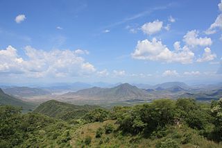
The Sierra Madre Oriental pine–oak forests are a temperate broadleaf and mixed forest ecoregion of northeastern and Central Mexico, extending into the state of Texas in the United States.

The Sierra del Carmen, also called the Sierra Maderas del Carmen, is a northern finger of the Sierra Madre Oriental in the state of Coahuila, Mexico. The Sierra begins at the Rio Grande at Big Bend National Park and extends southeast for about 72 kilometres (45 mi), reaching a maximum elevation of 2,720 metres (8,920 ft). Part of the Sierra del Carmen is protected in the Maderas del Carmen Biosphere Reserve as part of a bi-national effort to conserve a large portion of the Chihuahua Desert in Mexico and Texas.
The Sierra del Burro is the northernmost finger of the Sierra Madre Oriental in the state of Coahuila, Mexico. The Sierra begins at the Rio Grande near Big Bend National Park in Texas and extends southeast for about 70 miles (100 km), reaching a maximum elevation of 2,074 metres (6,804 ft).

The Sierra de Manantlán Biosphere Reserve is a UNESCO Biosphere Reserve in the states of Colima and Jalisco, Mexico. The 139,577 hectares (538.91 sq mi) reserve is located in the transition of the Nearctic and Neotropical realms and encompasses parts of the Sierra Madre del Sur, with a wide range of altitudes, climates and soils. The effects of tectonic and volcanic activities and erosion are notable within the reserve.
The Janos Biosphere Reserve is a nature reserve in Janos, Chihuahua, Mexico. It protects a prairie ecosystem best known for its recovering and reintroduced species most notably the herd of American bison which became the first re-established in Mexico. It is the first federally protected area of Mexico with the main objective of protecting a grassland ecosystem.

The Mexico-United States international park, also known as El Carmen Big Bend Complex, is a proposed transboundary protected area straddling the part of the U.S.–Mexico boundary delineated by the Rio Grande. Proposed by U.S. President Franklin Delano Roosevelt to Mexican President Manuel Ávila Camacho in 1944, the goal remains unfulfilled. The proposed bi-national park is along a 268 mile stretch of the river, which is approximately 14% of the border between Mexico and the United States. It consists of 3 protected areas and parks in Texas and 4 in Mexico, which include Big Bend National Park, the Maderas del Carmen, Ocampo, and Cañón de Santa Elena flora and fauna protection areas, Monumento Río Bravo del Norte, Big Bend Ranch State Park, and Black Gap Management Wildlife Area. As it is a region of protected areas and parks, the El Carmen Big Bend Complex area is the habitat for many types of birds, mammals, plants, and insects. Due to this, the area is a prime spot for ecotourism for both the United States and Mexico along the border. Recent issues of increased border security and environmental concerns have emphasized the need for reopening the discussion, which is currently led by organizations such as the National Park Service in Big Bend National Park, the Sierra Club, and Rotary International.
La Michilía Biosphere Reserve is a protected area in northwestern Mexico. It is located in the Sierra Madre Occidental range in the south of the state of Durango.
Ocampo Flora and Fauna Protection Area is a protected area in northern Mexico. It covers an area of 3442.38 km2 in the state of Coahuila.

Barranca de Metztitlán is a biosphere reserve in the Mexican state of Hidalgo. It is protected for its dramatic scenery of steep cliffs and deep winding canyons, and its distinctive flora and fauna.

The Serranía de Zapalinamé, also known as the Sierra de Zapalinamé is a mountain range and protected area of northeastern Mexico. The city of Saltillo lies immediately north of the mountains.
The biosphere reserves of Mexico are protected natural areas. Some are designated by the national government, while others are internationally designated by UNESCO.

La Sepultura is a biosphere reserve in southern Mexico. It protects a portion of the Sierra Madre de Chiapas range in the state of Chiapas.
The Zona de Protección Forestal en los terrenos que se encuentran en los municipios de La Concordia, Angel Albino Corzo, Villa Flores y Jiquipilas is a natural resources protection area in southern Mexico. It was established in 2009.

El Triunfo Biosphere Reserve is a biosphere reserve in southern Mexico. It is in the Sierra Madre de Chiapas in southern Chiapas.
Zicuirán-Infiernillo Biosphere Reserve is a biosphere reserve in western Mexico. It covers 2,651.18 km2 of the Sierra Madre del Sur range in the state of Michoacán, west of the Balsas River.


