
Invermere is a community in eastern British Columbia, Canada, near the border of Alberta. It is the hub of the Columbia Valley between Golden to the north and Cranbrook to the south. Invermere sits on the northwest shore of Windermere Lake and is a popular summer destination for visitors and second home owners from Edmonton and Calgary.

The Sawatch Range or Saguache Range is a high and extensive mountain range in central Colorado which includes eight of the twenty highest peaks in the Rocky Mountains, including Mount Elbert, at 14,440 feet (4,401 m) elevation, the highest peak in the Rockies.
This is a list of the extreme points of the United Kingdom: the points that are farther north, south, east or west than any other location. Traditionally the extent of the island of Great Britain has stretched "from Land's End to John o' Groats".

This is a list of the extreme points of Ireland – the points that are farthest north, south, east or west in Ireland. It includes the Republic of Ireland and Northern Ireland.

River Neath is a river in south Wales running south west from the point at which its headwaters arising in the Brecon Beacons National Park converge to its mouth at Baglan Bay below Briton Ferry on the east side of Swansea Bay.

Middle Park is a high basin in the Rocky Mountains of north-central Colorado in the United States. It is located in Grand County, on the southwest slope of Rocky Mountain National Park, approximately 50 miles (80 km) west of Boulder.

Podor is the northernmost town in Senegal, lying on Morfil Island between the Sénégal River and Doué River on the border with Mauritania. It was the location of the ancient state Takrur. It is home to a ruined French colonial fort, built in 1854 as a centre for gold trading, and is the birthplace of fashion designer Oumou Sy, as well as musicians Baaba Maal and Mansour Seck.

The River Tawe is a 30 miles (48 km) long river in South Wales. Its headwaters flow initially east from its source below Llyn y Fan Fawr south of Moel Feity in the Black Mountains, the westernmost range of the Brecon Beacons National Park, before the river turns south and then southwest to its estuary at Swansea. Its main tributaries are the right bank Upper and Lower Clydach Rivers and the Afon Twrch. The total area of the catchment is some 246 km2 (95 sq mi). The Tawe passes through a number of towns and villages including Ystradgynlais, Ystalyfera, Pontardawe, and Clydach and meets the sea at Swansea Bay below Swansea. The Tawe Valley is more commonly known as the Swansea Valley.

Cherryville is an unincorporated community in the foothills of the Monashee Mountains in British Columbia with a population of approximately 930. It is located 22 kilometres (14 mi) east of Lumby, along Highway 6.

Lockhart Beach Provincial Park is a provincial park Located 40 km north of Creston, British Columbia, Canada, on BC Highway 3A. "This park and the adjacent Lockhart Creek Provincial Park extend 3 hectares, from the sunny shores of Kootenay Lake to the headwaters of Lockhart Creek. "This small park provides the only easy access to public camping along the south arm of Kootenay Lake. An 18-site campground and day-use area are located near a sand and fine gravel beach."

The Jarbidge River is a 51.8-mile-long (83.4 km), high elevation river in Elko County, Nevada, and Owyhee County, Idaho, in the United States. The Jarbidge originates as two main forks in the Jarbidge Mountains of northeastern Nevada and then flows through basalt and rhyolite canyons on the high plateau of the Owyhee Desert before joining the Bruneau River.

The Moyie is a paddle steamer sternwheeler that operated on Kootenay Lake in British Columbia from 1898 until 1957.
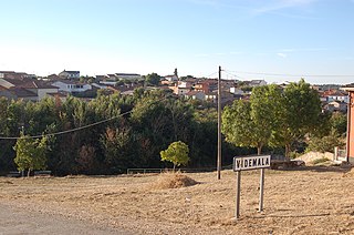
Videmala is a municipality located in the province of Zamora, Castile and León, Spain. According to the 2004 census (INE), the municipality has a population of 216 inhabitants.

The Goat River is a tributary of the Kootenay River in the Canadian province of British Columbia. The river meets the Kootenay near the town of Creston. The Goat River Dam, constructed in the 1930s, was an early source of electricity for the town. Before dikes were built, the river was a major source of spring flooding in the Creston valley.
Bush Pass is a mountain pass in the Canadian Rockies, on the border between the Canadian provinces of Alberta and British Columbia. It is located at the headwaters of the Valenciennes River, formerly known as the South Fork Bush River; the North Fork Bush River is now known as the Bush River.
The Caroaebe River is a river of Roraima state in northern Brazil, near the equator.

The Clearwater River is in the northwestern United States, in north central Idaho. Its length is 74.8 miles (120.4 km), it flows westward from the Bitterroot Mountains along the Idaho-Montana border, and joins the Snake River at Lewiston. In October 1805, the Lewis and Clark Expedition descended the Clearwater River in dugout canoes, putting in at "Canoe Camp," five miles (8 km) downstream from Orofino; they reached the Columbia Bar and the Pacific Ocean about six weeks later.
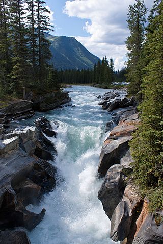
Numa Falls is a waterfall of the Vermilion River located in Kootenay National Park, British Columbia, Canada.

Jumbo Glacier, also known as Jumbo, was a mountain resort municipality within the Regional District of East Kootenay in southeast British Columbia, Canada between 2013 and 2021. It was approximately 55 km (34 mi) west of Invermere near the Commander Glacier and around the headwaters of Jumbo Creek in the Purcell Range of the Columbia Mountains.
