Invermere

Last updated

Invermere
District of Invermere [1]
Invermere bc.jpg
Invermere, British Columbia, with Mount Nelson in the distance
Invermere, British Columbia Location.png
Location of Invermere, British Columbia
Coordinates: 50°30′30″N116°01′49″W / 50.50833°N 116.03028°W / 50.50833; -116.03028
CountryCanada
Province British Columbia
Region East Kootenay
Incorporated1951
Government
  Governing body Invermere Council
   MP Rob Morrison
   MLA Doug Clovechok
Area
[2]
  Land10.75 km2 (4.15 sq mi)
  Urban
3.44 km2 (1.33 sq mi)
Elevation
859 m (2,818 ft)
Population
 (2021) [2]
   District municipality 3,917
  Density364.4/km2 (944/sq mi)
   Urban
3,340
  Urban density971.4/km2 (2,516/sq mi)
Time zone UTC-7 (Mountain Standard (MST))
  Summer (DST) UTC-6 (Mountain Daylight (MDT))
Postal code span
V0A 1K0, V0A 1K7
Area code 250 / 778 / 236
Highways BC-93.svg Hwy 93
BC-95.svg Hwy 95
Waterways Columbia River, Windermere Lake
Website invermere.net OOjs UI icon edit-ltr-progressive.svg

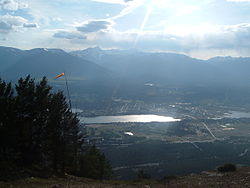
Invermere is a community in eastern British Columbia, Canada, near the border of Alberta. It is the hub of the Columbia Valley between Golden to the north and Cranbrook to the south. Invermere sits on the northwest shore of Windermere Lake and is a popular summer destination for visitors and second home owners from Edmonton and Calgary.

Contents

Geography

Columbia River Wetlands Columbiawetlandsoverview.jpg
Columbia River Wetlands

Invermere is located 14 kilometres (8.7 mi) south of Radium, and 104 kilometres (65 mi) south of Golden and 102 kilometres (63 mi) from the Trans-Canada Highway. Invermere is also 37 kilometres (23 mi) north of Fairmont Hot Springs, 60 kilometres (37 mi) north of Canal Flats, 128 kilometres (80 mi) north of Fort Steele, 130 kilometres (81 mi) north of Kimberley, and 144 kilometres (89 mi) north of the hub of Cranbrook and the Crowsnest Highway. [3] Invermere is situated within the Columbia River Wetlands, North America's largest intact wetland and a Ramsar-designated site. Located in the Rocky Mountain Trench, Invermere is 17.5 kilometres (10.9 mi) from Kootenay National Park, and is near the Purcell Wilderness Conservancy.

Climate

Invermere's climate is characterized by warm summers and cool winters. The Rocky Mountains to the east shield Invermere from the Arctic air in winter, although extreme cold spells do occur on occasion. Spring arrives earlier than on the prairies to the east of the Rocky Mountains. Although warm, summers are variable, with weather alternating between hot, dry spells and cool, showery periods.

Demographics

In the 2021 Census of Population conducted by Statistics Canada, Invermere had a population of 3,917 living in 1,660 of its 2,238 total private dwellings, a change of

Ethnicity

Panethnic groups in the District of Invermere (1996−2021)
Panethnic
group
2021 [5] 2016 [6] 2011 [7] 2006 [8] 2001 [9] 1996 [10]
Pop. %Pop.%Pop.%Pop.%Pop.%Pop.%
European [lower-alpha 1] 3,3702,8152,3802,7302,6902,540
Indigenous 24521015011512070
Southeast Asian [lower-alpha 2] 11590010100
South Asian 30250000
East Asian [lower-alpha 3] 10308035030
African 102000100
Middle Eastern [lower-alpha 4] 0100000
Latin American 0000010
Other/Multiracial [lower-alpha 5] 010010015
Total responses3,7953,2202,6802,8902,8252,665
Total population3,9173,3912,9553,0022,8582,687
Note: Totals greater than 100% due to multiple origin responses

Religion

According to the 2021 census, religious groups in Invermere included: [5]

Arts and culture

The annual Invermere MusicFest takes place on the Pynelogs greenspace for one weekend every August. The two-day Festival attracts hundreds of people each day and delivers a high caliber of Canadian and international musical talent, including The Dead South and Lindi Ortega in 2018.

Sports and recreation

The Columbia Valley Chamber of Commerce in Invermere Columbia Valley Chamber of Commerce in Invermere.jpg
The Columbia Valley Chamber of Commerce in Invermere
Hockey

The Columbia Valley Rockies play in Invermere. Former New York Islanders and University of Denver goaltender Wade Dubielewicz was born in Invermere.

ClubLeagueSportVenueEstablishedChampionships
Columbia Valley Rockies KIJHL Ice hockey Eddie Mountain Memorial Arena19784
Skiing
Skating

The longest ice skating trail in the world can be found on the Lake Windermere Whiteway. The naturally frozen trail measures 29.98 kilometres (18.63 mi). [11]

Golfing

Invermere is a major centre for golf.

Gliding and soaring
Invermere Airport Inveremereairport.jpg
Invermere Airport

The Invermere Airport is home to the non-profit Canadian Rockies Soaring Club. The club is active during the summer months, when it welcomes dozens of student pilots and private owners. The Invermere Soaring Centre is a separate commercial operation which provides aerotowing services and glider rides to the general public.

The local area is also a popular destination for other non-motorized forms of flying including hang-gliding and paragliding. There are designated launch sites at nearby Mount Swansea.

Curling

The Valley is host to the biggest[ citation needed ] outdoor bonspiel in Canada every January. The spiel is held on the frozen Windermere Lake. The curling club is also host to many leagues and bonspiels throughout the season.

Hot springs

Hot springs are numerous in the area, with the major developed ones being Fairmont and Radium Hot Springs; the latter is located inside Kootenay National Park.

Less developed 'wilderness' hot springs can be found in the southern Columbia Valley, in Whiteswan Lake Provincial Park. [12] Lussier Hot Springs is located 74 kilometres (46 mi) south of Invermere and can be accessed from the Whiteswan Forestry Road. Ram Creek Warm Springs, a less visited and cooler natural spring, can also be accessed along the same route.

Media

Looking north on BC93 / BC95 at Invermere Invermere BC looking north on BC93 BC95.jpg
Looking north on BC93 / BC95 at Invermere

Invermere is home to one newspaper, the Columbia Valley Pioneer . On July 1, 2017, the "Pioneer" (founded in 2004) and the Invermere Valley Echo (founded in 1956) merged to one paper retaining the Columbia Valley Pioneer designation. The "Pioneer" serves the Columbia Valley region, from Spillimacheen in the north to Canal Flats in the south and is published once a week, every Thursday.

Notable people

See also

Notes

  1. Statistic includes all persons that did not make up part of a visible minority or an indigenous identity.
  2. Statistic includes total responses of "Filipino" and "Southeast Asian" under visible minority section on census.
  3. Statistic includes total responses of "Chinese", "Korean", and "Japanese" under visible minority section on census.
  4. Statistic includes total responses of "West Asian" and "Arab" under visible minority section on census.
  5. Statistic includes total responses of "Visible minority, n.i.e." and "Multiple visible minorities" under visible minority section on census.

Related Research Articles

<span class="mw-page-title-main">Fernie, British Columbia</span> City in British Columbia, Canada

Fernie is a city in the Elk Valley area of the East Kootenay region of southeastern British Columbia, Canada, located on BC Highway 3 on the western approaches to the Crowsnest Pass through the Rocky Mountains. Founded in 1898 and incorporated as the City of Fernie in July 1904, the municipality has a population of over 5,000 with an additional 2,000 outside city limits in communities under the jurisdiction of the Regional District of East Kootenay. A substantial seasonal population swells the city during the winter months.

<span class="mw-page-title-main">Cranbrook, British Columbia</span> City in British Columbia, Canada

Cranbrook is a city in southeast British Columbia, Canada, located approximately 10 km southwest of the confluence of the Kootenay River and the St. Mary's River. It is the largest urban centre in the region known as the East Kootenay. As of 2016, Cranbrook's population is 20,499 with a census agglomeration population of 27,040. It is the location of the headquarters of the Regional District of East Kootenay and also the location of the regional headquarters of various provincial ministries and agencies, notably the Rocky Mountain Forest District.

<span class="mw-page-title-main">Sparwood</span> District municipality in British Columbia, Canada

Sparwood is a district municipality in the Canadian province of British Columbia. It is the second-largest community on the Elk River.

<span class="mw-page-title-main">Osoyoos</span> Town in British Columbia, Canada

Osoyoos is the southernmost town in the Okanagan Valley in British Columbia between Penticton and Omak. The town is 3.6 km (2.2 mi) north of the United States border with Washington state and is adjacent to the Osoyoos Indian reserve. The origin of the name Osoyoos was the word sw̓iw̓s meaning "narrowing of the waters" in the local Okanagan language (Syilx'tsn). The "O-" prefix is not indigenous in origin and was attached by settler-promoters wanting to harmonize the name with other place names beginning with O in the Okanagan region. There is one local newspaper, the Osoyoos Times.

<span class="mw-page-title-main">Golden, British Columbia</span> Town in British Columbia, Canada

Golden is a town in southeastern British Columbia, Canada, 262 kilometres (163 mi) west of Calgary, Alberta, and 713 kilometres (443 mi) east of Vancouver.

<span class="mw-page-title-main">Duncan, British Columbia</span> City in British Columbia, Canada

Duncan is a city on southern Vancouver Island in British Columbia, Canada. It is the smallest city by area in Canada. It was incorporated in 1912.

<span class="mw-page-title-main">Summerland, British Columbia</span> Town in British Columbia, Canada

Summerland is a town on the west side of Okanagan Lake in the interior of British Columbia, Canada. The district is between Peachland to the north and Penticton to the south. The largest centre in the region is Kelowna, approximately 50 km (31 mi) to the north, and Vancouver is approximately 425 km (264 mi) away to the west. The district is famous for "Bottleneck drive", a system of roads connecting various wineries.

<span class="mw-page-title-main">Regional District of East Kootenay</span> Regional district in British Columbia, Canada

The Regional District of East Kootenay (RDEK) is a regional district in the Canadian province of British Columbia, Canada. In the 2016 census, the population was 60,439. Its area is 27,542.69 km2 (10,634.29 sq mi). The regional district offices are in Cranbrook, the largest community in the region. Other important population centres include the cities of Kimberley and Fernie, and the district municipality of Invermere and Sparwood. Despite its name, the regional district does not include all of the region known as the East Kootenay, which includes the Creston Valley and the east shore of Kootenay Lake.

<span class="mw-page-title-main">Regional District of Central Okanagan</span> Regional district in British Columbia, Canada

The Regional District of Central Okanagan (RDCO) is a regional district in the Canadian province of British Columbia, representing two unincorporated Electoral Areas of Central Okanagan East and Central Okanagan West, along with the member municipalities of the City of Kelowna, City of West Kelowna the District of Lake Country, the District of Peachland and Westbank First Nation. The RDCO office is located in Kelowna.

<span class="mw-page-title-main">North Cowichan</span> District municipality in British Columbia, Canada

North Cowichan is a district municipality established in 1873 on Vancouver Island, in British Columbia, Canada. The municipality is part of the Cowichan Valley Regional District. North Cowichan is noted for a landscape including forests, beaches, rivers, and lakes. The municipality encompasses the communities of Chemainus; Westholme; Crofton; Maple Bay; and "the South End". The latter is an informal name for a built-up area which is essentially a suburb of the City of Duncan, a separate municipality.

<span class="mw-page-title-main">Kimberley, British Columbia</span> City in British Columbia, Canada

Kimberley is a city in southeast British Columbia, Canada along Highway 95A between the Purcell and Rocky Mountains. Kimberley was named in 1896 after the Kimberley mine in South Africa. From 1917 to 2001, it was the home to the world's largest lead-zinc mine, the Sullivan Mine. Now it is mainly a tourist destination and home to the Kimberley Alpine Resort, a ski area and Kimberley's Underground Mining Railway that features a 750-foot-long (230 m) underground mining interpretive centre complete with operational 3 ft narrow-gauge railway equipment. Recreational pursuits include world-class skiing, snowboarding, snowmobiling, fishing, whitewater rafting, kayaking, biking, hiking and golfing on championship golf courses. The city has the largest urban park in Canada. At 1,977 acres (800 ha), the Kimberley Nature Park is the largest incorporated park in Canada.

<span class="mw-page-title-main">Columbia-Shuswap Regional District</span> Regional district in British Columbia, Canada

The Columbia–Shuswap Regional District is a regional district in the Canadian province of British Columbia, located in the Southern Interior region on the Trans-Canada Highway between Vancouver and Calgary, Alberta. The regional district borders the Province of Alberta across the Rocky Mountains.

<span class="mw-page-title-main">Cowichan Valley Regional District</span> Regional district in British Columbia, Canada

The Cowichan Valley Regional District is a regional district in the Canadian province of British Columbia is on the southern part of Vancouver Island, bordered by the Nanaimo and Alberni-Clayoquot Regional Districts to the north and northwest, and by the Capital Regional District to the south and east. As of the 2021 Census, the Regional District had a population of 89,013. The regional district offices are in Duncan.

<span class="mw-page-title-main">Enderby, British Columbia</span> City in British Columbia, Canada

The City of Enderby is in the North Okanagan region of the Canadian province of British Columbia, between Armstrong and Salmon Arm. It is approximately 80 km north of Kelowna and 130 km east of Kamloops. Highway 97A passes through Enderby and the Shuswap River marks the eastern and northeastern limits of the City. There are two major schools in Enderby: M.V. Beattie Elementary School and A.L. Fortune Secondary School. M.V. Beattie Elementary School was rebuilt in 2012.

<span class="mw-page-title-main">Mackenzie, British Columbia</span> District municipality in British Columbia, Canada

Mackenzie is a district municipality within the Fraser-Fort George Regional District in central British Columbia, Canada. The community is located at the south end of Williston Lake. The townsite, established by Alexandra Forest Industries and Cattermole Timber, was named for Sir Alexander MacKenzie (1764–1820).

<span class="mw-page-title-main">Grand Forks, British Columbia</span> City in British Columbia, Canada

Grand Forks is a city in the Boundary Country of the West Kootenay region of British Columbia, Canada. It is located at the confluence of the Granby and Kettle Rivers, a tributary of the Columbia River. The city is just north of the Canada–United States border, approximately 500 km (310 mi) from Vancouver and 200 km (120 mi) from Kelowna and 23 km (14 mi) west of the resort area of Christina Lake by road.

<span class="mw-page-title-main">Northern Rockies Regional Municipality</span> Regional district in British Columbia, Canada

The Northern Rockies Regional Municipality (NRRM), formerly the Northern Rockies Regional District (NRRD), and before that the Fort Nelson–Liard Regional District, is a municipality in northeastern British Columbia, Canada. Although portrayed as a regional municipality in its official name, and existing on the same administrative level as a regional district, it is actually classified as a district municipality. The NRRM's offices are located in Fort Nelson, formerly an incorporated town that amalgamated with the NRRD on February 6, 2009, to form the NRRM. With the Peace River Regional District as the southern part, it was the northern part of the Peace River-Liard Regional District, which was split into two on October 31, 1987.

<span class="mw-page-title-main">Houston, British Columbia</span> District municipality in British Columbia, Canada

Houston is a forestry, mining and tourism town in the Bulkley Valley of the Northern Interior of British Columbia, Canada. Its population as of 2021 was 3,052, with approximately 2,000 in the surrounding rural area. It is known as the "steelhead capital" and it has the world's largest fly fishing rod. Houston's tourism industry is largely based on ecotourism and Steelhead Park, situated along Highway 16. Houston is named in honour of the pioneer newspaperman John Houston.

The District of Kent is a district municipality located 116 kilometres (72 mi) east of Vancouver, British Columbia. Part of the Fraser Valley Regional District, Kent consists of several communities, the largest and most well-known being Agassiz—the only town in the municipality—Harrison Mills, Kilby, Mount Woodside, Kent Prairie, Sea Bird Island and Ruby Creek. Included within the municipality's boundaries are several separately-governed Indian reserves, including the Seabird Island First Nation's reserves on and around the island of the same name.

Lake Cowichan is a town located on the east end of Cowichan Lake and, by highway, is 27 kilometres (17 mi) west of Duncan, British Columbia. The town of Lake Cowichan was incorporated in 1944. The Cowichan River flows through the middle of the town. Cowichan River is designated as a Heritage River.

References

  1. "British Columbia Regional Districts, Municipalities, Corporate Name, Date of Incorporation and Postal Address" (XLS). British Columbia Ministry of Communities, Sport and Cultural Development. Archived from the original on July 13, 2014. Retrieved November 2, 2014.
  2. 1 2 "Population and dwelling counts, for Canada, provinces and territories, and census subdivisions (municipalities), 2021 census – 100% data (British Columbia)". Statistics Canada. February 9, 2022. Retrieved February 9, 2022.
  3. "Invermere | Canadian Rockies | Kootenay Rockies". Travel British Columbia. Retrieved 2022-10-19.
  4. "Population and dwelling counts: Canada, provinces and territories, and census subdivisions (municipalities), British Columbia". Statistics Canada. February 9, 2022. Retrieved February 20, 2022.
  5. 1 2 Government of Canada, Statistics Canada (2022-10-26). "Census Profile, 2021 Census of Population". www12.statcan.gc.ca. Retrieved 2022-11-11.
  6. Government of Canada, Statistics Canada (2021-10-27). "Census Profile, 2016 Census". www12.statcan.gc.ca. Retrieved 2023-03-21.
  7. Government of Canada, Statistics Canada (2015-11-27). "NHS Profile". www12.statcan.gc.ca. Retrieved 2023-03-21.
  8. Government of Canada, Statistics Canada (2019-08-20). "2006 Community Profiles". www12.statcan.gc.ca. Retrieved 2023-03-21.
  9. Government of Canada, Statistics Canada (2019-07-02). "2001 Community Profiles". www12.statcan.gc.ca. Retrieved 2023-03-21.
  10. Government of Canada, Statistics Canada (2019-06-04). "Electronic Area Profiles Profile of Census Divisions and Subdivisions, 1996 Census". www12.statcan.gc.ca. Retrieved 2023-03-21.
  11. "Longest ice skating trail". www.guinnessworldrecords.com. Retrieved July 29, 2014.
  12. "Whiteswan Lake Provincial Park website".

50°30′30″N116°1′49″W / 50.50833°N 116.03028°W / 50.50833; -116.03028 (Invermere)