
A batholith is a large mass of intrusive igneous rock, larger than 100 km2 (40 sq mi) in area, that forms from cooled magma deep in the Earth's crust. Batholiths are almost always made mostly of felsic or intermediate rock types, such as granite, quartz monzonite, or diorite.

Cape Breton Highlands National Park is a Canadian national park on northern Cape Breton Island in Nova Scotia. The park was the first national park in the Atlantic provinces of Canada and covers an area of 948 square kilometres (366 sq mi). It is one of 42 in Canada's system of national parks.
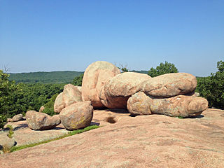
Elephant Rocks State Park is a state-owned geologic reserve and public recreation area encompassing an outcropping of Precambrian granite in the Saint Francois Mountains in the U.S. state of Missouri. The state park is named for a string of large granite boulders which resemble a train of pink circus elephants. The park was created following the donation of the land to the state in 1967 by geologist Dr. John Stafford Brown. The park is used for picnicking, rock climbing, and trail exploration. It is managed by the Missouri Department of Natural Resources.
Nitinat River Provincial Park is a provincial park in the Canadian province of British Columbia on Vancouver Island.
Spatsizi Plateau Wilderness Provincial Park is located in the northern portion of British Columbia, Canada, approximately 698, 659 hectares and encompasses the Spatsizi River and Gladys Lake Ecological Reserve. The park is a designated protected area that is intended for the conservation and research on caribou, grizzly bears, fish, and other wildlife species populations. Before the provincial park's establishment in 1975, the area was a historical hunting ground for local Indigenous communities like the Tahltan First Nations. It is the second largest provincial park in British Columbia.

Mount Price is a small stratovolcano in the Garibaldi Ranges of the Pacific Ranges in southwestern British Columbia, Canada. It has an elevation of 2,049 metres and rises above the surrounding landscape on the western side of Garibaldi Lake in New Westminster Land District. The mountain contains a number of subfeatures, including Clinker Peak on its western flank, which was the source of two thick lava flows between 15,000 and 8,000 years ago that ponded against glacial ice. These lava flows are structurally unstable, having produced large landslides as recently as the 1850s. A large provincial park surrounds Mount Price and other volcanoes in its vicinity. It lies within an ecological region that surrounds much of the Pacific Ranges.

Indian Arm is a steep-sided glacial fjord adjacent to the city of Vancouver in southwestern British Columbia. Formed during the last Ice Age, it extends due north from Burrard Inlet, between the communities of Belcarra and the District of North Vancouver, then on into mountainous wilderness. Burrard Inlet and the opening of Indian Arm was mapped by Captain George Vancouver and fully explored days later by Dionisio Alcalá Galiano in June 1792.
The Okanagan Highland is an elevated hilly plateau area in British Columbia, Canada, and the U.S. state of Washington. Rounded mountains with elevations up to 8,000 ft (2,400 m) above sea level and deep, narrow valleys are characteristic of the region.

Mount Silverthrone, officially named Silverthrone Mountain, is a mountain in the Pacific Ranges of the Coast Mountains of British Columbia, Canada, located over 320 km (200 mi) northwest of the city of Vancouver and about 50 km (30 mi) west of Mount Waddington, British Columbia, Canada. It is the highest peak in the Ha-Iltzuk Icefield, which is the largest icefield in the Coast Mountains south of the Alaska Panhandle.

Level Mountain is a large volcanic complex in the Northern Interior of British Columbia, Canada. It is located 50 kilometres north-northwest of Telegraph Creek and 60 kilometres west of Dease Lake on the Nahlin Plateau. With a maximum elevation of 2,164 metres, it is the second-highest of four large complexes in an extensive north–south trending volcanic region. Much of the mountain is gently-sloping; when measured from its base, Level Mountain is about 1,100 metres tall, slightly taller than its neighbour to the northwest, Heart Peaks. The lower, broader half of Level Mountain consists of a shield-like structure while its upper half has a more steep, jagged profile. Its broad summit is dominated by the Level Mountain Range, a small mountain range with prominent peaks cut by deep valleys. These valleys serve as a radial drainage for several small streams that flow from the mountain. Meszah Peak is the only named peak in the Level Mountain Range.
The Franklin Glacier Complex is a deeply eroded volcano in the Waddington Range of southwestern British Columbia, Canada. Located about 65 km (40 mi) northeast of Kingcome, this sketchily known complex resides at Franklin Glacier near Mount Waddington. It is over 2,000 m (6,600 ft) in elevation and because of its considerable overall altitude, a large proportion of the complex is covered by glacial ice.

The Mount Edziza volcanic complex is a group of volcanoes and associated lava flows in northwestern British Columbia, Canada. Located on the Tahltan Highland, it is 40 kilometres southeast of Telegraph Creek and 85 kilometres southwest of Dease Lake. The complex encompasses a broad, steep-sided lava plateau that extends over 1,000 square kilometres. Its highest summit is 2,786 metres in elevation, making the MEVC the highest of four large complexes in an extensive north–south trending volcanic region. It is obscured by an ice cap characterized by several outlet glaciers that stretch out to lower altitudes.

The Britannia Range is a small mountain range of the Coast Mountains that runs along the eastern shore of Howe Sound just north of Vancouver, British Columbia, Canada. It is a subrange of the Pacific Ranges and often considered part of the North Shore Mountains. The range is bounded by the Howe Sound to the west, the Stawamus River to the north, Loch Lomond on the upper Seymour River to the east, and Deeks Lake to the south. However, some official maps extend the range further south of these boundaries and many local sources such as hiking guidebooks will often include all of the peaks along the Howe Sound between Deeks Lake and Cypress Mountain as part of the range.

Mount Prindle is a granitic mountain in the Yukon–Tanana Uplands, and is located approximately 45 miles (72 km) north-northeast of Fairbanks, Alaska. The plutons that form the core of the Mount Prindle massif are Late Cretaceous or early Tertiary age. These plutons intruded older metamorphic rocks. Mount Prindle exhibits classic glacial landforms, unlike most of the surrounding Yukon–Tanana Uplands. It is in the Circle Mining District and many of the surrounding creeks have been or are being mined for placer gold. The area has also been prospected for tin and rare earth minerals. Mine roads and hiking trails provide access to the mountain. A 900 feet (270 m) granite wall on an eastern spur of the massif is an attraction for rock climbers.

The Volcano, also known as Lava Fork volcano, is a small cinder cone in the Boundary Ranges of the Coast Mountains in northwestern British Columbia, Canada. It is located approximately 60 km (40 mi) northwest of the small community of Stewart near the head of Lava Fork. With a summit elevation of 1,656 m (5,433 ft) and a topographic prominence of 311 m (1,020 ft), it rises above the surrounding rugged landscape on a remote mountain ridge that represents the northern flank of a glaciated U-shaped valley.

The Canadian Cascade Arc, also called the Canadian Cascades, is the Canadian segment of the North American Cascade Volcanic Arc. Located entirely within the Canadian province of British Columbia, it extends from the Cascade Mountains in the south to the Coast Mountains in the north. Specifically, the southern end of the Canadian Cascades begin at the Canada–United States border. However, the specific boundaries of the northern end are not precisely known and the geology in this part of the volcanic arc is poorly understood. It is widely accepted by geologists that the Canadian Cascade Arc extends through the Pacific Ranges of the Coast Mountains. However, others have expressed concern that the volcanic arc possibly extends further north into the Kitimat Ranges, another subdivision of the Coast Mountains, and even as far north as Haida Gwaii.
The Dudidontu River is a tributary of the Nahlin River in northwest part of the province of British Columbia, Canada. It joins the Nahlin River, which forms the Inklin River, one of the main tributaries of the Taku River. The Dudidontu River's watershed covers 964 km2 (372 sq mi), and its mean annual discharge is 15.4 m3/s (540 cu ft/s). Almost half of the Dudidontu's flow comes from its main tributary, Kakuchuya Creek, and Kakuchuya Creek's main tributary, Matsatu Creek. The mouth of the Dudidontu River is located about 150 km (93 mi) northeast of Juneau, Alaska and about 110 km (68 mi) northwest of Telegraph Creek, British Columbia.
Hatin Lake is a small low-lying lake on the Nahlin Plateau in Cassiar Land District of the Northern Interior of British Columbia, Canada. It is an expansion of the Koshin River, which flows north from nearby Level Mountain into the Nahlin River. The Callison Ranch lies on the eastern side of Hatin Lake.
Granite Lake is a small lake in the Pacific Ranges of the Coast Mountains in southwestern British Columbia, Canada. It is located 12 km (7.5 mi) east-northeast of the city of Powell River in New Westminster Land District. It lies west of the south end of Horseshoe Lake.
