
The following is an alphabetical list of articles related to the Canadian province of British Columbia.

British Columbia is the westernmost province of Canada, bordered by the Pacific Ocean. With an area of 944,735 km2 (364,764 sq mi) it is Canada's third-largest province. The province is almost four times the size of the United Kingdom and larger than every United States state except Alaska. It is bounded on the northwest by the U.S. state of Alaska, directly north by Yukon and the Northwest Territories, on the east by Alberta, and on the south by the U.S. states of Washington, Idaho, and Montana. Formerly part of the British Empire, the southern border of British Columbia was established by the 1846 Oregon Treaty. The province is dominated by mountain ranges, among them the Canadian Rockies but dominantly the Coast Mountains, Cassiar Mountains, and the Columbia Mountains. Most of the population is concentrated on the Pacific coast, notably in the area of Vancouver, located on the southwestern tip of the mainland, which is known as the Lower Mainland. It is the most mountainous province of Canada.

The Golden Hinde is a mountain located in the Vancouver Island Ranges on Vancouver Island, British Columbia, Canada. At 2,195 metres (7,201 ft), it is the highest peak on the island. The peak is popular with experienced backcountry-climbers, having been first ascended in 1913. The mountain is made of basalt which is part of the Karmutsen Formation.

Sooke Mountain Provincial Park is a Class B provincial park located at the southern end of Vancouver Island in British Columbia, Canada. The park was established on June 25, 1928, to protect local wildlife and preserve the scenic wilderness of the area. Sooke Mountain is now part of the larger Sea to Sea Green Blue Belt surrounding Greater Victoria.

Strathcona Provincial Park is the oldest provincial park in British Columbia, Canada, and the largest on Vancouver Island. Founded in 1911, the park was named for Donald Alexander Smith, 1st Baron Strathcona and Mount Royal, a wealthy philanthropist and railway pioneer. It lies within the Strathcona Regional District. The Clayoquot Sound Biosphere Reserve, established in 2000, includes three watersheds in the western area of the park.

Strathcona-Westmin Provincial Park is a Class B provincial park located at the southern extremity of Buttle Lake on Vancouver Island in British Columbia, Canada. The park was separated out from Strathcona Provincial Park by BC Parks in 1987 so that mining operations could proceed within park boundaries. Strathcona-Westmin is expected to be reabsorbed into Strathcona Provincial Park once mining operations cease.

Buttle Lake is a lake on Vancouver Island in Strathcona Regional District, British Columbia, Canada. It is about 23 kilometres (14 mi) long and 1.5 kilometres (0.9 mi) wide, has an area of 28 square kilometres (11 sq mi), is up to 120 metres (394 ft) deep, and lies at an elevation of 221 metres (725 ft). The lake is located between Campbell River and Gold River in Strathcona Provincial Park. The lake is the headwaters of the Campbell River.

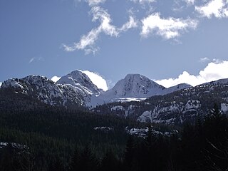
Mount Colonel Foster is a mountain located on Vancouver Island in Strathcona Regional District, British Columbia, Canada. At 2,135 metres (7,005 ft), it is the fourth highest peak on the island. It is one of the nine Island Qualifiers.
Kings Peak is a mountain located on Vancouver Island in British Columbia, Canada. The mountain is located in Strathcona Provincial Park 25 km (16 mi) northeast of Gold River and 2 km (1 mi) north of Elkhorn Mountain.
The Insular Mountains are a range of mountains in the Pacific Coast Ranges on the Coast of British Columbia, Canada, comprising the Vancouver Island Ranges and Queen Charlotte Mountains. The Insular Mountains are rugged, particularly on Vancouver Island where peaks in Strathcona Provincial Park rise to elevations of more than 2,000 m (6,562 ft). The highest of these mountains is Golden Hinde on Vancouver Island, which rises to 2,196.818 m (7,207 ft).

Alberni Valley is a broad valley located at the head of Alberni Inlet on Vancouver Island in British Columbia, Canada. It is home to Port Alberni, Sproat Lake and other outlining areas. The term is largely used as a synonym for Greater Port Alberni and adjoining communities but is used in a larger regional sense as well. Various local organizations and companies use the term "Alberni Valley" in their name, e.g. the Alberni Valley Times and Alberni Valley News newspapers the Alberni Valley Chamber of Commerce and the Alberni Valley Bulldogs minor hockey team. The Canadian pioneer, Joe Drinkwater lived in Alberni Valley during the late nineteenth and early twentieth centuries.
Karmutzen Mountain is a mountain located in the Karmutzen Range on Vancouver Island in British Columbia. It is to the west of Nimpkish Lake which was formerly known as Karmutzen Lake.

The Red Pillar is a mountain on Vancouver Island, British Columbia, Canada, located 33 km (21 mi) southwest of Courtenay and 17 km (11 mi) south of Mount Albert Edward.

Nine Peaks is a mountain featuring numerous peaks on Vancouver Island, British Columbia, Canada, located 40 km (25 mi) northeast of Tofino and 4 km (2 mi) southeast of Big Interior Mountain.

Mount Tom Taylor is a mountain on Vancouver Island, British Columbia, Canada, located 41 km (25 mi) northeast of Tofino and 27 km (17 mi) southwest of Mount Albert Edward. This mountain is composed of granite, which is nearly unique in Strathcona Provincial Park. Several multi-pitch alpine climbing routes have been established on its steep SE flanks.

Castlecrag Mountain is a mountain located on Vancouver Island, British Columbia. Castlecrag Mountain is located South of Moat Lake, 1.6 km West of Mount Frink along the same ridge line.

The Comox Glacier is a glacier on Vancouver Island, British Columbia, Canada, located 30 km (19 mi) southwest of Courtenay and 1 km (0.62 mi) west of Argus Mountain.
Jack Shark Lake is a lake located on Vancouver Island on the west side of Augerpoint Mountain west of Mount Albert Edward in Strathcona Provincial Park.

Upper Campbell Lake is a reservoir on Vancouver Island in British Columbia, Canada. The lake was flooded in 1958 for a large hydroelectric project, which raised the water level by 30 metres (98 ft). Crest Creek and headwaters of the Heber River are diverted into the lake. Part of the lake and its watershed is located in Strathcona Provincial Park, and the Strathcona Park Lodge is located on the eastern side. Freshwater fish species in the lake include Cutthroat trout, Rainbow trout and Dolly varden.
