100 Mile House is a town and district municipality located in the South Cariboo region of central British Columbia, Canada.

The Deschutes River in central Oregon is a major tributary of the Columbia River. The river provides much of the drainage on the eastern side of the Cascade Range in Oregon, gathering many of the tributaries that descend from the drier, eastern flank of the mountains. The Deschutes provided an important route to and from the Columbia for Native Americans for thousands of years, and then in the 19th century for pioneers on the Oregon Trail. The river flows mostly through rugged and arid country, and its valley provides a cultural heart for central Oregon. Today the river supplies water for irrigation and is popular in the summer for whitewater rafting and fishing.

Flaming Gorge Reservoir is the largest reservoir in Wyoming, on the Green River, impounded behind the Flaming Gorge Dam. Construction on the dam began in 1958 and was completed in 1964. The reservoir stores 3,788,900 acre-feet (4.6735×10⁹ m3) of water when measured at an elevation of 6,040 feet (1,841 m) above sea-level (maximum).

Ross Lake is a large reservoir in the North Cascade mountains of northern Washington state, United States, and southwestern British Columbia, Canada. The lake runs approximately north–south, is 23 miles (37 km) long, up to 1.5 miles (2.5 km) wide, and the full reservoir elevation is 1,604 feet above sea level.

The rainbow trout is a species of trout native to cold-water tributaries of the Pacific Ocean in Asia and North America. The steelhead is an anadromous (sea-run) form of the coastal rainbow trout(O. m. irideus) or Columbia River redband trout (O. m. gairdneri) that usually returns to fresh water to spawn after living two to three years in the ocean. Freshwater forms that have been introduced into the Great Lakes and migrate into tributaries to spawn are also called steelhead.

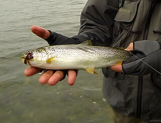
The cutthroat trout(Oncorhynchus clarkii) is a fish species of the family Salmonidae native to cold-water tributaries of the Pacific Ocean, Rocky Mountains, and Great Basin in North America. As a member of the genus Oncorhynchus, it is one of the Pacific trout, a group that includes the widely distributed rainbow trout. Cutthroat trout are popular gamefish, especially among anglers who enjoy fly fishing. The common name "cutthroat" refers to the distinctive red coloration on the underside of the lower jaw. The specific name clarkii was given to honor explorer William Clark, coleader of the Lewis and Clark Expedition.
Savona is a small community located at the west end of Kamloops Lake, where the Thompson River exits it. It is approximately halfway between Kamloops and Cache Creek along the Trans-Canada Highway. The countryside surrounding the community is semi-arid grasslands and hills, which support cattle ranching and agriculture. It has about 2000 hours of sunshine and less than 12 inches of precipitation a year. It has a population of approximately 650.

The Salmon River is a small river north of Syracuse in Upstate New York, the United States. It is a popular and economically important sportfishing destination, and the most heavily fished of New York's Lake Ontario tributaries. From its headwaters in the Tug Hill region of New York, it flows 44 miles (71 km) westward through two hydroelectric dams and over the 110-foot (34 m) Salmon River Falls before it empties into eastern Lake Ontario at Port Ontario in Oswego County. The Salmon River watershed drains approximately 280 square miles (730 km2).

Flathead Lake is a large natural lake in northwest Montana.

The West Canada Creek is a 76-mile-long (122 km) river in upstate New York, United States. West Canada Creek is an important water way in Hamilton, Oneida, and Herkimer counties, draining the south part of the Adirondack Mountains before emptying into the Mohawk River near the Village of Herkimer. The name "Canada" is derived from an Iroquoian word for "village" (Kanata).

Houston is a forestry, mining and tourism town in the Bulkley Valley of the Northern Interior of British Columbia, Canada. Its urban population is approximately 3600 people, with approximately 2000 in the surrounding rural area. It is known as the "steelhead capital" and it has the world's largest fly fishing rod. Houston's tourism industry is largely based on ecotourism and Steelhead Park, situated along Highway 16. Houston is named in honour of the pioneer newspaperman John Houston.
Kikomun Creek Provincial Park is a provincial park in British Columbia, Canada.
Tłu Tue - Maxhamish Lake Provincial Park and Protected Area is a 27,516-hectare (67,990-acre) provincial park in British Columbia, Canada.

White Lake Provincial Park is a provincial park in British Columbia, Canada and is located 10 kilometres northeast of Balmoral, British Columbia. Established in 1965, the park is just west of Cedar Creek Camp, a park owned by the not-for-profit organisation of People In Motion. The lake is popular with anglers fishing for rainbow trout; in terms of angler days, it is one of the top three fishing lakes in the province.
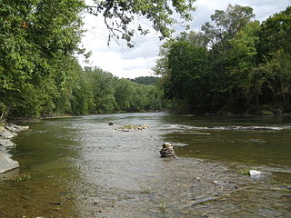
Fishing Creek is a 29.98-mile (48.25 km) long tributary of the Susquehanna River in Columbia County, Pennsylvania, in the United States. It joins the Susquehanna River near the census-designated place of Rupert and the town of Bloomsburg. The watershed has an area of 385 square miles (1,000 km2).
The coastal cutthroat trout, also known as the sea-run cutthroat trout, blue-back trout or harvest trout, is one of the several subspecies of cutthroat trout found in Western North America. The coastal cutthroat trout occurs in four distinct forms. A semi-anadromous or sea-run form is the most well known. Freshwater forms occur in both large and small rivers and streams and lake environments. The native range of the coastal cutthroat trout extends south from the southern coastline of the Kenai Peninsula in Alaska to the Eel River in Northern California. Coastal cutthroat trout are resident in tributary streams and rivers of the Pacific basin and are rarely found more than 100 miles (160 km) from the ocean.

Nimpo Lake is a freshwater lake in the Chilcotin District of British Columbia, Canada. It is located 300 kilometres west of Williams Lake on the Chilcotin Highway and is approximately 160 kilometres east of Bella Coola. The lake is over 11 kilometres long with several protected bays and has an area of 9.88 km2.

Canim Lake is a lake in British Columbia, Canada. Its west end is 36 km (22.4 mi) northeast of 100 Mile House. "Canim" means a type of large canoe in the Chinook Jargon. Canim Lake is 26.5 km (16.5 mi) long. It is also part of the territory of the Shuswap First Nation where the ancestors are part of the Lake Division of the Shuswap nation of the Interior Nations of British Columbia. The Reilly Commission states that the 2,029 hectares region around Canim Lake are set aside for the Shuswap First Nation. In the summer of 1995, there was an archaeological evidence of an ancient civilization and evidence of carbon dated as 4,300 old.

Heart Lake el. 7,461 feet (2,274 m) is a large backcountry lake, nestled at the base of Mount Sheridan in Yellowstone National Park. Heart Lake is in the Snake River drainage and is drained by the Heart River.
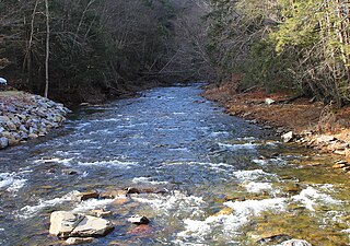
West Branch Fishing Creek is one of the northernmost major tributaries of Fishing Creek in Sullivan County, Pennsylvania and Columbia County, Pennsylvania, in the United States. It is 11.1 miles (17.9 km) long and flows through Davidson Township, Sullivan County and Sugarloaf Township, Columbia County. The creek's watershed has an area of 33.5 square miles, nearly all of which is forested land.
