Mount Seymour is a mountain located in Mount Seymour Provincial Park in the District of North Vancouver, British Columbia, Canada. It is a part of the North Shore Mountains, rising to the north from the shores of Burrard Inlet and Indian Arm to a summit of 1,449 m (4,754 ft) above the Indian River and Deep Cove neighbourhoods. Mount Seymour is most commonly identified for its ski area of the same name, and as a popular hiking area. It is named in honour of Frederick Seymour, second governor of the Colony of British Columbia. The name is used to refer to the ridge although the main summit is one of several, and is also known as Third Peak.
Cypress Provincial Park is a provincial park on the North Shore of Metro Vancouver Regional District, British Columbia. The park has two sections: a 21 km2 (8.1 sq mi) southern section which is accessible by road from West Vancouver, and a 9 km2 (3.5 sq mi) northern section which is only accessible by hiking trails. The two sections are linked by a narrow strip of park along the mountainous Howe Sound Crest Trail.

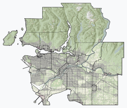
Burrard Inlet is a shallow-sided fjord in the northwestern Lower Mainland, British Columbia, Canada. Formed during the last Ice Age, it separates the City of Vancouver and the rest of the lowland Burrard Peninsula to the south from the coastal slopes of the North Shore Mountains, which span West Vancouver and the City and District of North Vancouver to the north.

Cypress Mountain is a ski area in West Vancouver, British Columbia, Canada, located in the southern section of Cypress Provincial Park, operated under a BC Parks Park Use Permit.

Mount Bishop is a mountain located on the northern border of Mount Seymour Provincial Park in the District of North Vancouver, British Columbia. It is a part of the North Shore Mountains, rising from the shores of Indian Arm to a summit of 1,509 metres (4,951 ft). Mount Bishop is a rocky summit with bluffs and old growth on its lower slopes.

The North Shore Mountains are a mountain range overlooking Vancouver in British Columbia, Canada. Their southernmost peaks are visible from most areas in Vancouver and form a distinctive backdrop for the city.

Sx̱ótsaqel/Chilliwack Lake Provincial Park is a provincial park in British Columbia, Canada. Covering 92.58 km2, the park is located 150 km east of Vancouver in the Chilliwack River Valley.

E.C. Manning Provincial Park is a provincial park in British Columbia, Canada. It is usually referred to as Manning Park, although that nomenclature is also used to refer to the resort and ski area at the park's core. The park covers 83,671 hectares (323 mi2) and was the second most visited provincial park in 2017-18 after Cypress Provincial Park. The park lies along British Columbia Highway 3, and occupies a large amount of land between Hope and Princeton along the Canada-United States border.

The Purcell Wilderness Conservancy is a provincial park in British Columbia, Canada. It was established in 1974, and encompasses six large drainages in the Purcell Mountains in the southeast of the province. It contains high peaks, alpine meadows and ridges, deep creek and river valleys, and hot springs at Dewar Creek.

Indian Arm is a steep-sided glacial fjord adjacent to the city of Vancouver in southwestern British Columbia. Formed during the last Ice Age, it extends due north from Burrard Inlet, between the communities of Belcarra and the District of North Vancouver, then on into mountainous wilderness. Burrard Inlet and the opening of Indian Arm was mapped by Captain George Vancouver and fully explored days later by Dionisio Alcalá Galiano in June 1792.

The Fannin Range is a small mountain range in the Pacific Ranges of the Coast Mountains of British Columbia, Canada. Lying between the Seymour River and the glacial fjord Indian Arm, the range extends from the slopes of Mount Seymour on the Burrard Inlet to the district of North Vancouver more than 34 km (21 mi) north to the headwaters of the Indian River. It is named after the naturalist John Fannin It is commonly considered to be part of the North Shore Mountains.

Buntzen Lake is a 4.8 kilometres (3 mi) long lake in Anmore, British Columbia, Canada, in the Greater Vancouver area. It is named after the first general manager of the B.C. Electric Co., Johannes Buntzen. There is a smaller lake just to the north named McCombe Lake.
Mount Rosseau is a mountain on Vancouver Island, British Columbia, Canada, located 43 km (27 mi) southwest of Courtenay and 23 km (14 mi) south of Mount Albert Edward. It is the highest summit of the Septimus-Rosseau massif. The most western summit of the massif is Mount Septimus.

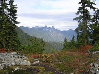
Mount Elsay is a mountain in southwestern British Columbia, Canada, located near the middle of Mount Seymour Provincial Park in the District of North Vancouver. It is a part of the North Shore Mountains, rising from the shores of Indian Arm to a summit of 1,419 m (4,656 ft). It is named after nearby Elsay Lake and Creek. These names are thought to derive from a Scottish settler, probably after a place name in Scotland.
The Seymour River is a river in the North Shuswap of British Columbia, Canada. It starts from the Monashee Mountains north of Shuswap Lake, and flows towards south into the northern end of the Seymour Arm of the lake.

Azure Lake is a fjord-like lake located in east-central British Columbia, Canada. It is an expansion of the Azure River which rises from an unnamed glacier in the Cariboo Mountains. The outflow is also called the Azure River, but it is only 50 m (164 ft) long before it flows into the Clearwater River. Azure Lake is one of the six major lakes in Wells Gray Provincial Park.

Wells Gray Provincial Park is a large wilderness park located in east-central British Columbia, Canada. The park protects most of the southern, and highest, regions of the Cariboo Mountains and covers 5,415 square kilometres. It is British Columbia's fifth largest provincial park, after Tweedsmuir, Tatshenshini, Spatsizi and Northern Rocky Mountains.
Lynn Headwaters Regional Park is an area of North Vancouver, British Columbia, and is the largest of twenty-three regional parks in Metro Vancouver. At 9,216.5 acres (3,729.8 ha), the park boasts a variety of trails for hikers, including easy, intermediate, and challenging. The trails are colour-coded and range from 3 kilometres (1.9 mi) to 21.4 kilometres (13.3 mi). Bikes and dogs are allowed on select trails.

Mount Seymour Provincial Park is a park in Vancouver, British Columbia's North Shore Mountains. With an area of 35 square kilometres, it is located approximately 15 kilometres north of Downtown Vancouver. The park, named after Frederick Seymour, was established in 1936. Mount Seymour Provincial Park provides visitors with a variety of recreational activities and animals with natural habitat.
Percy Creek is a stream in the southeastern part of the District of North Vancouver in the Lower Mainland part of British Columbia, Canada. It is in the Pacific Ocean drainage basin and is a right tributary of Indian Arm.