
Lincoln County is a county located in the U.S. state of Montana. As of the 2020 census, the population was 19,677. Its county seat is Libby. The county was founded in 1909 and named for President Abraham Lincoln. The county lies on Montana's north border and thus shares the US-Canadian border with the Canadian province of British Columbia.

Flathead County is in the U.S. state of Montana. At the 2020 census, its population was 104,357, making it the state's fourth most populous county. Its county seat is Kalispell. Its numerical designation is 7. Its northern border is on the state's north border, making it contiguous with the Canada–US border, facing British Columbia.
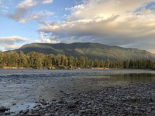
Columbia Falls is a city along the Flathead River in Flathead County, Montana, United States. The population was 5,308 at the 2020 census. Columbia Falls has been ranked as one of the best and safest places to live in Montana.

The Flathead Indian Reservation, located in western Montana on the Flathead River, is home to the Bitterroot Salish, Kootenai, and Pend d'Oreilles tribes – also known as the Confederated Salish and Kootenai Tribes of the Flathead Nation. The reservation was created through the July 16, 1855, Treaty of Hellgate.

The Clark Fork, or the Clark Fork of the Columbia River, is a river in the U.S. states of Montana and Idaho, approximately 310 miles (500 km) long. The largest river by volume in Montana, it drains an extensive region of the Rocky Mountains in western Montana and northern Idaho in the watershed of the Columbia River. The river flows northwest through a long valley at the base of the Cabinet Mountains and empties into Lake Pend Oreille in the Idaho Panhandle. The Pend Oreille River in Idaho, Washington, and British Columbia, Canada which drains the lake to the Columbia in Washington, is sometimes included as part of the Clark Fork, giving it a total length of 479 miles (771 km), with a drainage area of 25,820 square miles (66,900 km2). In its upper 20 miles (32 km) in Montana near Butte, it is known as Silver Bow Creek. Interstate 90 follows much of the upper course of the river from Butte to Saint Regis. The highest point within the river's watershed is Mount Evans at 10,641 feet (3,243 m) in Deer Lodge County, Montana along the Continental Divide.

The Pend Oreille River is a tributary of the Columbia River, approximately 130 miles (209 km) long, in northern Idaho and northeastern Washington in the United States, as well as southeastern British Columbia in Canada. In its passage through British Columbia its name is spelled Pend-d'Oreille River. It drains a scenic area of the Rocky Mountains along the U.S.-Canada border on the east side of the Columbia. The river is sometimes defined as the lower part of the Clark Fork, which rises in western Montana. The river drains an area of 66,800 square kilometres (25,792 sq mi), mostly through the Clark Fork and its tributaries in western Montana and including a portion of the Flathead River in southeastern British Columbia. The full drainage basin of the river and its tributaries accounts for 43% of the entire Columbia River Basin above the confluence with the Columbia. The total area of the Pend Oreille basin is just under 10% of the entire 258,000-square-mile (670,000 km2) Columbia Basin. Box Canyon Dam is currently underway on a multimillion-dollar project for a fish ladder.

The Kootenay River or Kootenai River is a major river of the Northwest Plateau in southeastern British Columbia, Canada, and northern Montana and Idaho in the United States. It is one of the uppermost major tributaries of the Columbia River, the largest North American river that empties into the Pacific Ocean. The Kootenay River runs 781 kilometres (485 mi) from its headwaters in the Kootenay Ranges of the Canadian Rockies, flowing from British Columbia's East Kootenay region into northwestern Montana, then west into the northernmost Idaho Panhandle and returning to British Columbia in the West Kootenay region, where it joins the Columbia at Castlegar.

Flathead Lake is a large natural lake in northwest Montana, United States.

The Flathead River, in the northwestern part of the U.S. state of Montana, originates in the Canadian Rockies to the north of Glacier National Park and flows southwest into Flathead Lake, then after a journey of 158 miles (254 km), empties into the Clark Fork. The river is part of the Columbia River drainage basin, as the Clark Fork is a tributary of the Pend Oreille River, a Columbia River tributary. With a drainage basin extending over 8,795 square miles (22,780 km2) and an average discharge of 11,380 cubic feet per second (322 m3/s), the Flathead is the largest tributary of the Clark Fork and constitutes over half of its flow.
Kokanee is a word from the Okanagan language referring to land-locked lake populations of sockeye salmon. It may also refer to:
The Flathead Valley is a region of the U.S. state located in the Northwestern Montana. It includes parts of Flathead County and Lake County. Notable communities include Kalispell, Bigfork, Whitefish, Columbia Falls, Polson, Ronan, and St. Ignatius. The geography of the Flathead roughly corresponds to the valley where Flathead Lake is located, with two distinct ends – the northern Flathead Valley and the southern (lower) Flathead Valley. In addition to Flathead and Whitefish lakes, the area's proximity to attractions such as Glacier National Park, Whitefish Mountain Resort, and Blacktail Mountain Ski Area have made the area a major summer and winter resort destination. Many outdoor activities can be pursued, including hiking, backpacking, boating, rafting, canoeing, skiing, hunting, and fly fishing. The lower Flathead Valley and the southern half of Flathead Lake are within the Flathead Indian Reservation and is home to the historic St. Ignatius Mission, founded in 1854.

The Montana Stream Access Law says that anglers, floaters and other recreationists in Montana have full use of most natural waterways between the high-water marks for fishing and floating, along with swimming and other river or stream-related activities. In 1984, the Montana Supreme Court held that the streambed of any river or stream that has the capability to be used for recreation can be accessed by the public regardless of whether the river is navigable or who owns the streambed property. On January 16, 2014, the Montana Supreme Court, in a lawsuit filed by the Public Land/Water Access Association over access via county bridges on the Ruby river in Madison County, Montana reaffirmed the Montana Stream Access Law and the public's right to access rivers in Montana from public easements.

The North Fork Flathead River is a 153-mile (246 km) river flowing through British Columbia, Canada, south into the U.S. state of Montana. It is one of the three primary forks of the Flathead River, the main inflow of Flathead Lake and a tributary of the Columbia River via the Clark Fork River and the Pend Oreille River. The river is sometimes considered the upper headwaters of the Flathead River, although the North Fork is its official name in the U.S. Other naming conventions for the river include Flathead River - North Fork, North Fork of Flathead River, and North Fork of the Flathead River.
Lost Coon Lake, is a lake south of Whitefish, Flathead County in the state of Montana, USA. This lake was once known to be home to a variety of fish and can be fished by fly rod or baitcasting. Alternate names for this lake include Lost Loon Lake.

West Shore State Park is a public recreation area occupying 129 acres on the western shore of Flathead Lake five miles south of Lakeside in Lake County, Montana. The state park offers boating, fishing, camping, swimming, hiking, and wildlife viewing.

Yellow Bay State Park is a public recreation area occupying fifteen acres (6.1 ha) on the eastern shore of Flathead Lake twelve miles (19 km) south of Bigfork in Lake County, Montana. The state park offers boating, fishing, camping, swimming, and wildlife viewing.
Tally Lake is a freshwater lake located in Flathead County, Montana in the northwestern region of the United States. The lake is about 20 miles west of the town of Whitefish. It is a popular lake for recreational activities including fishing, boating, swimming and cliff jumping, and hiking on the surrounding trails, and is notable for its great depth and unusual geology. The lake's surface area is over 1200 acres. The lake is located at roughly 3,500 feet above sea level. It is about 445 feet deep at its deepest point, making it the deepest lake in Montana and the deepest natural lake. Despite its large volume, the lake tends to be warm in late summer because its waters are darkly colored due to high levels of tannins. These cause the lake to absorb and retain more heat than comparatively clearer bodies of water in the region.


