100 Mile House is a district municipality located in the South Cariboo region of central British Columbia, Canada.
Highway 97 is a major highway in the Canadian province of British Columbia. It is the longest continuously numbered route in the province, running 2,081 km (1,293 mi) and is the only route that runs the entire north–south length of the British Columbia, connecting the Canada–United States border near Osoyoos in the south to the British Columbia–Yukon boundary in the north at Watson Lake, Yukon.
Highway 24, also known as the Little Fort Highway or the Interlakes Highway, is a 97-kilometre-long (60 mi) east-west connection between the Cariboo Highway, just south of 100 Mile House, and the Southern Yellowhead Highway at Little Fort. It practically provides a "second-chance" route to travellers heading east from Vancouver who missed the route to the northern part of the province or toward Edmonton.
Highway 26, also known as the Barkerville Highway, is a minor east-west highway in the North Cariboo region of the Central Interior of British Columbia, Canada. First opened in 1967, it provides access to the community of Wells and the famous gold rush town of Barkerville at the foot of the Cariboo Mountains, respectively 75 and 81 km east of the highway's junction with Highway 97 at Quesnel. Also accessed by the route is Bowron Lakes Provincial Park, a popular canoeing expedition circuit, the cutoff for which is between Barkerville and Wells. Since Highway 26 is very lightly travelled, it has not needed any major improvements since its opening. Its route is approximately the same as that of the Cariboo Wagon Road.

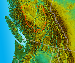
The Cariboo is an intermontane region of British Columbia, Canada, centered on a plateau stretching from Fraser Canyon to the Cariboo Mountains. The name is a reference to the caribou that were once abundant in the region.

Williams Lake is a city in the Central Interior of British Columbia, in the central part of a region known as the Cariboo. Williams Lake is one of the largest cites, by population of metropolitan area, in the Cariboo after neighbouring Quesnel. The city is famous for the Williams Lake Stampede, which was once the second largest professional rodeo in Canada, after only the Calgary Stampede.

The Cariboo Regional District spans the Cities and Districts of Quesnel, Williams Lake, 100 Mile House, and Wells in the Central Interior of British Columbia.

The Cariboo Road was a project initiated in 1860 by the Governor of the Colony of British Columbia, James Douglas. It involved a feat of engineering stretching from Fort Yale to Barkerville, B.C. through extremely hazardous canyon territory in the Interior of British Columbia.

The Cariboo Mountains are the northernmost subrange of the Columbia Mountains, which run down into the Spokane area of the United States and include the Selkirks, Monashees and Purcells. The Cariboo Mountains are entirely within the province of British Columbia, Canada. The range is 7,700 square kilometres (3,000 sq mi) in area and about 245 km in length (southeast–northwest) and about 90 km at its widest (southwest–northeast).

Clinton is a village in British Columbia, Canada, located approximately 40 km (25 mi) northwest of Cache Creek and 30 km south of 70 Mile House.
Soda Creek is a rural subdivision 38 km north of Williams Lake in British Columbia, Canada. Located on the east bank of the Fraser River, Soda Creek was originally the home of the Xat'sull First Nation. Soda Creek Indian Reserve No. 1 is located on the left (E) bank of the Fraser River, one mile south of the Soda Creek BCR (CN) station, 431.10 ha. 52°19′00″N122°16′00″W

The British Columbia Interior, popularly referred to as the BC Interior or simply the Interior, is a geographic region of the Canadian province of British Columbia. While the exact boundaries are variously defined, the British Columbia Interior is generally defined to include the 14 regional districts that do not have coastline along the Pacific Ocean or Salish Sea, and are not part of the Lower Mainland. Other boundaries may exclude parts of or even entire regional districts, or expand the definition to include the regional districts of Fraser Valley, Squamish–Lillooet, and Kitimat–Stikine.

The Shuswap Highland is a plateau-like hilly area of 14,511 km2 (5,603 sq mi) in British Columbia, Canada. It spans the upland area between the Bonaparte and Thompson Plateaus from the area of Mahood Lake, at the southeast corner of the Cariboo Plateau, southeast towards the lower Shuswap River east of Vernon in the Okanagan.
The Old Cariboo Road is a reference to the original wagon road to the Cariboo gold fields in what is now the Canadian province of British Columbia. It should not be confused with the Cariboo Road, which was built slightly later and used a different route.

The Charlotte sternwheeler was built in 1896 by Alexander Watson for the Northern British Columbia Navigation Company. The partners of the NBCNC were Stephen Tingley, Senator James Reid and John Irving. She was launched on August 3, 1896 and christened by James Reid's wife after whom she'd been named.
Williams Lake is a lake in the city of the same name in the Cariboo region of the Central Interior of British Columbia, Canada. Williams Lake Indian Reserve No. 1, a.k.a. "Sugarcane Reserve" is located around the east end of the lake. British Columbia provincial highway 97, the Cariboo Highway, runs along the lake's northern side.
Robert McLeese was an Irish-born hotel keeper, store owner, owner of a sternwheel river boat and political figure in British Columbia. He represented Cariboo in the Legislative Assembly of British Columbia from 1882 to 1888.
McLeese Lake is an unincorporated community on British Columbia Highway 97 in the Cariboo region of the Central Interior of British Columbia, Canada. It is named for the lake of the same name, which itself was named for Robert McLeese, a pioneer storekeeper, hotelier and steamboat owner and also politician.
McLeese, Mac Leese, or variant, may refer to:


