
The Rocky Mountains, also known as the Rockies, are a major mountain range and the largest mountain system in North America. The Rocky Mountains stretch 3,000 miles in straight-line distance from the northernmost part of western Canada, to New Mexico in the southwestern United States. Depending on differing definitions between Canada and the U.S., its northern terminus is located either in northern British Columbia's Terminal Range south of the Liard River and east of the Trench, or in the northeastern foothills of the Brooks Range/British Mountains that face the Beaufort Sea coasts between the Canning River and the Firth River across the Alaska-Yukon border. Its southernmost point is near the Albuquerque area adjacent to the Rio Grande rift and north of the Sandia–Manzano Mountain Range. Being the easternmost portion of the North American Cordillera, the Rockies are distinct from the tectonically younger Cascade Range and Sierra Nevada, which both lie farther to its west.

Yoho National Park is a national park of Canada. It is located within the Rocky Mountains along the western slope of the Continental Divide of the Americas in southeastern British Columbia, bordered by Kootenay National Park to the south and Banff National Park to the east in Alberta. The word Yoho is a Cree expression of amazement or awe, and it is an apt description for the park's spectacular landscape of massive ice fields and mountain peaks, which rank among the highest in the Canadian Rockies.

Field is an unincorporated community of approximately 169 people located in the Kicking Horse River valley of southeastern British Columbia, Canada, within the confines of Yoho National Park. At an elevation of 1,256 m (4,121 ft), it is 27 km (17 mi) west of Lake Louise along the Trans-Canada Highway, which provides the only road access to the town. The community is named for Cyrus West Field of Transatlantic telegraph cable fame, who visited the area in 1884.

Kootenay National Park is a national park of Canada in southeastern British Columbia. The park consists of 1,406 km2 (543 sq mi) of the Canadian Rockies, including parts of the Kootenay and Park mountain ranges, the Kootenay River and the entirety of the Vermilion River. While the Vermilion River is completely contained within the park, the Kootenay River has its headwaters just outside the park boundary, flowing through the park into the Rocky Mountain Trench and eventually joining the Columbia River. The park ranges in elevation from 918 m (3,012 ft) at the southwestern park entrance to 3,424 m (11,234 ft) at Deltaform Mountain.
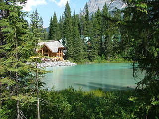
Emerald Lake is a freshwater lake located in Yoho National Park, British Columbia, Canada. Yoho National Park is one of the 4 contiguous National Parks in the heart of Canada's Rocky Mountains, along the boundary of British Columbia and Alberta Provinces, the other Parks are Kootenay, Jasper, and Banff.

Garibaldi Provincial Park, also called Garibaldi Park, is a wilderness park located on the coastal mainland of British Columbia, Canada, 70 kilometres (43.5 mi) north of Vancouver. It was established in 1920 and named a Class A Provincial Park of British Columbia in 1927. The park is a popular destination for outdoor recreation, with over 30,000 overnight campers and over 106,000 day users in the 2017/2018 season.

Hamber Provincial Park is a provincial park in British Columbia, Canada, located 130 kilometres (80.7 mi) north of Golden. Straddling the Great Divide on the provincial boundary with Alberta, the park is surrounded on three sides by Jasper National Park and protects the headwaters of the Wood River at Fortress Lake.
Norbury Lake Provincial Park is a 97-hectare (240-acre) provincial park in British Columbia, Canada.
The Stanley Mitchell hut is an alpine hut located at an altitude of 2,060 metres (6,759 ft) in the Little Yoho Valley in Yoho National Park, British Columbia, Canada. It sits in a small meadow not far from the base of a mountain called The President. It serves as a base for hiking, scrambling, ski-touring and climbing the nearby mountains. The hut is maintained by the Alpine Club of Canada.
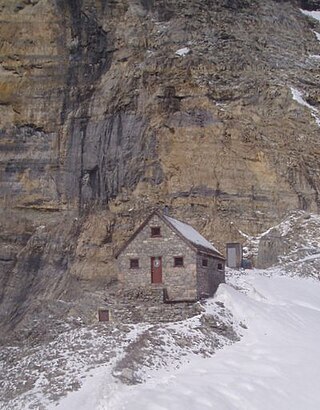
The Abbot Pass hut was an alpine hut located at an altitude of 2,925 metres (9,596 ft) in Abbot Pass in the Rocky Mountains in Alberta, Canada. It was nestled between Mount Victoria and Mount Lefroy, straddling the Great Divide, which, in this region, defines the boundary between Banff National Park in Alberta and Yoho National Park in British Columbia. While close to the border, the hut lay entirely in Banff National Park, and was the second-highest permanently habitable structure in Canada. The hut was maintained by the Alpine Club of Canada.

Lake O'Hara is a lake at an elevation of 2,020 metres (6,630 ft) in the alpine area of Yoho National Park, in the province of British Columbia, on the western side of the Great Divide with the province of Alberta and Banff National Park to the east. The lake and the valley are accessible through a bus service that is run by Parks Canada or by an 11 km hike along a road with an elevation gain of approximately 500m.
Opabin Lake is a body of water located at an elevation of 2,277 metres (7,470 ft) in the mountains of Yoho National Park, near Field, British Columbia, Canada.

Thomas Edmonds Wilson was a Canadian outfitter and guide.

Mount Biddle is a mountain in British Columbia, Canada.
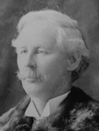
James Joseph McArthur was a Canadian surveyor and mountaineer who was the first to climb several peaks in the Canadian Rocky Mountains. Two mountains and a lake are named after him, and he gave names to various other features. He was a pioneer in the use of photography for surveying, under the direction of the Surveyor General, Édouard-Gaston Deville. He did extensive work on surveying the borders between Canada and the United States in the Yukon and west of Lake Superior.

Paget Peak is a mountain in Yoho National Park, British Columbia, Canada. It is readily accessible via a hiking trail.
Odaray Mountain is a 3,137-metre (10,292-foot) summit located west of Lake O'Hara in the Bow Range of Yoho National Park, in the Canadian Rockies of British Columbia, Canada. Its nearest higher peak is Mount Huber, 3.86 km (2.40 mi) to the east. The standard climbing route follows the southeast glacier and ridge starting from Elizabeth Parker hut. Pronunciation sounds like the two words "ode array".
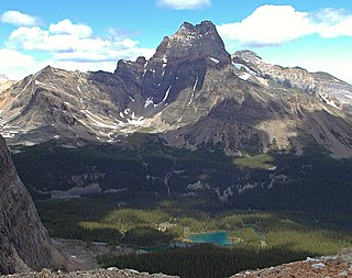
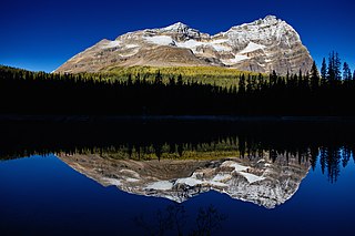
Cathedral Mountain is a 3,189-metre (10,463-foot) complex massif located six kilometres northwest of Lake O'Hara in Yoho National Park, in the Canadian Rockies of British Columbia, Canada. Its shape and structure conjures up a resemblance to a gothic cathedral that has inspired many artists, including Group of Seven's Arthur Lismer, to paint it back in 1928. This picturesque mountain is visible from Highway 1, the Trans-Canada Highway, near Kicking Horse Pass. Its nearest higher peak is Mount Stephen, 3.0 km (1.9 mi) to the west. To prevent damage to its operations, the Canadian Pacific Railway pumps overflow from Teacup Lake down the west face of Cathedral to minimize the subglacial lake's discharging in a phenomenon known as a jökulhlaup.

Mount Schaffer is a 2,691-metre (8,829-foot) mountain summit located one kilometre (0.62 mi) southwest of Lake O'Hara in Yoho National Park, in the Bow Range of the Canadian Rockies of British Columbia, Canada. Its nearest higher peak is Mount Biddle, 3.2 km (2.0 mi) to the southeast. Mount Schaffer is situated 3.5 kilometres (2.2 mi) west of the Continental Divide, and 12 kilometres (7.5 mi) southeast of Field, British Columbia.

Park Mountain is a 2,951-metre (9,682-foot) mountain summit located above the southwest shore of Lake McArthur in Yoho National Park, in the Bow Range of the Canadian Rockies of British Columbia, Canada. Its nearest higher peak is Mount Biddle, 3.0 km (1.9 mi) to the east. Park Mountain is situated four kilometres west of the Continental Divide, and 12 km (7.5 mi) southeast of Field, British Columbia.

