
The Thompson River is the largest tributary of the Fraser River, flowing through the south-central portion of British Columbia, Canada. The Thompson River has two main branches, the South Thompson River and the North Thompson River. The river is home to several varieties of Pacific salmon and trout. The area's geological history was heavily influenced by glaciation, and the several large glacial lakes have filled the river valley over the last 12,000 years. Archaeological evidence shows human habitation in the watershed dating back at least 8,300 years. The Thompson was named by Fraser River explorer, Simon Fraser, in honour of his friend, Columbia Basin explorer David Thompson. Recreational use of the river includes whitewater rafting and angling.
Dease Lake is a small community in the Cassiar Country of the Northern Interior of British Columbia, Canada. It is 230 km south of the Yukon border on Stewart–Cassiar Highway at the south end of the lake of the same name. Dease Lake is the last major centre before the Alaska Highway while driving northbound, and also the junction to Telegraph Creek and the Grand Canyon of the Stikine. Dease Lake Indian Reserve No. 9 is nearby and is under the governance of the Tahltan First Nation band government.

Barriere is a district municipality in central British Columbia, Canada, located 66 km (41 mi) north of the larger city of Kamloops on Highway 5. It is situated at the confluence of the Barrière River and North Thompson Rivers in the Central North Thompson Valley.
North Thompson Oxbows East Provincial Park is a provincial park in Thompson-Nicola Regional District in the Interior region of British Columbia, Canada. The park was established on April 30, 1996, and has an area of 288 hectares. The park protects a productive area of the North Thompson River lowlands that has high species diversity. There are patches of old-growth forest containing hybrid white spruce and subalpine fir. There are no camping or day-use facilities.
North Thompson Oxbows Jensen Island Provincial Park is a provincial park in Thompson-Nicola Regional District in the Interior region of British Columbia, Canada, about 20 kilometres (12 mi) north of Kamloops at the community of Heffley Creek. The park was established on April 30, 1996, and has an area of 30 hectares. It protects the riparian habitat of a single, seasonal oxbow on the right bank of the North Thompson River. There are no camping or day-use facilities.
North Thompson Oxbows Manteau Provincial Park is a provincial park in Thompson-Nicola Regional District in the Interior region of British Columbia, Canada. The park was established on April 30, 1996, and has an area of 515 hectares. It protects "…floodplain wetlands, numerous oxbow lakes, sandbars, back channels, levees, along the glacier-fed North Thompson River." There are no camping or day-use facilities.

The North Thompson River is the northern branch of the Thompson River, the largest tributary of the Fraser River, in the Canadian province of British Columbia. It originates at the toe of the Thompson Glacier in the Premier Range of the Cariboo Mountains, west of the community of Valemount. The river flows generally south through the Shuswap Highland towards Kamloops where it joins the South Thompson River to form the main stem Thompson River.

The Salmon Glacier is a glacier located ~25 km (16 mi) north of Stewart, British Columbia, and Hyder, Alaska, just on the Canadian side of the border. The glacier, one of hundreds in the Boundary Ranges, is notable for its major potential as a natural hazard. Summit Lake is located at the northern end of the glacier and every year around mid-July the lake breaks an ice-dam and then flows under the Salmon Glacier into the Salmon River. This causes the river to rise approximately 4–5 ft (1.2–1.5 m) for several days.
Major-General Arthur Reid Lempriere was a British Army officer of the Royal Engineers, including of the Royal Engineers, Columbia Detachment that founded British Columbia as the Colony of British Columbia (1858–1866).
The Simpcw First Nation, formerly known as the North Thompson Indian Band, is a First Nations band government based in the Thompson Country of British Columbia, Canada. It is a member of the Shuswap Nation Tribal Council. It is a First Nations government of the Secwepemc (Shuswap) Nation, located in the Central Interior region of the Canadian province of British Columbia. The band's main community is at Chu Chua, British Columbia. Four of the five First Nation Reserves in Simpcw territory were designated on July 5, 1877 and the fifth was designated on February 24, 1916. The Shuswap language name for North Thompson Band's community and reserve is 'Simpcw'.
The Indian River is a river in the Lower Mainland region of British Columbia, Canada. It is in the Pacific Ocean drainage basin, and is a tributary of Indian Arm.
Scum Lake is a lake in the Chilcotin region of the Interior of British Columbia, Canada.
Percy Creek is a stream in the southeastern part of the District of North Vancouver in the Lower Mainland part of British Columbia, Canada. It is in the Pacific Ocean drainage basin and is a right tributary of Indian Arm.
Moonbeam Creek is a stream in Thompson-Nicola Regional District in the Interior region of British Columbia, Canada. It is in the Pacific Ocean drainage basin and is a left tributary of the North Thompson River. The nearest communities to the mouth of the creek on British Columbia Highway 5 are Blue River 40 kilometres (25 mi) south and Valemount 50 kilometres (31 mi) north; the mouth of the creek is just downstream of confluence of the North Thompson River and the Albreda River, where the North Thompson River turns 90° right and heads south.
The Albreda River is a river in Thompson-Nicola Regional District and the Regional District of Fraser-Fort George in the Interior region of British Columbia, Canada. It is in the Pacific Ocean drainage basin and is a left tributary of the North Thompson River. The nearest communities to the mouth of the creek on British Columbia Highway 5 are Blue River 42 kilometres (26 mi) south and Valemount 48 kilometres (30 mi) north; the mouth of the river is at a point where the North Thompson River, arriving downstream from its source, turns 90° right and heads south.
Canvas Creek is a stream in Kamloops Division Yale Land District in the Interior region of British Columbia, Canada. It is in the Pacific Ocean drainage basin and is a right tributary of the North Thompson River.

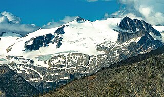
Mount Albreda is a mountain located in British Columbia, Canada.
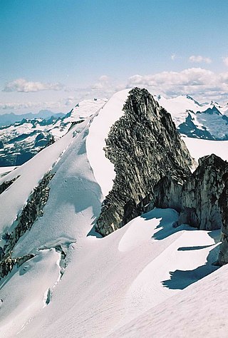
Isosceles Peak is a 2,488-metre (8,163-foot) mountain summit located in British Columbia, Canada.
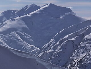
Parapet Peak is a 2,463-metre (8,081-foot) mountain summit located in British Columbia, Canada.
Kwoiek Peak is a 2,736-metre (8,976-foot) mountain summit located in British Columbia, Canada.

