The Jacques-Cartier River is a river in the province of Quebec, Canada. It is 161 km long and its source is Jacques-Cartier Lake in Laurentides Wildlife Reserve, and flows in a predominantly southern direction before ending in the Saint Lawrence River at Donnacona, about 30 km upstream from Quebec City.

The Batiscan River is located in Mauricie administrative region, in Province of Quebec, Canada. This river flows 196 kilometres (122 mi) from Lake Édouard in Mauricie south and west to empty into the St. Lawrence River at Batiscan, northeast of Trois-Rivières, Quebec. It passes through the regional county municipalities (RCM) of La Tuque, Portneuf, Mékinac and Les Chenaux.

The Montmorency River is a tributary of North-East bank of St. Lawrence river, flowing in the administrative region of Capitale-Nationale, in the province of Quebec, Canada. The course of the river successively crosses the regional county municipality of:
Batiscanie is the watershed of the Batiscan River, located in the center of the province of Quebec, Canada, covering 4690 km² on the North Shore of the St. Lawrence River. The area covered by Batiscanie is 53% in the administrative région of Mauricie and 47% in the administrative region of the Capitale-Nationale.

The Noire River flows in the municipality of rivière-à-Pierre, Saint-Alban and Saint-Casimir, in the Portneuf Regional County Municipality, in the administrative region of Capitale-Nationale, in Quebec, in Canada.

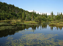
The Lac de la Galette is a freshwater body of the town of La Tuque, in Haute-Mauricie, forming a bay on the south shore of Gouin Reservoir and west of the upper Saint-Maurice River, in the administrative region of Mauricie, in the province of Quebec, in Canada.
The De La Galette River is a tributary of the southern shore of Gouin Reservoir, flowing into the territory of the town of La Tuque, in the administrative region of the Mauricie, in Quebec, in Canada.

The Sautauriski River is a tributary of the Jacques-Cartier River, flowing in the administrative region of Capitale-Nationale, in Quebec, Canada. This watercourse subsequently crosses:
The Rivière à l'Épaule is a tributary of the Jacques-Cartier River, flowing in the administrative region of Capitale-Nationale, in Quebec, Canada. The course of the river crosses the unorganized territory of Lac-Jacques-Cartier in the La Côte-de-Beaupré Regional County Municipality, as well as the township municipality unis de Stoneham-et-Tewkesbury, located in the MRC La Jacques-Cartier Regional County Municipality.
The Cassian River is a tributary of the Jacques-Cartier River, flowing in the municipalities of Saint-Gabriel-de-Valcartier and Stoneham-et-Tewkesbury, in the La Jacques-Cartier Regional County Municipality, in the administrative region of Capitale-Nationale, in Quebec, Canada.

The Rivière Cachée is a tributary of the Jacques-Cartier River, flowing in the administrative region of Capitale-Nationale, in Quebec, Canada. The course of the river crosses the unorganized territory of Lac-Jacques-Cartier in the La Côte-de-Beaupré Regional County Municipality, as well as the township municipality unis de Stoneham-et-Tewkesbury, located in the MRC La Jacques-Cartier Regional County Municipality.

The Nelson River is located in the administrative region of Capitale-Nationale, in province of Quebec, in Canada. It is part of the watershed of the Saint-Charles River. The course of this river crosses:
The Jaune River is a tributary of the Saint-Charles River flowing in the administrative region of Capitale-Nationale, in the province of Quebec, Canada. The course of the river crosses:
The rivière des Sept Ponts is a tributary of the rivière du Berger flowing in the sectors of Beauport and Charlesbourg, in Quebec City, Quebec, Canada.
The Lac des Roches is a freshwater body of the city of Quebec, in the region of the Capitale-Nationale, in the province of Quebec, in Canada.

The rivière des Hurons is a river flowing in the heart of the municipality of Cantons-unis de Stoneham-et-Tewkesbury, located north of Quebec (city), in the La Jacques-Cartier Regional County Municipality, in the administrative region of Capitale-Nationale, in province from Quebec, to Canada.
The Turgeon River is a river flowing through the municipality of the United Townships of Stoneham-et-Tewkesbury, located north of the Quebec (city), in the La Jacques-Cartier Regional County Municipality, in the administrative region of Capitale-Nationale, in the province from Quebec, to Canada.
The rivière Noire is a tributary of the rivière des Hurons, flowing in the heart of the municipality of the townships of Stoneham-et-Tewkesbury, located north of the city of Quebec, in the La Jacques-Cartier Regional County Municipality, in the administrative region of the Capitale-Nationale, in the province of Quebec, in Canada.
La Petite Rivière is a tributary stream of the Nelson River, flowing in the administrative region of Capitale-Nationale, in the province from Quebec, to Canada. The course of the river crosses:
The Rivière à l'Île is a tributary of the west bank of the Montmorency River, flowing in the administrative region of Capitale-Nationale, Quebec, Canada. This river successively flows through the regional county municipalities (MRC) of:
- La Côte-de-Beaupré Regional County Municipality: municipality of Château-Richer;
- La Jacques-Cartier Regional County Municipality: the municipality of the united cantons of Stoneham-et-Tewkesbury and the city of Sainte-Brigitte-de-Laval.