
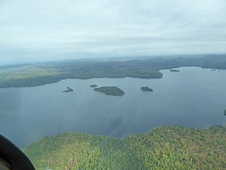
La Mauricie National Park is a national park located near Shawinigan in the Laurentian mountains, in the Mauricie region of Quebec, Canada. It covers 536 km2 (207 sq mi) in the southern Canadian Shield region bordering the Saint Lawrence lowlands. The park contains 150 lakes and many ponds.
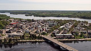
Shawinigan is a city located on the Saint-Maurice River in the Mauricie area in Quebec, Canada. It had a population of 49,620 as of the 2021 Canadian census.

The Saint-Maurice River flows north to south in central Quebec from Gouin Reservoir to empty into the Saint Lawrence River at Trois-Rivières, in the province of Quebec, in Canada. From its source at Gouin Reservoir, located at the same latitude as the Lac Saint-Jean, the river has a total drop of about 405 metres (1,329 ft), to finally reach the St. Lawrence river at Trois-Rivières. The river is 563 km long and has a drainage basin of 43,300 square kilometres (16,700 sq mi). Saint-Maurice River is one of the most important tributaries of the St. Lawrence River.
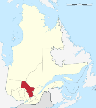
Mauricie is a traditional and current administrative region of Quebec. La Mauricie National Park is contained within the region, making tourism in Mauricie popular. The region has a land area of 35,860.05 km² and a population of 266,112 residents as of the 2016 Census. Its largest cities are Trois-Rivières and Shawinigan.

Route 155 is a north/south highway on the north shore of the Saint Lawrence River in Quebec, Canada. Its northern terminus is in Chambord at the junction of Route 169, and the southern terminus is the Piles Bridge in Shawinigan. Previously the highway continued to Autoroute 20 but that section was decommissioned in 2006 when Autoroute 55 was completed.

Shawinigan-Sud is a predominantly French-speaking settlement in the Mauricie area in Quebec, Canada, on the Saint-Maurice River. In 1996, its population was 11,804.

Lac-Normand is an unorganized territory in the Mauricie region of Quebec, Canada, part of the Mékinac Regional County Municipality.
The Radnor Township is located in the administrative region of Mauricie, in the province of Quebec, in Canada. Today, the administration of this territory is under the city of Shawinigan and Mekinac Regional County Municipality (RCM). Rectangular, the Canton is about 5 km wide and 38 km deep, oriented northwest to southeast. The central part of the township is in La Mauricie National Park, on the west bank of the Saint-Maurice River which cut diagonally this township. The southeastern part of the township includes the municipalities of Saint-Jean-des-Piles, Grandes-Piles, Saint-Roch-de-Mékinac, sector Lac-à-la-Tortue and Garneau railway junction.
The Mékinac Dam was built between 2010-2011 on the Mékinac River, creating Mékinac Lake in the municipality of Trois-Rives, in the Mékinac Regional County Municipality (RCM) in administrative region of Mauricie, in the province of Quebec, in Canada.

The Matawin River is a 161-kilometre (100 mi) river, flowing from west to east through the administrative regions of Lanaudière and Mauricie, in Quebec, Canada.
The Wayagamac Lake is located in the city of La Tuque in La Tuque, in Mauricie, in Quebec, in Canada. Until 2006, the territory of the lake was part of the former unorganized territory of Petit-Lac-Wayagamac, before being merged to the La Tuque. The area of the lake is administered by the Zec de la Bessonne.
The lac du Fou is located in the municipality of Saint-Roch-de-Mékinac, in La Mauricie National Park, in the region Mauricie, in Quebec, in Canada. Located west of the Saint-Maurice River, this lake is surrounded by forest and is mainly used for outdoor activities by visitors of La Mauricie National Park.
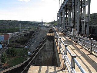
La Trenche Generating Station is a hydroelectric power plant on the Saint-Maurice River and within La Tuque, in Upper-Mauricie, in the administrative region of Mauricie, in Quebec, in Canada. Its construction was completed in 1950. This power station was put into service immediately. It is the central sixth to block the river from its mouth. With its 302 megawatts (405,000 hp), it is the most powerful. Hydro-Québec acquired La Trenche power from the Shawinigan Water & Power Company.

The rivière Shawinigan flows in the rural area to the north of Shawinigan, then through the town of Shawinigan, in Mauricie, in Quebec, in Canada. The Shawinigan is a tributary of the right bank of the Saint-Maurice.
The Cinconsine Lake is located on the west bank of the Saint-Maurice River in the territory of La Tuque, in Mauricie, in Quebec, in Canada. The area surrounding the lake is part of the northern part of the Zec Wessonneau.
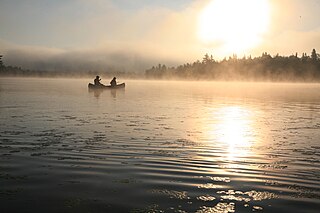
Mauricie tourism represents an important sector of Québec’s economy with 1.2 to 1.5 million visitors each year who spend 200 to 300 million dollars per year in tourist attractions and services. In 2011, 90% of tourists in Mauricie were Quebecers, 3% came from other Canadian provenances, 2% from the United States, and 4% from others.

The Yamachiche River is a river located on the north shore of Lake Saint-Pierre in the Maskinongé Regional County Municipality, in the administrative region of Mauricie, in Quebec, in Canada. It originates in the Mastigouche Wildlife Reserve.

The Mégiscane River is a tributary of Parent Lake (Abitibi). It flows in the Northwest of Quebec, in Canada, in the administrative regions of:

The Kikendatch Bay is a freshwater body that leads to the Gouin Reservoir, in the territory of La Tuque, in Haute-Mauricie, in the administrative region of Mauricie, in the province of Quebec, in Canada.

The Rivière Cachée is a tributary of the Saint-Maurice River, flowing on the north bank of the Saint Lawrence River, entirely in the town of Notre-Dame-du-Mont-Carmel, in the Les Chenaux Regional County Municipality, in the administrative region of Mauricie, in the province of Quebec, in Canada.

