
Lake Athabasca is in the north-west corner of Saskatchewan and the north-east corner of Alberta between 58° and 60° N in Canada. The lake is 26% in Alberta and 74% in Saskatchewan.

The Churchill River is a major river in Alberta, Saskatchewan and Manitoba, Canada. From the head of the Churchill Lake it is 1,609 kilometres (1,000 mi) long. It was named after John Churchill, 1st Duke of Marlborough and governor of the Hudson's Bay Company from 1685 to 1691. The Cree name for the river is Missinipi, meaning "big waters". The Denesuline name for the river is des nëdhë́, meaning "Great River".
The Clearwater River is located in the Canadian provinces of Saskatchewan and Alberta. It rises in the northern forest region of north-western Saskatchewan and joins the Athabasca River in north-eastern Alberta. It was part of an important trade route during the fur trade era and has been designated as a Canadian Heritage River.
Primrose Lake is a large lake in the Canadian provinces of Saskatchewan and Alberta in the Churchill River drainage basin. The lake straddles the Saskatchewan / Alberta border, with most of the water surface in Saskatchewan with only the south-west corner of the lake in Alberta. On the Saskatchewan side of the lake is Backes Island Wildlife Refuge, which is a small protected island near the middle of the lake that is important to birds. The entire lake plus surrounding land totalling 1,259.52 km2 (486.30 sq mi) is part of an Important Bird Area (IBA) of Canada.
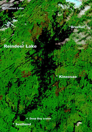
Reindeer Lake is a large lake in Western Canada located on the border between north-eastern Saskatchewan and north-western Manitoba, with the majority in Saskatchewan. The name of the lake appears to be a translation of the Algonquian name. It is the 24th largest lake in the world by area, as well as being the second-largest lake in Saskatchewan and the ninth largest in Canada. Eight percent of the lake lies in Manitoba while 92% of the lake is in Saskatchewan.

The Red Deer River is a river in Alberta and a small portion of Saskatchewan, Canada. It is a major tributary of the South Saskatchewan River and is part of the larger Saskatchewan / Nelson system that empties into Hudson Bay.

Beaver River is a large river in east-central Alberta and central Saskatchewan, Canada. It flows east through Alberta and Saskatchewan and then turns sharply north to flow into Lac Île-à-la-Crosse on the Churchill River which flows into Hudson Bay.

Wollaston Lake is a lake in the north-eastern part of the Canadian province of Saskatchewan. It is about 550 kilometres (340 mi) north-east of Prince Albert. With a surface area of 2,286 square kilometres (883 sq mi), it is the largest bifurcation lake in the world — that is, a lake that drains naturally in two directions.

Otter Lake is a lake in the province of Saskatchewan, Canada. It is located 80 kilometres (50 mi) north of La Ronge and is accessible from Highway 102. The lake is part of the Churchill River system. The Churchill River runs through the lake. It is approximately 10 miles long and 9 miles at its widest point.

Cree Lake is a lake in the Canadian province of Saskatchewan. The lake is the fourth largest in the province and is located west of Reindeer Lake and south of Lake Athabasca. There is no highway access, but the lake is reachable by float plane.
Lac la Ronge is a glacial lake in the Canadian province of Saskatchewan. It is the fifth largest lake in the province and is approximately 250 kilometres (160 mi) north of Prince Albert, on the edge of the Canadian Shield. La Ronge, Air Ronge, and the Lac La Ronge First Nation are on the western shore. The lake is a popular vacation spot. Recreational activities include fishing, boating, canoeing, hiking, and camping.

Peter Pond Lake is a glacial lake in the north-western part of the Canadian province of Saskatchewan. It is located in the boreal orest and Canadian Shield within the Churchill River drainage basin.

Amisk Lake is a lake in the east-central part of the Canadian province of Saskatchewan, about 22 kilometres (14 mi) south-west of Flin Flon, Manitoba. 'Amisk' means beaver in Cree. Along the lake's shores is the community of Denare Beach, a provincial recreation site with lake access and camping, and prehistoric limestone crevices. Access to the lake and its amenities is from Highway 167. Amisk Lake was on an important fur trade route in the 18th century.

Churchill Lake is a glacial lake in the north-west part of the Canadian province of Saskatchewan. Frobisher Lake flows in from the north while Peter Pond Lake flows in from the east through the Kisis Channel. Highway 155 crosses this channel at the village of Buffalo Narrows.
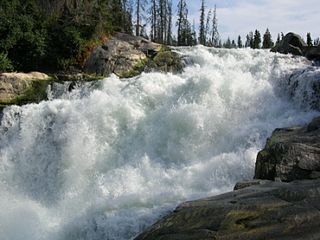
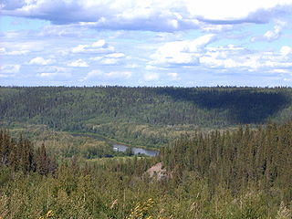
Rapid River is a short river in central Saskatchewan, Canada, about 13 kilometres (8 mi) east of the community of Stanley Mission. It is part of the Churchill River drainage basin. The river is about 1,000 metres (3,281 ft) long and flows north from Iskwatikan Lake, which lies downstream from Lac la Ronge, over the Nistowiak Falls, one of the tallest in Saskatchewan, and the Fisher Rapids, to Nistowiak Lake on the Churchill River, which flows to Hudson Bay. The entire river is within Lac La Ronge Provincial Park. At the mouth of the river, on Nistowiak Lake, is the Stanley 157A Indian reserve.

Lac La Loche is a lake in north west Saskatchewan near the Alberta border. The lake is part of the Churchill River system that flows into the Hudson Bay. The La Loche River at the southern end flows into Peter Pond Lake which is connected to Churchill Lake.
Turnor Lake is a lake in northern Saskatchewan, Canada. It is part of a series of connected lakes that flow into the Churchill River drainage system. These lakes from north to south are Wasekamio Lake, Turnor Lake, Frobisher Lake and Churchill Lake. The community of Turnor Lake which includes the Birch Narrows Dene Nation is located on the southern shore of Turnor Lake. It is accessed by Highway 909 off of Highway 155
Wasekamio Lake is a glacial lake in northern part of the Canadian province of Saskatchewan. It is part of a series of connected lakes that flow south into the Churchill River drainage system. These lakes from north to south are Wasekamio Lake, Turnor Lake, Frobisher Lake, and Churchill Lake. Just north of Wasekamio Lake is the Clearwater River that flows west to the Athabasca River.

Lac La Ronge Provincial Park is located in the boreal forest of the north central part of the Canadian province of Saskatchewan within the Canadian Shield. Situated in the Churchill River system, this provincial park has close to 100 lakes and more than 30 canoe routes, many of which follow old fur trade routes. Summer activities include camping, hiking, boating, fishing, and swimming. In the winter, there's cross-country skiing, snowmobiling, and ice fishing. Saskatchewan's highest waterfall is in the park. Nistowiak Falls are located north of Lac La Ronge along the Rapid River.
Lac Île-à-la-Crosse is a Y-shaped lake in the north-central region of the Canadian province of Saskatchewan along the course of the Churchill River. At the centre of the "Y" is the town of Île-à-la-Crosse, the second oldest town in Saskatchewan. Situated at the confluence of the Churchill and Beaver Rivers, the lake was an important fur trading centre in the 18th and 19th centuries. The lake, and the community of Île-à-la-Crosse, are named after the game of Lacrosse as French voyageurs had witnessed local Indians playing the game on an island in the lake.

