
The South Saskatchewan River is a major river in the Canadian provinces of Alberta and Saskatchewan. The river begins at the confluence of the Bow and Oldman Rivers in southern Alberta and ends at the Saskatchewan River Forks in central Saskatchewan. The Saskatchewan River Forks is the confluence of the South and North Saskatchewan Rivers and is the beginning of the Saskatchewan River.
Primrose Lake is a large lake in the Canadian provinces of Saskatchewan and Alberta in the Churchill River drainage basin. The lake straddles the Saskatchewan / Alberta border, with most of the water surface in Saskatchewan with only the south-west corner of the lake in Alberta. On the Saskatchewan side of the lake is Backes Island Wildlife Refuge, which is a small protected island near the middle of the lake that is important to birds. The entire lake plus surrounding land totalling 1,259.52 km2 (486.30 sq mi) is part of an Important Bird Area (IBA) of Canada.
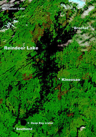
Reindeer Lake is a large lake in Western Canada located on the border between north-eastern Saskatchewan and north-western Manitoba, with the majority in Saskatchewan. The name of the lake appears to be a translation of the Algonquian name. It is the 24th largest lake in the world by area, as well as being the second-largest lake in Saskatchewan and the ninth largest in Canada. Eight percent of the lake lies in Manitoba while 92% of the lake is in Saskatchewan.
Emma Lake is a recreational lake in the Canadian province of Saskatchewan. It is located near the southern limit of the boreal forest, about 45 kilometres (28 mi) north of Prince Albert. The lake is within the District of Lakeland No. 521 and east of Prince Albert National Park. There are several small communities and recreational opportunities around Emma Lake and much of the northern half is within Great Blue Heron Provincial Park. Access to the lakes is from Highways 953, 952, and 263.

The Rural Municipality of Lumsden No. 189 is a rural municipality (RM) in the Canadian province of Saskatchewan within Census Division No. 6 and SARM Division No. 2. It is located in the south-east portion of the province.

Carrot River is a river in Western Canada in the north-eastern part Saskatchewan and the north-western part of Manitoba. The outlet of Wakaw Lake in Saskatchewan marks the beginning of the Carrot River and, from there, it flows north-east past several communities and Indian reserves until it joins the Saskatchewan River in the Cumberland Delta in Manitoba. The river's mouth is west and upstream of the Pasquia River and The Pas on the Saskatchewan River.

Duck Mountain Provincial Park is a provincial park, located in the Canadian province of Saskatchewan 14 kilometres (8.7 mi) east of the town of Kamsack and stretches about 12 kilometres (7.5 mi) eastward to the Saskatchewan / Manitoba boundary. The park covers approximately 150 km2 (58 sq mi). Road access to the park is via Highway 57, which connects Saskatchewan Highway 5 to Manitoba Highway 83.
Deschambault Lake is a freshwater lake in the north-eastern region of the Canadian province of Saskatchewan. The identically-named community of Deschambault Lake resides on its shore. There are also four Indian reserves on the lake — Kimosom Pwatinahk 203, Mistik Reserve, Pisiwiminiwatim 207, and Muskwaminiwatim 225 — and a provincial recreation site.

The Rural Municipality of Foam Lake No. 276 is a rural municipality (RM) in the Canadian province of Saskatchewan within Census Division No. 10 and SARM Division No. 4. It is located in the east-central portion of the province.
Fishing Lake is a closed basin freshwater lake in the Canadian province of Saskatchewan. The lake is 22 kilometres (14 mi) north of the town of Foam Lake, and 24 kilometres (15 mi) east of the town of Wadena and is accessed from Highways 5 and 310. The northern and eastern shore is in the RM of Sasman No. 336 and the southern and western shore is in the RM of Foam Lake No. 276. The north-east portion of the lake–on the east side of McCormick Bay–is designated as Fishing Lake Wildlife Refuge.

Lac la Ronge is a glacial lake in the Canadian province of Saskatchewan. It is the fifth largest lake in the province and is approximately 250 kilometres (160 mi) north of Prince Albert, on the edge of the Canadian Shield. La Ronge, Air Ronge, and the Lac La Ronge First Nation are on the western shore. The lake is a popular vacation spot. Recreational activities include fishing, boating, canoeing, hiking, and camping.

Doré Lake is a lake in the Canadian province of Saskatchewan in the basin of the Beaver River. Doré is the French Canadian term for 'walleye'. The lake is north-west of Smoothstone Lake and the Waskesiu Upland in the Mid-Boreal Upland ecozone of Canada and is surrounded by boreal forests. Saskatoon, Saskatchewan's largest city, is about 328 kilometres (204 mi) to the south. The northern village of Dore Lake is located on South Bay and is accessed from Highway 924 and Dore Lake Airport.

Tobin Lake is a reservoir along the course of the Saskatchewan River in the Canadian province of Saskatchewan. Tobin Lake was formed by the building of the E.B. Campbell Dam on the Saskatchewan River in 1963. Tobin Lake is named for William Thorburn, who was a fur trader on the Saskatchewan River. He had built a trading post on the Saskatchewan River where it is met by the Petaigan River. The rapids near the post became known as the "Thornburn Rapids". The name was later shortened to "Tobin Rapids".
Descharme Lake is a northern settlement on Descharme Lake in the boreal forest of northwest Saskatchewan. A 10-kilometre (6.2 mi) access road leads west to the community from the Saskatchewan Highway 955 turn-off 87 km north of La Loche. The northern settlement is an unincorporated community in the Northern Saskatchewan Administration District.

Sturgeon River is a river in the Hudson Bay drainage basin in the central part of the Canadian province of Saskatchewan. It flows from its source in the Waskesiu Hills in Prince Albert National Park to the North Saskatchewan River, just west of the city of Prince Albert.

Thunder Creek is a river in the Canadian province of Saskatchewan. The watershed of Thunder Creek is within the semi-arid Palliser's Triangle in south-central Saskatchewan. It begins at small, man-made reservoir near Lake Diefenbaker and flows in a south-easterly direction towards the city of Moose Jaw and the Moose Jaw River. The Moose Jaw River is a major tributary of the Qu'Appelle River For most of its course, Thunder Creek follows a valley called the Thunder Creek meltwater channel that was formed over 10,000 years ago near the end of the last ice age.
Cypress Lake is an interbasin transfer reservoir in the Canadian province of Saskatchewan on the southern slopes of the Cypress Hills in the Rural Municipality of Reno No. 51. The reservoir was created by the damming of the east and west sides of a much smaller Cypress Lake in the late 1930s. There is a provincial recreation site on the southern shore and a wildlife refuge on Heglund Island in the lake. Access to the lake is from Township Road 60 off of Highway 21.
Kazan Lake is a lake about 30 kilometres (19 mi) south of the village of Buffalo Narrows in the Canadian province of Saskatchewan. The lake is surrounded by muskeg and boreal forest, with black spruce being the most common tree. Several small streams feed into the lake while its outflow is the Kazan River, which leaves the lake at the north end and flows north for about 15 kilometres (9.3 mi) before emptying into Peter Pond Lake. Peter Pond Lake is along the course of the Churchill River.
Round Lake is a lake in the Canadian province of Saskatchewan within the Rural Municipality of Kelvington No. 366. The lake is at the western edge of the Porcupine Hills and Porcupine Provincial Forest in the Mid-Boreal Upland ecozone. It is 18 kilometres (11 mi) south of Greenwater Lake Provincial Park and 24 kilometres (15 mi) north-northeast of Kelvington. There are no communities along the lake's shore and access is from a gravel road off Highway 38.

