Christopher Lake (Saskatchewan)

Last updated

Christopher Lake
ChristopherLake Sunrise26dec06.jpg
Christopher Lake
Canada Saskatchewan relief location map.jpg
Red pog.svg
Christopher Lake
Location in Saskatchewan
Canada relief map 2.svg
Red pog.svg
Christopher Lake
Christopher Lake (Canada)
Location District of Lakeland No. 521, Flag of Saskatchewan.svg  Saskatchewan
Coordinates 53°33′56″N105°49′32″W / 53.5656°N 105.8256°W / 53.5656; -105.8256
Primary inflows Christopher Lake diversion
Primary outflows Christopher Creek
Catchment area 25 km2 (9.7 sq mi)
Basin  countriesFlag of Canada (Pantone).svg  Canada
Max. length14.61 km (9.08 mi)
Surface area1,646.2 ha (4,068 acres)
Max. depth10.1 m (33 ft)
Shore length118.02 km (11.20 mi)
Surface elevation524 m (1,719 ft)
Islands Campbell Island
Settlements
1 Shore length is not a well-defined measure.

Christopher Lake [1] is a recreational lake in the boreal forest ecozone in the Canadian province of Saskatchewan. It is located south-east of Emma Lake and Great Blue Heron Provincial Park in the central part of the province in the District of Lakeland No. 521. [2] Access to Christopher Lake is from Highways 953 and 263 and it is about 42 km (26 mi) north of the city of Prince Albert. [3]

Contents

The community of Bell's Beach is located along the south-east corner of the lake and Clearsand Beach is along the western shore. The village of Christopher Lake is about 2 km (1.2 mi) from the south-eastern corner of the lake and Bell's Beach. Along much of the southern half of the lake are cabins, cottages, and summer homes.

Description

Christopher Lake is in the Spruce River drainage basin, which is in the North Saskatchewan River watershed. [4] There are no major creeks that flow into the lake as it has, at only 25 km2 (9.7 sq mi), a small catchment area. The primary inflow for the lake is the man-made Christopher Lake diversion, which comes from neighbouring Emma Lake, and is part of the Emma Lake diversion project. Christopher Creek flows out of the lake at the southern end near Bell's Beach and the village of Christopher Lake. [5] Prior to the construction of the Emma and Christopher Lake diversions, neither lake connected directly to the Spruce River.

Christopher Lake diversion

In 1959, construction began on Spruce River Dam and the Emma Lake diversion project. The dam increased the size of Anglin Lake while the diversion drew water out of Anglin Lake and pumped it into Emma Lake. The construction of the dam was completed in 1960 and the first leg of the diversion channel was completed one year later in 1961. From a pumphouse about one kilometre north-east of the dam, about 3,000 dam3 (110,000,000 cu ft) are pumped annually into Emma Lake. The first part of the Christopher Lake diversion, which was completed in 1965, is a short channel that connects Emma Lake to Christopher Lake near Clearsand Beach. Within a few years, the inflow from the diversion had increased water levels in the lake by 2.2 metres compared to 1960 levels. Controlling the inflow to Christopher Lake is a .90 m (2 ft 11 in) grated culvert control structure through Highway 953. [6]

The outflow from Christopher Lake is via Christopher Creek [7] and is controlled by a two-bay log-stop structure which controls flow into two 1.07 m (3 ft 6 in) culverts. The structure allows drawdown of both Emma and Christopher Lakes simultaneously. Christopher Creek is a partially natural run and partially constructed channel that flows out of Christopher Lake and heads south past Highway 263 towards the Little Red River Indian Reserve. It cuts through the eastern portion of the reserve and joins Spruce River just south of it. The Christopher Creek section of the Christopher Lake diversion project was completed in 1975. [8]

Parks and recreation

Christopher Lake is a recreational lake with parks, campgrounds, Christian camps, marinas, swimming, boating, and fishing. The two marinas are located at the southern end of the lake – one at Bell's Beach the other at Slottens Bay. [9] Kinasao Lutheran Bible Camp is located on the eastern shore [10] while the other three Bible camps, Quest at Christopher Lake, [11] Camp Kadesh, [12] and Camp Christopher, [13] are on the western shore. At the south-eastern corner of the lake at Slottens Bay is the Christopher Lake Nature Area. This park has three hiking trails totalling about three kilometres for birdwatching and other wildlife viewing. In the winter, one of the trails is groomed for cross-country skiing and snowshoeing. [14] The very northern tip of the lake is in Great Blue Heron Provincial Park, though there no facilities related to the park there.

Fish species

Fish commonly found in the Christopher Lake include walleye and northern pike. [15]

See also

Related Research Articles

<span class="mw-page-title-main">Emma Lake (Saskatchewan)</span> Lake in Saskatchewan, Canada

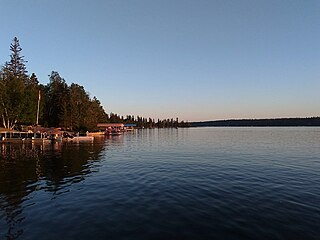
Emma Lake is a recreational lake in the Canadian province of Saskatchewan. It is located near the southern limit of the boreal forest, about 45 kilometres (28 mi) north of Prince Albert. The lake is within the District of Lakeland No. 521 and east of Prince Albert National Park. There are several small communities and recreational opportunities around Emma Lake and much of the northern half is within Great Blue Heron Provincial Park. Access to the lakes is from Highways 953, 952, and 263.

<span class="mw-page-title-main">Waskesiu Lake</span> Lake in Prince Albert National Park, Saskatchewan, Canada

Waskesiu Lake is a lake located roughly in the centre of Prince Albert National Park. The lake's name means red deer or elk in the Cree language. Waskesiu Lake is by far the most developed lake in the park, and features a variety of recreational facilities along all sides of its shoreline, including camping, golfing, boating, and hiking. The resort village of Waskesiu Lake is on its eastern shore. The Prince Albert National Park Nature Centre is located in the village as well as many other amenities such as lodging, police, a gas station, shopping, and restaurants. Access to the lake is from Highways 263 and 264.

<span class="mw-page-title-main">Sturgeon River (Saskatchewan)</span> River in Saskatchewan, Canada

Sturgeon River is a river in the Hudson Bay drainage basin in the central part of the Canadian province of Saskatchewan. It flows from its source in the Waskesiu Hills in Prince Albert National Park to the North Saskatchewan River, just west of the city of Prince Albert.

<span class="mw-page-title-main">Thunder Creek (Saskatchewan)</span> River in Saskatchewan, Canada

Thunder Creek is a river in the Canadian province of Saskatchewan. The watershed of Thunder Creek is within the semi-arid Palliser's Triangle in south-central Saskatchewan. It begins at small, man-made reservoir near Lake Diefenbaker and flows in a south-easterly direction towards the city of Moose Jaw and the Moose Jaw River. The Moose Jaw River is a major tributary of the Qu'Appelle River For most of its course, Thunder Creek follows a valley called the Thunder Creek meltwater channel that was formed over 10,000 years ago near the end of the last ice age.

<span class="mw-page-title-main">Oak Lake (Manitoba)</span> Lake in Manitoba, Canada

Oak Lake is a lake in the south-western part of the Canadian province of Manitoba in a region called Westman. Oak Lake is a kettle lake and is an aquifer supplier for numerous nearby residential areas and farms. The lake is in the RM of Sifton and sits at an elevation of 426 metres above sea level. Provincial Road 254 provides access to the lake.

<span class="mw-page-title-main">Plum Creek (Manitoba)</span> River in Manitoba

Plum Creek is the primary outflow for the Plum Lakes and travels in an easterly direction for about 28 kilometres until it meets up with the Souris River, which is part of the Hudson Bay drainage basin, at the community of Souris in the Canadian province of Manitoba. Plum Lakes and the beginning of Plum Creek are in the Rural Municipality of Sifton and the mouth is in the Municipality of Souris – Glenwood.

Lac des Îles is a lake in Meadow Lake Provincial Park in the Canadian Province of Saskatchewan in the boreal forest ecozone of Canada. The primary inflow is the Cold River and its outflow is the Waterhen River. The lake and associated rivers are part of the Hudson Bay drainage basin as the Waterhen River flows into Beaver River, which meets the Churchill River, a major river that flows into Hudson Bay, at Lac Île-à-la-Crosse.

<span class="mw-page-title-main">Good Spirit Lake</span> Lake in Saskatchewan, Canada

Good Spirit Lake is a lake on the eastern side of the Canadian province of Saskatchewan. It is a shallow lake notable for its naturally sandy beaches, parks, and sand dunes. One of Saskatchewan's six founding provincial parks, Good Spirit Lake Provincial Park, surrounds the western and southern shores of the lake. The lake is in the RM of Good Lake No. 274 and Yorkton, 48 kilometres (30 mi) to the south, is the nearest city. The hamlets of Burgis Beach and Canora Beach–the only two communities on the lake–are located on the eastern shore. The southern shore of the lake is accessed from Highway 229 and the northern shore is accessed from Highway 651. Highway 47 runs north to south west of the lake and Good Spirit Lake Provincial Park.

<span class="mw-page-title-main">Good Spirit Lake Provincial Park</span> Provincial park in Saskatchewan, Canada

Good Spirit Lake Provincial Park is a provincial park on the eastern side of the Canadian province of Saskatchewan. Founded in 1931, the park surrounds the western and southern shores of Good Spirit Lake and is one of Saskatchewan's six founding provincial parks. The park is in the RM of Good Lake No. 274, about 48 kilometres (30 mi) north of the city of Yorkton. Highway 47 runs along the western boundary and Highway 229 provides access to the park's amenities.

<span class="mw-page-title-main">Crescent Creek (Saskatchewan)</span> River in Saskatchewan, Canada

Crescent Creek is a river in the south-east region of the Canadian province of Saskatchewan. The river begins in the Beaver Hills and flows in an easterly direction into Crescent Lake. Crescent Creek is a tributary of Yorkton Creek, which flows north into the Whitesand River–a tributary of the Assiniboine River.

<span class="mw-page-title-main">Cowan River</span> River in Saskatchewan, Canada

Cowan River is a river in the west-central part of the Canadian province of Saskatchewan in the boreal forest ecozone of Canada. The river begins at Cowan Lake Dam near the northern end of Cowan Lake and flows north-west through muskeg and forest to meet Beaver River. Beaver River then flows into Lac Île-à-la-Crosse and the Churchill River. The entirety of Cowen River is within the Northern Saskatchewan Administration District and while there are no communities along its course, the towns of Big River and Spiritwood are in its watershed.

Great Blue Heron Provincial Park is a recreational park in the central region of the Canadian province of Saskatchewan in the boreal forest ecozone of Canada. It is adjacent to the eastern boundary of Prince Albert National Park, about 50 kilometres (31 mi) north of the city of Prince Albert. The provincial park was established in 2013 from two pre-existing provincial recreation sites – Emma Lake and Anglin Lake Recreation Sites – and the addition of a large tract of Crown land.

Anglin Lake is a reservoir in the boreal forest ecozone in the Canadian province of Saskatchewan. It is east of the Prince Albert National Park in the central part of the province in the District of Lakeland No. 521. Access to the lake is from Highway 953 and it is about 70 kilometres (43 mi) north of the city of Prince Albert. The only community on the lake is Anglin Lake.

<span class="mw-page-title-main">Spruce River (Saskatchewan)</span> River in Saskatchewan, Canada

Spruce River, also called Little Red River, is a river in the north-central region of the Canadian province of Saskatchewan. It begins in the Waskesiu Hills in Prince Albert National Park and flows generally in a southward direction through boreal forests, glacier-carved hills and valleys, muskeg, and prairie en route to the North Saskatchewan River at the east end of the city of Prince Albert.

Makwa Lake, which is Cree for Loon Lake, is a lake in the west-central region of the Canadian province of Saskatchewan in the transition zone between parkland and boreal forest. The Battle of Loon Lake, which was last battle of the North-West Rebellion, happened at Steele Narrows, a strait at the entrance to Sanderson Bay on Makwa Lake. The site is now part of Steele Narrows Provincial Park.

Jumbo Lake is a lake in the Canadian province of Saskatchewan in the transition zone between parkland and boreal forest. It is also known as Big Jumbo Lake to differentiate it from adjoining Little Jumbo Lake. Big and Little Jumbo Lakes make up the heart of Makwa Lake Provincial Park and are part of several inter-connected lakes that include Makwa Lake and Upper Makwa Lake. The southern half of the lake is within Makwa Lake Provincial Park and the northern half is within Makwa Lake 129B Indian reserve. Access to both lakes is from Highway 699.

Cypress Lake is an interbasin transfer reservoir in the Canadian province of Saskatchewan on the southern slopes of the Cypress Hills in the Rural Municipality of Reno No. 51. The reservoir was created by the damming of the east and west sides of a much smaller Cypress Lake in the late 1930s. There is a provincial recreation site on the southern shore and a wildlife refuge on Heglund Island in the lake. Access to the lake is from Township Road 60 off of Highway 21.

Fife Lake is a fresh water prairie lake in the Canadian province of Saskatchewan. It is in the south-central part of the province at the eastern end of the Wood Mountain Hills. The entire lake and its shoreline is designated an Important Bird Area (IBA) of Canada to protect the nationally endangered piping plover. While there are no communities along the lake's shore, there is a park and campground at the southern end. Nearby communities include Fife Lake, Rockglen, and Lisieux. Access is from Highway 18.

Eyehill Creek is a river in the Canadian provinces of Alberta and Saskatchewan. The river begins at Sounding Lake in Alberta and flows east and north into Manitou Lake in Saskatchewan. Eyehill Creek is the primary inflow for Manitou Lake, which has no outflow. The Manitou Lake watershed is a large endorheic basin between the Battle River watershed to the north and the South Saskatchewan River watershed to the south.

Bradwell Reservoir is a man-made reservoir in the Canadian province of Saskatchewan in the Rural Municipality of Blucher No. 343. The reservoir was built as part of the South Saskatchewan River Project. That project involved the damming of the South Saskatchewan River with the Gardiner and Qu'Appelle River Dams creating Lake Diefenbaker. From Lake Diefenbaker, a series of aqueducts were built allowing for irrigation and the creation of several reservoirs, including Bradwell Reservoir. The reservoir is owned and operated by the Saskatchewan Water Security Agency. Bradwell Reservoir supplies water to the Nutrien Allan Potash Mine near Allan.

References

  1. "Christopher Lake". Canadian Geographical Names Database. Government of Canada. Retrieved 29 August 2022.
  2. "District of Lakeland". Lakeland 521. Retrieved 29 August 2022.
  3. "Christopher Lake". Geoview.info. Geoview. Retrieved 29 August 2022.
  4. "Christopher Lake Fishing Map". GPS Nautical Charts. Bist LLC. Retrieved 29 August 2022.
  5. "Christopher Creek". Canadian Geographical Names Database. Government of Canada. Retrieved 29 August 2022.
  6. "Water Conveyance & Flood Controls". Water Security Agency. Water Security Agency. Retrieved 29 August 2022.
  7. "Christopher Creek, Saskatchewan Map". Geodata.us. Geodata.us. Retrieved 29 August 2022.
  8. "Management of Spruce River Diversion Project Anglin / Emma / Christopher Lakes" (PDF). Lakeland 521. Saskatchewan Watershed Authority. Retrieved 29 August 2022.
  9. "Slottens Bay". Geoview. Geoview. Retrieved 29 August 2022.
  10. "Kinasai Lutheran Bible Camp". Kinasao. Kinasao Lutheran Bible Camp. Retrieved 29 August 2022.
  11. "Quest at Christopher Lake". Questnet. Quest at Christopher Lake. Retrieved 29 August 2022.
  12. "About Camp Kedash". Camp Kedash. Camp Kedash. Retrieved 29 August 2022.
  13. "Camp Christopher". Camp Christopher. Camp Christopher. Retrieved 29 August 2022.
  14. "Christopher Lake Nature Area Trails". Tourism Saskatchewan. Government of Saskatchewan. Retrieved 29 August 2022.
  15. "Christopher Lake". Fishbrain. Fishbrain. Retrieved 29 August 2022.