Wakaw Lake is a lake in the RM of Hoodoo No. 401 in the central part of the Canadian province of Saskatchewan. It is about 102 kilometres (63 mi) north-east of Saskatoon and 73 kilometres (45 mi) south of Prince Albert. It takes its name from a Cree word meaning "crooked", referring to the curved shape of the lake. The lake is known in Cree as ᐚᑳᐤ ᓵᑲᐦᐃᑲᐣ wâkâw sâkahikan. Wakaw Lake is the source of the Carrot River, which is a 300-kilometre (190 mi) long river that parallels the South Saskatchewan and Saskatchewan Rivers before meeting the Saskatchewan River at The Pas, Manitoba.

Jan Lake is a community on the south-eastern shore of Jan Lake on Doupe Bay in the north-eastern part of the Canadian province of Saskatchewan. The community has a Canadian Coast Guard wharf, provincial and private campgrounds, pubs, as well as many tourist lodges, which focus on fishing, camping, and private cabins. Access is from Highway 135 and Jan Lake Airport, which is located along Highway 135, near the intersection with Highway 106.

Peter Pond Lake is a glacial lake in the north-western part of the Canadian province of Saskatchewan. It is located in the boreal orest and Canadian Shield within the Churchill River drainage basin.

Amisk Lake is a lake in the east-central part of the Canadian province of Saskatchewan, about 22 kilometres (14 mi) south-west of Flin Flon, Manitoba. 'Amisk' means beaver in Cree. Saskatchewan Highway 167 provides road access. Denare Beach, the largest settlement, is located at the north-east corner of the lake.

Tobin Lake is a reservoir along the course of the Saskatchewan River in the Canadian province of Saskatchewan. Tobin Lake was formed by the building of the E.B. Campbell Dam on the Saskatchewan River in 1963. Tobin Lake is named for William Thorburn, who was a fur trader on the Saskatchewan River. He had built a trading post on the Saskatchewan River where it is met by the Petaigan River. The rapids near the post became known as the "Thornburn Rapids". The name was later shortened to "Tobin Rapids".

The Whitesand River is a tributary of the Assiniboine River and finds its headwaters at Whitesand Lake near Invermay in east-central Saskatchewan. Its mouth can be found at its confluence with the Assiniboine River near Kamsack.
Hanson Lake is a lake in the east-central part of the Canadian province of Saskatchewan in the boreal forest ecozone of Canada. The lake is irregularly shaped with many bays, islands, and channels as it was formed by glaciers during the last ice age. It is fed by multiple rivers and creeks from surrounding hills, smaller lakes, and muskeg. Hanson Lake's outflow is through a short river at the eastern end of the lake as it flows into the Sturgeon-Weir River, a tributary of the Saskatchewan River.
Parr Hill Lake, is a lake in the east-central part of the Canadian province of Saskatchewan in the boreal forest ecozone of Canada. It is part of the Swan River drainage basin and is situated in the Porcupine Hills and Saskatchewan's Porcupine Provincial Forest. A block of Porcupine Hills Provincial Park is on the north-eastern shore of the lake. The lake and park are accessed from Highway 982, which is also known as Little Swan Road.
Isbister Lake is a lake in the Canadian province of Saskatchewan. It is located in the east-central part of the province along the course of Midnight Creek in the Porcupine Hills and Porcupine Provincial Forest. The lake is in the Woody River Block of Porcupine Hills Provincial Park. Highway 980 provides access to the southern shore of the lake and its amenities. Isbister Lake is situated in boreal forest surrounded by hills, other small lakes, and muskeg.
Steepbank Lake is a lake in Clarence-Steepbank Lakes Provincial Park in the Canadian province of Saskatchewan. The lake is in a glacier-carved valley in the Boreal forest ecozone of Canada and is part of the Bow River chain of lakes near the headwaters of the Bow River, which is a tributary of Lac la Ronge in the Churchill River watershed.
Great Blue Heron Provincial Park is a recreational park in the central region of the Canadian province of Saskatchewan in the boreal forest ecozone of Canada. It is adjacent to the eastern boundary of Prince Albert National Park, about 50 kilometres (31 mi) north of the city of Prince Albert. The provincial park was established in 2013 from two pre-existing provincial recreation sites – Emma Lake and Anglin Lake Recreation Sites – and the addition of a large tract of Crown land.
Elaine Lake is a lake in the Canadian province of Saskatchewan. It is located north of Prince Albert National Park in the Thunder Hills of the Northern Saskatchewan Administration District.
Beatty Lake is a lake in the Canadian province of Saskatchewan. The lake is set in rolling hills of Jack pine forest and muskeg in Saskatchewan's Northern Administration District. The lake is adjacent to Beaver River near where Beatty Creek flows into Beaver River. Access is from the Hanson Lake Road.
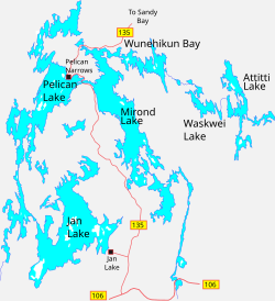
Pelican Lake is a lake in the Northern Administration District of the Canadian Province of Saskatchewan. The lake is situated in Canada's boreal forest. While there are several lakes and small rivers that flow into Pelican Lake, there are two main inflows. At the lake's southern end, a channel flows in from the west from Deschambault Lake. North-east of that, another channel flows in from the east from Jan Lake. Its outflow is through Opawikusehikan Narrows, near Pelican Narrows, into Mirond Lake. Pelican lake is in the Sturgeon-Weir River drainage basin. The Sturgeon-Weir River is a tributary of the Saskatchewan River.
Big Sandy Lake is a lake in the Canadian province of Saskatchewan. The lake is north-east of Narrow Hills Provincial Park at the eastern base of the Cub Hills in the Northern Administration District. It is situated in the Mid-Boreal Uplands Ecoregion in a boreal forest of pine, birch, aspen, and spruce.
Chitek Lake is lake in the Canadian province of Saskatchewan. It is in the Mid-boreal Upland ecozone in the west-central part of Saskatchewan. Most of the lake is the RM of Big River No. 555 and only the very southernmost point is in the RM of Spiritwood No. 496. Along the lake's shores, there's the Chitek Lake Indian reserve, a community, a provincial recreation area, resorts, and outfitters. The outflow is the Chitek River, which flows out from the northern end of the lake. Access is from Highway 24.
Davin Lake is a glacial lake in the boreal forest of the Canadian province of Saskatchewan. On the eastern shore of the lake—at Currie Bay—is a provincial campground and Davin Lake Lodge. The lodge is an outfitters and has cabin and boat rentals. Access to the lake and its amenities is from Highway 905 and Davin Lake Airport. There are no communities on the lake's shore.
Codette Lake, which was named after Métis fur trader Baptiste Codette, is a reservoir in the Canadian province of Saskatchewan. The lake was created in 1986 with the construction of the Francois-Finlay Dam across the Saskatchewan River about 5 kilometres (3.1 mi) upstream from the town of Nipawin. The dam is the site of the Nipawin Hydroelectric Station. Downsteam from Codette Lake is Tobin Lake, which is another man-made lake along the course of the Saskatchewan River that was created in 1963 with the construction of the E.B. Campbell Dam.
Lady Lake is a lake in the Canadian Province of Saskatchewan. It is a natural, spring-fed lake in the Rural Municipality of Preeceville No. 334. The lake is south of the Porcupine Hills and Porcupine Provincial Forest in the Boreal Transition ecozone. Along the lake's western shore is the Lady Lake section of Sturgis & District — Lady Lake Regional Park. To the east of the lake is the Lilian River and the community of Lady Lake. The closest town is Preeceville, which is about 11 kilometres (6.8 mi) by road to the south. Access to the lake and its amenities is from Highway 9.
Granite Lake is a lake in the Canadian province of Saskatchewan. It is situated in the boreal forest in the Churchill River Upland ecozone of Canada. Granite Lake is along the course of the Wildnest River, which drains the much larger Wildnest Lake west into the Sturgeon-Weir River. The Sturgeon-Weir River is a tributary of the Saskatchewan River.