
The South Saskatchewan River is a major river in the Canadian provinces of Alberta and Saskatchewan. The river begins at the confluence of the Bow and Oldman Rivers in southern Alberta and ends at the Saskatchewan River Forks in central Saskatchewan. The Saskatchewan River Forks is the confluence of the South and North Saskatchewan Rivers and is the beginning of the Saskatchewan River.

Poplar River is a tributary of the Missouri River, approximately 167 miles (269 km) long in Saskatchewan in Canada and Montana in the United States. The river is composed of three main forks – West, Middle, and East Poplar Rivers – that have their source in the Wood Mountain Hills of the Missouri Coteau. Along the river's Middle Fork in Saskatchewan, there is a coal-fired power station. There are also dams built along the river's forks.
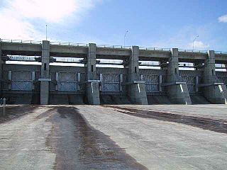
The Gardiner Dam on the South Saskatchewan River in Saskatchewan is the third largest embankment dam in Canada and one of the largest embankment dams in the world. Construction on Gardiner Dam and the smaller Qu'Appelle River Dam was started in 1959 and completed in 1967, creating Lake Diefenbaker upstream and diverting a considerable portion of the South Saskatchewan's flow into the Qu'Appelle River. The dam rises 64 metres (209 feet) in height, is almost 5 km (3.1 mi) long and has a width of 1.5 km (0.93 mi) at its base with a volume of 65,000,000 cubic meters. The dam is owned and operated by the Saskatchewan Water Security Agency.

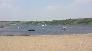
Lake Diefenbaker is a reservoir and bifurcation lake in southern part of the Canadian province of Saskatchewan. It was formed by the construction of Gardiner Dam and the Qu'Appelle River Dam across the South Saskatchewan and Qu'Appelle Rivers respectively. Construction began in 1959 and the lake was filled in 1967. The lake is 225 kilometres (140 mi) long with approximately 800 kilometres (500 mi) of shoreline. It has a maximum depth of 66 metres (217 ft), while the water levels regularly fluctuate 3–9 metres (9–27 feet) each year. The flow of the two rivers is now regulated with a considerable portion of the South Saskatchewan diverted into the Qu'Appelle. Prior to the dams' construction, high water levels in the South Saskatchewan would frequently cause dangerous ice conditions downstream in Saskatoon while the Qu'Appelle would frequently dry up in the summer months.

The Grant Devine Dam, formerly Alameda Dam, is an embankment dam located in the Canadian province of Saskatchewan near Alameda and Oxbow. It was constructed in 1994 to control flows on Moose Mountain Creek and Souris River. It provides flood protection and irrigation for this area of Saskatchewan, along with protection for Minot, North Dakota. The Grant Devine Reservoir provides opportunities for recreational use such as boating and fishing. At the full supply level of 562 metres (1,844 ft), the reservoir holds 105,000,000 m3 (3.7×10⁹ cu ft) of water. The project is owned and operated by the Saskatchewan Water Security Agency (formerly Saskatchewan Watershed Authority).

Blackstrap Lake is a man-made reservoir in central Saskatchewan, Canada, south of Saskatoon in the Rural Municipality of Dundurn No. 314. The lake was created as a reservoir in 1967, as part of the Saskatoon South East Water Supply System. Blackstrap Lake has an area of 1,200 ha and is generally used to support irrigation, and the industrial and municipal water supply.
Indi Lake is a man-made lake in central Saskatchewan, Canada, south of Saskatoon in the Rural Municipality of Dundurn No. 314. The lake was created for irrigation and recreation in 1967 by a dam located at its south end. The lake is part of a greater irrigation and aqueduct system built in the 1960s in Saskatchewan and was named after Indi, an unincorporated railway point nearby on the Canadian National Railway (CNR).

McDonald Lake, also known as Rafferty Reservoir, is a reservoir in the south-eastern part of the Canadian province of Saskatchewan. It was created when the Rafferty Dam was built on the Souris River in 1994. Before the dam was built that flooded the Souris Valley, McDonald Lake was a small lake and marsh on the valley floor adjacent to the Souris River.
Moosomin Lake, also known as Moosomin Reservoir, is a man-made lake in south-eastern part of the Canadian province of Saskatchewan. Created by the damming of Pipestone Creek in 1954, Moosomin Lake is located about 10 kilometres (6.2 mi) south of the town of Moosomin and is in the Souris River watershed. The reservoir's uses include irrigation, water supply, and recreation. Moosomin Lake Regional Park is on lake's western shore.

Lanigan Creek is a river in the Canadian province of Saskatchewan. It is located in the south central part of the province in a region called the Prairie Pothole Region of North America, which extends throughout three Canadian provinces and five U.S. states. It is also within Palliser's Triangle and the Great Plains ecoregion.
Craven Dam is at the confluence of the Qu'Appelle River and Last Mountain Creek and immediately east of the village of Craven on the Qu'Appelle River at LSD SW 24-20-21 W2. It is in the Canadian province of Saskatchewan in the RM of Longlaketon No. 219. The dam does not create a reservoir as its purpose is to regulate water flow along the Qu'Appelle River. The dam is operated by the Saskatchewan Water Security Agency and can be accessed on the north side by Highway 99.
Theodore Reservoir is a man-made reservoir along the course of the Whitesand River in the Canadian province of Saskatchewan. The lake was formed with the building of Theodore Dam in 1964. The reservoir and dam were named after the nearby community of Theodore. Whitesand River is the primary inflow and outflow for the reservoir. Lawrie Creek, which begins in the Beaver Hills, flows into the lake on the western side near the dam.

Spruce River, also called Little Red River, is a river in the north-central region of the Canadian province of Saskatchewan. It begins in the Waskesiu Hills in Prince Albert National Park and flows generally in a southward direction through boreal forests, glacier-carved hills and valleys, muskeg, and prairie en route to the North Saskatchewan River at the east end of the city of Prince Albert.

Swift Current Creek is a river in the Canadian province of Saskatchewan. In the 1800s, Métis buffalo hunters called it Rivière au Courant. This name was also adopted by the North-West Mounted Police on their March West in 1874. In 1883, the name Swift Current Creek was first published on official maps by the Department of the Interior. The river begins at an elevation of over 1,100 metres (3,600 ft) in the Cypress Hills and flows in a north-easterly direction through valleys and coulees en route to Lake Diefenbaker of the South Saskatchewan River in the semi-arid region known as Palliser's Triangle. Notable communities along the river's course include Swift Current, Waldeck, and South Fork.
Reid Lake, also known as Duncairn Reservoir, is a man-made reservoir in the Canadian Province of Saskatchewan. Reid Lake was formed with the construction of the Duncairn Dam in a glacial meltwater channel along the course of Swift Current Creek in 1942. The reservoir was originally built to supply water for the city of Swift Current, for irrigation projects, and to regulate Swift Current Creek levels downstream. The entire lake is part of the Duncairn Reservoir Migratory Bird Sanctuary.
Bradwell Reservoir is a man-made reservoir in the Canadian province of Saskatchewan in the Rural Municipality of Blucher No. 343. The reservoir was built as part of the South Saskatchewan River Project. That project involved the damming of the South Saskatchewan River with the Gardiner and Qu'Appelle River Dams creating Lake Diefenbaker. From Lake Diefenbaker, a series of aqueducts were built allowing for irrigation and the creation of several reservoirs, including Bradwell Reservoir. The reservoir is owned and operated by the Saskatchewan Water Security Agency. Bradwell Reservoir supplies water to the Nutrien Allan Potash Mine near Allan.

Overflowing River is a river in the Canadian provinces of Manitoba and Saskatchewan. It begins in Saskatchewan at Overflow Lake in the Pasquia Provincial Forest and flows in a generally eastward direction into Manitoba and then Lake Winnipegosis. The river traverses boreal forests and muskeg in the Boreal Plains Ecozone, moving from the Mid-Boreal Upland of the Pasquia Hills east to the Mid-Boreal Lowland.
Broderick Reservoir is a reservoir about 11 kilometres (6.8 mi) south-southeast of Outlook in the Canadian province of Saskatchewan in the Rural Municipality of Rudy No. 284. Broderick Reservoir was built in 1967 as part of South Saskatchewan River Project. That project involved the building of aqueducts and a series of reservoirs to supply water for irrigation, consumption, and industry originating at Gardiner Dam at Lake Diefenbaker. Broderick is the first reservoir in the series. Downstream reservoirs include Brightwater Reservoir, Indi Lake, Blackstrap Lake, Bradwell Reservoir, Zelma Reservoir, and Dellwood Reservoir.
Zelma Reservoir is a reservoir in the Canadian province of Saskatchewan in the Rural Municipality of Morris No. 312. It is about 17 kilometres (11 mi) east-southeast of the town of Colonsay. The reservoir was built in 1967 as part of South Saskatchewan River Project. That project, originating at Gardiner Dam of Lake Diefenbaker, involved the building of aqueducts, canals, and a series of reservoirs to supply water for irrigation, consumption, and industry. Other reservoirs in the system include Broderick Reservoir, Brightwater Reservoir, Indi Lake, Blackstrap Lake, Bradwell Reservoir, and Dellwood Reservoir.
Round Lake is a lake in the Canadian province of Saskatchewan within the Rural Municipality of Kelvington No. 366. The lake is at the western edge of the Porcupine Hills and Porcupine Provincial Forest in the Mid-Boreal Upland ecozone. It is 18 kilometres (11 mi) south of Greenwater Lake Provincial Park and 24 kilometres (15 mi) north-northeast of Kelvington. There are no communities along the lake's shore and access is from a gravel road off Highway 38.

