Highway 922 is a provincial highway in the north-west region of the Canadian province of Saskatchewan. It runs from Highway 55 at Bodmin north to Highway 916. It is about 93 kilometres (58 mi) long.
Deschambault Lake is a freshwater lake in the north-eastern region of the Canadian province of Saskatchewan. The identically-named community of Deschambault Lake resides on its shore. There are also four Indian reserves on the lake — Kimosom Pwatinahk 203, Mistik Reserve, Pisiwiminiwatim 207, and Muskwaminiwatim 225 — and a provincial recreation site.

Waskesiu Lake is a lake located roughly in the centre of Prince Albert National Park. The lake's name means red deer or elk in the Cree language. Waskesiu Lake is by far the most developed lake in the park, and features a variety of recreational facilities along all sides of its shoreline, including camping, golfing, boating, and hiking. The resort village of Waskesiu Lake is on its eastern shore. The Prince Albert National Park Nature Centre is located in the village as well as many other amenities such as lodging, police, a gas station, shopping, and restaurants. Access to the lake is from Highways 263 and 264.

Doré Lake is a lake in the Canadian province of Saskatchewan in the basin of the Beaver River. Doré is the French Canadian term for 'walleye'. The lake is north-west of Smoothstone Lake and the Waskesiu Upland in the Mid-Boreal Upland ecozone of Canada and is surrounded by boreal forests. Saskatoon, Saskatchewan's largest city, is about 328 kilometres (204 mi) to the south. The northern village of Dore Lake is located on South Bay and is accessed from Highway 924 and Dore Lake Airport.

Montreal River is a river in the Canadian province of Saskatchewan. It flows 100 kilometres (62 mi) from Montreal Lake to Lac la Ronge and is part of the Churchill River and Hudson Bay drainage basins. Along its course, Montreal River runs through boreal forests, muskeg, and glacier formed valleys. Within its watershed are the Waskesiu Uplands, much of Prince Albert National Park, and several notable lakes, such as Waskesiu, Kingsmere, Crean, Weyakwin, and Bittern.

The Rural Municipality of Big River No. 555 is a rural municipality (RM) in the Canadian province of Saskatchewan within Census Division No. 16 and SARM Division No. 5.

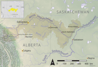
Sturgeon River is a river in the Hudson Bay drainage basin in the central part of the Canadian province of Saskatchewan. It flows from its source in the Waskesiu Hills in Prince Albert National Park to the North Saskatchewan River, just west of the city of Prince Albert.
The Cub Hills are a hilly plateau located south-east of the geographical centre of the Canadian province of Saskatchewan. The hills are in the boreal forest ecozone of Canada and the landforms of the hills were shaped more than 10,000 years ago during last ice age. Throughout the Cub Hills, there are dozens of lakes and rivers and several parks. The Cubs Hills are 150 km (93 mi) north-east of Prince Albert and are in the Northern Saskatchewan Administration District and Census Division #18. Several highways criss-cross the plateau to provide access to the various parks and other amenities.
Saginas Lake, is a lake in the east-central part of the Canadian province of Saskatchewan in the boreal forest ecozone of Canada. It is located along the course of the Pepaw River and is situated in the Porcupine Hills. It is within Saskatchewan's Porcupine Provincial Forest and a portion of Porcupine Hills Provincial Park is on the eastern shore of the lake. Upstream along the Pepaw River is Pepaw and McBride Lakes—both of which lakes also have recreation sites that are part of Porcupine Hills Provincial Park. The lake and park are accessed from Highway 982, also known as Little Swan Road.

Cowan River is a river in the west-central part of the Canadian province of Saskatchewan in the boreal forest ecozone of Canada. The river begins at Cowan Lake Dam near the northern end of Cowan Lake and flows north-west through muskeg and forest to meet Beaver River. Beaver River then flows into Lac Île-à-la-Crosse and the Churchill River. The entirety of Cowen River is within the Northern Saskatchewan Administration District and while there are no communities along its course, the towns of Big River and Spiritwood are in its watershed.
Great Blue Heron Provincial Park is a recreational park in the central region of the Canadian province of Saskatchewan in the boreal forest ecozone of Canada. It is adjacent to the eastern boundary of Prince Albert National Park, about 50 kilometres (31 mi) north of the city of Prince Albert. The provincial park was established in 2013 from two pre-existing provincial recreation sites – Emma Lake and Anglin Lake Recreation Sites – and the addition of a large tract of Crown land.

Spruce River, also called Little Red River, is a river in the north-central region of the Canadian province of Saskatchewan. It begins in the Waskesiu Hills in Prince Albert National Park and flows generally in a southward direction through boreal forests, glacier-carved hills and valleys, muskeg, and prairie en route to the North Saskatchewan River at the east end of the city of Prince Albert.

Waskesiu River is a river that runs through boreal forest in the north-central region of the Canadian province of Saskatchewan. It begins at Waskesiu Lake in Prince Albert National Park and flows north-east to Montreal Lake.
Waskesiu Upland is a hilly plateau in the central region of the Canadian province of Saskatchewan. Waskesiu means red deer or elk in the Cree language. The plateau is just south-west of the geographical centre of the province and consists of two main ranges — the Waskesiu Hills to the south and the Thunder Hills to the north. The Thunder Hills cover an area of about 225,000 acres. Several notable rivers begin from the upland with ones headed south flowing into the North Saskatchewan River and ones headed north flowing into the Churchill River. Much of the plateau is carpeted in boreal forests and most of the Waskesiu Hills range is within Prince Albert National Park. Besides the national park, there are several provincial recreation sites in and around the upland. The northern part of the upland is part of the Northern Saskatchewan Administration District and is sparsely populated.
Elaine Lake is a lake in the Canadian province of Saskatchewan. It is located north of Prince Albert National Park in the Thunder Hills of the Northern Saskatchewan Administration District.
Davin Lake is a glacial lake in the boreal forest of the Canadian province of Saskatchewan. On the eastern shore of the lake — at Currie Bay — is a provincial campground and Davin Lake Lodge. The lodge is an outfitters and has cabin and boat rentals. Access to the lake and its amenities is from Highway 905 and Davin Lake Airport. There are no communities on the lake's shore.
Granite Lake is a lake in the Canadian province of Saskatchewan. It is situated in the boreal forest in the Churchill River Upland ecozone of Canada. Granite Lake is along the course of the Wildnest River, which drains the much larger Wildnest Lake west into the Sturgeon-Weir River. The Sturgeon-Weir River is a tributary of the Saskatchewan River.
Nesslin Lake is a lake in the Canadian province of Saskatchewan. It is situated at the western end of the Waskesiu Upland in the boreal forest ecozone of Canada. Nesslin Lake is within the Churchill River drainage basin of the Hudson Bay.
Ness Lakes are a group of five interconnected lakes — the largest of which is Ness Lake — in the Canadian province of Saskatchewan. They are in the Rural Municipality of Big River No. 555 at the western end of the Waskesiu Hills in the boreal forest ecozone of Canada. The western boundary of Prince Albert National Park is directly to the east and the town of Big River is about 15 kilometres (9.3 mi) to the south-west. Access to the lakes is from Nesslin Lake Road, which branches off of Highway 922.

Smoothstone Lake is a lake in the Canadian province of Saskatchewan along the course of the Smoothstone River. The lake is at the western edge of the Waskesiu Upland in the Mid-Boreal Upland ecozone of Canada and is surrounded by boreal forests. Smoothstone Lake's primary inflow and outflow is the Smoothstone River, which begins in the Waskesiu Upland and ends at Pinehouse Lake of the Churchill River. At the lake's northern end is Selenite Point, Selenite Bay, and the 362.2-hectare (895-acre) Shelter Island. Access to the lake and its amenities is from Highway 917. Highway 929 dead ends near Selenite Bay at the lake's northern end.


