Related Research Articles
Ridgedale is a village in the Canadian province of Saskatchewan within the Rural Municipality of Connaught No. 457 and Census Division No. 14.
Limerick is a village in the Canadian province of Saskatchewan within the Rural Municipality of Stonehenge No. 73 and Census Division No. 3. The village is about 150 km (94 mi) north of the US border near the towns of Lafleche and Gravelbourg. The village is named after the Irish city of Limerick.

Division No. 4 is a census division in Alberta, Canada. It is located in the northeast corner of southern Alberta and its largest urban community is the Town of Hanna. The census division contains all of Alberta's Special Areas as well as the Municipal District of Acadia. Division No. 4 is the smallest census division in Alberta according to population.
Albertville is a village in the Canadian province of Saskatchewan within the Rural Municipality of Garden River No. 490 and is in Census Division No. 15. It is approximately 25 km northeast of the City of Prince Albert.
Chaplin is a village in the Canadian province of Saskatchewan within the Rural Municipality of Chaplin No. 164 and Census Division No. 7. The community is situated on the Trans-Canada Highway approximately 85 km from Moose Jaw and 90 km from Swift Current. The main industries of Chaplin are Saskatchewan Minerals and farming/ranching. Chaplin consists of eight streets, two crescents, and four avenues.
Aylsham is a village in the Canadian province of Saskatchewan within the Rural Municipality of Nipawin No. 487 and Census Division No. 14. The village is approximately 65 km (40 mi) northeast of the city of Melfort.
Holbein is an organized hamlet in Saskatchewan that lies within the Rural Municipality of Shellbrook No. 493.
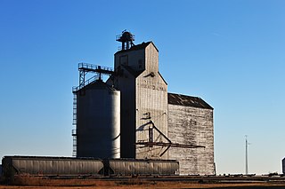
Debden is a village in the Canadian province of Saskatchewan within the Rural Municipality of Canwood No. 494 and Census Division No. 16. The village is located on Highway 55 and is 94 km from the City of Prince Albert and 194 km from the City of Saskatoon. It is also the administrative headquarters of the Big River Cree First Nations band government. The village is at the edge of the Prince Albert National Park and with all the lakes nearby it becomes a popular area in the summer months.
Coderre ) is a village in the Canadian province of Saskatchewan within the Rural Municipality of Rodgers No. 133 and Census Division No. 7. The village is located approximately 85 km southwest of the City of Moose Jaw on Highway 627.
Brownlee is a village in the Canadian province of Saskatchewan within the Rural Municipality of Eyebrow No. 193 and Census Division No. 7. The village is located approximately 58 km northwest of the City of Moose Jaw on Highway 42.

Elbow is a village in the Canadian province of Saskatchewan within the Rural Municipality of Loreburn No. 254 and Census Division No. 11. Elbow was founded in 1909, near what is now Lake Diefenbaker. It is 8 km northwest of Mistusinne, 10 km northwest of Douglas Provincial Park and 16 km southeast of Loreburn. The village got its name from its position on the elbow of the South Saskatchewan River.

Glenside is a village in the Canadian province of Saskatchewan within the Rural Municipality of Rudy No. 284 and Census Division No. 11. The village is located on Highway 219 approximately 10 km east of the Town of Outlook.

Meacham is a village in the Canadian province of Saskatchewan within the Rural Municipality of Colonsay No. 342 and Census Division No. 11. It is located 69 kilometres east of the City of Saskatoon on Highway 2.
Parkside is a village in the Canadian province of Saskatchewan within the Rural Municipality of Leask No. 464 and Census Division No. 16.
Smeaton is a village in the Canadian province of Saskatchewan within the Rural Municipality of Torch River No. 488 and Census Division No. 14. It is at the foot of Hanson Lake Road, which ends at Creighton near Flin Flon, Manitoba). Narrow Hills Provincial Park is 70 km north.
Crutwell is an organized hamlet in the Canadian province of Saskatchewan.
Nesslin Lake is a hamlet in the Canadian province of Saskatchewan. It is the Rural Municipality of Big River No. 555.
Shamrock is a village in the Canadian province of Saskatchewan within the Rural Municipality of Shamrock No. 134 and Census Division No. 7.
Tugaske is a village in the Canadian province of Saskatchewan within the Rural Municipality of Huron No. 223 and Census Division No. 7. It is nicknamed Gateway to Lake Diefenbaker. It is near Eyebrow Lake, a prairie lake in the Qu'Appelle Valley. It was named after an eyebrow-shaped hill also in the Qu'Appelle Valley above Eyebrow Lake. The lake, which is 9 km long and 1 km wide, is a bird sanctuary and is near Highway 627.
Codette is a village in the Canadian province of Saskatchewan within the Rural Municipality of Nipawin No. 487 and Census Division No. 14. The village is located 10 km south of Nipawin at the junction of Highway 35 and Highway 789.
References
- ↑ "Population and dwelling counts: Canada and designated places". Statistics Canada. 9 February 2022. Retrieved 31 August 2022.
53°52′17″N106°55′59″W / 53.87139°N 106.93306°W
| | This article about a location in the Census Division No. 16 of Saskatchewan is a stub. You can help Wikipedia by expanding it. |