Shellmouth Reservoir

Last updated

Lake of the Prairies
Shellmouth Reservoir
LakeofthePrairies1.JPG
Lake of the Prairies from the Shellmouth Dam
Canada Manitoba relief location map.jpg
Red pog.svg
Lake of the Prairies
Location in Manitoba
Canada relief map 2.svg
Red pog.svg
Lake of the Prairies
Lake of the Prairies (Canada)
Location R.M. of Shellmouth-Boulton / R.M. of Shell River, Manitoba and Cote No. 271, Saskatchewan
Coordinates 51°08′40″N101°30′19″W / 51.14444°N 101.50528°W / 51.14444; -101.50528
Type reservoir
Primary inflows Shell River
Primary outflows Assiniboine River
Basin  countries Canada
Max. length56 km (35 mi)
Surface area61.5 km2 (23.7 sq mi)
Water volume480×10^6 m3 (390,000 acre⋅ft)
Surface elevation425 m (1,394 ft)
References [1]
Shellmouth Dam
Shellmouth.jpg
An aerial view of Shellmouth Dam and Reservoir
Coordinates 50°57′49″N101°25′07″W / 50.96361°N 101.41861°W / 50.96361; -101.41861
PurposeMulti-purpose
StatusOperational
Construction began1964
Opening date1971
Construction cost$10.8 m CAD
Built by Prairie Farm Rehabilitation Administration
Owner(s)Government of Manitoba
Dam and spillways
Type of dam Embankment dam
Height (foundation)21.3 m (70 ft)
Width (crest)1,270 m (4,170 ft)
Website
gov.mb.ca/mit/wms/shellmouth/

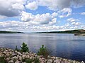
The Shellmouth Reservoir (also known as Lake of the Prairies) is a man-made reservoir on the Assiniboine River in Manitoba and Saskatchewan, Canada. [2]

Contents

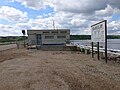
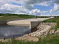
The Shellmouth Dam ( 50°57′49″N101°25′07″W / 50.96361°N 101.41861°W / 50.96361; -101.41861 ) is a multi-purpose embankment dam built by the Prairie Farm Rehabilitation Administration (PFRA). [2]

The dam and reservoir are part of a strategy to reduce the risk of flood damage for Winnipeg and other communities along the Assiniboine River. [2] For example, in the 1997 Red River flood, the inflow to the reservoir peaked at 10,000 cubic feet per second (280 m3/s) while the outflow never exceeded 1,700 cu ft/s (48 m3/s). [3] The reservoir is also used to supplement flows on the Assiniboine when conditions are dry, ensuring water supply for Brandon, Portage la Prairie, irrigators, and some industries. For example in early August, 2021 the flow in Brandon was a little over 9 m3/s while the outflow from Shellmouth was 5.7 m3/s and inflow was less than 0.5 m3/s. Therefore without the dam the flow in the Assiniboine at Brandon would be a bit under 4 m3/s.

Asessippi Provincial Park is established around the southern arm of the lake.

Specifications

The dam is 70 feet (21 m) high and 4,200 feet (1,300 m) long. [2]

The reservoir is 35 miles (56 km) in length and stores 390,000 acre feet (480 million cubic metres) at the spillway crest level of 1,408.5 feet (429.3 m). Outflows are controlled by a gated conduit and a 210-foot (64 m) wide concrete chute spillway. The normal summer level target is between 1,400 feet (430 m) and 1,404 feet (428 m). [2]

Fish species

Fish species include walleye, yellow perch, northern pike, mooneye, burbot, rock bass, brown bullhead, white sucker, shorthead redhorse and common carp. Rock bass are Saskatchewan's only native bass.

See also

Related Research Articles

<span class="mw-page-title-main">Lake Manitoba</span> Lake in Manitoba, Canada

Lake Manitoba is the 14th largest lake in Canada and the 33rd largest lake in the world with a total area of 4,624 km2 (1,785 sq mi). It is located within the Canadian province of Manitoba about 75 km (47 mi) northwest of the province's capital, Winnipeg, at 50°59′N98°48′W.

<span class="mw-page-title-main">Red River Floodway</span> Artificial flood control channel in Manitoba, Canada

The Red River Floodway is an artificial flood control waterway in Western Canada. It is a 47 km (29 mi) long channel which, during flood periods, takes part of the Red River's flow around the city of Winnipeg, Manitoba to the east and discharges it back into the Red River below the dam at Lockport. It can carry floodwater at a rate of up to 140,000 cubic feet per second (4,000 m3/s), expanded in the 2000s from its original channel capacity of 90,000 cubic feet per second (2,500 m3/s).

<span class="mw-page-title-main">Assiniboine River</span> River in Western Canada

The Assiniboine River is a 1,070-kilometre (660 mi) river that runs through the prairies of Western Canada in Saskatchewan and Manitoba. It is a tributary of the Red River. The Assiniboine is a typical meandering river with a single main channel embanked within a flat, shallow valley in some places and a steep valley in others. Its main tributaries are the Qu'Appelle, Souris, and Whitesand Rivers. For early history and exploration see Assiniboine River fur trade.

<span class="mw-page-title-main">Souris River</span> River in Canada and the United States

The Souris River or Mouse River is a river in central North America. Approximately 435 miles (700 km) in length, it drains about 23,600 square miles (61,100 km2) in Canada and the United States.

<span class="mw-page-title-main">Oroville Dam</span> Dam in California

Oroville Dam is an earthfill embankment dam on the Feather River east of the city of Oroville, California, in the Sierra Nevada foothills east of the Sacramento Valley. At 770 feet (235 m) high, it is the tallest dam in the U.S. and serves mainly for water supply, hydroelectricity generation, and flood control. The dam impounds Lake Oroville, the second-largest reservoir in California, capable of storing more than 3.5 million acre-feet (1.1×10^12 US gal; 4.3×10⁹ m3).

<span class="mw-page-title-main">Asessippi Provincial Park</span> Provincial park in Manitoba, Canada

Asessippi Provincial Park is a provincial park in the Rural Municipality of Riding Mountain West, Manitoba, Canada.

<span class="mw-page-title-main">Portage Diversion</span> Spillway in Manitoba, Canada

The Portage Diversion is a water control structure on the Assiniboine River near Portage la Prairie, Manitoba, Canada. The project was made as part of a larger attempt to prevent flooding in the Red River Valley. The Portage Diversion consists of two separate gates which divert some of the flow of water in the Assiniboine River to a 29 km long diversion channel that empties into Lake Manitoba near Delta Beach. This helps prevent flooding on the Assiniboine down river from the diversion, including in Winnipeg, where the Assiniboine River meets the Red River.

<span class="mw-page-title-main">Wilson Lake (Kansas)</span> Reservoir in Russell and Lincoln counties in Kansas

Wilson Lake is a reservoir in the U.S. state of Kansas, on the border of Russell County and Lincoln County. Built and managed by the U.S. Army Corps of Engineers for flood control, it is also used for wildlife management and recreation. Several parks are located along its shoreline, including Wilson State Park.

<span class="mw-page-title-main">Little Saskatchewan River</span> River in Canada

The Little Saskatchewan River is a river in western Manitoba. It originates in Riding Mountain National Park at Lake Audy and flows about 65 miles (105 km) south through the communities of Minnedosa and Rapid City. Its approximate length is 185 km. It joins the Assiniboine River about 6 miles (9.7 km) west of Brandon. The watershed has an area of 1,400 square miles (3,600 km2). The watershed includes numerous lakes and three man made reservoirs (Minnedosa Lake, Rapid City Reservoir and Lake Wahtopanah.

<span class="mw-page-title-main">Lake Wahtopanah</span> Artificial lake in Rural Municipality of Daly / Rural Municipality of Saskatchewan, Manitoba

Lake Wahtopanah, also known as Rivers Reservoir, is a lake on the Little Saskatchewan River near the town of Rivers, Manitoba. Its dam is the Rivers Dam.

<span class="mw-page-title-main">John Redmond Reservoir</span> Reservoir in Coffey County, Kansas

John Redmond Reservoir is a reservoir on the Neosho River in eastern Kansas. Built and managed by the U.S. Army Corps of Engineers, it is used for flood control, recreation, water supply, and wildlife management. It borders the Flint Hills National Wildlife Refuge to the northwest.

<span class="mw-page-title-main">Risks to the Glen Canyon Dam</span> Aspect of dam construction

Glen Canyon Dam, a concrete arch dam on the Colorado River in the American state of Arizona, is viewed as carrying a large amount of risk, most notably due to siltation. The Colorado and San Juan rivers deposit large volumes of silt into Lake Powell, slowly decreasing its capacity. The sediment will eventually build up against the dam and could affect its safe operation and lead to its failure.

<span class="mw-page-title-main">Keith Sebelius Lake</span> Reservoir in Norton County, Kansas

Keith Sebelius Lake, formerly known as Norton Reservoir, is a man-made reservoir on Prairie Dog Creek in northwest Kansas. Built and managed by the U.S. Bureau of Reclamation, it is used for flood control, irrigation, recreation, and local water supply. Prairie Dog State Park is located on its shore.

<span class="mw-page-title-main">Amistad Dam</span> Dam in Texas / Acuña Municipality, Coahuila

Amistad Dam is a major embankment dam across the Rio Grande between Texas, United States, and Coahuila, Mexico. Built to provide irrigation water storage, flood control, and hydropower generation, it is the largest dam along the international boundary reach of the Rio Grande. The dam is over 6 miles (9.7 km) long, lies mostly on the Mexican side of the border, and forms Amistad Reservoir. It supplies water for irrigation in the Rio Grande Valley, 574 miles (924 km) upstream of the Rio Grande's mouth on the Gulf of Mexico at Brownsville, Texas/Matamoros, Tamaulipas.

The 2011 Assiniboine River flood was caused by above average precipitation in Western Manitoba and Saskatchewan. This was a 1 in 300 year flood that affected much of Western Manitoba. The flooding in Manitoba was expected to mostly involve the 2011 Red River Flood but instead the more severe flooding was found on the Assiniboine in the west.

<span class="mw-page-title-main">Council Grove Lake</span> Reservoir in Morris County, Kansas

Council Grove Lake is a reservoir on the Neosho River in east-central Kansas. Built and managed by the U.S. Army Corps of Engineers, it is used for flood control, recreation, and water supply.

<span class="mw-page-title-main">Morena Dam</span> Dam in San Diego County, California

Morena Dam is a rockfill dam across Cottonwood Creek, a tributary of the Tijuana River, in southern San Diego County, California in the United States. Originally completed in 1912 and raised several times afterward, the dam is one of the oldest components of the city of San Diego's municipal water system, providing between 1,600 to 15,000 acre-feet of water per year. It is one of the few facilities in the San Diego water supply system that relies entirely on local runoff.

<span class="mw-page-title-main">2014 Assiniboine River flood</span> Disaster in Manitoba and Saskatchewan, Canada

The 2014 Assiniboine River flood was caused by above average precipitation in western Manitoba and Saskatchewan. Unlike most prior floods, this flood was not due to spring runoff, but rather significant rainfall. Flooding and high water involved both the main stem of the Assiniboine River and many of its tributaries including the Qu'Appelle River and the Souris River. The flood came just 3 years after the 2011 Assiniboine River Flood which was considered a 1 in 300 year event. Peak flows along the river for the first crest were generally slightly less than in 2011. However, the second peak on the river has exceeded 2011 levels starting near St. Lazare, Manitoba up to Brandon, Manitoba so far.

<span class="mw-page-title-main">Lake St. Martin</span> Lake in Manitoba, Canada

Lake St. Martin is a lake in the Interlake region of Manitoba, Canada on Treaty 2 Land. The Lake is situated between Lake Manitoba and Lake Winnipeg. Lake St. Martin is downstream from the Fairford River with its Fairford River Control Structure. The Fairford River is the only outlet for Lake Manitoba. With the artificially increased flow and limited outflow, Lake St. Martin was turned into a reservoir. The outflow for Lake St. Martin exits through Dauphin River and into Lake Winnipeg, at a lower rate than the water comes in.

<span class="mw-page-title-main">Oroville Dam crisis</span> Potential failure during 2017 rainstorm

In February 2017, heavy rainfall damaged Oroville Dam's main and emergency spillways, prompting the evacuation of more than 180,000 people living downstream along the Feather River and the relocation of a fish hatchery.

References

  1. "Manitoba Infrastructure: Shellmouth Dam and Reservoir". Government of Manitoba. Retrieved 22 November 2021.
  2. 1 2 3 4 5 "Water Management and Structures | Infrastructure | Province of Manitoba". www.gov.mb.ca. Retrieved 7 August 2021.
  3. "Flood Control Works". Prairiewaternews.ca. Archived from the original on 15 January 2013.