
The Red River, also called the Red River of the North to differentiate it from the Red River in the south of the continent, is a river in the north-central United States and central Canada. Originating at the confluence of the Bois de Sioux and Otter Tail rivers between the U.S. states of Minnesota and North Dakota, it flows northward through the Red River Valley, forming most of the border of Minnesota and North Dakota and continuing into Manitoba. It empties into Lake Winnipeg, whose waters join the Nelson River and ultimately flow into Hudson Bay.

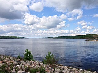
Lake Manitoba is the 14th largest lake in Canada and the 33rd largest lake in the world with a total area of 4,624 square kilometres (1,785 sq mi). It is located within the Canadian province of Manitoba about 75 kilometres (47 mi) northwest of the province's capital, Winnipeg, at 50°59′N98°48′W.

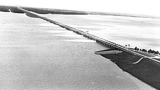
The Red River Floodway is an artificial flood control waterway in Western Canada. It is a 47 km (29 mi) long channel which, during flood periods, takes part of the Red River's flow around the city of Winnipeg, Manitoba to the east and discharges it back into the Red River below the dam at Lockport. It can carry floodwater at a rate of up to 140,000 cubic feet per second (4,000 m3/s), expanded in the 2000s from its original channel capacity of 90,000 cubic feet per second (2,500 m3/s).

The Assiniboine River is a 1,070-kilometre (660 mi) river that runs through the prairies of Western Canada in Saskatchewan and Manitoba. It is a tributary of the Red River. The Assiniboine is a typical meandering river with a single main channel embanked within a flat, shallow valley in some places and a steep valley in others. Its main tributaries are the Qu'Appelle, Souris, and Whitesand Rivers. For early history and exploration see Assiniboine River fur trade.

The Red River flood of 1997 was a major flood that occurred in April and May 1997 along the Red River of the North in Minnesota, North Dakota, and southern Manitoba. It was the most severe flood of the river since 1826. The flood reached throughout the Red River Valley, affecting the cities of Fargo and Winnipeg, but none so greatly as Grand Forks and East Grand Forks, where floodwaters reached more than 3 miles (4.8 km) inland. They inundated virtually everything in the twin communities. Total damages for the Red River region were US$3.5 billion. The flood was the result of abundant snowfall and extreme temperatures.

The Souris River or Mouse River is a river in central North America. Approximately 435 miles (700 km) in length, it drains about 23,600 square miles (61,100 km2) in Canada and the United States.
The Shellmouth Reservoir is a man-made reservoir on the Assiniboine River in Manitoba and Saskatchewan, Canada.

Winnipeg lies at the bottom of the Red River Valley, a low-lying flood plain with an extremely flat topography. This valley was formed by the ancient glacial Lake Agassiz which has rich deposits of black soil. Winnipeg is on the eastern edge of the Canadian Prairies in Western Canada; it is known as the 'Gateway to the West'. It is relatively close to many large Canadian Shield lakes and parks, as well as Lake Winnipeg. Winnipeg is bordered by tallgrass prairie to the west and south and the aspen parkland to the northeast.
Delta Marsh consists of an extensive open marsh located near the south shore of Lake Manitoba, approximately 24 km north of the town of Portage la Prairie, Manitoba. The marsh extends for nearly 30 km along the shore of the lake, and has a breadth of up to 4 km. The marsh consists of a network of interconnected shallow bays separated from Lake Manitoba by a wooded barrier dune ridge of 300m to 600m width.
The Morganza Spillway or Morganza Control Structure is a flood-control structure in the U.S. state of Louisiana. It is located along the western bank of the Lower Mississippi River at river mile 280, near Morganza in Pointe Coupee Parish. The spillway stands between the Mississippi and the Morganza Floodway, which leads to the Atchafalaya Basin and the Atchafalaya River in south-central Louisiana. Its purpose is to divert water from the Mississippi River during major flood events by flooding the Atchafalaya Basin, including the Atchafalaya River and the Atchafalaya Swamp. The spillway and adjacent levees also help prevent the Mississippi from changing its present course through the major port cities of Baton Rouge and New Orleans to a new course down the Atchafalaya River to the Gulf of Mexico. The Morganza Spillway, operated by the U.S. Army Corps of Engineers, was opened during the 1973 and 2011 Mississippi River floods.
The history of flooding in Canada includes floods caused by snowmelt runoff or freshet flooding, storm-rainfall and "flash flooding", ice jams during ice formation and spring break-up, natural dams, coastal flooding on ocean or lake coasts from storm surges, hurricanes and tsunamis. Urban flooding can be caused by stormwater runoff, riverine flooding and structural failure when engineered flood management structures, including dams and levees, prove inadequate to manage the quantities and force of flood waters. Floods can also occur when groundwater levels rise entering buildings cracks in foundation, floors and basements. Flooding is part of the natural environmental process. Flooding along large river systems is more frequent in spring where peak flows are often governed by runoff volume due to rainfall and snowmelt, but can take place in summer with flash floods in urban systems that respond to short-duration, heavy rainfall. Flooding due to hurricanes, or downgraded severe storms, is a concern from August to October when tropical storms can affect Eastern North America. Flood events have had a significant effect on various regions of the country. Flooding is the costliest natural disaster for Canadians. Most home insurance claims in Canada deal with water damage due to sewer back-up, not fire.

The 2009 Red River flood along the Red River of the North in North Dakota and Minnesota in the United States and Manitoba in Canada brought record flood levels to the Fargo-Moorhead area. The flood was a result of saturated and frozen ground, spring snowmelt exacerbated by additional rain and snow storms, and virtually flat terrain. Communities along the Red River prepared for more than a week as the U.S. National Weather Service continuously updated the predictions for the city of Fargo, North Dakota, with an increasingly higher projected river crest. Originally predicted to reach a level of near 43 feet (13 m) at Fargo by March 29, the river in fact crested at 40.84 feet (12.45 m) at 12:15 a.m. March 28, and started a slow decline. The river continued to rise to the north as the crest moved downstream.
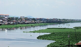
The Manggahan Floodway is an artificially constructed waterway in Metro Manila, Philippines. The floodway was built in 1986, with the cost of 1.1 billion pesos, in order to reduce flooding along the Pasig River during the rainy season, by diverting the peak water flows of the Marikina River to Laguna de Bay, which serves as a temporary reservoir. In case the water level on the lake is higher than the Marikina River, the floodway can also reverse the flow.

Twin Lakes Beach, also known locally by many as simply Twin Beaches, is a beach and community in the Canadian province of Manitoba. On Lake Manitoba, it is about 100 kilometres (62 mi) north-west of the provincial capital, Winnipeg. Twin Lakes Beach is in both the Rural Municipality of St. Laurent and the Rural Municipality of Woodlands, and it is in the town of St. Laurent.
Major floods along the Mississippi River in April and May 2011 were among the largest and most damaging recorded along the U.S. waterway in the past century, comparable in extent to the Great Mississippi Flood of 1927 and Great Flood of 1993. In April 2011, two large storm systems deposited record levels of rainfall on the Mississippi River drainage basin. When that additional water combined with the springtime snowmelt, the river and many of its tributaries began to swell to record levels by the beginning of May. Flooding occurred in Illinois, Missouri, Kentucky, Tennessee, Arkansas, Mississippi, and Louisiana.
The 2011 Assiniboine River flood was caused by above average precipitation in Western Manitoba and Saskatchewan. This was a 1 in 300 year flood that affected much of Western Manitoba. The flooding in Manitoba was expected to mostly involve the 2011 Red River Flood but instead the more severe flooding was found on the Assiniboine in the west.

The Fairford River is a river of Manitoba, Canada. It flows out of the north end of Lake Manitoba into Lake Pineimuta and Lake St. Martin.

The 2014 Assiniboine River flood was caused by above average precipitation in western Manitoba and Saskatchewan. Unlike most prior floods, this flood was not due to spring runoff, but rather significant rainfall. Flooding and high water involved both the main stem of the Assiniboine River and many of its tributaries including the Qu'Appelle River and the Souris River. The flood came just 3 years after the 2011 Assiniboine River Flood which was considered a 1 in 300 year event. Peak flows along the river for the first crest were generally slightly less than in 2011. However, the second peak on the river has exceeded 2011 levels starting near St. Lazare, Manitoba up to Brandon, Manitoba so far.

Lake St. Martin is a lake in the Interlake region of Manitoba, Canada. The lake is situated between Lake Manitoba and Lake Winnipeg. Lake St. Martin is downstream from the Fairford River with its Fairford River Control Structure. The Fairford River is the only outlet for Lake Manitoba. With the artificially increased flow and limited outflow, Lake St. Martin was turned into a reservoir. The outflow for Lake St. Martin exits through Dauphin River and into Lake Winnipeg, at a lower rate than the water comes in.

The Fargo-Moorhead (FM) Area Diversion project, officially known as the Fargo-Moorhead Metropolitan Area Diversion Flood Risk Management Project, is a large, regional flood control infrastructure project on the Red River of the North, which forms the border between North Dakota and Minnesota and flows north to Lake Winnipeg in Manitoba, Canada.


