
The South Saskatchewan River is a major river in the Canadian provinces of Alberta and Saskatchewan. The river begins at the confluence of the Bow and Oldman Rivers in southern Alberta and ends at the Saskatchewan River Forks in central Saskatchewan. The Saskatchewan River Forks is the confluence of the South and North Saskatchewan Rivers and is the beginning of the Saskatchewan River.

The Qu'Appelle River is a river in the Canadian provinces of Saskatchewan and Manitoba that flows 430 kilometres (270 mi) east from Lake Diefenbaker in south-western Saskatchewan to join the Assiniboine River in Manitoba, just south of Lake of the Prairies, near the village of St. Lazare. It is in a region called the Prairie Pothole Region of North America, which extends throughout three Canadian provinces and five U.S. states. It is also within Palliser's Triangle and the Great Plains ecoregion.

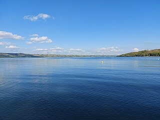
Lake Diefenbaker is a reservoir and bifurcation lake in southern part of the Canadian province of Saskatchewan. It was formed by the construction of Gardiner Dam and the Qu'Appelle River Dam across the South Saskatchewan and Qu'Appelle Rivers respectively. Construction began in 1959 and the lake was filled in 1967. The lake is 225 kilometres (140 mi) long with approximately 800 kilometres (500 mi) of shoreline. It has a maximum depth of 66 metres (217 ft), while the water levels regularly fluctuate 3–9 metres (9–27 feet) each year. The flow of the two rivers is now regulated with a considerable portion of the South Saskatchewan diverted into the Qu'Appelle. Prior to the dams' construction, high water levels in the South Saskatchewan would frequently cause dangerous ice conditions downstream in Saskatoon while the Qu'Appelle would frequently dry up in the summer months.

The Fishing Lakes, also called the Calling Lakes or the Qu'Appelle Lakes, are a chain of four lakes in the Qu'Appelle Valley cottage country about 40 miles (64 km) to the north-east of Regina in the Canadian province of Saskatchewan. The lakes are in a region called the Prairie Pothole Region of North America, which extends throughout three Canadian provinces and five U.S. states. It is also within Palliser's Triangle and the Great Plains ecoregion. The Fishing Lakes all follow the course of the Qu'Appelle River, which flows from the west to the east and is part of the Hudson Bay drainage basin. The lakes sit in the deep-cut Qu'Appelle Valley that was formed about 14,000 years ago during the last ice age. Meltwater from the glaciers carved out the valley and as water levels rose and fell, alluvium was left in the wake. These piles of alluvium are what created the separations between the lakes.

Highway 35 is a paved undivided provincial highway in the Canadian province of Saskatchewan.. It runs from the US Border near Port of Oungre to a dead end near the north shore of Tobin Lake. Saskatchewan Highway 35 (SK Hwy 35) is about 569 kilometres (354 mi) long. The CanAm Highway comprises Saskatchewan Highways 35, SK Hwy 39, SK Hwy 6, SK Hwy 3, SK Hwy 2 and U.S. Route 85. 74.6 kilometres (46.4 mi) of SK Hwy 35 contribute to the CanAm Highway between Port of Oungre on the Canada – United States border and Weyburn. Mudslides, and spring flooding were huge road building and maintenance problems around Nipawin as well as along the southern portion of the route named the Greater Yellow Grass Marsh. Over 20 early dams were built until the problem was addressed with the Rafferty-Alameda Project on the Souris River and the construction of the Qu'Appelle River Dam which have helped to eliminate washed out roads and flooded communities. The highway through the homesteading community followed the Dominion Land Survey on the square until reaching the Saskatchewan River at Nipawin. The completion of the combined railway and traffic bridge over the Saskatchewan River at Nipawin in the late 1920s retired the ferry and basket crossing for traffic north of Nipawin. The E.B. Campbell Dam built in 1963 northeast of Nipawin created Tobin Lake, and Codette Lake was formed with the construction of the Francois-Finlay Hydroelectric dam at Nipawin. The railway/traffic bridge that formed part of Highway 35 was the only crossing utilized at Nipawin until a new traffic bridge was constructed in 1974. The new bridge then became part of the combined Highway 35 and 55 until the highway parts just east of White Fox. Highway 35 then continued north along the west side of Tobin Lake. The railway/traffic bridge continues to be utilized for one lane vehicle traffic controlled by traffic lights, and continues as the "old highway 35" on the west side of the river until it joins with the current Highway 35/55.

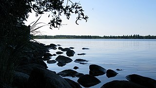
Last Mountain Lake, also known as Long Lake, is a prairie lake formed from glaciation 11,000 years ago. It is located in south central Saskatchewan, Canada, about 40 kilometres (25 mi) north-west of the city of Regina. It flows into the Qu'Appelle River via Last Mountain Creek, which flows past Craven. It is approximately 93 km (58 mi) long, and 3 km (1.9 mi) wide at its widest point. It is the largest naturally occurring body of water in southern Saskatchewan. Only Lake Diefenbaker, which is man-made, is larger. The lake is a popular resort area for residents of south-eastern Saskatchewan.

Duck Mountain Provincial Park is a provincial park, located in the Canadian province of Saskatchewan 14 kilometres (8.7 mi) east of the town of Kamsack and stretches about 12 kilometres (7.5 mi) eastward to the Saskatchewan / Manitoba boundary. The park covers approximately 150 km2 (58 sq mi). Road access to the park is via Highway 57, which connects Saskatchewan Highway 5 to Manitoba Highway 83.
Highway 247 is a provincial highway in the Canadian province of Saskatchewan. Saskatchewan's 200-series highways primarily service its recreational areas. The highway follows the course of the Qu'Appelle River running east from Highway 47 to Highway 9. It is about 50 kilometres (31 mi) long.
Candle Lake is a reservoir in the central part of the Canadian province of Saskatchewan in the boreal forest, approximately 80 kilometres (50 mi) north-east of Prince Albert. A dam completed in 1979 at the southern end of the lake regulates water levels; several small creeks feed into the lake and Torch River flows out of the lake at the dam. Candle Lake Provincial Park surrounds most of the lake and the resort village of Candle Lake is at the southern end.

Tobin Lake is a reservoir along the course of the Saskatchewan River in the Canadian province of Saskatchewan. Tobin Lake was formed by the building of the E.B. Campbell Dam on the Saskatchewan River in 1963. Tobin Lake is named for William Thorburn, who was a fur trader on the Saskatchewan River. He had built a trading post on the Saskatchewan River where it is met by the Petaigan River. The rapids near the post became known as the "Thornburn Rapids". The name was later shortened to "Tobin Rapids".

Buffalo Pound Lake is a eutrophic prairie lake in Saskatchewan, Canada, formed from glaciation about 10,000 years ago, on the Qu'Appelle River approximately 28 kilometres (17 mi) north of Moose Jaw and 11 kilometres (6.8 mi) north-east of Tuxford. The lake gets its name from the method used by First Nations people to capture the bison using the natural topography as corrals or buffalo pounds. Bison, once numbering more than 60 million on the prairies but almost extinct by 1900, were reintroduced into the area in 1972.

Blackstrap Lake is a man-made reservoir in central Saskatchewan, Canada, south of Saskatoon in the Rural Municipality of Dundurn No. 314. The lake was created as a reservoir in 1967, as part of the Saskatoon South East Water Supply System. Blackstrap Lake has an area of 1,200 ha and is generally used to support irrigation, and the industrial and municipal water supply.
Crooked Lake is a recreational lake located in the south-eastern region of the Canadian province of Saskatchewan. It is part of a chain of lakes in the Qu'Appelle Valley and, like many of the other lakes in the valley, there's a dam at the eastern end that controls water levels.

Katepwa Lake is a recreational lake in the Qu’appelle Valley in the Canadian province of Saskatchewan. The lake's name likely originated from the Cree word Kahtapwao, which means "What is calling?" Katepwa Lake is eastern most and farthest downstream of four lakes along the Qu'Appelle River known as the Fishing Lakes. Highway 56 runs along the eastern and southern shore and Highway 619 runs along the south-eastern shore.

Lac la Plonge is a glacial lake in the Canadian province of Saskatchewan in the basin of the Beaver River, near Lac Île-à-la-Crosse. It is located in the boreal forest near the Canadian Shield. On the lake's northern shore, the community of Lac La Plonge, a resort, and campgrounds are accessed via Highway 165.
Last Mountain Creek is a river in south-central Saskatchewan. It is a tributary of the Qu'Appelle River in a region called the Prairie Pothole Region of North America, which extends throughout three Canadian provinces and five U.S. states. It is also within Palliser's Triangle and the Great Plains ecoregion.
Echo Lake is a lake along the course of the Qu'Appelle River in the Canadian province of Saskatchewan. Echo Lake is so named because of the echo heard by the First Nations while paddling on the lake. It is one of four lakes that make up the Fishing Lakes. Pasqua Lake is upstream and Mission Lake is downstream. The lake can be accessed by Highway 56 and Highway 210. In 1942, a 4-metre (13 ft) high dam was built on the Qu'Appelle River at Echo Lake's outflow to control the lake's water levels.
Mission Lake, also known as Lebret Lake, is a lake in the Canadian province of Saskatchewan. It is one of four lakes in the Qu'Appelle Valley known as the Fishing Lakes. Echo Lake is upstream and Katepwa Lake is downstream. The lake was named Mission after the Catholic mission at Lebret. Highways 22 35, and 56 provide access to the lake.
Douglas Provincial Park is a provincial park in the Canadian province of Saskatchewan. Established in 1973, it is named after Tommy Douglas, the seventh premier of Saskatchewan and father of Canada's first single-payer, universal health care programme. The park is located along the Gordon McKenzie Arm of Lake Diefenbaker and at the Qu'Appelle River Dam, which is the source of the Qu'Appelle River. The closest community is Elbow and access to the park is from Highway 19.
Crooked Lake Provincial Park is a recreational provincial park in the south-east region of the Canadian province of Saskatchewan. It is situated along the north-eastern shore of Crooked Lake in the Qu'Appelle Valley in the RM of Grayson No. 184. The community of Sunset Beach is adjacent to the eastern boundary of the park and access is from Highway 247.

